FTO 08-18-2022: Monsoon Rains Continue, But More Breaks In Heavy Rainfall Anticipated

Issue Date: Thursday, August 18th, 2022
Issue Time: 2:55PM MDT
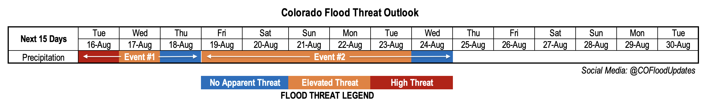
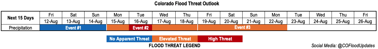
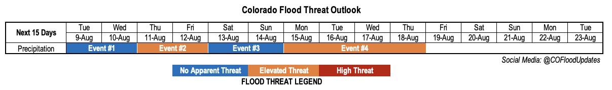
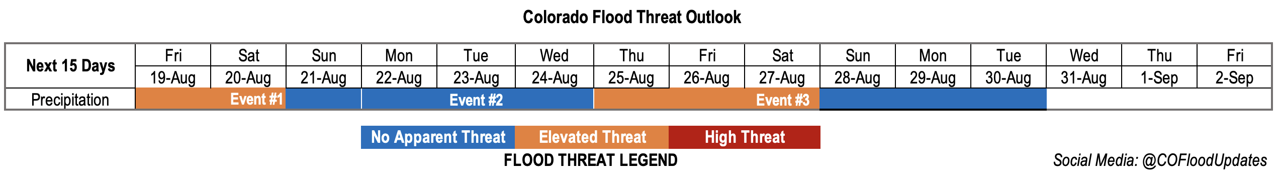
Valid Dates: 8/19 – 9/2

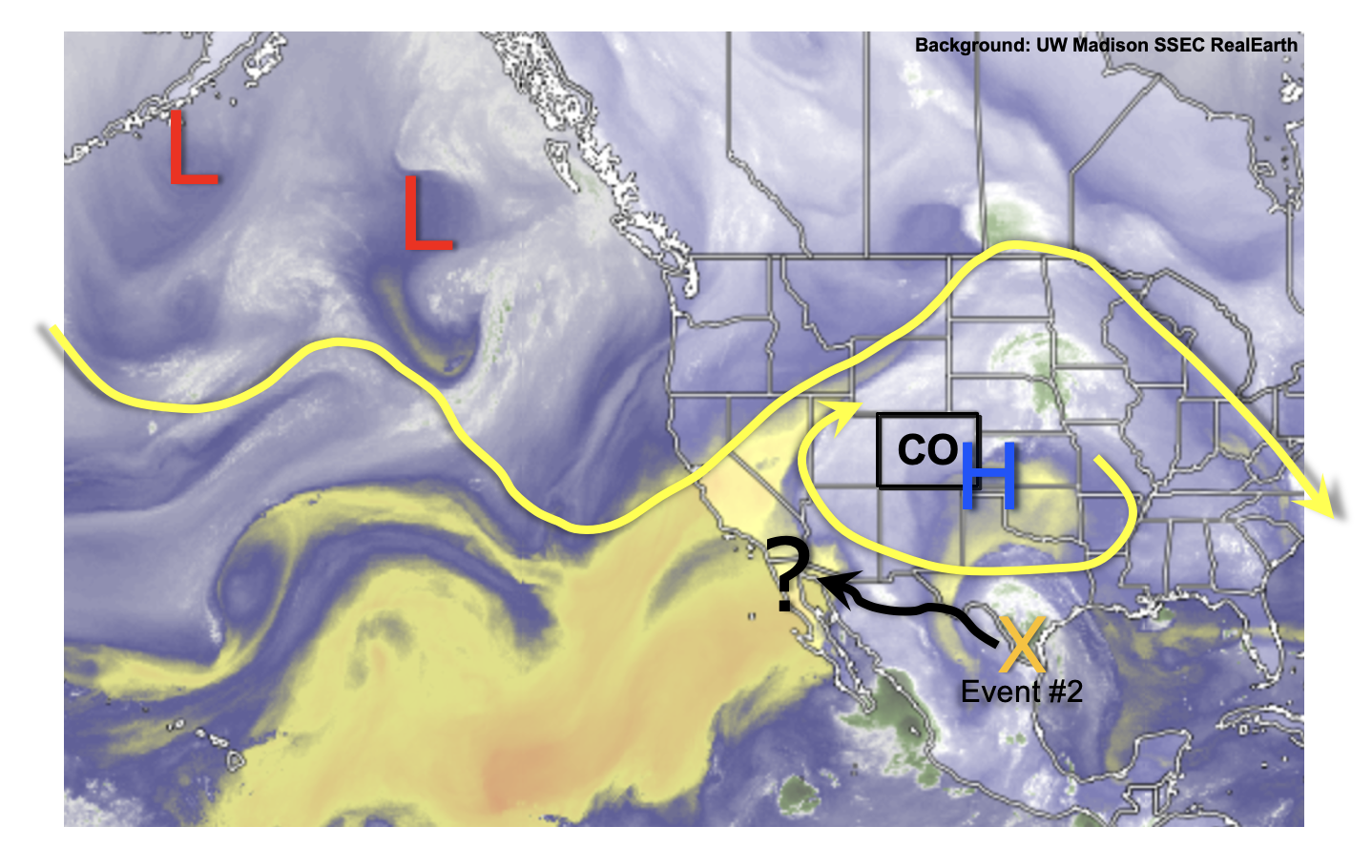
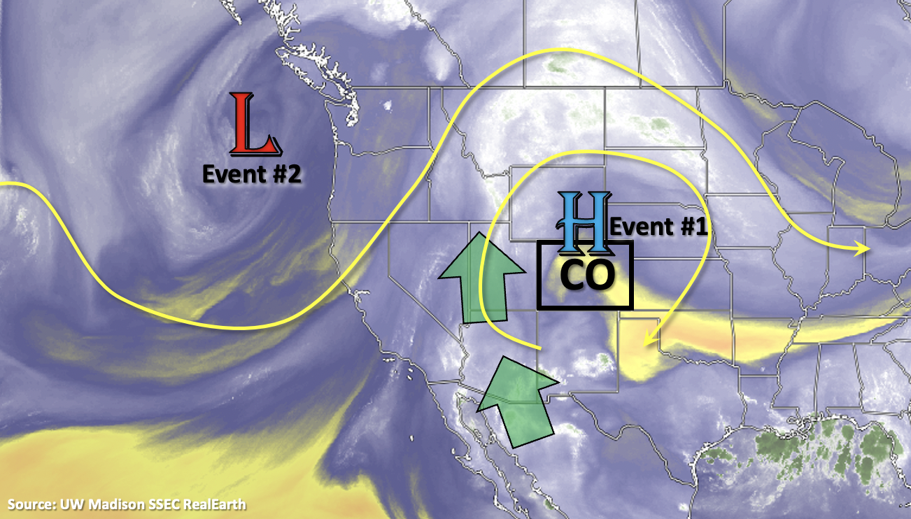
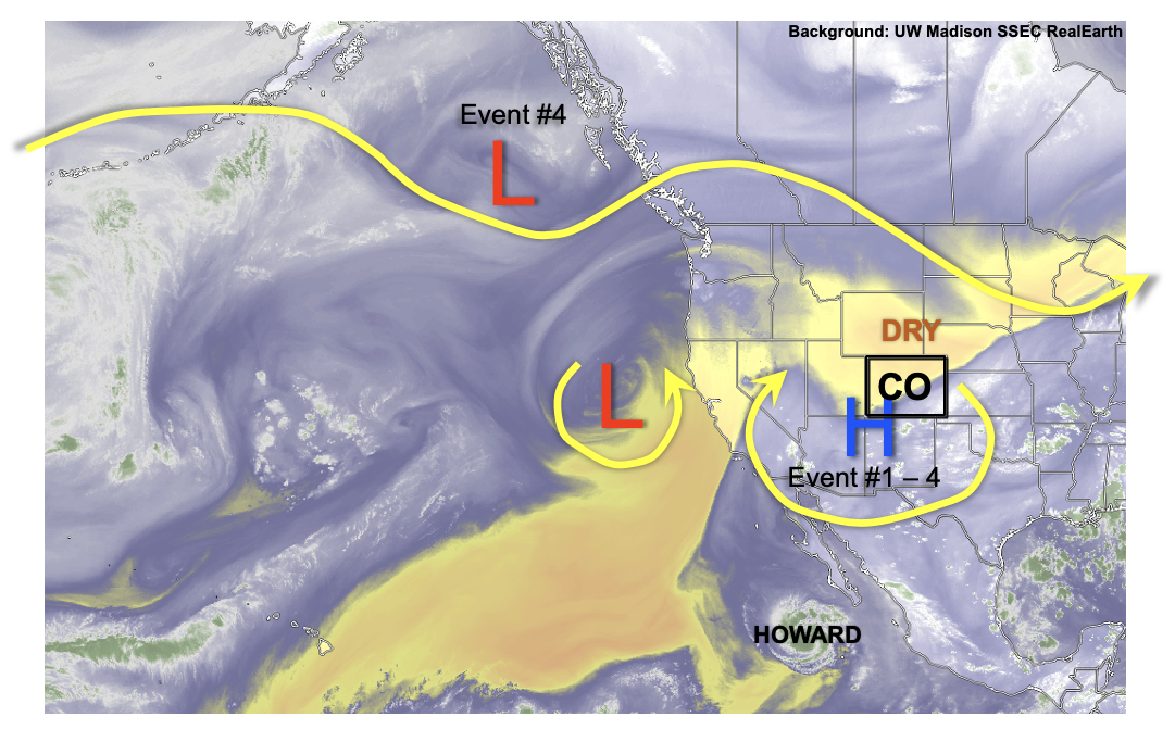
The state should finally start to see some relief from monsoon rainfall next week, but not before a quick and low-end 2-day Elevated flood threat for tomorrow and Saturday. An incoming Low along with some moisture is expected to help to boost mid-level energy and rain rates for Friday and Saturday before a drying trend begins on Sunday. Without any mechanism to mix out residual moisture, afternoon mountain storms are forecast through Wednesday with the weak ridge beginning to rebuild overhead (Event #2). By the end of next week, a shortwave is likely to breakdown the ridge and drop a weak cold front through the state. Unsure about the longevity of the heavy rainfall threat, but post frontal upslope flow will likely Elevate the flood threat for a couple of days during this period (Event #3). Long-term guidance is then starting to show a true drying trend, so Event #3 should be short-lived. With the next shot at a complete dry day sometime during the last week of August, the state should easily reach 75 days of consecutive precipitation.

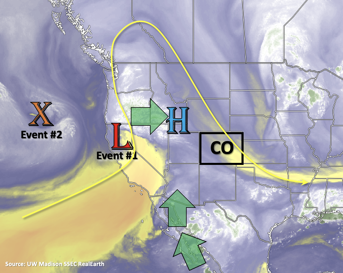
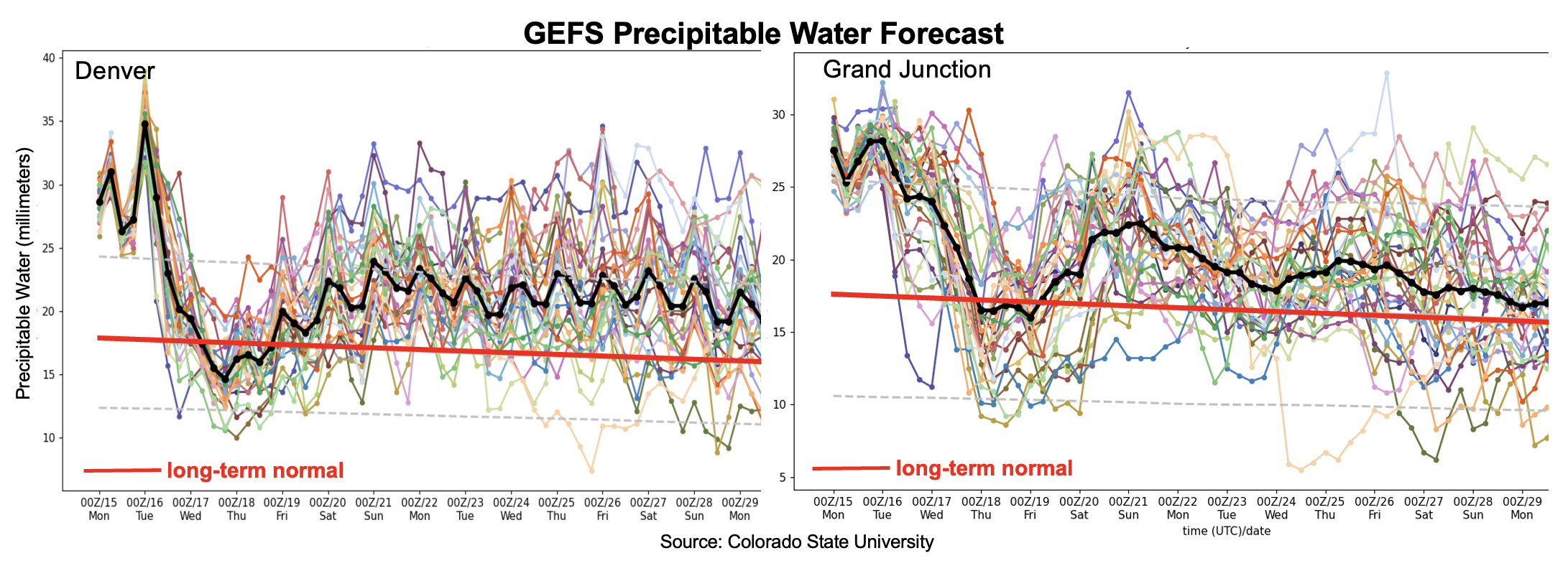
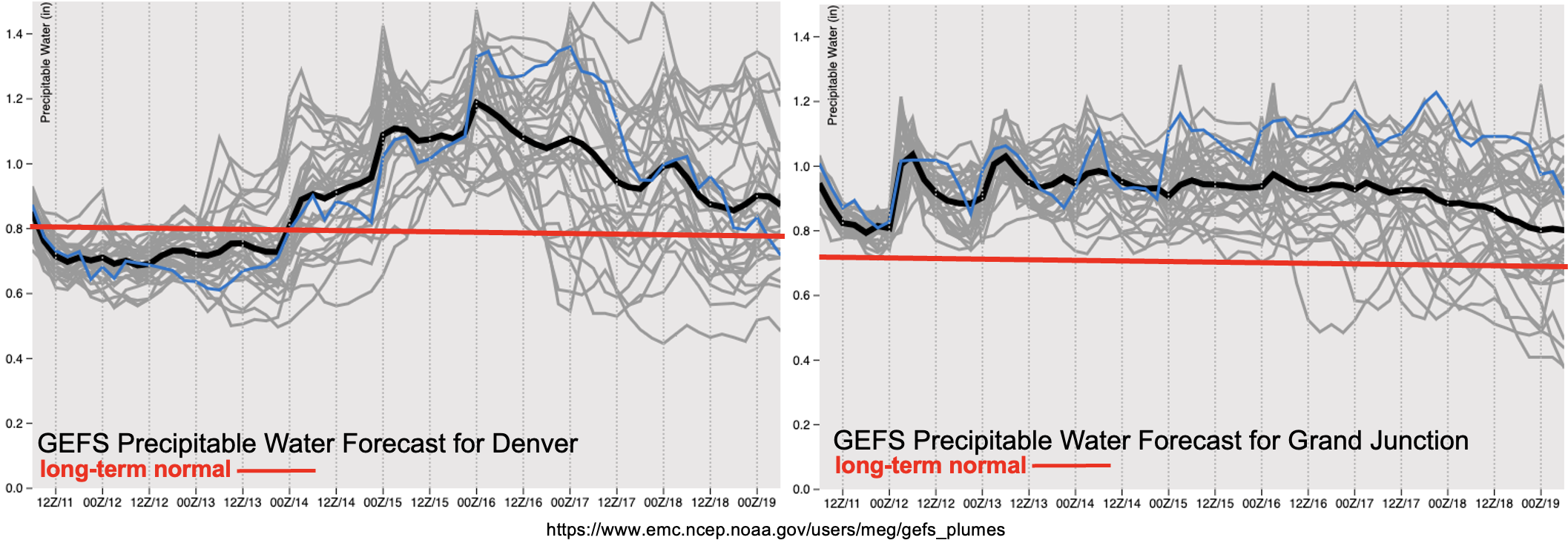
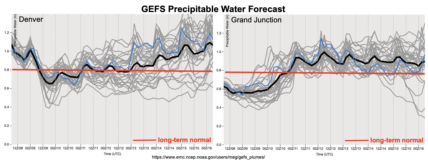
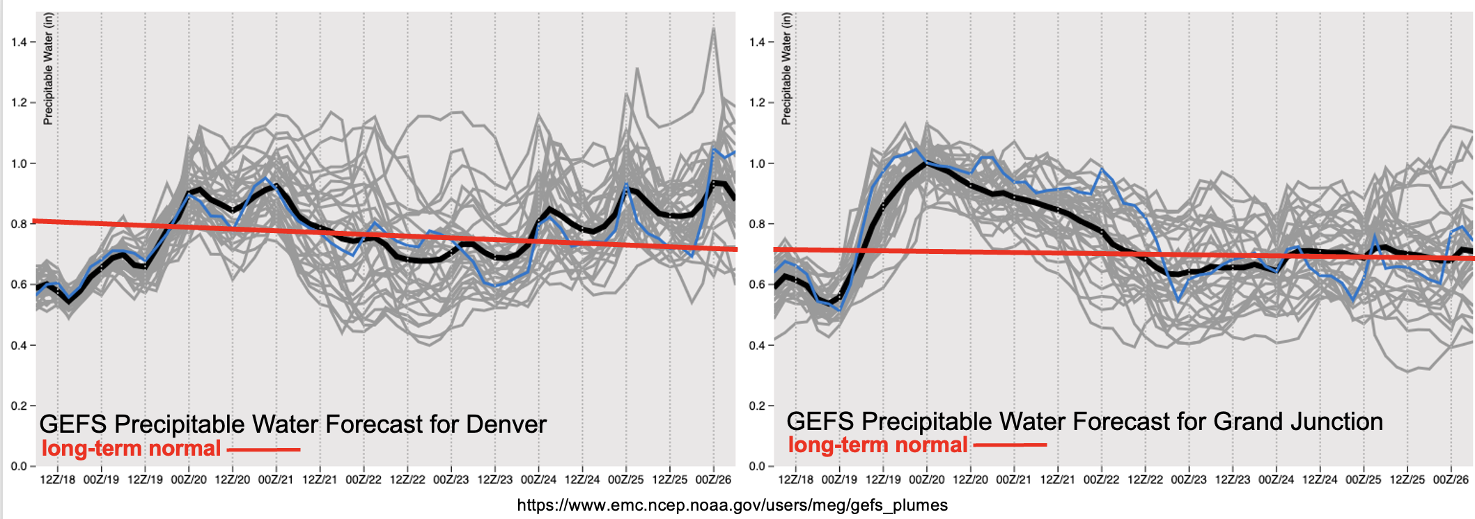
The quick upturn in moisture can be seen both east and west in the PW plumes below. It’s quite the turnaround in moisture return over western Colorado, which will be the focus of the Elevated flood threat tomorrow. PW then begins to drop off to more normal values for late August afternoon Saturday, which means rainfall should stick around in the forecast, but there is No Apparent threat. There is an outside chance for a low-end flood threat during Event #2, but only if a shortwave can move through during peak heating and surface moisture does not mix out. This would be most likely to occur over the central or southern high terrain earlier in the week. There is also increasing confidence that afternoon mountain storms should become more widely scattered by Wednesday with drier air moving overhead. By the end of the week, PW anomalies (not shown) are showing a slight increase to moisture again, but changes to the forecast are anticipated as Event #3 gets closer.

Event #1: Friday – Sunday (8/19 – 8/21)

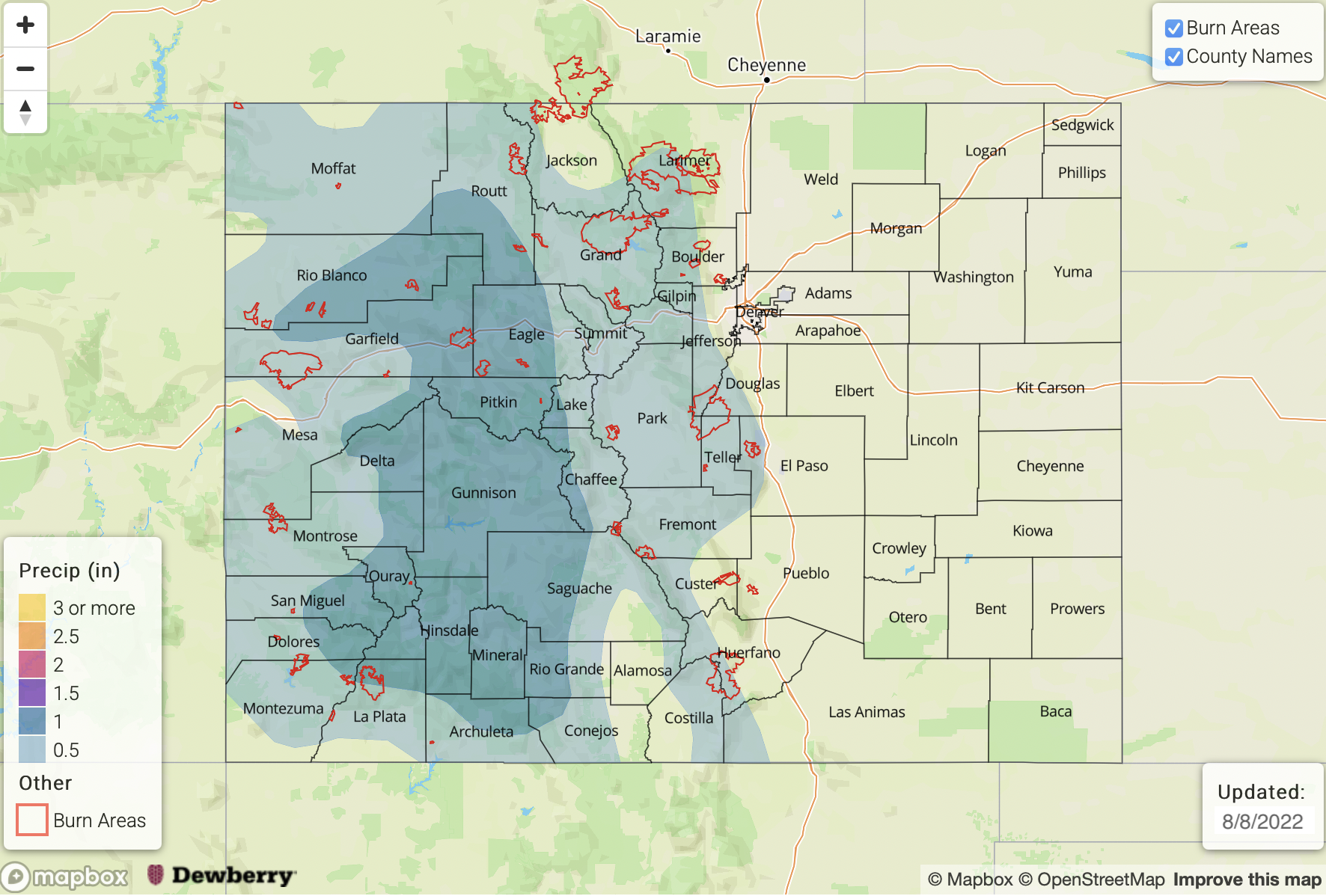
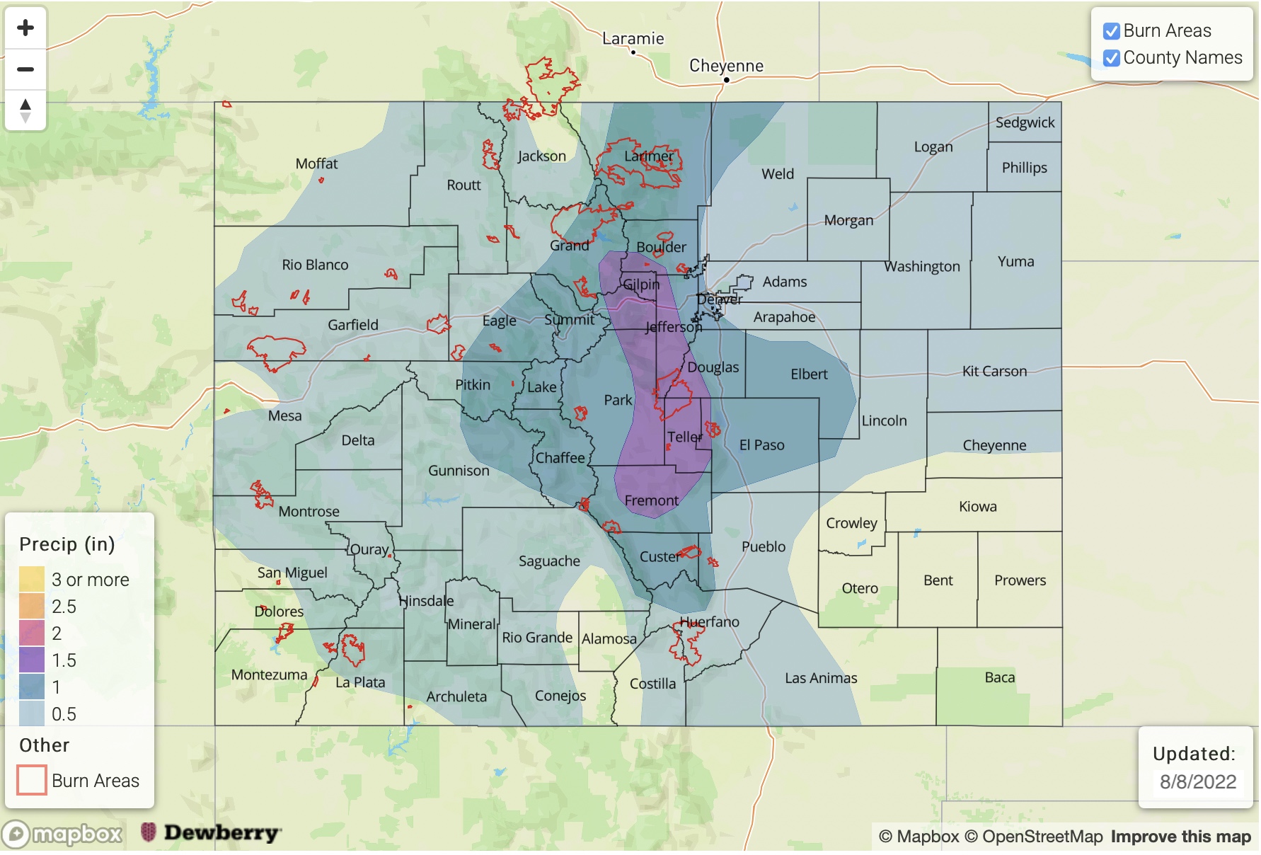
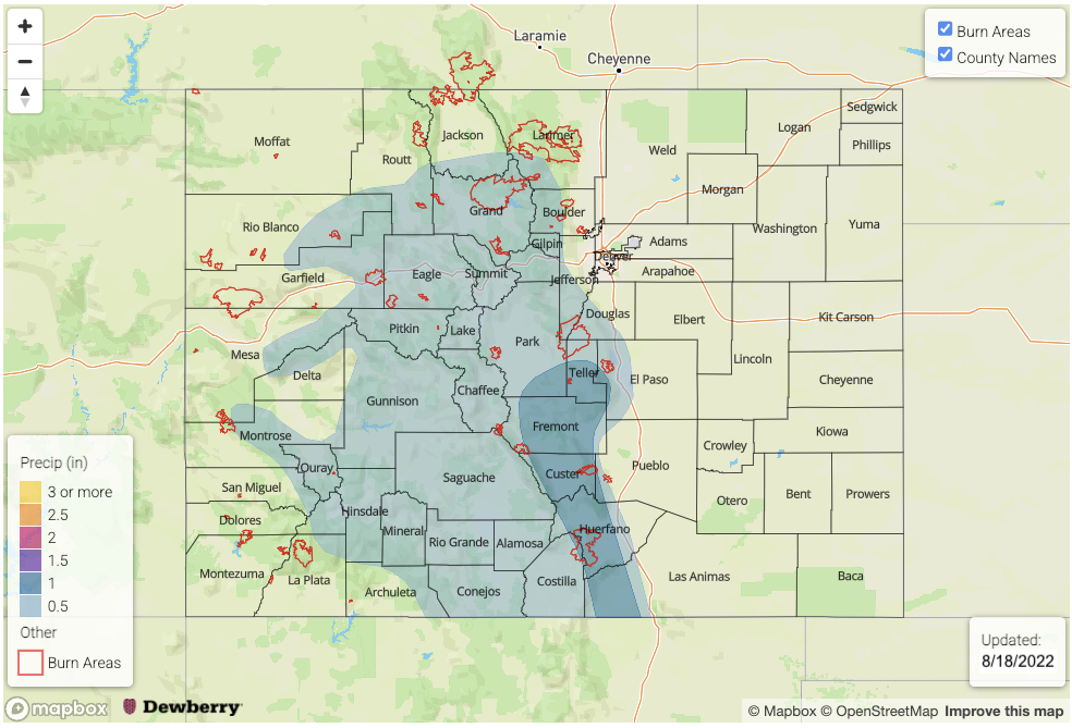
Mid-level lift and an increase in moisture will return the flood threat through Saturday, and an Elevated threat has been issued for high terrain over western, central and southern Colorado.

More widespread rainfall should return to western high terrain and mountains on Friday with some spillover into the Urban Corridor possible with northwest steering flow. Max 1-hour rain rates up to 1.25 inches and 3-hour totals up to 1.75 inches will be possible along with small hail and strong winds from the thunderstorms that develop. Heading into Saturday, the heavy rainfall threat shifts to the southern high terrain, including the Raton Ridge, with steering flows becoming more southerly. Similar 1-hour rain rates are anticipated with some longer duration rainfall helping to increase totals over the southern and central mountains. The Elevated threat for both events are on the low-end, but debris slides, mud flows and road flooding will be possible over steep terrain.

Event #2: Monday – Wednesday (8/22 – 8/24)

Residual moisture and some mid-level lift should keep scattered to widely scattered storms over the mountains in the forecast, but at this time there is No Apparent threat.

Not much to mix out the moisture and mid-level energy trapped under a building ridge, so this will likely lead to mountain showers developing each afternoon. Max 30-minute rain rates up to 0.75 inches will be possible at the beginning of the event but decreasing surface moisture should reduce rain rates by Wednesday. If a well-defined shortwave moves through the flow at peak heating during the first part of the week, there may be a low-end flood threat issued for a particular area. However, the likelihood of this happening is low enough that flooding is not expected at this time. Afternoon high temperatures should also begin their upward trend during this event with 90°Fs returning to the forecast across the lower elevations of the Grand Valley and Northeast Plains by Wednesday.

Event #3: ThursdayTuesday (8/25 – 8/27)

Quick Elevated flood threat issued for the end of the week before a drying trend takes place.

There will likely be a 1- or 2-day Elevated flood threat at the end of the week as a passing trough to the north pushes a cold front through the state. Before that front pushes through, afternoon temperatures should get quite warm with 90°Fs forecast for most of the lower elevations (below 6000ft). Currently, long-term guidance has the front moving through Thursday evening or Friday. Depending on the timing of the frontal passage, some rainfall may be possible over the eastern plains. Post-frontal upslope flow during this active monsoon season will likely keep the flood threat elevated for at least a day. Details with this event are sure to evolve, and due to low confidence in precipitation placement, no map has been drawn. Be sure to tune back into the FTO next Monday and Thursday for the latest.

FTO 08-15-2022: Early High Flood Threat, Then Downtick But Uncertainty Looms Down South

Issue Date: Monday, August 15th, 2022
Issue Time: 9AM MDT
Valid Dates: 8/16 – 8/30

Today will mark the 66th consecutive day of precipitation somewhere across Colorado, with many of those days hosting at least isolated heavy rainfall. While we see some overall drying in the far longer-term (in consistency with climatological peak in moisture levels during early August), plenty of heavy rainfall and flooding concerns are still present in this Outlook, at least over the next 5-7 days.

As seen in the water vapor image, below, the monsoonal upper-level ridge continues to occupy a familiar spot as throughout the summer: just southeast of Colorado. With the clockwise circulation around this ridge, a pulse of monsoonal moisture has managed to essentially rotate all the way around the Four Corners over the past 96 hours. This is a notable feat given that typically, at least some dry air impedes such large-scale movement. But in this situation, there is actually additional moisture being brought in from the north from a couple of frontal-type disturbances arising from the northeast Pacific. Today’s High flood threat (see Bulletin) will carry over into Tuesday as the moisture surge pushes southward (Event #1). Widespread heavy rainfall is anticipated over mainly southern and southeast Colorado, which will keep flash flooding chances especially high over the steeper terrain. By Wednesday, moisture will drop significantly statewide though the far southern and southwest border could still retain enough ingredients for a low-end flood threat. Calmer conditions are expected for Thursday as subsidence and moisture temporarily limit storms to the isolated variety.

Things once again turn more active by Friday (Event #2) as the next pulse of monsoonal moisture takes aim at Colorado. This can be seen in both the Denver and Grand Junction forecast PW plumes, below. At least a low-end Elevated flood threat is anticipated, mainly for the higher terrain though some spillover onto the eastern Plains is possible. By Sunday, things turn quite interesting as the remnants of a moist tropical disturbance could send some significant moisture back into Colorado. There is large uncertainty with this outcome in the guidance, so only a low-end Elevated threat is anticipated at this time mainly along the NM border. However, if some of the newest guidance stays consistent, a higher flood threat could develop over southern Colorado, extending into the Southeast Plains. A widespread, heavy rainfall event could transpire by early next week over the US southern Great Plains, which would be excellent news given the recent dry weather there.

Temperature-wise, seasonably cool weather is thus expected statewide over the next 5-7 days amidst plenty of afternoon cloudiness and persistently cooler mid-level temperatures. Longer-term, the upper-level ridge is expected to eventually move to slightly northwest of Colorado, which would drop moisture a bit and provide seasonably warm and quieter weather. But given how this season has gone thus far, we are not yet ready to buy this solution!

The identified precipitation events are described in more detail below.

Event #1: Tuesday – Thursday (August 16 – August 18)

High Flood Threat Tuesday For Southeast Colorado, Then Downtick Through Thursday

Widespread heavy rainfall is expected for mainly southern and southeast Colorado on Tuesday. Max 1-hr to 3-hr rainfall amounts up to 2.5 inches and 4.0 inches are possible, respectively, with the most vulnerable areas being the Southeast Mountains, Raton Ridge and Southeast Plains. The flood threat will be highest over the steeper terrain though at least isolated flash flooding is likely to occur over the lower elevations of the Southeast Plains. At this time, it does not appear that rainfall duration will be long enough for a major riverine threat but smaller basins could experience some minor flooding.

By Wednesday, the heavy rainfall threat will shift along the New Mexico border with max 1-hour rainfall up to 1.5 inches possible.

Event #2: Friday – Wednesday (August 19 – August 24)

Elevated Flood Threat Friday and Saturday, With Significant Uncertainty From Sunday Onwards

A low-end Elevated flood threat is expected by Friday and Saturday for mainly the southwest, southern and central higher terrain. Max 30-min/60-min rain rates up to 0.9 and 1.4 inches will be possible, which could trigger flash flooding, debris slides and mud flows over steeper terrain. Lower elevation precipitation chance look limited at this time, but this could change.

By Sunday, depending on the aforementioned outcome of the tropical moisture position, a higher flood threat could emerge for southern and southeast Colorado. At this time, the “most likely” outcome is for a low-end Elevated flood threat for 30-60 minute duration heavy rainfall. The next Outlook should provide more detail on this situation, including whether or not a higher threat is warranted.

FTO 08-11-2022: Break In Heavy Rainfall Chances This Weekend With the Flood Threat Likely Returning Next Week

Issue Date: Thursday, August 11th, 2022
Issue Time: 2:45PM MDT
Valid Dates: 8/12 – 8/26

There has been a welcome break in heavy rainfall over the last couple of days, which should continue through early this weekend before more widespread rainfall and the chance for heavy rain returns to the forecast. That also means that the state should continue its rain-day streak through this next FTO period with plenty of afternoon and evening rainfall forecast with the subtropical High migrating across the western US. For Event #1, the center of the High will move slightly west of Colorado before rebuilding back over the Great Basin next week (Event #2). This summer ridge should also help to keep hot temperatures in the forecast until a cold front drops through Colorado early next week and brings some relief from the heat starting on Tuesday. Northwesterly flow aloft is then forecast through the end of next week, which will likely allow for shortwaves to move through the state and help increase the chance for rainfall over the adjacent plains.

While there’s a nice cap and drying over eastern Colorado today, PW values should have a quick upturn behind the passage of the cold front early next week with values returning to much above normal for this time of year. A High flood threat has been issued for Tuesday with an Elevated threat issued Monday and through the end of next week. There is a chance for Wednesday’s threat to be upgraded in Monday’s FTO, but at this time, there is concern that continuous rainfall and cloud cover may inhibit instability to build, and thus limit the flood threat. Over western Colorado, PW values look to remain elevated over the next week keeping rainfall in the forecast each day with the best chance for higher accumulations central/south (right, below). Daily surface moisture and small disturbances will need to be tracked in the FTB with on and off flood low-end flood threats likely to be issued for the area. Overall, this long monsoon season looks to stay active with a peak in the flood threat anticipated early to mid-next week.

Event #1: Friday – Sunday (8/12 – 8/14)

No Apparent flood threat for scattered high terrain storms due to lack of surface moisture.

Although there is a slight increase in storm coverage anticipated over the mountains and western high terrains this weekend, storm cores should be relatively small and lack rainfall rate intensities to cause a flood response. Max 30-min/1-hour rain rates up 0.7/0.9 inches will be possible along with strong outflow winds and dangerous lightning under the more intense storms that develop. Best chance for a minor flood threat day would be on Sunday due to an increase of mid-level lift and moisture moving in from the west. This would most likely occur over the northern and central mountain areas.

Event #2: Monday – Thursday (8/15 – 8/18)

Longer duration precipitation along a front and post-frontal moisture will cause a High/Elevated flood threat to be issued next week.

The calm weather won’t last long as the High finally breaks down and allows a cold front to push through the state early next week. There is an increased likelihood that PW values will return to well above average, especially east, and some heavier rainfall may fall over the adjacent plains in a 3 to 6 hour period. The forecast becomes more complicated on Wednesday in a post-frontal upslope flow regime with ongoing convection and cloud cover potentially limiting instability, and thus the flood threat. Still, with PW well above average, some longer duration rainfall may be able to exceed the 1.75 inch/3-hour flood threat threshold. The Elevated flood threat issued on Wednesday and Thursday is for the southern mountains.

Event #3: Friday – Monday (8/19 – 8/22)

Another monsoon surge looks likely over the weekend, causing an Elevated flood threat to be issued.

It is still a bit far out for many details about this third event, but long-term guidance hints at some mid-level energy and favorable monsoon moisture returning the state for next weekend. If the northwest flow sets up overhead as anticipated, it is likely that a couple weak disturbances could move through the flow and help expand precipitation into the eastern plains. More updated and accurate details about this event will be available in Monday’s FTO.

FTO 08-08-2022: A Brief Lull, Before Heavy Rainfall Potential Returns

Issue Date: Monday, August 8th, 2022
Issue Time: 3PM MDT
Valid Dates: 8/9 – 8/23

We are now approaching 60 days of precipitation somewhere across Colorado, as this busy monsoon season has taken few breaks thus far. Tomorrow looked to be the best chance for a dry day statewide, but at least isolated storms are now looking more probable. Thus, we will likely eclipse 60 straight days with rainfall!

In this Outlook, we see a battle between some drier air (a rarity since mid-June!) and the restart of more monsoonal air being imported from the south, as shown in the water vapor image, below. With little in the way of large-scale dynamics, all eyes will be on the position of the monsoonal ridge. In the short-term, the ridge will strengthen overhead, temporarily blocking the import of fresh moisture. Thus, we expect reduced storm chances through Wednesday, though at least isolated activity is still expected over the higher terrain. But after this brief “lull”, at temporary isolated heavy rainfall will return by later this week (Event #2) warranting an Elevated Flood Threat. With weak steering flow, storms are likely to have a hard time making it off the higher terrain, thus only limited rainfall along with hot temperatures (3-5F above normal) are expected for most of eastern Colorado through this weekend.

As shown in the GEFS PW plumes, below, the battle between dry and moist air appears to favor the latter by early next week. With plenty of above normal moisture around most of western North America by that point, it appears to be the start of another prolonged busy period of heavy rainfall for our state. In addition to the usual monsoonal dynamics of southerly moisture transport, a couple of cool front disturbances could swing down from Canada, providing boundary layer support to fuel storms. There is significant model uncertainty at this time, but enough consensus exists to identify a fourth precipitation event beginning next Monday with an Elevated flood threat.

The identified precipitation events are described in more detail below.

Event #1: Tuesday – Wednesday (August 9 – August 10)

Isolated To Widely Scattered Higher Terrain Storms; No Apparent Flood Threat

Isolated to widely scattered storms are expected mainly over the southern and central higher terrain during the afternoon and evening hours. Max 30-min rainfall up to 0.4 inches looks possible on Tuesday, increasing to 0.6 inches by Wednesday. However, there is no apparent flood threat at this time.

Event #2: Thursday – Friday (August 11 – August 12)

Scattered Higher Terrain Storms With Low-end Elevated Flood Threat

Fresh monsoonal moisture will increase storm coverage and maximum rain rates by Thursday. The best chances of storms will be over the central and northern higher terrain. Max 30-min/60-min rain rates of 0.8 and 1.1 inches, respectively, could support a minor flood threat. Daily Bulletins will have a better look at these features as the depth of moisture recovery is determined.

Event #3: Saturday – Sunday (August 13 – August 14)

Isolated To Widely Scattered Mainly Higher Terrain Storms; No Apparent Flood Threat

Another period of dry air intrusion from the east should reduce storm coverage for all but the highest terrain. Isolated activity still looks possible for the entire higher terrain from the WY to NM borders. However, max 30-min rain rates of up to 0.5 inches suggest flooding is not expected at this time.

Event #4: Monday – Thursday (August 15 – August 18)

Elevated Flood Threat At Least For Higher Terrain With Some Spillover Likely Onto Plains

Things turn interesting by Monday, when a fresh pulse of monsoonal moisture looks to increase PW to above 1 inch for a prolonged duration. Additionally, one or more cool front could drop south out of Canada, further enhancing storm coverage.

Although there is significant uncertainty, it currently appears that mainly higher terrain storm on Monday will give way to more widespread storms by Tuesday and Wednesday. Any cool front presence will allow storms to move off the higher terrain and sustain a 3-6 hour duration threat of heavy rainfall. At this time, given the very long lead time, an Elevated flood threat looks appropriate. However, more details will be available in the next Outlook, which could support an increase to a High threat.