Issue Date: Monday, August 15th, 2022
Issue Time: 9AM MDT
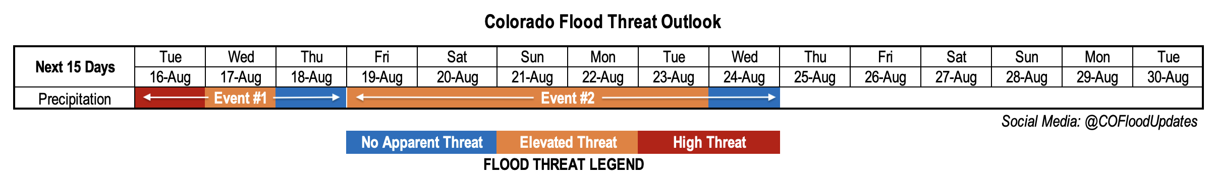
Valid Dates: 8/16 – 8/30
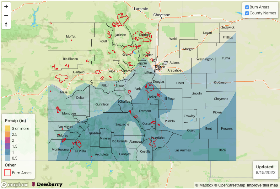
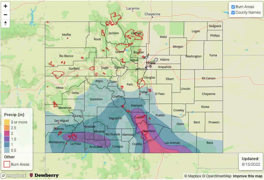
Today will mark the 66th consecutive day of precipitation somewhere across Colorado, with many of those days hosting at least isolated heavy rainfall. While we see some overall drying in the far longer-term (in consistency with climatological peak in moisture levels during early August), plenty of heavy rainfall and flooding concerns are still present in this Outlook, at least over the next 5-7 days.
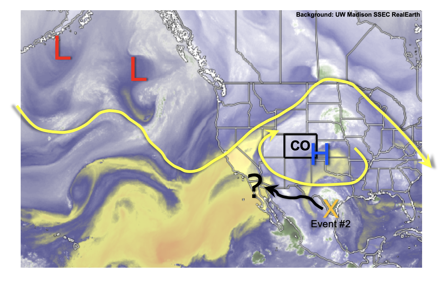
As seen in the water vapor image, below, the monsoonal upper-level ridge continues to occupy a familiar spot as throughout the summer: just southeast of Colorado. With the clockwise circulation around this ridge, a pulse of monsoonal moisture has managed to essentially rotate all the way around the Four Corners over the past 96 hours. This is a notable feat given that typically, at least some dry air impedes such large-scale movement. But in this situation, there is actually additional moisture being brought in from the north from a couple of frontal-type disturbances arising from the northeast Pacific. Today’s High flood threat (see Bulletin) will carry over into Tuesday as the moisture surge pushes southward (Event #1). Widespread heavy rainfall is anticipated over mainly southern and southeast Colorado, which will keep flash flooding chances especially high over the steeper terrain. By Wednesday, moisture will drop significantly statewide though the far southern and southwest border could still retain enough ingredients for a low-end flood threat. Calmer conditions are expected for Thursday as subsidence and moisture temporarily limit storms to the isolated variety.
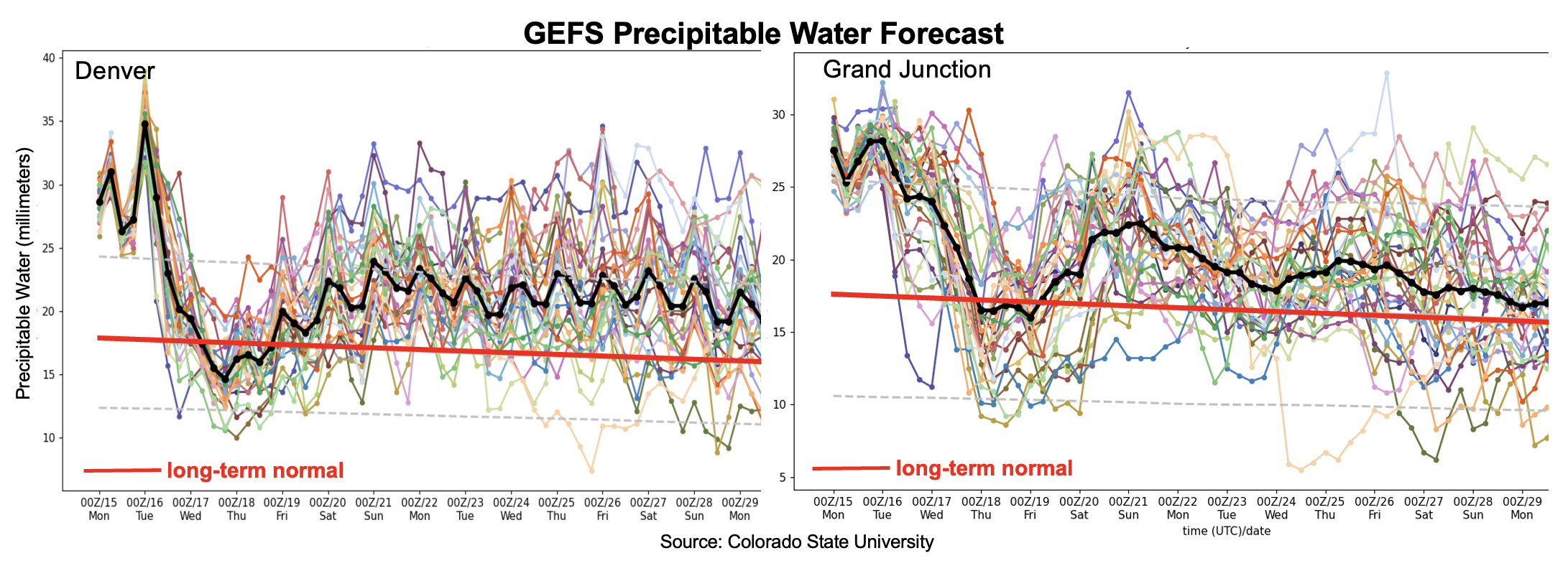
Things once again turn more active by Friday (Event #2) as the next pulse of monsoonal moisture takes aim at Colorado. This can be seen in both the Denver and Grand Junction forecast PW plumes, below. At least a low-end Elevated flood threat is anticipated, mainly for the higher terrain though some spillover onto the eastern Plains is possible. By Sunday, things turn quite interesting as the remnants of a moist tropical disturbance could send some significant moisture back into Colorado. There is large uncertainty with this outcome in the guidance, so only a low-end Elevated threat is anticipated at this time mainly along the NM border. However, if some of the newest guidance stays consistent, a higher flood threat could develop over southern Colorado, extending into the Southeast Plains. A widespread, heavy rainfall event could transpire by early next week over the US southern Great Plains, which would be excellent news given the recent dry weather there.
Temperature-wise, seasonably cool weather is thus expected statewide over the next 5-7 days amidst plenty of afternoon cloudiness and persistently cooler mid-level temperatures. Longer-term, the upper-level ridge is expected to eventually move to slightly northwest of Colorado, which would drop moisture a bit and provide seasonably warm and quieter weather. But given how this season has gone thus far, we are not yet ready to buy this solution!
The identified precipitation events are described in more detail below.
Event #1: Tuesday – Thursday (August 16 – August 18)
High Flood Threat Tuesday For Southeast Colorado, Then Downtick Through Thursday
Widespread heavy rainfall is expected for mainly southern and southeast Colorado on Tuesday. Max 1-hr to 3-hr rainfall amounts up to 2.5 inches and 4.0 inches are possible, respectively, with the most vulnerable areas being the Southeast Mountains, Raton Ridge and Southeast Plains. The flood threat will be highest over the steeper terrain though at least isolated flash flooding is likely to occur over the lower elevations of the Southeast Plains. At this time, it does not appear that rainfall duration will be long enough for a major riverine threat but smaller basins could experience some minor flooding.
By Wednesday, the heavy rainfall threat will shift along the New Mexico border with max 1-hour rainfall up to 1.5 inches possible.
Event #2: Friday – Wednesday (August 19 – August 24)
Elevated Flood Threat Friday and Saturday, With Significant Uncertainty From Sunday Onwards
A low-end Elevated flood threat is expected by Friday and Saturday for mainly the southwest, southern and central higher terrain. Max 30-min/60-min rain rates up to 0.9 and 1.4 inches will be possible, which could trigger flash flooding, debris slides and mud flows over steeper terrain. Lower elevation precipitation chance look limited at this time, but this could change.
By Sunday, depending on the aforementioned outcome of the tropical moisture position, a higher flood threat could emerge for southern and southeast Colorado. At this time, the “most likely” outcome is for a low-end Elevated flood threat for 30-60 minute duration heavy rainfall. The next Outlook should provide more detail on this situation, including whether or not a higher threat is warranted.