Issue Date: Thursday, July 18th, 2019
Issue Time: 2:10PM MDT
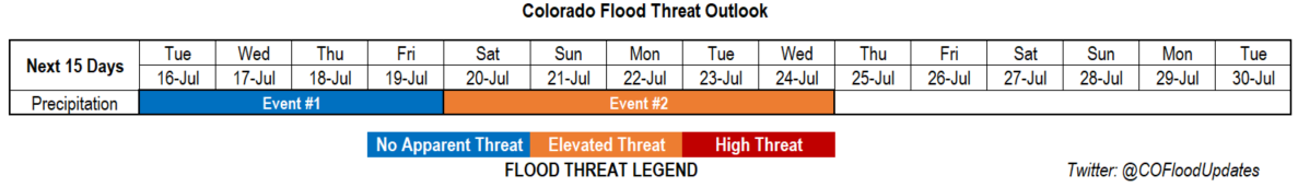
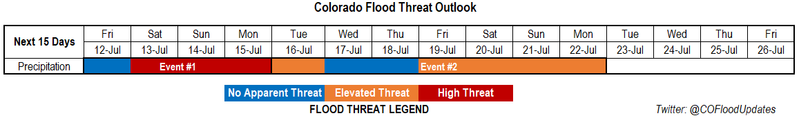
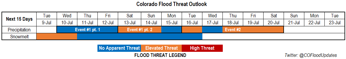
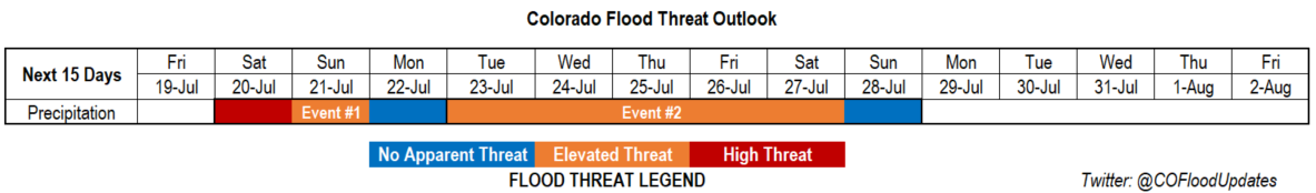
Valid Dates: 7/16 – 7/30
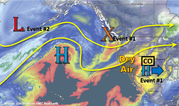
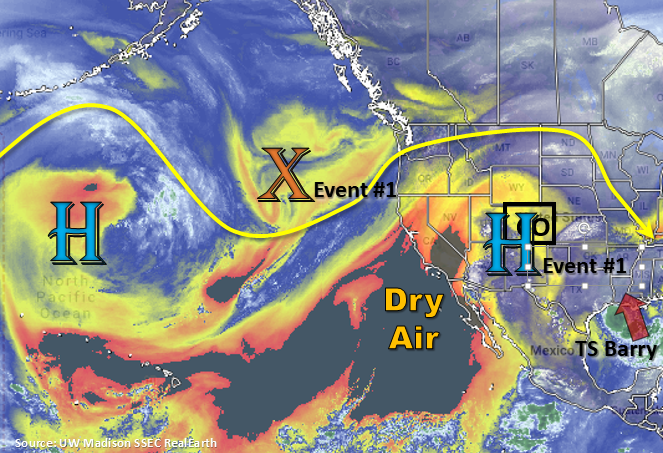
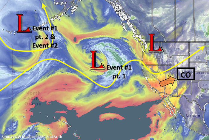
There is a two day break in rainfall statewide with some very hot temperatures forecast to start this FTO. Some relief from the heat will occur this weekend as a cold front, and increased moisture behind the front, will cause an uptick in thunderstorm activity (Event #1). Today, zonal flow aloft will continue to advect the dry air mass seen in the water vapor imagery below (yellow/orange) keeping conditions dry statewide. Flow aloft turns more southwesterly tomorrow as the ridge begins to build back to the west. A cold front is forecast to move through the state sometime between late Friday night and Saturday morning. Upslope flow in the moisture rich environment behind the front will return the flood threat to the eastern Colorado. High accumulations are possible due to the slow steering flows under the ridge. This will also help drop high temperatures by 15-20°F over eastern Colorado. The building ridge will also increase storm activity over the southwest corner of the state (mountains) by allowing moisture to meander northward. By Monday, the subtropical high moves into the four corners region, which will reduce the flood threat by pushing the higher moisture to our south and west.
Event #2 begins on Wednesday and Thursday over western Colorado. The upper level low (marked below) gets pushed eastward from another incoming upper low to its west. This will create a broader ridging pattern along with slight eastward movement of the ridge axis. By next weekend, the ridge over Colorado breaks completely down and high moisture moves from western Colorado into eastern Colorado.
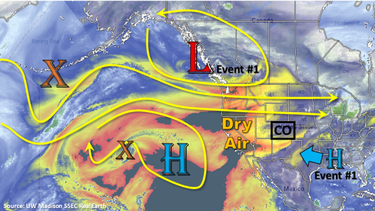
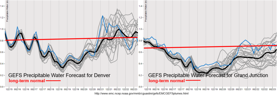
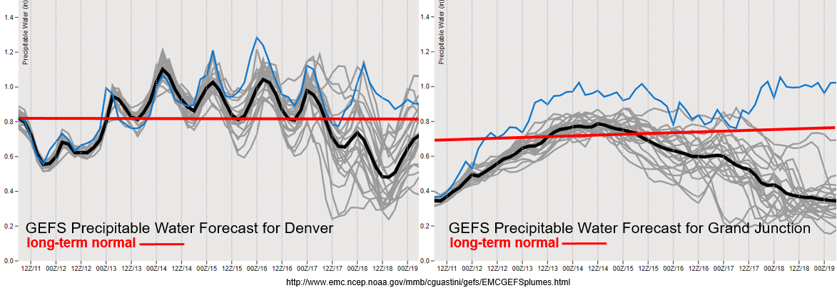
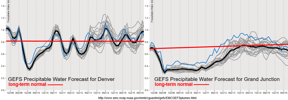
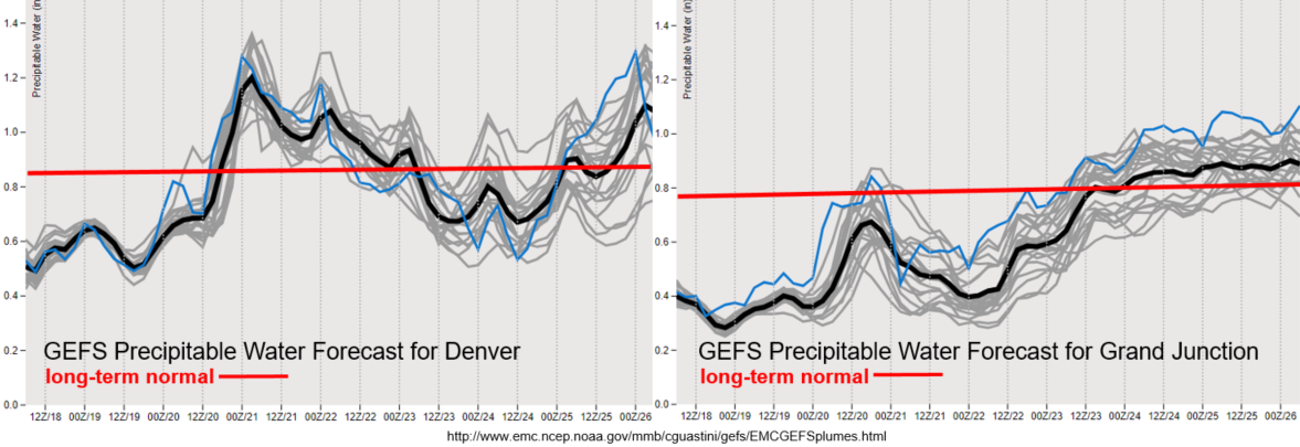
Well below average PW across the state for today and tomorrow. Behind the passing cold front, low level moisture has quite the return over eastern Colorado. Due to slow steering flows and high PW, a High flood threat has been issued. Reminder, this categorization means we expected to issue a threat higher than a Low flood threat in the FTB. Burn areas will need to be watched closely and there is also a chance for some nocturnal rainfall with post upslope flow. The front won’t affect temperatures over western Colorado, but a slight increase in moisture over the San Juan and Central Mountains is forecast, which would cause an increase in afternoon storminess. Additionally, the building ridge and increase in moisture will reduce fire danger. Going into next week, a more unsettled weather pattern is expected for western Colorado from Wednesday into the weekend. The monsoon looks to kick off at that time if models stay consistent with this forecast. The agreement in the plumes below (narrow space between gray lines) indicate the forecast isn’t expected to change much the next week.
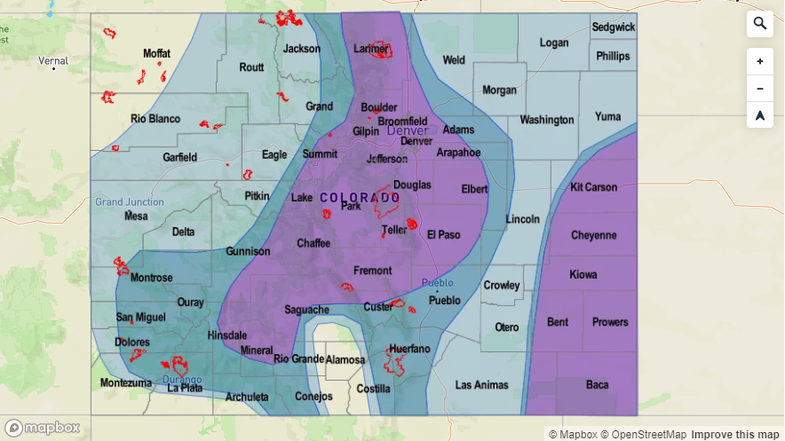
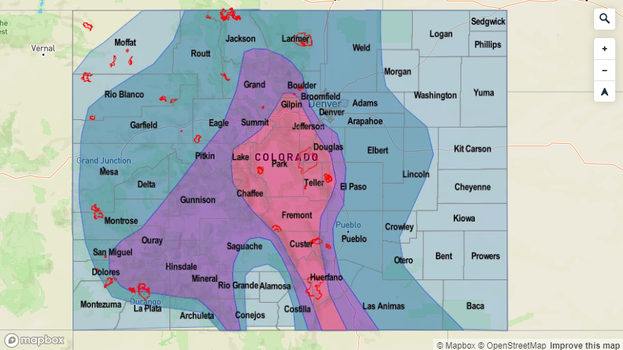
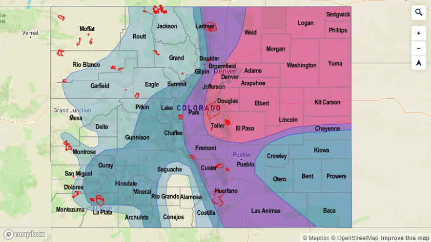
Event #1: Saturday (7/20) – Monday (7/22)
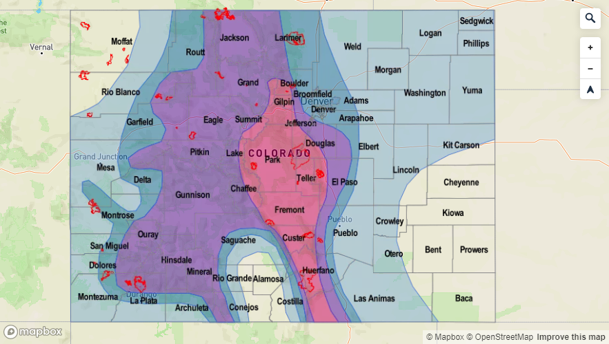
High/Elevated Threat as the subtropical high starts to build back to the west and a cold front returns moisture to eastern Colorado.
I think everyone is ready for a bit of a cool down, which eastern Colorado will receive this weekend. A little difference in timing between models, but sometime between late Friday night and Saturday morning a cold front will drop through eastern Colorado. This will cool temperatures off quite a bit and increase storminess with post frontal upslope flow. There is a High flood threat for the eastern mountains and immediate adjacent plains. Burn scars will be particularly susceptible with slow steering winds and a moisture rich environment slowing for high rain rates. Mud flows, debris slides and flash flooding will be possible over burn areas and steeper terrains. Decent CAPE over the immediate adjacent plains may cause a severe thunderstorm or two with the main threats being hail, strong winds and heavy rainfall. The eastern plains look to remain capped, so unless there is a strong shortwave moving through (lifting mechanism), not expecting storms over this area. The best chance for eastern plain storms will be along the Raton Ridge where increased convergence may allow a storm or two to traverse farther east. Sunday, conditions looked to be a little more capped as well, but with such weak steering flows, storms will still be capable of producing totals that may cause flooding issues over the mountains and burn areas. Thus, the Elevated flood threat.

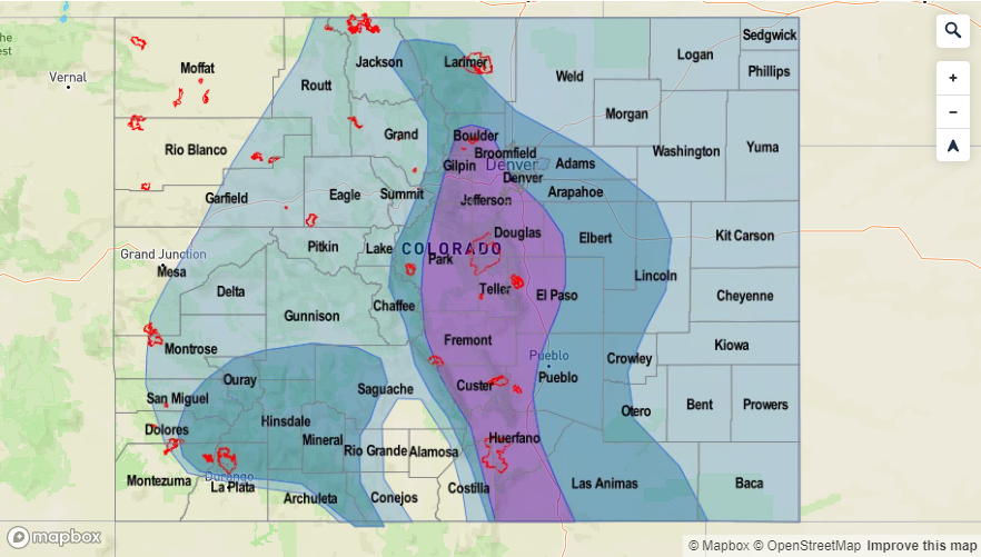
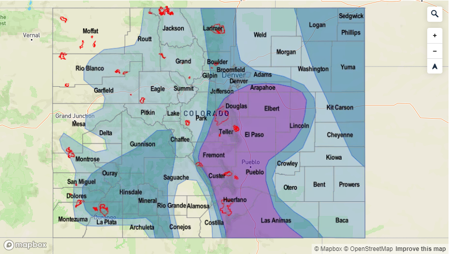
Event #2: Tuesday (7/23) – Sunday (7/28)
Elevated Threat as the monsoon kicks off with the threat starting over western Colorado and moving east.
If the models stay on track, the true monsoon looks to kick off by mid-next week. So a little bit of a late start, but no records for a late start have been broken yet. There is an Elevated flood threat over western Colorado as a PW surge begins early next week. The surge extends to the north, so there should be an increase in storms over the Northern Mountains as well. Burn areas are the main concerns (Lake Christine and 416), but there may also be a threat over the San Juan Mountains. An eastward shift in the ridge axis on Thursday allows moisture to rotate around the high into eastern Colorado. Elevated PW values and slow steering winds should keep the flood threat around through the weekend. Tune back into the FTO on Monday for the latest.