Issue Date: Monday, July 15th, 2019
Issue Time: 1:40PM MDT
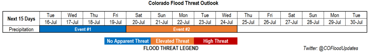
Valid Dates: 7/16 – 7/30
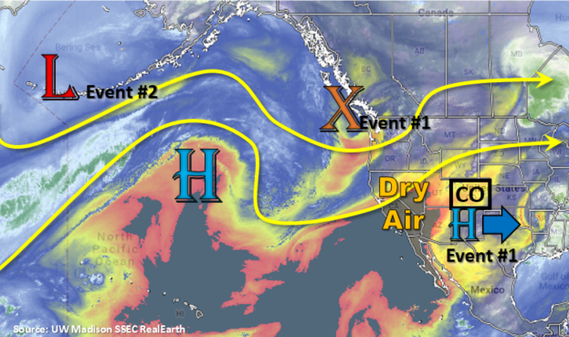
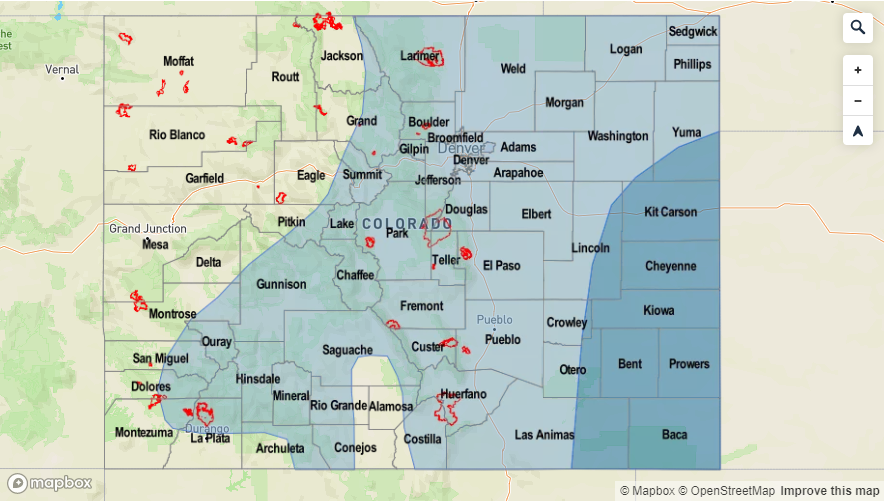
One more day with upper level ridging over the state before the shortwave trough (orange “X”) moves eastward and creates more zonal flow over the forecast area (Event #1). The approaching trough will push the subtropical high eastward and more westerly flow will begin to advect dry air into the state from the west. As far as shower and thunderstorm action, tomorrow looks to be the last day with widespread showers and thunderstorms. Moisture is expected to continue to decrease, so storms will be more isolated than today. Outside of some possible storms over the far southeast corner of the state on Wednesday, models aren’t showing much (if any) rainfall for Thursday and Friday. Temperatures will start to near the triple digit mark during this event across all the lower elevations, so be prepared for some hot temperatures Wednesday through Friday. Fire weather concerns return on Tuesday for the Northwest Slope. The jet will brush this area as the trough moves east and a tightening gradient could mix some strong surface winds to the surface both Tuesday and Wednesday afternoon.
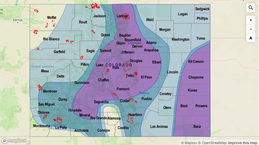
Going into this weekend, the ridge begins to build back over the state. Strong southwest flow aloft across the state will create another PW surge on the west side of the high pressure system. By the end of this weekend into early next week, the high looks to center itself over the New Mexico and the Texas Panhandle. This is a favorable pattern for a PW surge both east and west of the Continental Divide. Therefore, there is an Elevated Colorado flood threat for Event #2 with the threat extending to recent burn areas. As the upper low marked in the image below moves east, a trough will push east and flatten the ridging pattern. This will likely bring another statewide break in heavy rainfall sometime at the end of next week.
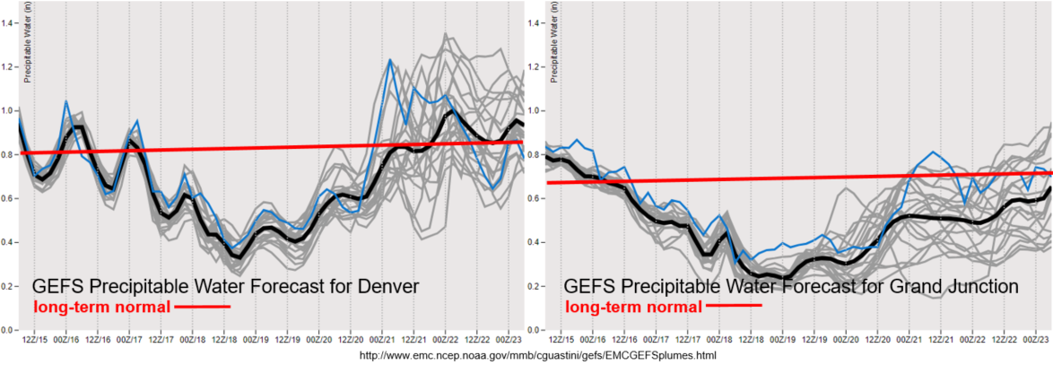
The dry air mass seen in the water vapor imagery above has already begun to move into western Colorado. PW drops off to significantly below climatology by Thursday both east and west of the Continental Divide. Better moisture holds on over eastern Colorado on Tuesday, but storm chances look to decrease when compared to today. The GFS and NAM indicate some CAPE over the eastern plains on Tuesday, so it is possible for some stronger thunderstorms over this area during the late afternoon and evening. The main threats will be severe hail and gusty outflow winds with moderate rainfall. By Sunday night, the GEFS indicates a cold front moving through the state. If this occurs, it would cool off high temperatures and increase low level moisture for an uptick in storm activity on Monday. Models are quite uncertain with moisture return over western Colorado for Event #2, which is related to the placement of the subtropical high/ridge axis and moisture advection around the west side of this feature.
Event #1: Tuesday (7/16) – Friday (7/19)
No Apparent Threat as flow becomes more zonal and advects a dry air mass into the state from the west.
Active weather for one more day before the atmosphere really begins to dry out with the zonal flow. Storms will likely be more isolated in nature tomorrow, although if they are able to make it to the eastern plains before dissipating, some stronger thunderstorms may be possible. Not anticipating a lot of flooding issues over the higher terrains during this event, but burn scars over the Southeast Mountains may be under a flood threat tomorrow. Be sure to tune back into the FTB for the latest tomorrow morning. The main threat for this period will be hot temperatures with triple digits anticipated as early as tomorrow for western Colorado. There is a Fire Weather Watch for the Northwest Slope for Tuesday and possibly Wednesday, so use caution with open flames. Southwest winds in the 10 to 20 mph range are forecast with gusts in the 35 to 40 mph range.

Event #2: Saturday (7/20) – Wednesday (7/24)
Elevated Threat as zonal flow becomes more southwesterly with a building ridge and the next PW surge occurs statewide.
Lower confidence in the timing for the main threat for Event #2, although confident there will be another PW surge northward during this period. Zonal flow should turn more southwesterly as a ridge begins to build back over the state, which will increase moisture across the area. Should the high set up over NM/TX, a large PW increase statewide would be possible. Slow steering winds under the ridge would cause storms to have large accumulations similar to the event that occurred this weekend. Rotating shortwaves, if timed correctly, could help increase coverage with the diurnal flow, though it is too far out to identify these features. The GFS has a cold front moving through the state later this weekend. Increased upslope flow and moisture behind the front would cause an Elevated flood threat to start next week. It would also likely allow storms to develop over the eastern plains with some early morning fog and cloud cover. Please tune back into the FTO on Thursday as details will continue to change over the next several runs.