Issue Date: Thursday, July 11th, 2019
Issue Time: 3:00PM MDT
Valid Dates: 7/12 – 7/26
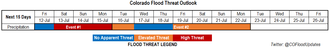
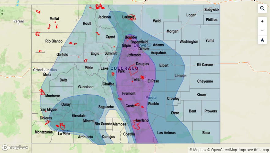
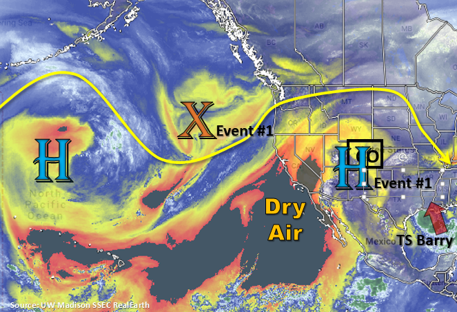
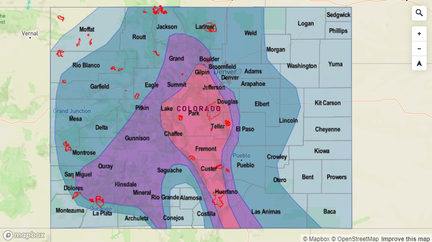
The water vapor imagery below denotes two features that will cause a High flood threat to be issued for Event #1. The first is the subtropical high, which is currently hanging out near the Four Corners region. The 500mb upper trough, marked below with an “X”, will position itself off the Pacific Northwest coast by this weekend. This will push the ridge axis to the east and allow a PW surge northward statewide. The surge will last west of the Divide through Sunday, and it will last through Monday/Tuesday to the east. With multiple days of heavy rainfall possible, soils may become saturated and increase runoff. The placement of the high over CO/NM will limit steering winds, which will also help large rainfall totals accumulate. Starting on Saturday, recent burn areas will need to be monitored closely.
From Tuesday to next Monday (Event #2) there is still some uncertainty in the forecast, but the GEFS is producing a weak ridging pattern over the state once again by the end of the week. A trough to our west may help keep the ridge axis to our east, which if this happens, would produce another PW surge statewide. The placement of the 500mb high each day will be key, since this will determine where the highest moisture (advecting clockwise around the 500mb high) will set up. Slow steering winds again will cause an Elevated flood threat to be issued, which includes recent burn areas. With the weaker atmospheric pattern, there will likely be changes model run to model run, so tune back into the FTO on Monday for the latest on trends from the runs.
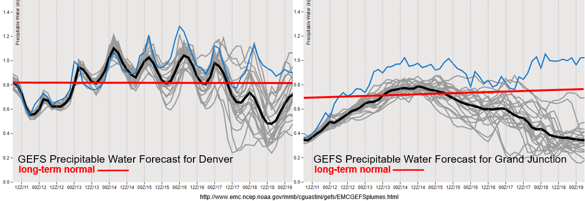
Quite the ramp up in PW from the GEFS from Friday into Saturday. By Saturday evening, PW looks to remain above an inch over eastern Colorado through (possibly) Tuesday. For western CO, PW values are above climatology this weekend before models start to show a drop off in moisture. Expecting widespread showers over the western high terrains with an increase in activity over the adjacent valleys. The models likely show a drop off in PW values due to advection of dry air from the west, which will scour out moisture and place higher PW values to the south/west. Wednesday and Thursday look to be mostly dry for western Colorado with more isolated afternoon storms possible on Tuesday afternoon. Same goes for eastern Colorado. Storm activity is forecast to decrease Wednesday and Thursday, so this should give us a break in widespread rain before the start of the next weekend (July 20-21; Event #2).
Snowpack/Riverine:
Peak flow from snowmelt this season has passed. That means for this weekend, flows are forecast to decrease statewide from decelerating snowmelt rates. This does not mean that rivers and streams will not be running high, so please use caution around rapid, flowing water. With heavy rainfall returning to the forecast for multiple days, some Minor flooding may be possible if storms track over the same areas more than one day in a row. Increased runoff would be expected in this case due to saturated soils. Please track the daily flood threat in the FTB and follow your local NWS office for all Flood/Flash Flood Warnings/Advisories. Note that all active riverine Flood Warnings and Advisories (at the time of the post) will be mentioned in the FTB.
Event #1: Friday (7/12) – Monday (7/15)
High Threat/Elevated Threat as the ridge axis slides east and a PW surge occurs statewide.
Active weather weekend ahead with the eastward shift of the ridge. By Saturday, widespread showers and thunderstorms will likely produce flooding. A weak surface trough on Saturday may cause some storms to become severe over the eastern plains with the main threats being large hail and strong winds. Overnight rainfall may also be a concern on Saturday night, but this of course depends on the timing of shortwaves moving through the area. These small features are better forecast on a 24-hour scale. A stronger surface trough sets up on Sunday, so the risk for severe weather is a bit higher. Slow steering winds will cause heavy rainfall concerns with possible riverine flooding in the high country. Flows are still quite high from snowmelt and dam releases. Burn areas will also be under the gun with debris slides, mud flows and flash flooding being the main threats for storms that track directly over a scar. Once again FTB will be watching and tracking shortwaves rotating around the high as well, as this would help enhance convection and may cause more widespread activity over the eastern plains if they are timed with peak heating. Overall, we’re in for a wet weekend, and be sure to get off the high peaks early as the monsoon kicks off thunderstorms by the early afternoon.

Event #2: Tuesday (7/16) – Monday (7/22)
Elevated Threat/No Apparent Threat as zonal flow becomes more southwesterly with a building ridge.
Once again, lower confidence in this forecast. Zonal flow at the beginning of the week should decrease the flood threat, especially to the west as dry air becomes entrained from the desert southwest. More isolated storm activity is expected by the middle of the week even though there is still some spread in the PW plumes after this weekend. The next ridge sets up by Friday, which may cause another PW surge from the south and east. Paired with slow steering winds, an Elevated flood threat has been issued. Please tune back into the FTO on Monday as details will continue to evolve and alter the forecast.