Issue Date: Monday, July 8th, 2019
Issue Time: 2:10PM MDT
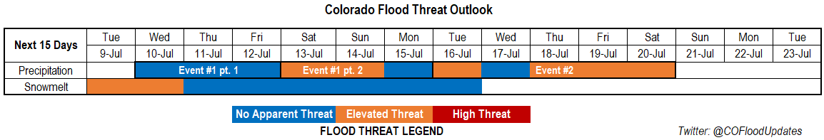
Valid Dates: 7/5 – 7/19
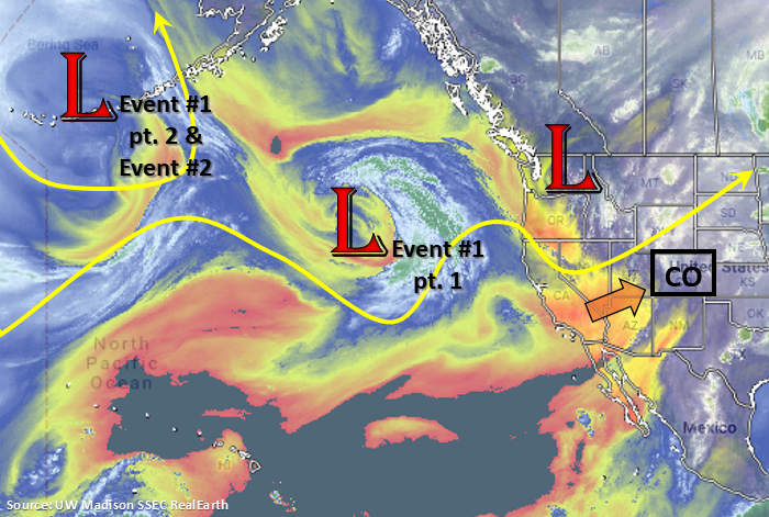
Busy pattern over the Pacific ocean with multiple low pressure systems tracking from west to east during this next FTO. Expect some very hot temperatures this week under the riding pattern beginning tomorrow. Currently, a low is over the Pacific Northwest and it will continue to track eastward today and tonight. Behind that low, southwesterly and westerly flow aloft will pull in the dry air mass seen near the Four Corner region. This will lower PW values across Colorado and give us a break from afternoon rainfall tomorrow. Event #1 begins on Wednesday as the ridge begins to build back to the west and centers its axis over Colorado. The low, marked below, moves east and settles off the coast of WA/OR. The upper level system splits with half the energy moving east and the other half back to the west on Thursday and Friday. This will slide the ridge slightly to the east and start to return some low level moisture east and west of the Divide for scattered storms at the end of this week. The next low then forms over the same area (off the coast of WA/OR; Event #1 pt. 2) and a high pressure over NM/CO rotates some moisture back into the state for an Elevated flood threat this weekend.
From Tuesday into next weekend, a stronger low pressure systems moves into the Gulf of Alaska. This would place the ridge axis in a favorable location for another moisture surge from the Gulf and Pacific over the state. Models are showing the correct placement of the high for this system, so this will likely mark the beginning of the 2019 North American Monsoon (NAM).
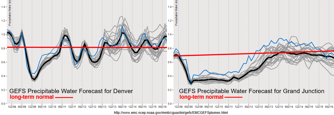
Looking at the GEFS PW plumes below, you can see that very dry air mass being entrained to the westerly flow aloft after this afternoon (west) and this evening (east). Note, this is the time of year we start to see a spike in the PW climatology with the onset of the monsoon, so the long-term normal has increased since the last FTO. There is a good moisture return over eastern Colorado by Wednesday, which likely has to do with a weak cold front that passes through Tuesday night. Moisture, and thus storm chances, don’t return to the forecast until Friday over western Colorado. As for this week, the jet is expected to brush the northern border tomorrow afternoon with the passing trough, so critical fire weather may be possible over the Northwest Slope. Both GEFS PW forecasts hover around climatology through this weekend into next week, so expecting widespread storm activity to return to the state Friday with activity increasing over the plains this weekend. Light steering winds under the ridge will allow higher accumulations, so the threat will return to recent burn areas as soon as Friday.
Snowpack/Riverine:
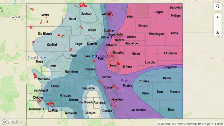
It seems like all basins have reached their peak flow from snowmelt this season. So expecting rivers to remain high through the middle of this week. Warm temperatures will continue to chip away at the remaining snowpack and dam releases and diversions may cause some extra elevated flows. The main threats will be Minor flood over low lying spots along the river, which may flood pedestrian paths and trails. Over the SLV, flows are forecast to decrease throughout this week, so flooding chances decrease after Tuesday. With no major rain events forecast this week, rivers are not anticipated to swell from extra runoff. It will be possible for some minimal rises in smaller streams should an afternoon storm track over these areas on Friday into this weekend, but no major riverine flooding is forecast. For the latest on the riverine flood threat and dam releases/diversions, check out the real-time AHPS gage heights and follow your local NWS office for all Flood Warnings and Advisories. Note that all Flood Advisories and Warnings will be mentioned in the daily FTB (active at the posting time).
Event #1: Wednesday (7/10) – Monday (7/15)
No Apparent Threat/Elevated Threat as a series of shortwaves and upper troughs move west to east and displace the ridge.
Should be quiet for the most part this week with some very warm temperatures over the state as the ridge builds north. High temperatures are expected to reach the 90°Fs over the adjacent plains with 100°Fs possible as early as Thursday and Friday over the eastern plains and Grand Valley. Wednesday storm activity should be limited to the high elevations although a couple stronger storms may be possible over the southeast corner of the state along a moisture boundary. Only moderate rainfall is anticipated, so at this time there is No Apparent Threat. Friday, the threat should remain over the mountains with only scattered, weak afternoon thunderstorms expected. By Saturday there is an Elevated flood threat as a high over AZ/NM pulls in better moisture to the state. PW values over the eastern plains are between 1 and 1.3 inches by Saturday afternoon. With slow steering winds, a passing shortwave and high moisture, heavy rainfall is forecast. Not much change for the forecast on Sunday, so that should be a rinse and repeat pattern, but the bulk of the activity is anticipated to remain over the mountains. Scattered afternoon showers are forecast again on Monday, but with less moisture available, the threat has been reduced. This may change by Thursday, so tune back into the latest FTO.

Event #2: Tuesday (7/16) – Saturday (7/20)
No Apparent Threat/Elevated Threat as the monsoon begins to set up.
With the forecast this far out, there is still quite a bit of uncertainty as details will evolve and change, especially with timing and magnitude. But it looks like the monsoon will begin to set up with models setting up the high over the correct location. There will likely be a break in heavy rainfall on Wednesday before the next moisture surge north occurs. Models aren’t placing the center of the high in a location that promotes maximum PW advection into the state, but the location of the high should increase the chances for heavy rainfall across the state. The maximum northward pull of moisture on the west side of the high looks to set up to our west, but PW values should increase over the southwest corner into central Colorado. Over eastern Colorado, northwesterly flow on Thursday should push the higher PW values to our east. However, by the weekend surface winds from the southeast are expected to start advecting a very moist air mass back into the state. Thus, the Elevated flood threat.