FTO 08-01-2019: 2019 Monsoon Causes an On and Off Heavy Rainfall Threat through Next Week

Issue Date: Thursday, August 1st, 2019
Issue Time: 2:50PM MDT
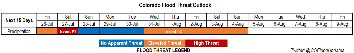
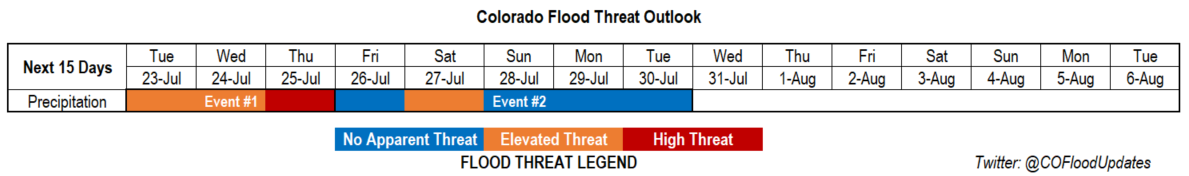
Valid Dates: 8/2 – 8/16

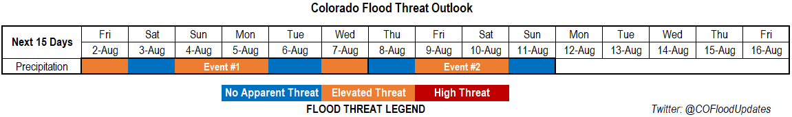
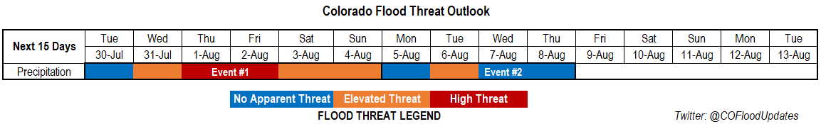
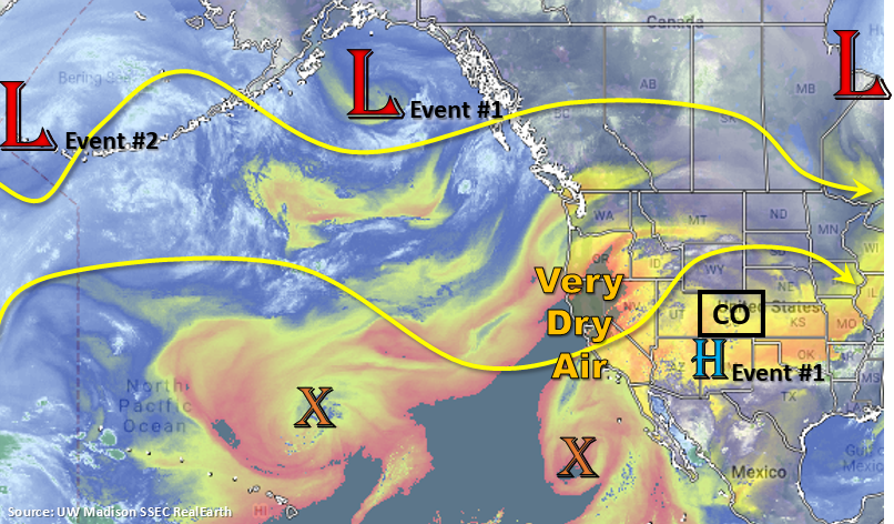
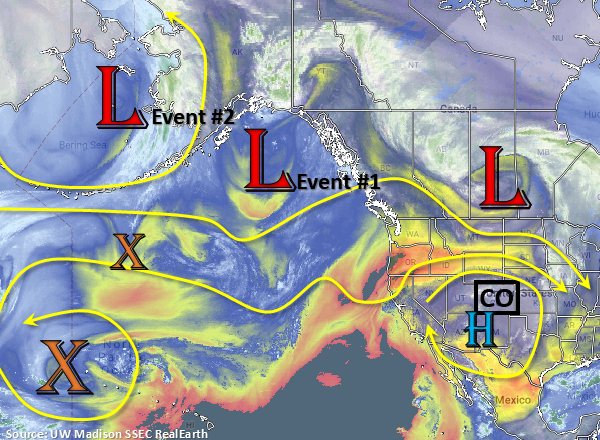
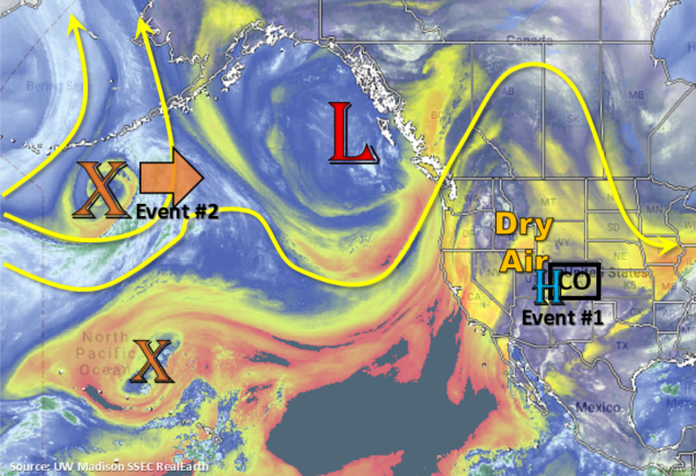
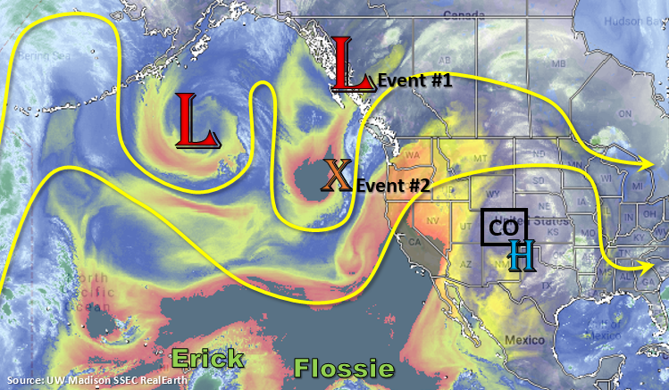
There is an Elevated flood threat for both events of this FTO with breaks in heavy rainfall forecast every couple of days. Monsoon season is well underway, and since we are at the peak of climatological PW values, the active pattern is not surprising. By tomorrow, the subtropical high shifts to the west over the four corners regions, which essentially cuts off the PW flow over western Colorado limiting afternoon rainfall to scattered showers over the higher terrains. We will watch for any subtropical moisture sneaking into the southwest corner of the state (dependent on the placement of the high) as this could cause high enough rain rates for flooding issues over the 416 burn area. Post frontal upslope flow behind the front over the southeast corner of the state tomorrow may cause some flooding issues for recent burn areas over the Southeast Mountains, thus the Elevated flood threat. From Sunday into Monday, the ridge weakens with a passing trough. This will push a weak cold front through the state on Monday, which could trigger some heavy rainfall and a few severe thunderstorms over eastern Colorado. The eastern plains look to remain capped on Tuesday minus over the mountains where storms will initiate again with upslope flow. Not seeing a flood threat at this time, although details could easily change over this weekend.

For Event #2, the next northward monsoon push begins on Thursday. Not looking quite as strong as the current one, so at this time thinking coverage of the heavy rainfall threat will be less. Nonetheless, there will be an Elevated flood from Friday into Saturday. The low begins to move onshore next weekend, and once it moves through, more zonal flow is anticipated. This pattern typically pushes the high moisture to the east and suppresses the monsoon surge.

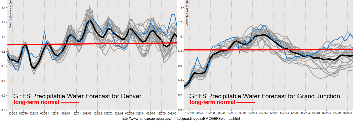
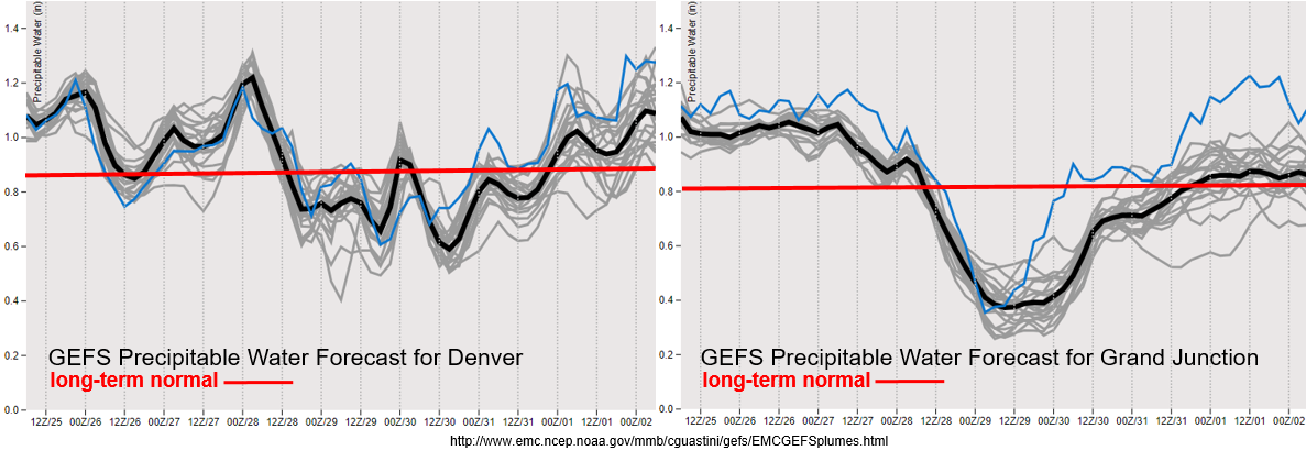
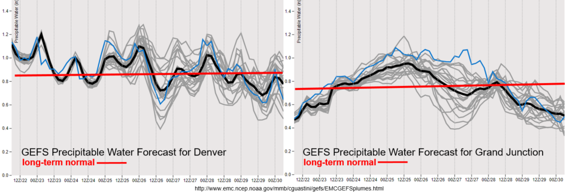
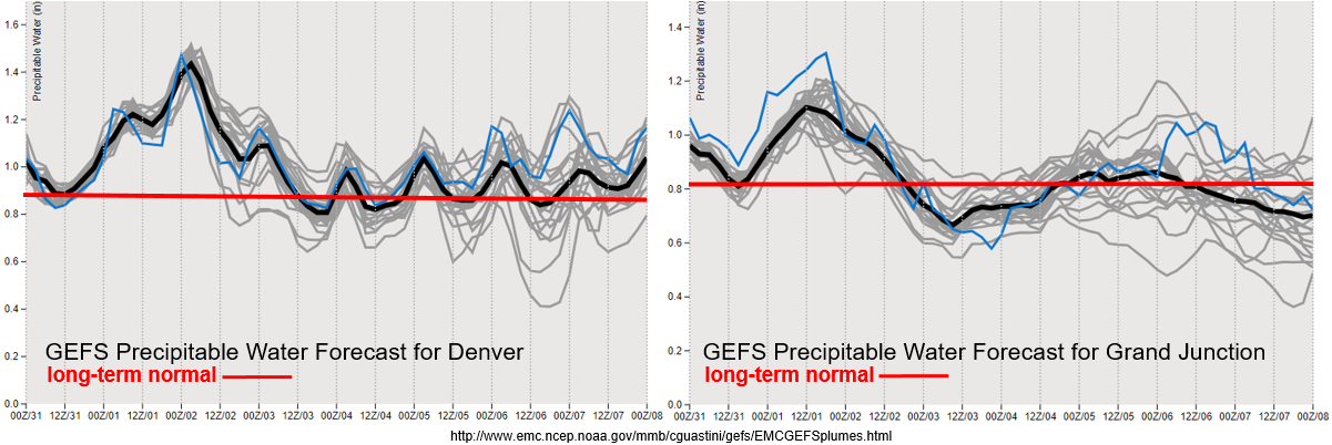
The GEFS moisture plume page hasn’t been updated yet today, so the image below is a little old. You can see the current PW surge, which peaks this evening. After this event, it looks like average PW through next Wednesday. Note the scale on the left (DEN) is slightly different than on the right (GJT). The slightly elevated levels of PW over eastern Colorado tomorrow may cause some heavy rainfall over the Southeast Mountains/Raton Ridge, but there will overall be a downtick in coverage and intensity through next Wednesday when compared the last couple of days. The burn areas over the Southeast Mountains will be watched carefully tomorrow for a flood threat, but elsewhere this time, thinking rain rates will be gradual enough to avoid flooding issues.

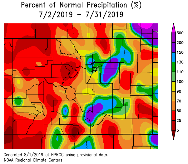
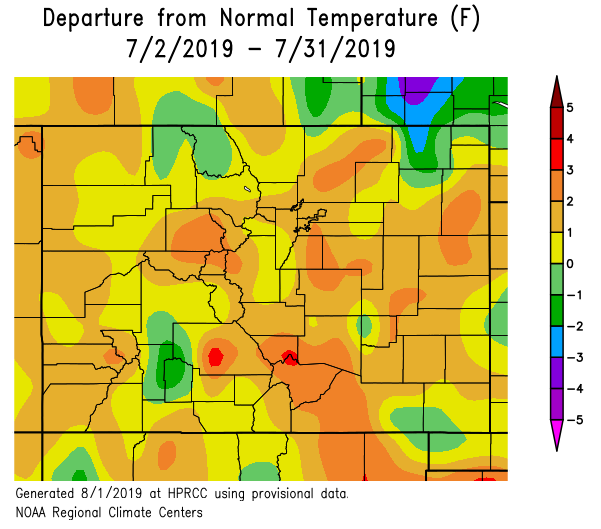
Below is a recap of the July’s temperature and precipitation. It was noted in the last couple of FTOs that the onset of the monsoon was a little slow this year. However, the majority of eastern Colorado received more than average rainfall with the 200-300% percent of normal area equating to about 2-3 inches. A bit drier back to the west, although it is important to note that August is their big rainfall month. Their 25-50% of normal precipitation equates to no more than 1 inch below normal. This below average rainfall did cause the D0 (Abnormally Dry) drought to be placed back on the drought monitor map over the northwest and southwest corners of the state. As far as temperatures, quite the turnaround from May and June, which were very cool. Most of the state was 1 to 3°F above normal with a couple of notable stretches of upper 90°Fs to 100°Fs. This put the cooling degree days (base 65°F) between 60-80% higher than normal along the Urban Corridor and the adjacent plains of the Southeast Mountains.

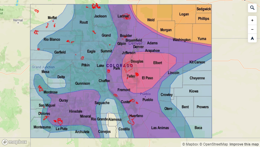
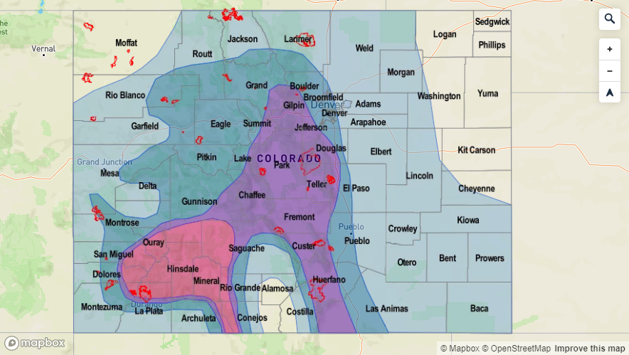
Event #1: Friday (8/2) – Wednesday (8/6)

Elevated Threat as the subtropical high shifts into the Four Corners Region and a cold front drops through the state on Monday night.  

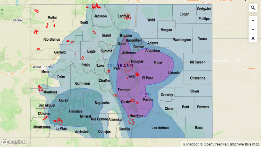
On and off again moisture, but the threat for Event #1 is mostly over eastern Colorado and the mountains. There may be an Elevated threat over the 416 burn area on Sunday, but the placement of the high/strength of the ridge will be key (determines if the moisture can meander north). Monday to Wednesday, the threat moves into the eastern plains. This is especially true on Wednesday when the passing shortwave will help support thunderstorms over the plains and cause steering flows to have more of a westerly component as it breaks down the ridge. Not seeing any huge moisture surges, so an Elevated threat should suffice with a lee trough setting up from Monday to Wednesday. Of course if a passing shortwave teams up with peak heating while moisture is elevated, there may need to be a Moderate flood threat issued.

Legend


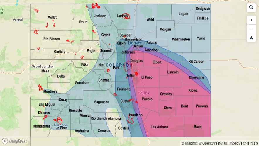
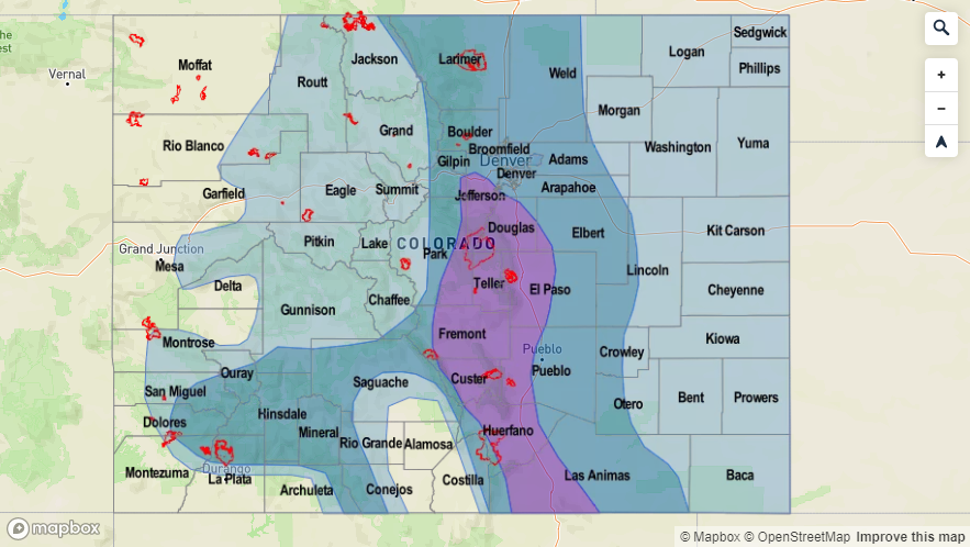
Event #2: Thursday (8/8) – Sunday (8/11)

Elevated Threat as the ridge begins to rebuild before being shifted east causing the next moisture surge.

The ridge begins to build again during Event #2, and the axis will event slide east causing the next monsoon moisture plume to move northward when a shortwave moves through. The PW values look to peak on Friday and Saturday right now, thus the Elevated flood threat during this time frame. Lower confidence in this solution over western Colorado than eastern Colorado as well. Should be a fairly rapid event with the just brushing the northern border. This will also keep steering flows faster, which should limit rainfall accumulation.

Legend

FTO 07-29-2019: Short Break from Heavy Rainfall Before the Next Statewide Monsoon Surge

Issue Date: Monday, July 29th, 2019
Issue Time: 3:00PM MDT
Valid Dates: 7/29 – 8/13

There is an Elevated/High flood threat for Event #1 of this FTO. As the high pressure slightly moves west into the TX panhandle Tuesday into Wednesday, the next monsoon PW surge occurs. The incoming low pressure system marked below is the instigator in the shift of the ridge axis to the east. Lee troughing will also help pull low level moisture northward over the eastern plains beginning on Tuesday afternoon. A cold front looks to drop through the state on Thursday, which often returns low level moisture, so a High flood threat is issued for post frontal upslope flow and overnight precipitation along the boundary over the Northeast Plains. The High threat continues on Friday, although the afternoon storm activity should be more of a mountain and adjacent plain flood threat due to capping over the plains. An Elevated flood threat continues through the weekend with the San Juan Mountains under the gun for western Colorado. Burn areas will be monitored daily throughout the event in the FTB.

For Event #2, the next trough digs south farther west than the last handful of systems. If this occurs, this will pull the subtropical high back to the west and put the state under more northwesterly flow aloft. Still lower confidence in the forecast this far out, but we will discuss it more nonetheless. This pattern would keep cooler temperatures in the forecast and prevent any long duration PW surges northward into the state. There is an Elevated flood threat on Tuesday in this scenario due to post frontal upslope flow. Faster steering winds should keep the threat over an limited area, but more of a westerly component to the steering flows would likely cause some rainfall over the eastern plains favoring the Southeast Plains, Palmer Ridge and Raton Ridge.

The next monsoon surge is quite visible in the GEFS PW plumes below (Event #1). By about Wednesday, PW values start to reach above climatology over eastern Colorado. This again is aided by a lee surface trough setting up on Tuesday. PW also creeps up over western Colorado by tomorrow night. So expect an increase in activity over the high country from Wednesday into Friday. The high then shifts into an unfavorable location for western Colorado rainfall and PW drops off drastically. Still some uncertainty in the forecast (west) after this weekend, but PW looks to remain at or just below climatology. So other than recent burn areas, the flood threat is anticipated to decrease.

Event #1: Tuesday (7/30) – Sunday (8/4)

High/Elevated Threat as the subtropical high shifts in to the Texas Panhandle and the next PW moisture surge begins.  

Should have one more quiet day with limited afternoon storm activity before the next monsoon surge begins. By Wednesday, PW values start to edge above climatological values, which should increase storm coverage during the afternoon. Expecting western Colorado to be impacted first with the threat moving east on Thursday. A passing cold front overnight on Thursday may cause some nocturnal thunderstorms capable of producing some very heavy rain over the northern Urban Corridor and western portion of the Northeast Plains. Post frontal upslope flow will likely impact and cause heavy rainfall over the southern Front Range, Southeast Mountains and San Juan Mountains on Friday. This is probably the day that needs to be watched closest for flooding over recent burn areas. Rain continues Saturday over the high terrains with some thunderstorms also possible over the Colorado/Kansas border. Weak thunderstorms are forecast each of the afternoon with a couple of severe storms possible over the eastern plains. The severity of the thunderstorms will likely be determined by passing shortwaves. If timed with peak instability, a couple of severe thunderstorms may be possible with some large hail.

Legend

Event #2: Monday (8/5) – Thursday (8/8)

Elevated Threat/No Apparent Threat northwest flow aloft returns and shuts down rainfall activity over western Colorado.

Shift in the overall monsoon pattern if the GFS is right. The next low pressure system looks to dig south and west of California for this event. This would pull the subtropical high to our west and put eastern Colorado under northwest flow. It would really limit afternoon rain over western Colorado minus some weak storms and showers over the Central and San Juan Mountains. Cooler temperatures also look likely to start next week, which will be a nice break from the heat. A cold front may also be possible on Monday night, which could cause some heavier rainfall over the southeast quadrant of the state on Tuesday. This includes the Southeast Mountains and recent burn areas. However, higher PW values would quickly be pushed south and east under the flow aloft. This would only support scattered showers on Wednesday and Thursday capable of producing only light to moderate rain rates.

Legend

FTO 07-25-2019: Heavy Rainfall and Widespread Thunderstorm Activity Anticipated to Start this Weekend

Issue Date: Thursday, July 25th, 2019
Issue Time: 2:50PM MDT
Valid Dates: 7/26 – 8/9

There is an Elevated/High flood threat to start this FTO, which is due to the location of the subtropical high tomorrow and then incoming upper level low on Saturday (Event #1). While most of eastern Colorado will begin to dry out tomorrow with flow aloft from the northwest, the Elevated flood threat continues for the southwest high terrains where flow aloft remains more westerly. Three days of rain over this area has likely saturated parts of the soil, so expecting an increase in runoff from storms tomorrow afternoon. On Saturday, the incoming trough (marked below) pushes towards the east and shifts the ridge with it. Meanwhile, the subtropical high moves into California/Arizona/southern Nevada, which will eject a fairly strong shortwave over the state for more widespread thunderstorm coverage and possibly an overnight MCS on the plains. There is a break in the heavy rainfall threat from Sunday into Tuesday, although there will likely be enough residual moisture for scattered storms to trigger over the mountains each afternoon. A passing cold front on Saturday night/early Sunday morning is expected to reduce highs 2-5°F over eastern Colorado on Sunday and Monday.

The next northward monsoon surge begins on Wednesday, and an Elevated flood threat will be issued for Event #2. The ridge begins to build back to the north with the center of the subtropical high centered somewhere near the Colorado/New Mexico/Texas Panhandle. There will likely be several shortwaves rotating around the high, which will cause the increased threat level as the next trough pushes the ridge axis east. Decreased steering winds under the high will cause storms over the higher terrains to produce more rainfall as well. In this classic monsoon setup, flooding may be possible each afternoon, although the area of the threat is anticipated to change day to day. The ridge looks to break down with the high moving west sometime to start that next week, resulting in a break for the heavy rainfall threat.

Reaching that point in the season where PW values are climatologically peaking, which means the above average values shown below are very impressive. Slight decrease in moisture over eastern Colorado tomorrow with flow aloft changing to the northwest and pushing in a little drier air from the north. Doesn’t take long for the values to increase again on Saturday night with south and southeast winds at the surface pulling in high moisture. To the west, above average moisture is forecast for western Colorado through Saturday. This will keep the flood threat around, especially with multiple days of rainfall in a row. PW drops statewide as the high builds over the southern Colorado border Sunday through Tuesday. Moisture then looks to return to more seasonal values mid-next week with the strengthening high pressure, associated building ridge and slight eastward placement of the ridge axis.

Event #1: Friday (7/26) – Sunday (7/28)

High/Elevated Threat as a shortwave combines with a PW moisture surge.  

A strong lee trough looks to set up on Saturday, which will provide ample lift for afternoon storms in a moisture rich environment across the state. Best instability right now looks to be over the southern high terrains/Raton Ridge and the Northeast Plains/Palmer Ridge. Won’t be surprised if there are couple severe thunderstorms on Saturday across the plains with the main threats being large hail (up to 1.5 inches), heavy rainfall and gusty winds. Storms on Friday and Saturday will be problematic if they track over recent burn areas. Watching the 416/Spring Creek burn area on Friday and all recent burn areas listed on the help page on Saturday. A passing cold front overnight on Saturday and decrease in moisture should keep afternoon storm activity more quiet on Sunday. Scattered showers will be likely over the higher terrains in the afternoon with residual moisture over the area.

Legend


Event #2: Monday (7/29) – Sunday (8/4)

Elevated Threat/No Apparent Threat break in rainfall to start the week before the next monsoon moisture surge occurs.

The ridge begins to build back to the north on Monday and Tuesday, which should suppress a lot of afternoon storm activity. The highest PW values are expected to be south of the state, though there looks to be enough moisture for a couple light afternoon showers or weak thunderstorms over the high terrains over eastern Colorado. By Wednesday, the building ridge will pull more moisture up from the south and slight eastward movement of the ridge axis, will pull the high PW values into the state. This will increase the heavy rainfall threat into the weekend. Details will likely change, but for now just wanted to mention moderate confidence for increased storminess. Afternoon shortwaves, similar to this current event, will likely rotate around the high, which may have an impact on rainfall duration and spatial coverage if they are timed with peak instability.

Legend

FTO 07-22-2019: Heavy Rainfall Threat Begins Over West Colorado and Moves East by Thursday

Issue Date: Monday, July 22nd, 2019
Issue Time: 2:20PM MDT
Valid Dates: 7/23 – 8/6

Active week ahead for this next FTO as the monsoon pattern sets up. Currently, the subtropical high is over the four corners region. Tomorrow the dry air marked in the water vapor imagery below will move through the state with NW/NNW flow aloft. This will decrease rain rates below flood threat criteria to the east, and the coverage of storms is expected to be patchier than the last couple of days. An Elevated Flood Threat (Event #1) has been issued as moisture will start to surge northward over the southwest corner of the state due to slight eastward movement of the high. This could be problematic for the 416 burn area as storms are expected to be nearly stationary over the San Juan Mountains. The PW surge over western Colorado continues on Wednesday and Thursday, with the low being pushed eastward by the incoming vorticity maximum. This shifts the ridge axis into a favorable position to advect a moist air mass over the state. Additionally, a weak cold front associated with this feature, drops through the eastern plains overnight on Wednesday. Post front upslope flow will cause a High Threat for Thursday.

By Friday, the ridge breaks down and the high moves into southern Arizona, which should decrease PW values statewide (Event #2). Scattered afternoon storms may be possible, but there is No Apparent Threat at this time. Saturday afternoon, a vorticity maximum passes over the state, which should aid in lift for more widespread storm coverage. There is an Elevated Threat for this day with the threat decreasing into Sunday. By early next week, NW flow will become more westerly and decreases the available moisture for rainfall. Temperatures will also be on the rise and with the jet brushing the northern border, critical fire weather may be possible sometime mid-next week. Please tune back into the FTO on Thursday of this week as details will likely change.

PW values look to decrease tomorrow after the dry air mass is pushed into eastern Colorado from the north. Different story to the west, where a PW surge begins. With PW well above climatology from Tuesday to Thursday, there is expected to be an uptick in afternoon and evening thunderstorm activity. The main threats will be gusty winds, severe hail and heavy, local rainfall. Slow storm motion under the ridge will also help increase totals. This will also put recent burn areas under the gun, especially if storms track over the scars more than one day in a row. To the west, a lot of disagreement between members after Wednesday about PW values. This likely has to do with the timing and intensity of the passing shortwave. Nonetheless, with upper level lift with the upslope flow pattern, there will be an Elevated Flood Threat on Saturday. PW looks to decrease statewide from Sunday into next week.

Event #1: Tuesday (7/23)Thursday (7/25)

High/Elevated Threat as the monsoon kicks off with the threat starting over western Colorado and moving east thanks to an increase in moisture behind a passing cold front.  

Looks like the monsoon will be in full swing for this event. Starting tomorrow, the slight movement of the ridge axis to the east will bring showers and thunderstorms back into the forecast for southwestern Colorado and decrease the heavy rainfall threat over eastern Colorado. Rain looks to be mostly confined to the San Juan Mountains and storm totals up to 1 inch will be possible. Although rain rates won’t quite reach flood threat criteria everywhere, if one of these nearly stationary storms moves or forms over the 416 burn area, flash flooding, mud flows and debris slides will be possible. Rainfall chances increase northward over western Colorado on Thursday with some thunderstorms likely over the valleys as well. Wednesday night, a cold front moves through eastern Colorado overnight, so there may be some weak thunderstorms and showers along this feature. Post upslope flow will create a High Flood threat for Thursday. More westerly flow aloft will allow these storms to move into the immediate adjacent plains and a couple of severe thunderstorms can’t be ruled out. Looking like the far eastern plains will be capped, but details like this are better forecast 24 hours before the forecast is valid. If there is rain over the eastern plains, expect the heaviest rainfall rates to be located along the elevated terrains of the Raton and Palmer Ridges. Please tune back into the FTB each morning for the latest heavy rainfall threat details.

Legend

Event #2: Friday (7/26) – Tuesday (7/30)

Elevated Threat/No Apparent Threat as on and off upper dynamics and moisture move through the area with more zonal flow.

More zonal flow during this period should keep the heavy rainfall threat at bay for the most part. For Friday, the subtropical high is over southern Arizona. This will keep the moisture needed for heavy rainfall to our south and east. A passing shortwave on Saturday will combine with some higher PW values over eastern Colorado. This would produce more widespread thunderstorm coverage, especially if it passes during peak heating. A boundary over the eastern Colorado may set up with a weak lee trough, which could cause a severe thunderstorm or two. Expect showers to increase as the feature passes overhead and over the eastern plains. Still low confidence in this forecast at this time, so please tune back in on Thursday for the next FTO. After Saturday, things look to dry out for a few days and some hot temperatures return to the forecast.

Legend