Issue Date: Monday, July 22nd, 2019
Issue Time: 2:20PM MDT
Valid Dates: 7/23 – 8/6
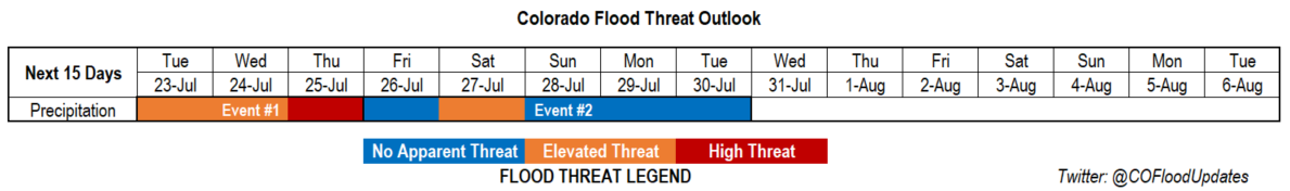
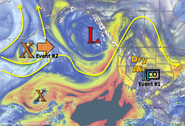
Active week ahead for this next FTO as the monsoon pattern sets up. Currently, the subtropical high is over the four corners region. Tomorrow the dry air marked in the water vapor imagery below will move through the state with NW/NNW flow aloft. This will decrease rain rates below flood threat criteria to the east, and the coverage of storms is expected to be patchier than the last couple of days. An Elevated Flood Threat (Event #1) has been issued as moisture will start to surge northward over the southwest corner of the state due to slight eastward movement of the high. This could be problematic for the 416 burn area as storms are expected to be nearly stationary over the San Juan Mountains. The PW surge over western Colorado continues on Wednesday and Thursday, with the low being pushed eastward by the incoming vorticity maximum. This shifts the ridge axis into a favorable position to advect a moist air mass over the state. Additionally, a weak cold front associated with this feature, drops through the eastern plains overnight on Wednesday. Post front upslope flow will cause a High Threat for Thursday.
By Friday, the ridge breaks down and the high moves into southern Arizona, which should decrease PW values statewide (Event #2). Scattered afternoon storms may be possible, but there is No Apparent Threat at this time. Saturday afternoon, a vorticity maximum passes over the state, which should aid in lift for more widespread storm coverage. There is an Elevated Threat for this day with the threat decreasing into Sunday. By early next week, NW flow will become more westerly and decreases the available moisture for rainfall. Temperatures will also be on the rise and with the jet brushing the northern border, critical fire weather may be possible sometime mid-next week. Please tune back into the FTO on Thursday of this week as details will likely change.
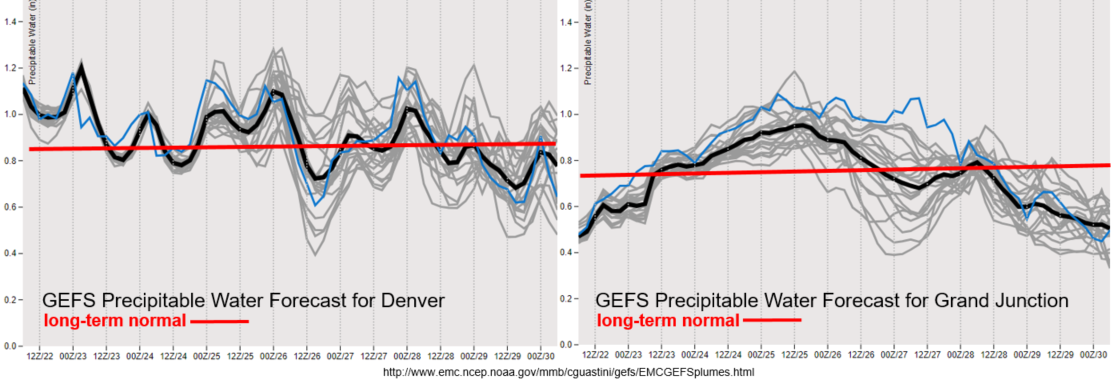
PW values look to decrease tomorrow after the dry air mass is pushed into eastern Colorado from the north. Different story to the west, where a PW surge begins. With PW well above climatology from Tuesday to Thursday, there is expected to be an uptick in afternoon and evening thunderstorm activity. The main threats will be gusty winds, severe hail and heavy, local rainfall. Slow storm motion under the ridge will also help increase totals. This will also put recent burn areas under the gun, especially if storms track over the scars more than one day in a row. To the west, a lot of disagreement between members after Wednesday about PW values. This likely has to do with the timing and intensity of the passing shortwave. Nonetheless, with upper level lift with the upslope flow pattern, there will be an Elevated Flood Threat on Saturday. PW looks to decrease statewide from Sunday into next week.
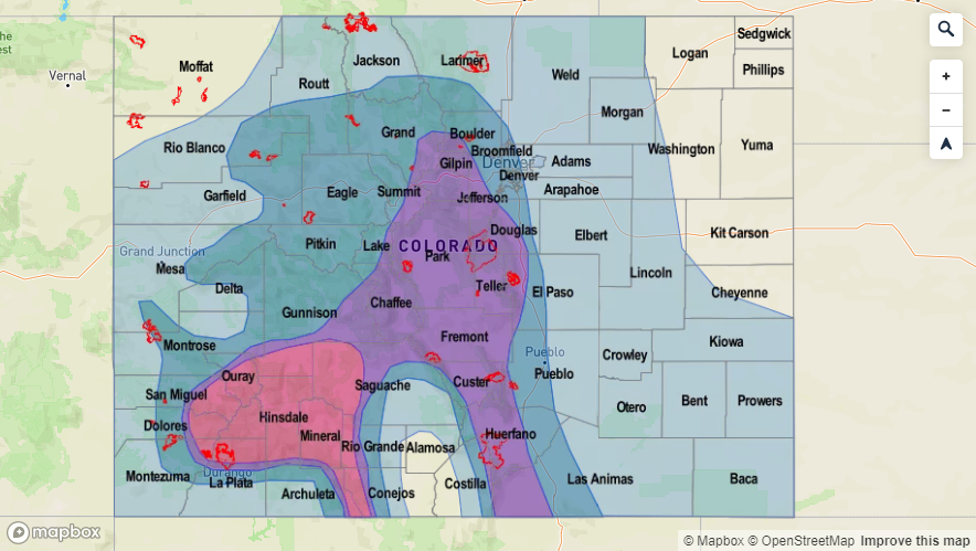
Event #1: Tuesday (7/23) – Thursday (7/25)
High/Elevated Threat as the monsoon kicks off with the threat starting over western Colorado and moving east thanks to an increase in moisture behind a passing cold front.
Looks like the monsoon will be in full swing for this event. Starting tomorrow, the slight movement of the ridge axis to the east will bring showers and thunderstorms back into the forecast for southwestern Colorado and decrease the heavy rainfall threat over eastern Colorado. Rain looks to be mostly confined to the San Juan Mountains and storm totals up to 1 inch will be possible. Although rain rates won’t quite reach flood threat criteria everywhere, if one of these nearly stationary storms moves or forms over the 416 burn area, flash flooding, mud flows and debris slides will be possible. Rainfall chances increase northward over western Colorado on Thursday with some thunderstorms likely over the valleys as well. Wednesday night, a cold front moves through eastern Colorado overnight, so there may be some weak thunderstorms and showers along this feature. Post upslope flow will create a High Flood threat for Thursday. More westerly flow aloft will allow these storms to move into the immediate adjacent plains and a couple of severe thunderstorms can’t be ruled out. Looking like the far eastern plains will be capped, but details like this are better forecast 24 hours before the forecast is valid. If there is rain over the eastern plains, expect the heaviest rainfall rates to be located along the elevated terrains of the Raton and Palmer Ridges. Please tune back into the FTB each morning for the latest heavy rainfall threat details.

Event #2: Friday (7/26) – Tuesday (7/30)
Elevated Threat/No Apparent Threat as on and off upper dynamics and moisture move through the area with more zonal flow.
More zonal flow during this period should keep the heavy rainfall threat at bay for the most part. For Friday, the subtropical high is over southern Arizona. This will keep the moisture needed for heavy rainfall to our south and east. A passing shortwave on Saturday will combine with some higher PW values over eastern Colorado. This would produce more widespread thunderstorm coverage, especially if it passes during peak heating. A boundary over the eastern Colorado may set up with a weak lee trough, which could cause a severe thunderstorm or two. Expect showers to increase as the feature passes overhead and over the eastern plains. Still low confidence in this forecast at this time, so please tune back in on Thursday for the next FTO. After Saturday, things look to dry out for a few days and some hot temperatures return to the forecast.