Issue Date: Monday, July 29th, 2019
Issue Time: 3:00PM MDT
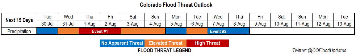
Valid Dates: 7/29 – 8/13
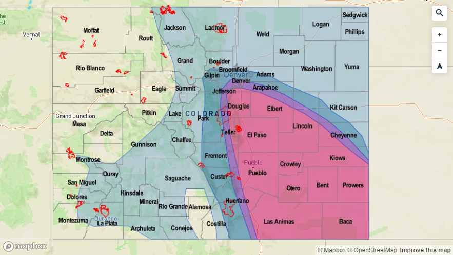
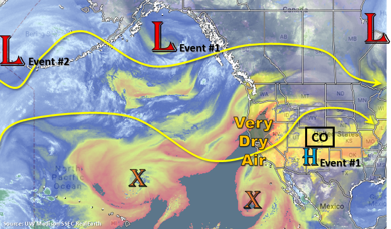
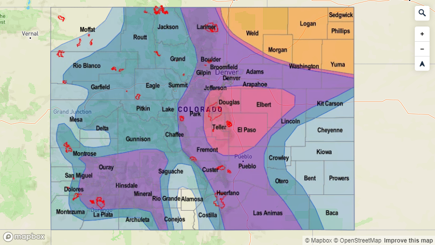
There is an Elevated/High flood threat for Event #1 of this FTO. As the high pressure slightly moves west into the TX panhandle Tuesday into Wednesday, the next monsoon PW surge occurs. The incoming low pressure system marked below is the instigator in the shift of the ridge axis to the east. Lee troughing will also help pull low level moisture northward over the eastern plains beginning on Tuesday afternoon. A cold front looks to drop through the state on Thursday, which often returns low level moisture, so a High flood threat is issued for post frontal upslope flow and overnight precipitation along the boundary over the Northeast Plains. The High threat continues on Friday, although the afternoon storm activity should be more of a mountain and adjacent plain flood threat due to capping over the plains. An Elevated flood threat continues through the weekend with the San Juan Mountains under the gun for western Colorado. Burn areas will be monitored daily throughout the event in the FTB.
For Event #2, the next trough digs south farther west than the last handful of systems. If this occurs, this will pull the subtropical high back to the west and put the state under more northwesterly flow aloft. Still lower confidence in the forecast this far out, but we will discuss it more nonetheless. This pattern would keep cooler temperatures in the forecast and prevent any long duration PW surges northward into the state. There is an Elevated flood threat on Tuesday in this scenario due to post frontal upslope flow. Faster steering winds should keep the threat over an limited area, but more of a westerly component to the steering flows would likely cause some rainfall over the eastern plains favoring the Southeast Plains, Palmer Ridge and Raton Ridge.
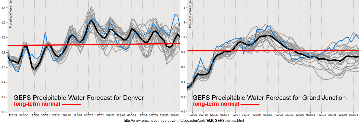
The next monsoon surge is quite visible in the GEFS PW plumes below (Event #1). By about Wednesday, PW values start to reach above climatology over eastern Colorado. This again is aided by a lee surface trough setting up on Tuesday. PW also creeps up over western Colorado by tomorrow night. So expect an increase in activity over the high country from Wednesday into Friday. The high then shifts into an unfavorable location for western Colorado rainfall and PW drops off drastically. Still some uncertainty in the forecast (west) after this weekend, but PW looks to remain at or just below climatology. So other than recent burn areas, the flood threat is anticipated to decrease.
Event #1: Tuesday (7/30) – Sunday (8/4)
High/Elevated Threat as the subtropical high shifts in to the Texas Panhandle and the next PW moisture surge begins.
Should have one more quiet day with limited afternoon storm activity before the next monsoon surge begins. By Wednesday, PW values start to edge above climatological values, which should increase storm coverage during the afternoon. Expecting western Colorado to be impacted first with the threat moving east on Thursday. A passing cold front overnight on Thursday may cause some nocturnal thunderstorms capable of producing some very heavy rain over the northern Urban Corridor and western portion of the Northeast Plains. Post frontal upslope flow will likely impact and cause heavy rainfall over the southern Front Range, Southeast Mountains and San Juan Mountains on Friday. This is probably the day that needs to be watched closest for flooding over recent burn areas. Rain continues Saturday over the high terrains with some thunderstorms also possible over the Colorado/Kansas border. Weak thunderstorms are forecast each of the afternoon with a couple of severe storms possible over the eastern plains. The severity of the thunderstorms will likely be determined by passing shortwaves. If timed with peak instability, a couple of severe thunderstorms may be possible with some large hail.

Event #2: Monday (8/5) – Thursday (8/8)
Elevated Threat/No Apparent Threat northwest flow aloft returns and shuts down rainfall activity over western Colorado.
Shift in the overall monsoon pattern if the GFS is right. The next low pressure system looks to dig south and west of California for this event. This would pull the subtropical high to our west and put eastern Colorado under northwest flow. It would really limit afternoon rain over western Colorado minus some weak storms and showers over the Central and San Juan Mountains. Cooler temperatures also look likely to start next week, which will be a nice break from the heat. A cold front may also be possible on Monday night, which could cause some heavier rainfall over the southeast quadrant of the state on Tuesday. This includes the Southeast Mountains and recent burn areas. However, higher PW values would quickly be pushed south and east under the flow aloft. This would only support scattered showers on Wednesday and Thursday capable of producing only light to moderate rain rates.