Issue Date: Thursday, July 25th, 2019
Issue Time: 2:50PM MDT
Valid Dates: 7/26 – 8/9
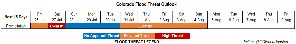
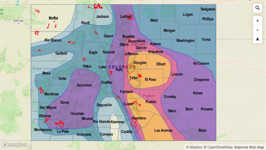
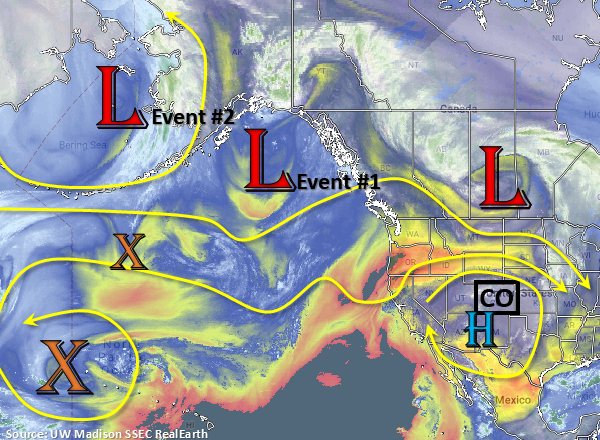
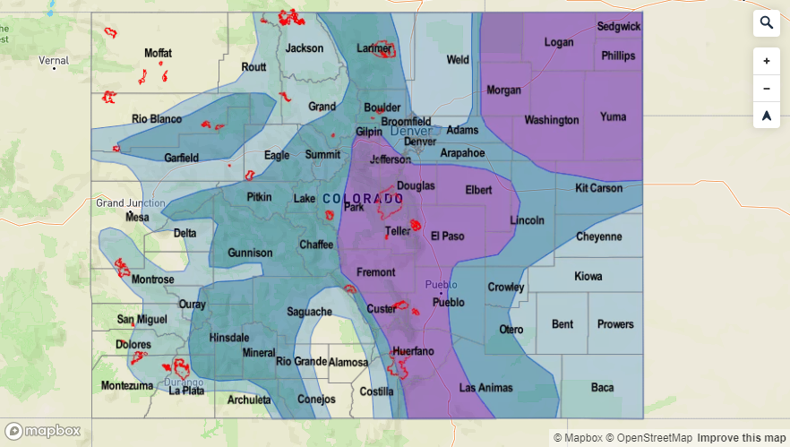
There is an Elevated/High flood threat to start this FTO, which is due to the location of the subtropical high tomorrow and then incoming upper level low on Saturday (Event #1). While most of eastern Colorado will begin to dry out tomorrow with flow aloft from the northwest, the Elevated flood threat continues for the southwest high terrains where flow aloft remains more westerly. Three days of rain over this area has likely saturated parts of the soil, so expecting an increase in runoff from storms tomorrow afternoon. On Saturday, the incoming trough (marked below) pushes towards the east and shifts the ridge with it. Meanwhile, the subtropical high moves into California/Arizona/southern Nevada, which will eject a fairly strong shortwave over the state for more widespread thunderstorm coverage and possibly an overnight MCS on the plains. There is a break in the heavy rainfall threat from Sunday into Tuesday, although there will likely be enough residual moisture for scattered storms to trigger over the mountains each afternoon. A passing cold front on Saturday night/early Sunday morning is expected to reduce highs 2-5°F over eastern Colorado on Sunday and Monday.
The next northward monsoon surge begins on Wednesday, and an Elevated flood threat will be issued for Event #2. The ridge begins to build back to the north with the center of the subtropical high centered somewhere near the Colorado/New Mexico/Texas Panhandle. There will likely be several shortwaves rotating around the high, which will cause the increased threat level as the next trough pushes the ridge axis east. Decreased steering winds under the high will cause storms over the higher terrains to produce more rainfall as well. In this classic monsoon setup, flooding may be possible each afternoon, although the area of the threat is anticipated to change day to day. The ridge looks to break down with the high moving west sometime to start that next week, resulting in a break for the heavy rainfall threat.
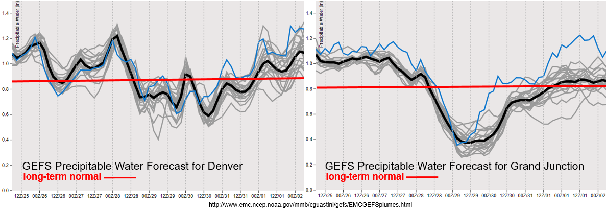
Reaching that point in the season where PW values are climatologically peaking, which means the above average values shown below are very impressive. Slight decrease in moisture over eastern Colorado tomorrow with flow aloft changing to the northwest and pushing in a little drier air from the north. Doesn’t take long for the values to increase again on Saturday night with south and southeast winds at the surface pulling in high moisture. To the west, above average moisture is forecast for western Colorado through Saturday. This will keep the flood threat around, especially with multiple days of rainfall in a row. PW drops statewide as the high builds over the southern Colorado border Sunday through Tuesday. Moisture then looks to return to more seasonal values mid-next week with the strengthening high pressure, associated building ridge and slight eastward placement of the ridge axis.
Event #1: Friday (7/26) – Sunday (7/28)
High/Elevated Threat as a shortwave combines with a PW moisture surge.
A strong lee trough looks to set up on Saturday, which will provide ample lift for afternoon storms in a moisture rich environment across the state. Best instability right now looks to be over the southern high terrains/Raton Ridge and the Northeast Plains/Palmer Ridge. Won’t be surprised if there are couple severe thunderstorms on Saturday across the plains with the main threats being large hail (up to 1.5 inches), heavy rainfall and gusty winds. Storms on Friday and Saturday will be problematic if they track over recent burn areas. Watching the 416/Spring Creek burn area on Friday and all recent burn areas listed on the help page on Saturday. A passing cold front overnight on Saturday and decrease in moisture should keep afternoon storm activity more quiet on Sunday. Scattered showers will be likely over the higher terrains in the afternoon with residual moisture over the area.

Event #2: Monday (7/29) – Sunday (8/4)
Elevated Threat/No Apparent Threat break in rainfall to start the week before the next monsoon moisture surge occurs.
The ridge begins to build back to the north on Monday and Tuesday, which should suppress a lot of afternoon storm activity. The highest PW values are expected to be south of the state, though there looks to be enough moisture for a couple light afternoon showers or weak thunderstorms over the high terrains over eastern Colorado. By Wednesday, the building ridge will pull more moisture up from the south and slight eastward movement of the ridge axis, will pull the high PW values into the state. This will increase the heavy rainfall threat into the weekend. Details will likely change, but for now just wanted to mention moderate confidence for increased storminess. Afternoon shortwaves, similar to this current event, will likely rotate around the high, which may have an impact on rainfall duration and spatial coverage if they are timed with peak instability.