FTO 08-15-2019: Elevated Flood Threat Issued for Eastern Colorado & Critical Fire Weather Forecast over Western Colorado

Issue Date: Thursday, August 15th, 2019
Issue Time: 12:25PM MDT
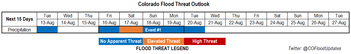
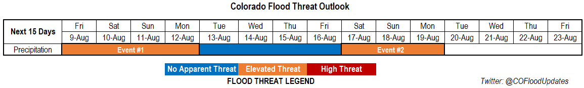
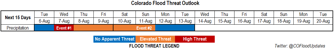
Valid Dates: 8/16 – 8/30

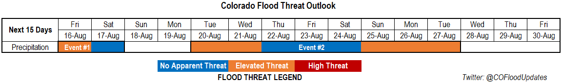
Event #1 of this FTO begins tomorrow and the Elevated flood threat lasts only a day as dry air and subsidence moves back into the area on Saturday. The flood threat tomorrow would be over the eastern plains with severe thunderstorms possible along a boundary that forms due to lee troughing. Dynamics in the area would allow these storms to produce large hail (greater than 2 inches), damaging winds and heavy rainfall. Storms will be moving moderately fast, so not thinking this will be more than a Low flood threat at this time. However, if the shortwave from Wyoming is moving fast enough to arrive during the afternoon or early evening, this threat may need to be upgraded. Please tune into the FTB tomorrow.

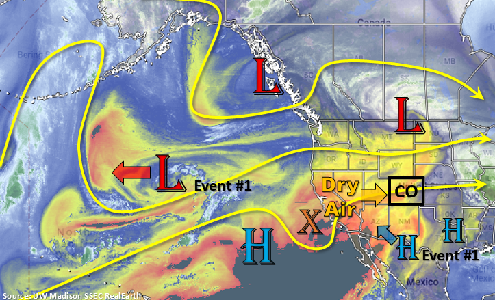
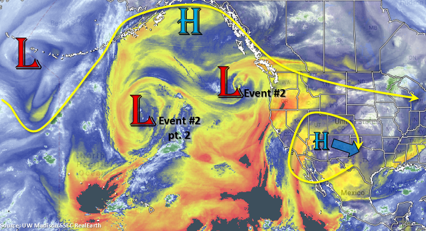
Break in heavy rainfall for a couple of days and very hot temperatures before a weak PW surge occurs over the eastern half of Colorado. The passing shortwaves to the north set up a nice ridge pattern that puts this area in a favorable position for subtropical moisture advection and post frontal upslope flow. Shortwaves moving around the ridge will likely enhance coverage of storms, but only if they are timed correctly. Higher PW values are kept east and south of the state at the end of next week before the next statewide monsoon surge begins. Thus, the Elevated threat at the end of Event #2. Still lower confidence this far out in the actual flood threat, but an active pattern is back in place starting Tuesday.

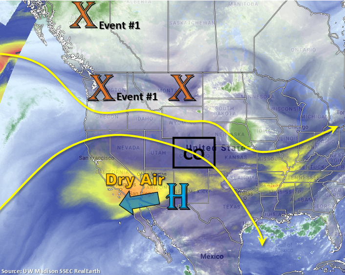
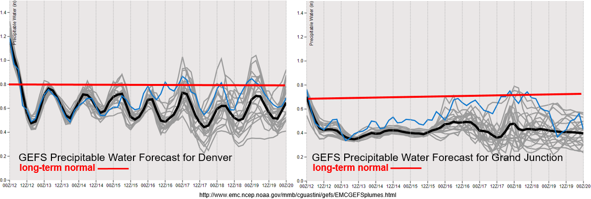
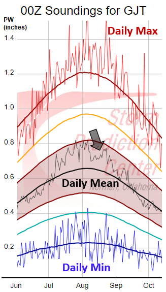
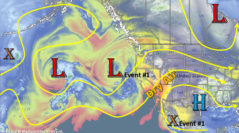
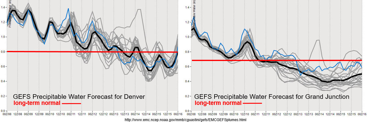
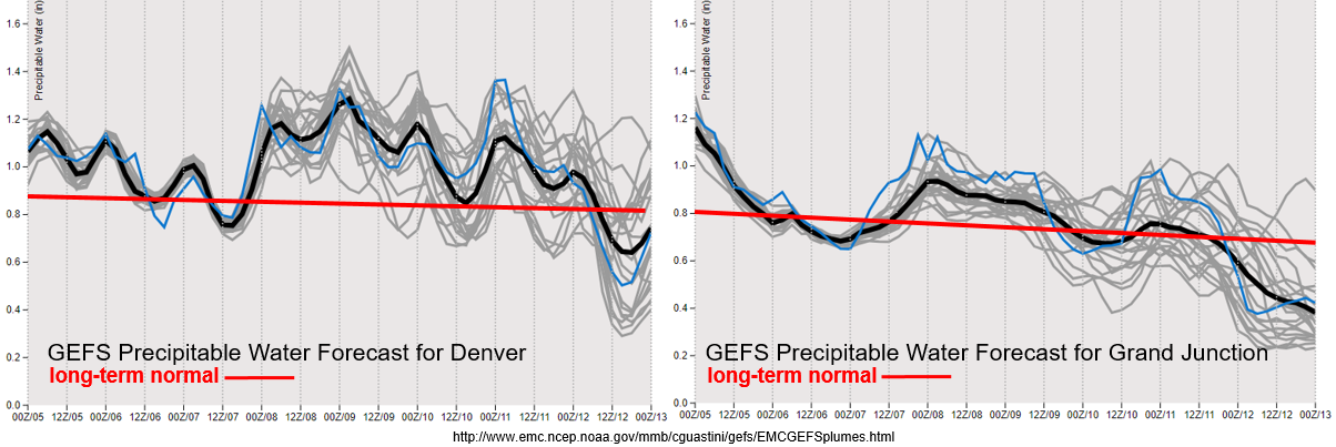
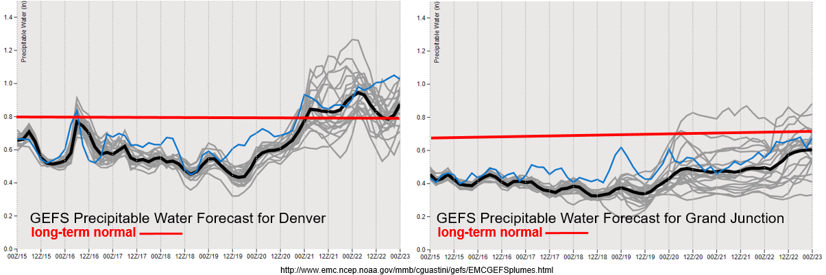
Not much change in the GEFS moisture plumes from the last FTO. PW values looks to increase back to the west over eastern Colorado temporarily tomorrow before dropping off again. The return of subtropical moisture over eastern Colorado can be seen Tuesday and Wednesday in the graphic on the left (last couple of days). Over western Colorado, enhanced jet activity over the northern border and very low moisture will likely cause critical fire weather Friday and Saturday. A Red Flag Warning is in place for Friday, which will likely be issued again for Saturday. Please see NWS Grand Junction for more up to date information. Slight high moisture for the next passing trough may keep fire issues at bay, but still quite a bit of spread in the model members (gray lines).

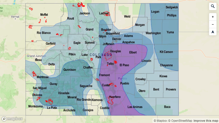
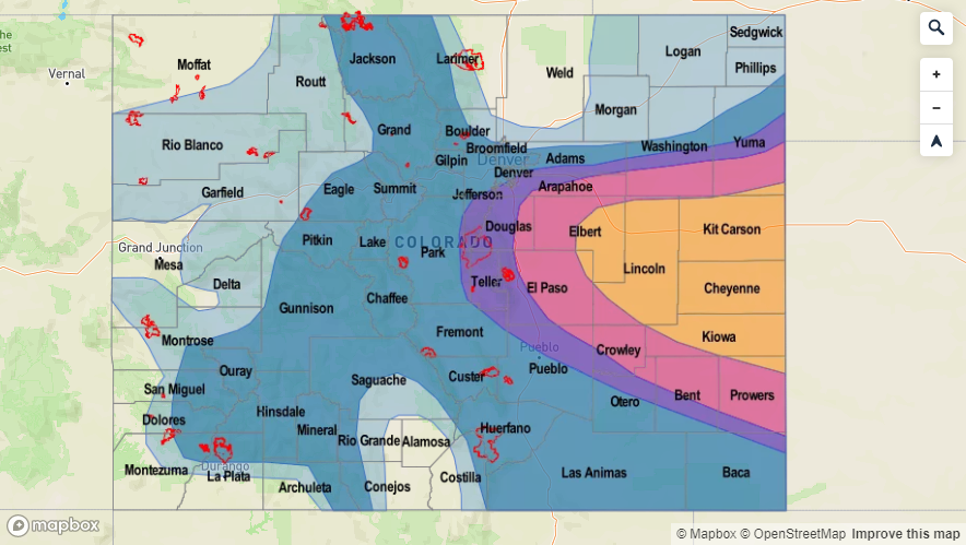
Event #1: Friday (8/16) – Saturday (8/17)

Elevated Threat/No Apparent Threat for a lee trough and associated severe thunderstorms in a moisture rich environment.  

While the storms with this setup have been moving fairly quickly the last couple of days, the amount of rain they have produced has been quite impressive. That is why there is an Elevated flood threat issued for tomorrow. As storms tomorrow move from the Northeastern Plains into the Palmer Ridge/northern Southeast Plains, steering winds should slow down a little, so more accumulation is likely in the higher dew point region. We’ll still have to see where the dry line sets up tomorrow and how tight the gradient is, but there is a very good chance for a couple severe thunderstorms capable of heavy rainfall. The main threats from the storms will be damaging winds and, once again, large hail (greater than 2 inches). Not a great sign for the crops, so hopefully coverage is isolated (looks to be this way now). Saturday, a couple scattered storms may be possible with residual moisture over the mountains and adjacent plains. The far eastern plains look to remain capped, so that should keep the severe threat minimal.

Legend


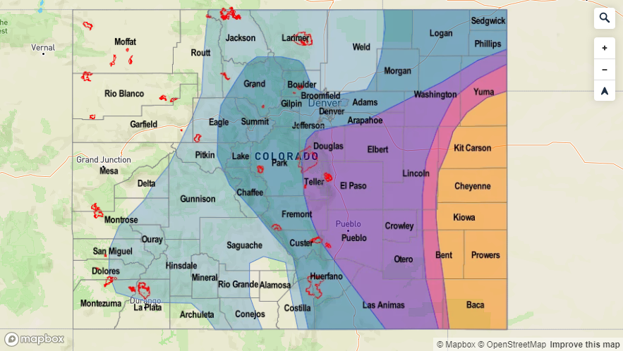
Event #2: Tuesday (8/20) – Tuesday (8/27)

Elevated Threat/No Apparent Threat as an active weather pattern sets up with on and off moisture east and west of the Continental Divide.

Elevated threat is first for this event over eastern Colorado, and then the next Elevated threat is for the full state. There looks to be heavy mountain precipitation on Tuesday and Wednesday following the passage of a cold front (return of low level moisture). Not thinking it will be a large threat area for flooding, but burn areas will need to be watched especially closely over the Southeast Mountains. The flood threat decreases for a bit before the next statewide monsoon surge sometime near next weekend. Not yet sure of the strength of the surge, but worth mentioning as this could bring some much needed rainfall to western Colorado. The majority of the area (minus the eastern San Juan Mountains) is 0.75 to 1.5 inches below normal. The Southwest Slope and northwest corner of the state has been put back into the D0 drought category, which means it is Abnormally Dry. Hoping for a good monsoon surge as this could easily be the last one of the season and help get some of the areas out of drought troubles (as minimal as they are).

Legend

FTO 08-12-2019: Dry Air and Northwest Flow is Forecast to Bring a Pause in Heavy Rainfall Events

Issue Date: Monday, August 12th, 2019
Issue Time: 1:45PM MDT
Valid Dates: 8/13 – 8/27

Event #1 from the last FTO is the low pressure system that is now over Montana. This trough and the dry air associated with, has caused moisture to drop off across the western US (yellow and oranges in the water vapor imagery below). This dry air will continue to work its way into Colorado from west to east with westerly flow aloft. The zonal atmospheric pattern the next couple of days is expected to keep quieter weather over the state and limit the amount of precipitation in the forecast. A weak cold front will continue to push through the eastern plains today, which will keep temperatures a bit cooler, too. Not expecting much rainfall with this frontal passage due to capping at 500mb (temperature inversion preventing air parcels from lifting), but a few storms over the Southeast Plains may be possible near the NM border. Flow shifts to the northwest Tuesday night into Wednesday as the subtropical high rebuilds over the four corners region. This is pattern will also cause the low to retrograde back to the east (marked below).

By Friday, a weak troughing pattern looks to set up over the west coast. As this moves to the northwest sometime between Friday into Sunday (timing still unknown), the 500mb high will push east as well (NM/TX/OK panhandle area). This would likely return subtropical moisture to the state, and mid-level energy from the passing trough, may also act to create more widespread coverage of showers and thunderstorms one of those days. Thus, the brief Elevated Threat for Event #1. Note that this looks like a weaker heavy rain event compared to the last two (coverage/strength) and confidence is still low. This is due to the strength of the system (not well-pronounced and trending downwards), and the details of ingredients needed for heavy rain could easily change. The other reason for the Elevated flood threat is for burn areas.

After a very strong monsoon surge, heavy rainfall, and severe weather, PW values looks to drop off drastically east and west of the Continental Divide for the remainder of this week. Friday into Sunday (end of the graphs) shows why there is such low confidence in the next system producing heavy rainfall. At best, it looks like PW values recover to climatological values, but there is still a lot of spread in the models. If values are able to move closer to climatology, storms may be capable of causing flooding issues over recent burn areas. Interestingly, Grand Junction usually sees a second moisture surge, after a climatological lull, about this time of year. This can be seen in the image below with the black arrow. This surge isn’t looking likely this season with the current set up, and PW values looking closer to the 10% moving average. Right now, not thinking any daily minimum PW records are going to be broken, but the dry air is a concern for fire weather. Elevated fire weather may be possible over the northwest corner of the state late this week (Thursday-Saturday) when the jet pushes into northern Colorado and orients itself west to east. We will be watching this closely in the FTB and updates to the FTO on Thursday will include more information.


Event #1: Friday (8/16) – Monday (8/19)

Elevated Threat/No Apparent Threat as the next weak trough develops over the west coast. When it pushes to the northeast this weekend, slight eastward movement of the ridge may allow for a modest moisture surge.  

Should be a quiet week with slightly cooler temperatures anticipated under westerly and northwesterly flow. While some afternoon storms are possible (minus Wednesday) over the far eastern plains and mountains each afternoon, not thinking there is any flood threat due to the lack of moisture and swift movement of the storms. Mostly anticipating storms to produce gusty winds as well light rainfall. Lee troughing sets up on Friday and lasts through the weekend. This may allow for some stronger storms to develop during this event. However, with the jet overhead, storms should be moving quickly Friday and Saturday and best dynamics looks to line up east of Colorado. This again looks to be more of an eastern Colorado event, and the best chances for rain will over western Colorado will occur on Sunday and Monday. Going to watch for a possible, small scale PW surge over the southwest corner at the beginning of next, but at this time, it looks like the larger values will stay to our south.

Legend

FTO 08-08-2019: Approaching Trough Maintains the Current Moisture Surge and Keeps Heavy Rainfall Chances Elevated through this Weekend

Issue Date: Thursday, August 8th, 2019
Issue Time: 2:45PM MDT
Valid Dates: 8/9 – 8/23

There are two events identified in this FTO. Event #1 from the last FTO is currently ongoing through tomorrow, but for simplicity sake, I tied it into the heavy rainfall event forecast this weekend since the dynamics are similar enough. Friday into this weekend, the low marked below will start to traverse east. This will push out some mid-level energy in front of it, which will also mix with shortwaves moving around the subtropical high. This will help create more widespread storm activity, especially if the shortwaves pass overhead during peak heating. At the same time, the subtropical high will be in a favorable position to maintain the PW surge, although values are forecast to drop off a bit from today. This PW surge will mostly favor locations east of the Continental Divide, but some higher PW values are expected to push northward over the southwest corner of the state Saturday and Sunday before the upper flow turns more westerly (dries it out). This could be problematic for the 416 burn area as rain rates will likely increase. Some cooler temperatures are forecast for this weekend, and much cooler temperatures are forecast for early next week after a cold front pushes south Monday into Monday night.

There is a lull in afternoon rain during the work week as the subtropical high becomes rather weak and broad over our area. This will allow more westerly winds, which will pull in dry air from the west (similar to the mechanism seen below). The next low looks to move through sometime near the weekend of August 17th. Not as much confidence in this forecast, but the narrow ridge would be pushed east allowing for a weaker monsoon surge northward. Models pointing to the monsoon season wrapping up after this event, which if it occurs, would lineup with climatology.

Incredible PW surge currently going on, which is always possible during the monsoon season. PW values over western CO are close to daily max PW records and, obviously, well above climatology. This surge is expected to last through this weekend before the model members start showing a decline in PW values. Expect the coverage of storms to follow this trend with isolated afternoon showers and thunderstorms likely only over the mountains from Tuesday forward. To the west, PW is currently declining due to the dry air (marked in the image above) rotating around the high and into western Colorado. Slight moisture surge on Saturday, which will be something to watch for the 416 burn area. Very low moisture by the end of next week and the approaching trough will cause us to watch for fire weather conditions. However, an increase in southwest winds is also anticipated, so the more likely scenario is that these winds will intensify the moisture; thus, lessening the chances for fire weather.


Event #1: Friday (8/9) – Monday (8/12)

Elevated Threat as the next trough approaches, it slides the ridge axis to the east and allows for an ongoing moisture surge.  

Heavy rainfall is anticipated for this event, although there is not a High threat issued. For one, the moisture sure isn’t as strong as this last surge; and two, faster steering winds should limit the areal coverage of the threat. Monday will be watched closely, because if the front drops south during the afternoon, it may cause some widespread heavy rainfall and severe weather over the plains. The main threats would be heavy rainfall, hail and strong winds. Friday and Saturday will have the most coverage of storms during this period due to upper level energy also moving into the state in the high moisture environment. Models have also been consistently showing cooler temperatures over northeastern Colorado for Saturday as well. Heavy rainfall over the eastern plains will be most likely on Monday, though there looks to be some gradual, heavy accumulating rainfall along the CO/WY border Sunday. Burn areas over the Southeast Mountains will be watched closely on Friday with eyes turning to the 416 burn area this weekend.

Legend


Event #2: Saturday (8/17) – Monday (8/19)

Elevated Threat as the vertically amplified ridge shifts east with the next passing low, which returns high PW values to eastern Colorado.

Not a lot of confidence in the forecast as this is so far out. Thus, there is no precipitation map drawn below. Since it’s still monsoon season, thinking this will look similar to a typical monsoonal moisture event. However, it is getting pretty late into the monsoon season and the pattern isn’t quite textbook, so thinking it will be on the weaker end of the Elevated Threat at this time. Not horrible disagreement between models members on the Spaghetti plot (relative to a 216+ hour forecast), so fairly confident it will happen. However, there will likely be a lot of changes in the timing and details of the event, so please tune back into the FTOs next week for the latest details.


FTO 08-05-2019: Heavy Rainfall Threat Returns with the Frontal Passage on Wednesday

Issue Date: Monday, August 5th, 2019
Issue Time: 4:00PM MDT
Valid Dates: 8/6 – 8/20

There is lull in heavy rainfall tomorrow before a High/Elevate flood threat is issued through this weekend. Taking a look at the water vapor imagery below, quite a bit of dry air circulating up and around the Pacific and west coast. It is usually a bit more concentrated in nature with stronger drying near the equator. With the subtropical high over Arizona, some of that dry air (yellow/orange) has worked its way into western Colorado. This has decreased the chances for rainfall from Sunday to today, and it will continue to do so through tomorrow. Event #1 kicks into full gear on Wednesday as the ridge begins to get squashed and a cold front is pushed through eastern Colorado. This is due to multiple shortwaves rotating around the high/low (labelled Event #2), which will also help enhance lift for widespread coverage of afternoon and evening storms. Lee troughing on Wednesday and Thursday will also help return low level moisture to eastern Colorado on its north side. However, low level moisture on its east side will likely stay over Kansas. More westerly steering flows will allow storms to move into the adjacent and eastern plains, so some heavy rainfall and marginal severe weather may be possible on both days. Thus, there is a High/Elevated flood threat issued through Friday.

After Friday, the high begins to rebuild over Texas. This will pull more Gulf of Mexico moisture into eastern Colorado, creating a PW surge. At this same time, the low pressure system marked below begins to move inland. This is expected to increase shortwave activity and southwest flow this weekend. The associated jet may also create some fire weather danger concerns over northwest Colorado, but there is lower confidence in that forecast as this time. More zonal flow behind the trough will mix out moisture, so there is No Apparent Threat and a break in heavy rainfall forecast to start next week.

First thing that catches my eye about the images below is that average PW is starting to decrease (red line), which means climatologically, the monsoon starts to taper off. The second thing is the variability between model members after Wednesday (gray lines), which just means there is more uncertainty in my forecast for this weekend. With that said, there is quiet the moisture return after the passage of the cold front on Wednesday over eastern Colorado. Paired with an increase in dynamic (shortwaves, boundary, etc.), heavy rainfall will be likely and may last overnight on Wednesday over the eastern plains. The moisture sticks around on Thursday, but storms will likely be confined to the mountains due to capping over the eastern plains. With favorable dynamics in place over the weekend and Gulf of Mexico moisture likely over eastern Colorado (if the high reforms over Texas), thinking PW will be on the higher end of climatology. Thus, the Elevated flood threat.

To the west, there is a slight increase in moisture on Wednesday and Thursday as well, although not quite as much as the last couple of systems. The subtropical high will be in an unfavorable location to produce widespread heavy rainfall. Nevertheless, expecting these days to have the greatest coverage of storms over the higher terrains. Quite the downtick in moisture through this weekend into next week. If the moisture drops off before the approaching low (and associated jet stream), there might be an increase in fire danger over the northwest corner at the end of this weekend into early next week.

Event #1: Tuesday (8/6) – Friday (8/9)

High/Elevated Threat as post frontal upslope flow and numerous shortwaves combine for favorable heavy rainfall environment.  

Discussed this event quite a bit above, but I will add a few more details down here. On top of high moisture and favorable dynamics, storm motion is expected be very slow over the eastern high country and adjacent plains on Wednesday. Thus, some very heavy accumulations should be expected under storms that form, especially over the eastern plains (isolated totals > 2.5 inches). Surface based CAPE and decent directional and speed shear (shifting of winds with height) may cause storms along the Palmer Divide and east to produce some large hail and strong winds as well. The hail threat will decrease as instability lessens a couple of hours after sundown. Recent burn areas, especially the Spring Creek burn scar, will be monitored closely in the FTB throughout this event as rain rates could be high enough to cause flash flooding and mud flow issues. To the west, the best chance for flooding rain rates over the Lake Christine and 416 burn areas will be on Wednesday. More isolated coverage on storms on Thursday should decrease the overall flood threat to the west including the burn areas. Please be sure to tune into the FTO on Thursday for the latest and follow the FTB for the daily flood threat update.

Legend


Event #2: Saturday (8/10) – Tuesday (8/13)

Elevated Threat as the ridge begins to rebuild over Texas, which returns high PW values to eastern Colorado.

With the more southern and eastern position of the subtropical high, this event will favor heavier rainfall over eastern Colorado. The ridge is weaker than usual over the state for this event, which mean weaker easterlies for upslope flow. The main flood threat for this event will be storms that make it further east under the westerly and southwesterly steering flows. If the peak in diurnal heating coincides with a passing shortwave over the adjacent plains, coverage of the heavy rainfall is forecast be much greater with some severe thunderstorms likely. The right entrance of the jet region will also be watched closely as this could cause some storms to linger overnight, which would increase accumulations. As mentioned before, lower confidence this far out and with varying model members. Please tune back into the FTO on Thursday as details will become clearer.

Legend