Issue Date: Monday, August 12th, 2019
Issue Time: 1:45PM MDT
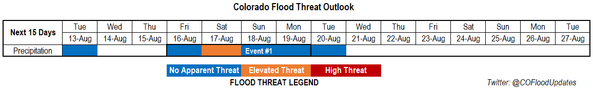
Valid Dates: 8/13 – 8/27
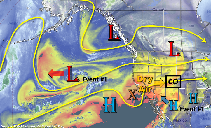
Event #1 from the last FTO is the low pressure system that is now over Montana. This trough and the dry air associated with, has caused moisture to drop off across the western US (yellow and oranges in the water vapor imagery below). This dry air will continue to work its way into Colorado from west to east with westerly flow aloft. The zonal atmospheric pattern the next couple of days is expected to keep quieter weather over the state and limit the amount of precipitation in the forecast. A weak cold front will continue to push through the eastern plains today, which will keep temperatures a bit cooler, too. Not expecting much rainfall with this frontal passage due to capping at 500mb (temperature inversion preventing air parcels from lifting), but a few storms over the Southeast Plains may be possible near the NM border. Flow shifts to the northwest Tuesday night into Wednesday as the subtropical high rebuilds over the four corners region. This is pattern will also cause the low to retrograde back to the east (marked below).
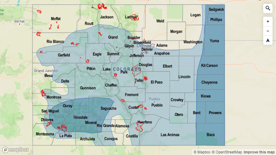
By Friday, a weak troughing pattern looks to set up over the west coast. As this moves to the northwest sometime between Friday into Sunday (timing still unknown), the 500mb high will push east as well (NM/TX/OK panhandle area). This would likely return subtropical moisture to the state, and mid-level energy from the passing trough, may also act to create more widespread coverage of showers and thunderstorms one of those days. Thus, the brief Elevated Threat for Event #1. Note that this looks like a weaker heavy rain event compared to the last two (coverage/strength) and confidence is still low. This is due to the strength of the system (not well-pronounced and trending downwards), and the details of ingredients needed for heavy rain could easily change. The other reason for the Elevated flood threat is for burn areas.
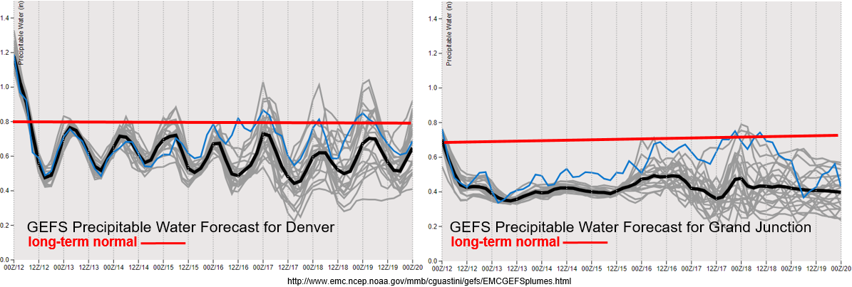
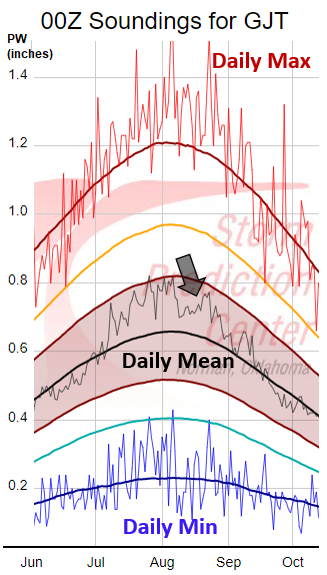
After a very strong monsoon surge, heavy rainfall, and severe weather, PW values looks to drop off drastically east and west of the Continental Divide for the remainder of this week. Friday into Sunday (end of the graphs) shows why there is such low confidence in the next system producing heavy rainfall. At best, it looks like PW values recover to climatological values, but there is still a lot of spread in the models. If values are able to move closer to climatology, storms may be capable of causing flooding issues over recent burn areas. Interestingly, Grand Junction usually sees a second moisture surge, after a climatological lull, about this time of year. This can be seen in the image below with the black arrow. This surge isn’t looking likely this season with the current set up, and PW values looking closer to the 10% moving average. Right now, not thinking any daily minimum PW records are going to be broken, but the dry air is a concern for fire weather. Elevated fire weather may be possible over the northwest corner of the state late this week (Thursday-Saturday) when the jet pushes into northern Colorado and orients itself west to east. We will be watching this closely in the FTB and updates to the FTO on Thursday will include more information.
Event #1: Friday (8/16) – Monday (8/19)
Elevated Threat/No Apparent Threat as the next weak trough develops over the west coast. When it pushes to the northeast this weekend, slight eastward movement of the ridge may allow for a modest moisture surge.
Should be a quiet week with slightly cooler temperatures anticipated under westerly and northwesterly flow. While some afternoon storms are possible (minus Wednesday) over the far eastern plains and mountains each afternoon, not thinking there is any flood threat due to the lack of moisture and swift movement of the storms. Mostly anticipating storms to produce gusty winds as well light rainfall. Lee troughing sets up on Friday and lasts through the weekend. This may allow for some stronger storms to develop during this event. However, with the jet overhead, storms should be moving quickly Friday and Saturday and best dynamics looks to line up east of Colorado. This again looks to be more of an eastern Colorado event, and the best chances for rain will over western Colorado will occur on Sunday and Monday. Going to watch for a possible, small scale PW surge over the southwest corner at the beginning of next, but at this time, it looks like the larger values will stay to our south.