Issue Date: Thursday, August 8th, 2019
Issue Time: 2:45PM MDT
Valid Dates: 8/9 – 8/23
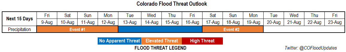
There are two events identified in this FTO. Event #1 from the last FTO is currently ongoing through tomorrow, but for simplicity sake, I tied it into the heavy rainfall event forecast this weekend since the dynamics are similar enough. Friday into this weekend, the low marked below will start to traverse east. This will push out some mid-level energy in front of it, which will also mix with shortwaves moving around the subtropical high. This will help create more widespread storm activity, especially if the shortwaves pass overhead during peak heating. At the same time, the subtropical high will be in a favorable position to maintain the PW surge, although values are forecast to drop off a bit from today. This PW surge will mostly favor locations east of the Continental Divide, but some higher PW values are expected to push northward over the southwest corner of the state Saturday and Sunday before the upper flow turns more westerly (dries it out). This could be problematic for the 416 burn area as rain rates will likely increase. Some cooler temperatures are forecast for this weekend, and much cooler temperatures are forecast for early next week after a cold front pushes south Monday into Monday night.
There is a lull in afternoon rain during the work week as the subtropical high becomes rather weak and broad over our area. This will allow more westerly winds, which will pull in dry air from the west (similar to the mechanism seen below). The next low looks to move through sometime near the weekend of August 17th. Not as much confidence in this forecast, but the narrow ridge would be pushed east allowing for a weaker monsoon surge northward. Models pointing to the monsoon season wrapping up after this event, which if it occurs, would lineup with climatology.
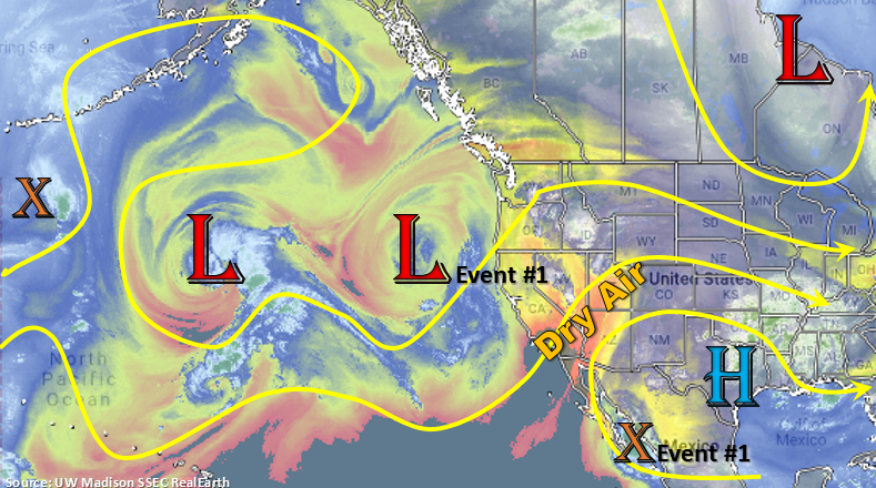
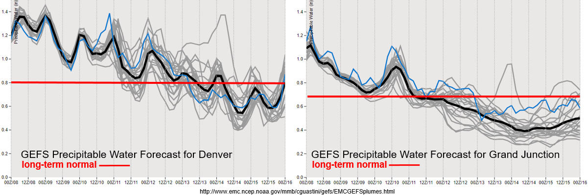
Incredible PW surge currently going on, which is always possible during the monsoon season. PW values over western CO are close to daily max PW records and, obviously, well above climatology. This surge is expected to last through this weekend before the model members start showing a decline in PW values. Expect the coverage of storms to follow this trend with isolated afternoon showers and thunderstorms likely only over the mountains from Tuesday forward. To the west, PW is currently declining due to the dry air (marked in the image above) rotating around the high and into western Colorado. Slight moisture surge on Saturday, which will be something to watch for the 416 burn area. Very low moisture by the end of next week and the approaching trough will cause us to watch for fire weather conditions. However, an increase in southwest winds is also anticipated, so the more likely scenario is that these winds will intensify the moisture; thus, lessening the chances for fire weather.
Event #1: Friday (8/9) – Monday (8/12)
Elevated Threat as the next trough approaches, it slides the ridge axis to the east and allows for an ongoing moisture surge.
Heavy rainfall is anticipated for this event, although there is not a High threat issued. For one, the moisture sure isn’t as strong as this last surge; and two, faster steering winds should limit the areal coverage of the threat. Monday will be watched closely, because if the front drops south during the afternoon, it may cause some widespread heavy rainfall and severe weather over the plains. The main threats would be heavy rainfall, hail and strong winds. Friday and Saturday will have the most coverage of storms during this period due to upper level energy also moving into the state in the high moisture environment. Models have also been consistently showing cooler temperatures over northeastern Colorado for Saturday as well. Heavy rainfall over the eastern plains will be most likely on Monday, though there looks to be some gradual, heavy accumulating rainfall along the CO/WY border Sunday. Burn areas over the Southeast Mountains will be watched closely on Friday with eyes turning to the 416 burn area this weekend.

Event #2: Saturday (8/17) – Monday (8/19)
Elevated Threat as the vertically amplified ridge shifts east with the next passing low, which returns high PW values to eastern Colorado.
Not a lot of confidence in the forecast as this is so far out. Thus, there is no precipitation map drawn below. Since it’s still monsoon season, thinking this will look similar to a typical monsoonal moisture event. However, it is getting pretty late into the monsoon season and the pattern isn’t quite textbook, so thinking it will be on the weaker end of the Elevated Threat at this time. Not horrible disagreement between models members on the Spaghetti plot (relative to a 216+ hour forecast), so fairly confident it will happen. However, there will likely be a lot of changes in the timing and details of the event, so please tune back into the FTOs next week for the latest details.