FTO 09-12-2019: Warm and Dry Weekend with Rainfall Returning Next Week

Issue Date: Thursday, September 12th, 2019
Issue Time: 12:40PM MDT
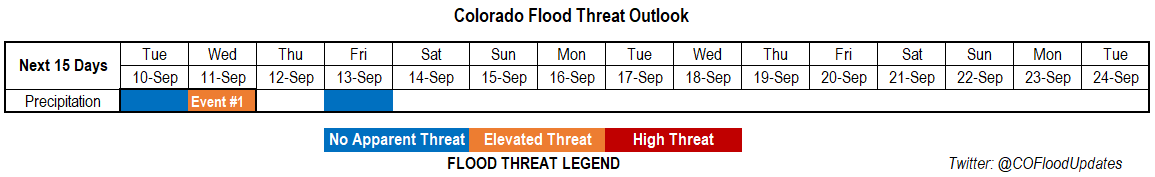
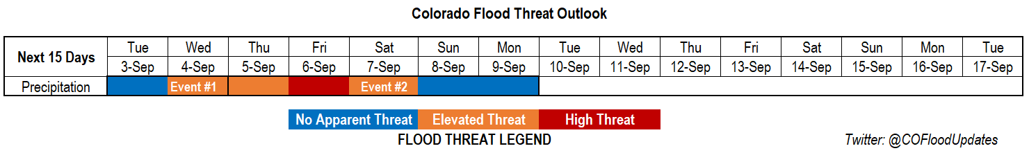
Valid Dates: 9/13 – 9/27

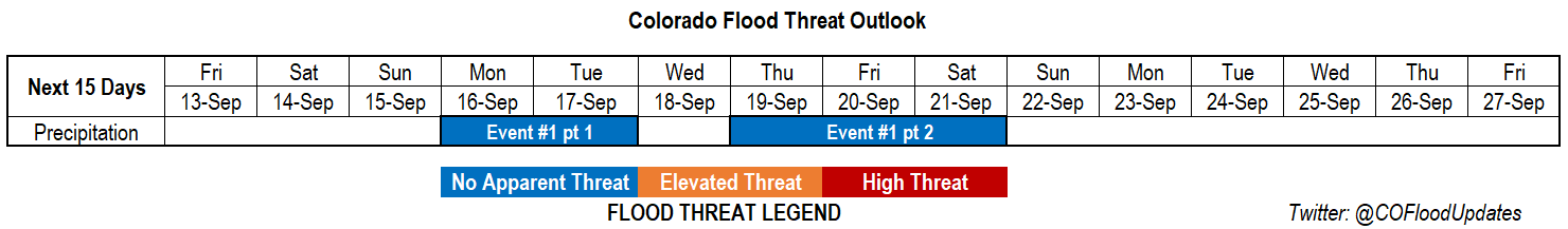
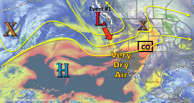
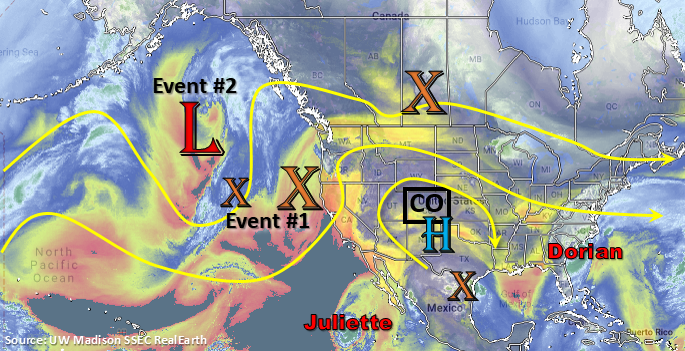
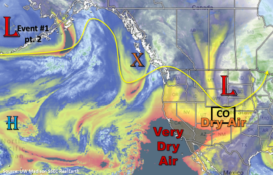
Should be almost completely rain free through this weekend, although there may be some isolated storms possible over the mountains during the afternoon hours. Zonal flow will produce westerly winds aloft, so a couple storms my wander into the adjacent plains. However, dry air will also be in place, so not thinking these storms will produce much, if any, rainfall. Temperatures also start to climb as the ridge builds over the state. A trough starts to develop and deepen to our west on Sunday, which will change flow aloft to southwesterly. This will possibly pull in disturbances on Monday/Tuesday, and with an increase in moisture, some weak afternoon thunderstorms will be possible over the mountains and western Colorado (Event #1 pt 1).

Wednesday is looking to be quiet as the trough pulls northward and subsidence is over the state. There will likely be cooler temperatures as well. The low re-digs back over the Great Basin for Thursday, which may push some mid-level lift into the state ahead of the trough. As the system pulls to the northeast sometime on Thursday and Friday, this will return the chances for more widespread showers and thunderstorms. Storm motion will again be swift (similar to this last system), and with limited moisture, there is No Apparent Flood Threat at this time. This may be upgraded for one of the days as confidence increases for the timing of the event. Linger moisture on Saturday my produce some showers over the mountains, and depending on where the convergence line ends up, the Southeast Plains may get a couple thunderstorms as well.

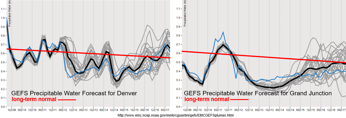
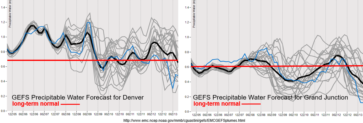
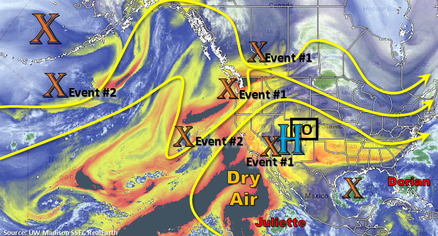
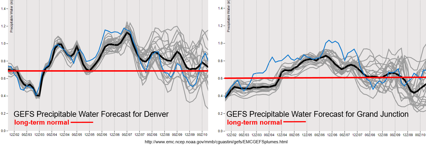
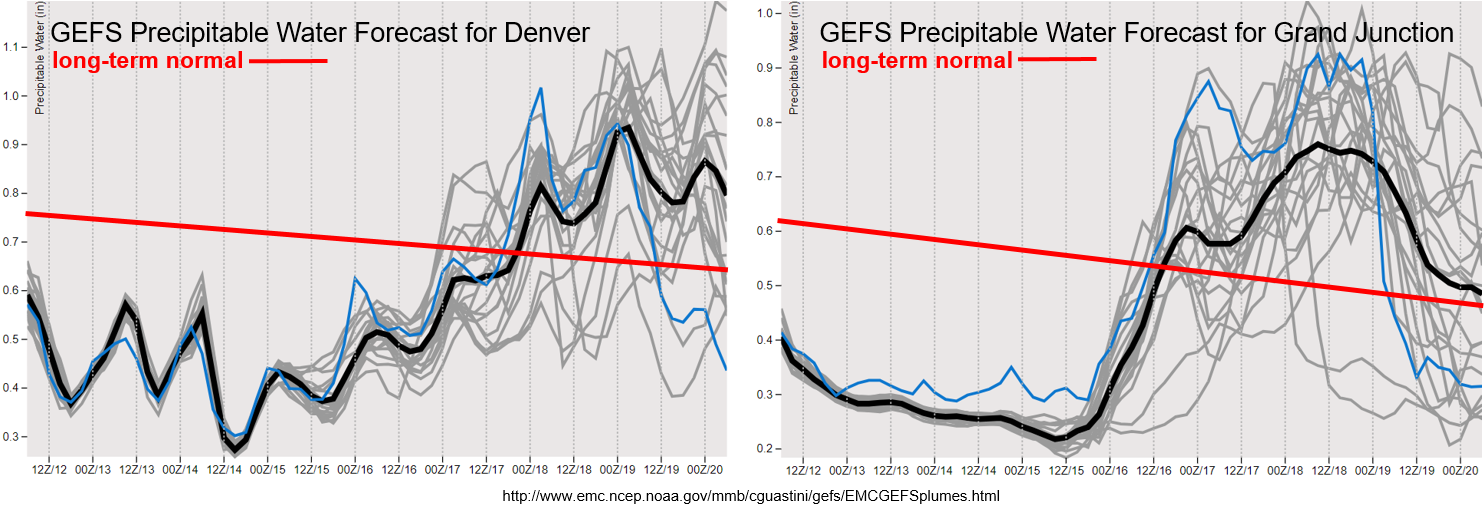
PW is quite low through the weekend for both Grand Junction (west) and Denver (east). The jet still looks to be mostly north of the state and without any mixing of strong winds down to the surface near the northern border, not thinking there will be any fire danger tomorrow and into this weekend. PW starts to creep up with the first part of Event #1 early next week. Thinking this will be more of a western Colorado/mountain event. However, a couple weak storms over the far Southeast Plains can’t be ruled out. Model members aren’t in full agreement with the moisture return, but right now thinking storms (to the west) will look similar to the system that just passed through. Tune back in on Monday as model agreement will likely better align.

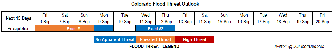
Event #1: Monday (9/16) – Saturday (9/21)

No Apparent Threat as a shortwave and large trough moves across the state.

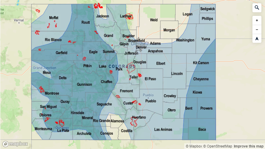
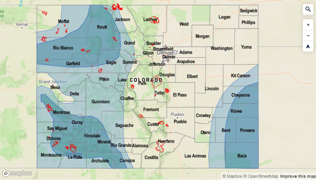
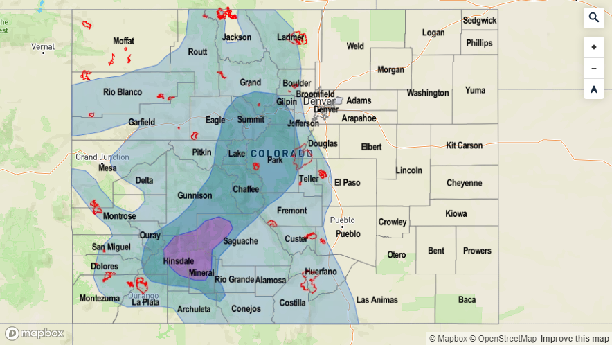
There will be a nice break in rainfall until the next system moves through and increases PW temporarily. Again, looking like a mountain and western Colorado event. Flooding is not anticipated at this time due to lower levels of moisture associated with the system. The main threats will be small hail and gusty winds from thunderstorms if the shortwaves line up with peak heating. At this time, thinking storm motion will be fast enough and rain rates low enough (fewer pockets of decent instability) that flooding will be avoided. Recent burn areas over western Colorado will be watched closely in the FTB on Monday into Tuesday.

The stronger system likely moves through sometime between Thursday and Friday next week. This will bring better chances of statewide rainfall. Not a ton of confidence in this forecast yet as it’s a bit far out. Right now, not looking like a huge moisture surge, and with fast storm motion once again, flooding should be avoided. Excepting the first day to be more of a threat over western Colorado, and the rainfall transitioning to the east on the second day. Rain rates look to have the potential to cause flooding issues if storms track over a recent burn area. So, this will be monitored in the FTB and updated in Monday’s FTO as confidence is again on the lower end for this forecast for now.

Legend

FTO 09-09-2019: Quick 1-day Flood Threat Before the State Begins to Dry Out

Issue Date: Monday, September 9th, 2019
Issue Time: 2:10PM MDT
Valid Dates: 9/10 – 9/24

Event #1 should be short and quick with a trough moving swiftly from west to east on Tuesday and Wednesday. Expect the low (marked below) to dig southeast a bit before traveling east. Showers and weak thunderstorms are forecast on Tuesday afternoon over western Colorado as a shortwave travels through the state ahead of the trough. Storms will move to the northeast fairly quickly and with PW only around 0.7 inches, there is No Apparent Threat. A second set of storms may be possible over the Southeast Plains along a dryline. Wednesday, the main axis of the trough moves through the state. Thus, showers and thunderstorms are expected to be more widespread and stronger in nature. Timing will also be on the earlier end, so storms should start with lighter rainfall and intensify with a little daytime heating (building instability). Again, rainfall will favor the western high terrains with the highest accumulations anticipated along the Colorado/Utah border. Additional weak thunderstorms will be possible over the eastern plains along and north of a weak cold front. Depending on timing of the frontal passage, weak thunderstorms or no thunderstorms could be forecast in the FTB. Not thinking there will be a flood threat either way at this time.

Weather will be rain free on Thursday with subsidence and drier air filling in behind the trough. A weak shortwave may help produce some light showers on Friday over Colorado’s eastern border. However, after the trough passage, the upper level flow will be from the west. This will pull in a very dry air mass; thus, rainfall elsewhere is not anticipated on Friday and may help kill the convection chances over the eastern border. This very dry air mass hangs on through Monday with the westerly flow aloft continuing. So expecting no rainfall this weekend with temperatures ~5°F warmer than climatology.

Note that the PW scales below have been reduced now that we are moving into fall. The long-term averages are also continuing to show a negative trend. For western Colorado, moisture returns with the trough and shortwaves moving through the flow. With PW around 0.7 inches and multiple rounds of rain over an area, isolated totals up to 0.75 inches to 1 inch may be possible on Wednesday. The best chance for this type of accumulation would be over the high terrains along the western CO border. PW looks to drastically drop off after the event, and with the jet brushing the northern border, fire weather may be possible this weekend. Be sure to check in with your local NWS office and the daily FTB for up to date information over the weekend.

PW drops off to more climatological values over eastern Colorado this afternoon. There is a nice diurnal cycle of moisture shown with a fairly consistent message between model members. Higher moisture may hang on over the eastern border depending on where the dryline/cold front sets up, so a few higher totals may be possible if storms can break the cap. Flooding is not anticipated at this time for eastern Colorado.

Event #1: Tuesday (9/10) – Wednesday (9/11)

Elevated Threat as a trough moves across the state and produces showers and thunderstorms over western Colorado.

The next trough begins to traverse eastward on Tuesday into Wednesday. This should produce storms over western Colorado on both days. Storms are expected to be stronger on Wednesday and will favor the high terrains over the western border. With some dry air still expected in the low levels, brief wind gusts will be possible with the stronger storms along with small hail. Not sure how instability will look (has to do with timing of the trough axis) during the afternoon on Wednesday. However, if some decent instability is able to build, could see some higher rain rates. This will be especially important to track for the Lake Christine burn area. Additional storms may be possible each afternoon over the eastern plains. Not thinking these eastern Colorado storms will have flooding issues at this time with the highest dew points to the east.

Legend

FTO 09-05-2019: Elevated Flood Threat Going into the Weekend

Issue Date: Thursday, September 5th, 2019
Issue Time: 2:45PM MDT
Valid Dates: 9/6 – 9/20

Finally, the high pressure that has been producing the above average temperatures will begin to break down as a series of troughs move through the western US. This more seasonal pattern will bring cooler temperatures and rainfall back into the forecast, which is probably welcomed by everyone at this point. The heavy rainfall threat returns to Colorado tomorrow after a cold front moves through the eastern plains this evening and helps return low level moisture (Event #1). There will likely be some high clouds behind the front and models indicated some light rainfall over the Northeast Plains tomorrow morning. Moisture remains high over eastern Colorado and elevated over the mountains for the duration of this event, and multiple troughs moving through the area at the same time will cause an Elevated threat to be issued through Sunday. Not quite as much moisture over western Colorado on Friday and Saturday, but there should be enough moisture for isolated afternoon showers and weak thunderstorms over the high terrains during the afternoon. The best chance for statewide rainfall accumulation will be on Sunday as a strong trough moves eastward just to our north.

The ridge begins to slightly build back over the state at the beginning of next week, which should pull in a dry air mass with westerly and southwesterly flow aloft. Thus, precipitation chances decrease until the next trough moves through sometime on Wednesday or Thursday (Event #2). Not very confident on the timing of this, but it will be a quick moving system. The GFS oscillates back and forth with the amount of moisture associated with this system, which is likely related to the changing strength and location with each run. However, due to the quick pace of the trough, there is Apparent Threat for Event #2 at this time.

PW over Denver is very elevated (for this time of year) during Event #1 with a slight decrease in moisture between the two passing shortwaves. To the west, not much change, which is to be expected with the high’s location. Expect more of the same for western Colorado for Event #1, but a slight increase in storm coverage on Sunday. Model members are trending downward in PW after the weekend both east and west, thus the decrease in flood threat. As for Event #2, quite a bit of spread in the models, which means it is a low confidence forecast. Please tune back into the FTO on Monday as details will likely become clearer.

Event #1: Friday (9/6) – Monday (9/9)

Elevated Threat as moisture returns to the mountains and eastern Colorado along with multiple shortwaves forecast to move through the westerly flow.

A cold front moves through the eastern plains tonight, which should return quite a bit of low level moisture. Guidance indicating some light showers may be possible over the Northeast Plains tomorrow morning, but at the least, there will be cooler temperatures and cloud cover behind the front. The heavy rainfall threat returns with more numerous and stronger storms anticipated over the higher elevations tomorrow afternoon. Storm totals over the mountains will likely be between 0.5 and 1 inch for the stronger storms or where multiple storms track over the same area. As storms move into the adjacent plains, unsure what the environment will look like. If the plains are capped or have limited instability (morning cloud cover doesn’t burn off early enough), not thinking a heavy rainfall threat will exist. We’ll also have to look at where the shortwaves are in tomorrow’s water vapor imagery to see if they could help break the cap over the plains.

On Saturday, there is a chance for some severe thunderstorms over the Northeast Plains (and heavy rainfall) with more coverage of storms over the mountains. Threats for the severe thunderstorms include severe hail, strong winds and localized flooding. Over the mountains, recent burn areas will also need to be watched closely. Sunday is now looking like the best chance for statewide rain and heavy rainfall. Once again, recent burn areas will need to be monitored closely.

Legend

Event #2: Wednesday (9/11) – Thursday (9/12)

No Apparent Threat as a quick moving, possibly strong trough moves across the state on one of these days. Behind the trough, large scale subsidence should cause a break in rainfall chances.

Not a ton of confidence in this forecast yet as it is a bit far out to judge the timing, strength, and location of the next passing trough. Temperatures will likely more seasonable during this period with a slight increase on Monday and Tuesday with the building high pressure. If this a strong trough, as the latest model runs have been indicating, high temperatures may drop into the low 70°Fs behind the front. Otherwise, looking at highs behind the system to reach the 80°Fs and 70°Fs over the mountains and higher elevation valleys, respectively.

Legend

FTO 09-02-2019: Cool Temperatures and Rainfall are on Their Way

Issue Date: Monday, September 2nd, 2019
Issue Time: 4:10PM MDT
Valid Dates: 9/3 – 9/17

A more active pattern is getting ready to take hold, which should return cooler temperatures and rainfall to the forecast. It has been quite the hot last couple of days with lots of daily and September high temperature records broken statewide. Relief is on the way with a cold front passing through tomorrow morning (Event #1). This should also return some showers and thunderstorms to the high terrains with a little storm spill over into the immediate adjacent plains. The eastern plains look to remain capped at this time, so there is No Apparent Threat. On Wednesday, storms pick up in intensity over the mountains, especially the San Juan and Central Mountains, as PW and mid-level energy combine for an Elevated Threat. The 416 burn area will be monitored closely, and you can find the latest details about the flood threat for this area in the FTB on Wednesday.

PW remains elevated across eastern Colorado on Thursday and Friday due to passing shortwaves placing the ridge axis in a favorable position for moisture return. Mid-level energy passing through will help create more widespread storm activity with several cold fronts keeping high temperatures more seasonable. A High/Elevated Threat has been issued for the first part of Event #2 due to slow storm motion with the favorable rainfall setup. The flood threat decreases Sunday into Monday with more zonal flow over the state and a weak ridge starting to build to our west.

The PW plumes below are from the midnight GEFS run as supercomputer power has been shifted over to Hurricane Dorian. Quite the PW recovery for Denver with the passing cold front tomorrow. There is a lull in PW after Event #1, but values quickly return to an inch or above for Event #2. There is a steady increase over western Colorado as well with values above climatology from Wednesday to Saturday. This should provide some relief to hot temperatures over the region in the form of afternoon cloud cover and rainfall. Quite a bit of spread in the model members after Sunday night, so have held off in creating Event #3 due to low confidence. Hurricane Juliette could make her way over the state next week as she’s absorbed into the westerly flow and a passing shortwave. This could help return some moisture to the state for better afternoon storm coverage, but this is not looking like a large heavy rainfall event at this time.

You’re definitely correct if you thought August felt hot and dry over western Colorado and the mountains. A handful of stations had their warmest temperatures on record with the majority of western Colorado recording much above average normal temperatures (top 10% from 1895-2010). It was also hot for El Paso/Teller Counties where temperatures were 5°F warmer than normal! As far as precipitation the Northeast Plains, Palmer Ridge and eastern Southeast Plains did alright with above normal to much above normal precipitation. The monsoon didn’t quite show up over western Colorado again this year. Delta, eastern Montrose and eastern Mesa Counties had their record breaking driest August to date. Montezuma and western La Plata Counties went back into drought stage (D1), which isn’t surprising considering this area was in the bottom 10% of all rainfall years (1895-2010) with some areas seeing the driest August on record. Hoping the changing pattern this week can bring a little relief to western Colorado without causing too many flooding or lightning issues. Streamflow, surprising, still looks fairly normal despite the extremely dry August and drying trend seen in July for the western half of Colorado (not shown, but see the SPM from Friday, August 31st).

Event #1: Tuesday (9/3) – Wednesday (9/4)

No Apparent to Elevated Threat as post frontal upslope flow returns moisture for afternoon storms over the mountains.

Relief from the heat is almost here with the cold front moving through the state on Tuesday morning. Highs will still likely reach the 90°Fs over the far Southeast Plains, but temperatures should drop into the 80°Fs over the Northeast Plains with 80°F for the Urban Corridor. Gusty winds (35 to 40mph) will likely accompany the front, so you will know when it’s passing overhead. Overcast skies and warm air aloft should help keep the plains capped, so heavy rainfall is not anticipated at this time. Best chance for rainfall will be over the Front Range and eastern San Juan Mountains. On Wednesday, the flood threat increases with a small PW surge, mid-level energy and slow steering winds combining during the afternoon and evening hours. Best chance for heavy rainfall will be over the southern Front Range/Palmer Ridge intersect and San Juan Mountains. The 416 burn area will also need to be monitored closely. Threats include mud flows, debris slides and local stream flash flooding for storms that produce a half inch or greater over the burn area.

Legend

Event #2: Thursday (9/5) – Monday (9/9)

High to No Apparent Threat with the High threat on Friday evening focused over the eastern plains.

Expecting several cold fronts to pass through the area during this time period, which combined with moisture will cause the flood threat to return. Thursday, it looks like western Colorado will be the target of the heavy rainfall threat with widespread showers and thunderstorms returning to the forecast. By Friday, the threat returns to all of the high terrains, and also spreads into the adjacent eastern plains. Severe weather may be possible over the eastern plains (right now models are focused on the Palmer Ridge), but at this time, the threat doesn’t look too widespread. The slower storm motion will be the main cause of the High threat. Again, High threat in the FTO means there will likely be more than a Low flood threat issued in the FTB. Heavy rainfall will likely continue on Saturday with the southern high terrains mostly under the gun with post frontal upslope flow. The recent burn areas over the Southeast Mountains will need to be watched closely. Of course, there will be more confidence and details in Thursday’s FTO, so be sure to tune in! Sunday into Monday, the next dry air plume looks to move overhead, which should decrease storms activity. Isolated to scattered thunderstorms over the high terrains will still be possible during the afternoon and evening with the residual moisture.

Legend