Issue Date: Monday, September 9th, 2019
Issue Time: 2:10PM MDT
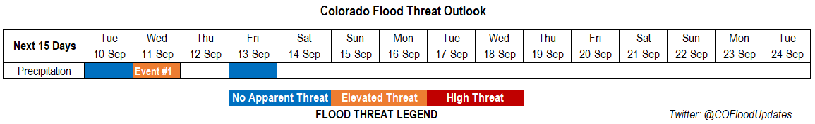
Valid Dates: 9/10 – 9/24
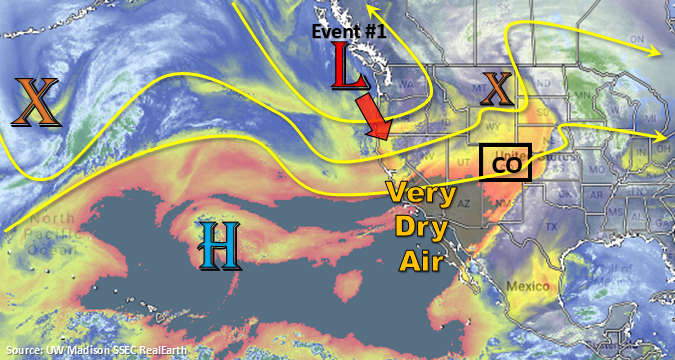
Event #1 should be short and quick with a trough moving swiftly from west to east on Tuesday and Wednesday. Expect the low (marked below) to dig southeast a bit before traveling east. Showers and weak thunderstorms are forecast on Tuesday afternoon over western Colorado as a shortwave travels through the state ahead of the trough. Storms will move to the northeast fairly quickly and with PW only around 0.7 inches, there is No Apparent Threat. A second set of storms may be possible over the Southeast Plains along a dryline. Wednesday, the main axis of the trough moves through the state. Thus, showers and thunderstorms are expected to be more widespread and stronger in nature. Timing will also be on the earlier end, so storms should start with lighter rainfall and intensify with a little daytime heating (building instability). Again, rainfall will favor the western high terrains with the highest accumulations anticipated along the Colorado/Utah border. Additional weak thunderstorms will be possible over the eastern plains along and north of a weak cold front. Depending on timing of the frontal passage, weak thunderstorms or no thunderstorms could be forecast in the FTB. Not thinking there will be a flood threat either way at this time.
Weather will be rain free on Thursday with subsidence and drier air filling in behind the trough. A weak shortwave may help produce some light showers on Friday over Colorado’s eastern border. However, after the trough passage, the upper level flow will be from the west. This will pull in a very dry air mass; thus, rainfall elsewhere is not anticipated on Friday and may help kill the convection chances over the eastern border. This very dry air mass hangs on through Monday with the westerly flow aloft continuing. So expecting no rainfall this weekend with temperatures ~5°F warmer than climatology.
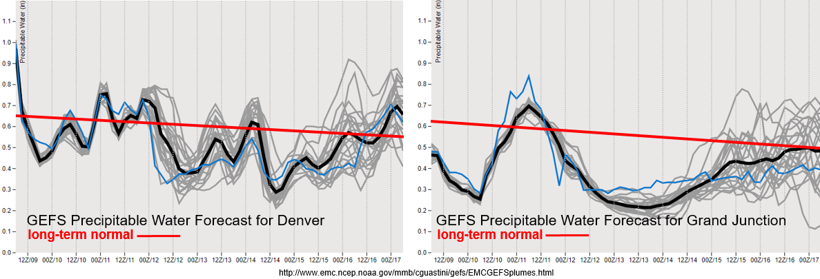
Note that the PW scales below have been reduced now that we are moving into fall. The long-term averages are also continuing to show a negative trend. For western Colorado, moisture returns with the trough and shortwaves moving through the flow. With PW around 0.7 inches and multiple rounds of rain over an area, isolated totals up to 0.75 inches to 1 inch may be possible on Wednesday. The best chance for this type of accumulation would be over the high terrains along the western CO border. PW looks to drastically drop off after the event, and with the jet brushing the northern border, fire weather may be possible this weekend. Be sure to check in with your local NWS office and the daily FTB for up to date information over the weekend.
PW drops off to more climatological values over eastern Colorado this afternoon. There is a nice diurnal cycle of moisture shown with a fairly consistent message between model members. Higher moisture may hang on over the eastern border depending on where the dryline/cold front sets up, so a few higher totals may be possible if storms can break the cap. Flooding is not anticipated at this time for eastern Colorado.
Event #1: Tuesday (9/10) – Wednesday (9/11)
Elevated Threat as a trough moves across the state and produces showers and thunderstorms over western Colorado.
The next trough begins to traverse eastward on Tuesday into Wednesday. This should produce storms over western Colorado on both days. Storms are expected to be stronger on Wednesday and will favor the high terrains over the western border. With some dry air still expected in the low levels, brief wind gusts will be possible with the stronger storms along with small hail. Not sure how instability will look (has to do with timing of the trough axis) during the afternoon on Wednesday. However, if some decent instability is able to build, could see some higher rain rates. This will be especially important to track for the Lake Christine burn area. Additional storms may be possible each afternoon over the eastern plains. Not thinking these eastern Colorado storms will have flooding issues at this time with the highest dew points to the east.