Issue Date: Monday, September 2nd, 2019
Issue Time: 4:10PM MDT
Valid Dates: 9/3 – 9/17
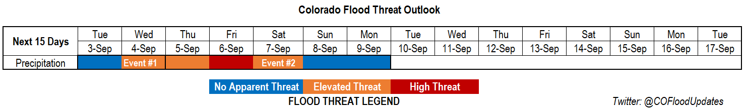
A more active pattern is getting ready to take hold, which should return cooler temperatures and rainfall to the forecast. It has been quite the hot last couple of days with lots of daily and September high temperature records broken statewide. Relief is on the way with a cold front passing through tomorrow morning (Event #1). This should also return some showers and thunderstorms to the high terrains with a little storm spill over into the immediate adjacent plains. The eastern plains look to remain capped at this time, so there is No Apparent Threat. On Wednesday, storms pick up in intensity over the mountains, especially the San Juan and Central Mountains, as PW and mid-level energy combine for an Elevated Threat. The 416 burn area will be monitored closely, and you can find the latest details about the flood threat for this area in the FTB on Wednesday.
PW remains elevated across eastern Colorado on Thursday and Friday due to passing shortwaves placing the ridge axis in a favorable position for moisture return. Mid-level energy passing through will help create more widespread storm activity with several cold fronts keeping high temperatures more seasonable. A High/Elevated Threat has been issued for the first part of Event #2 due to slow storm motion with the favorable rainfall setup. The flood threat decreases Sunday into Monday with more zonal flow over the state and a weak ridge starting to build to our west.
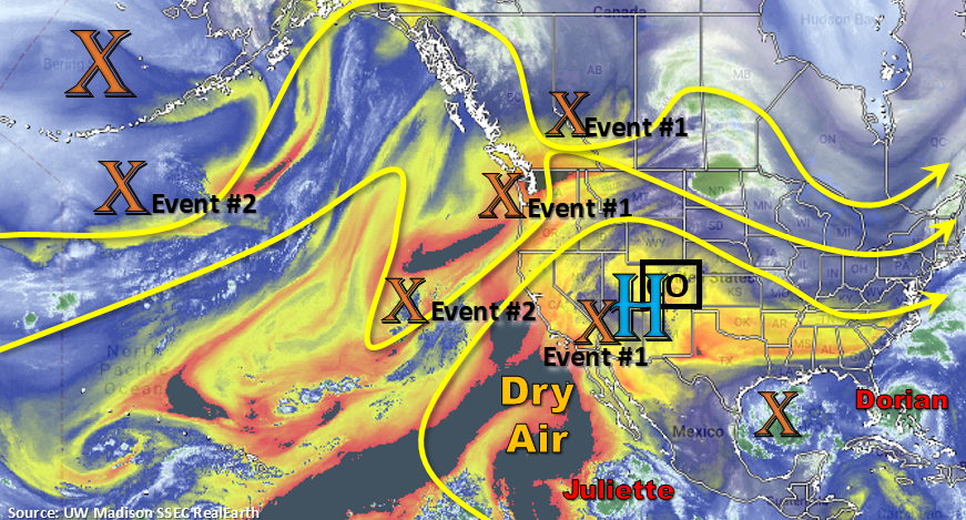
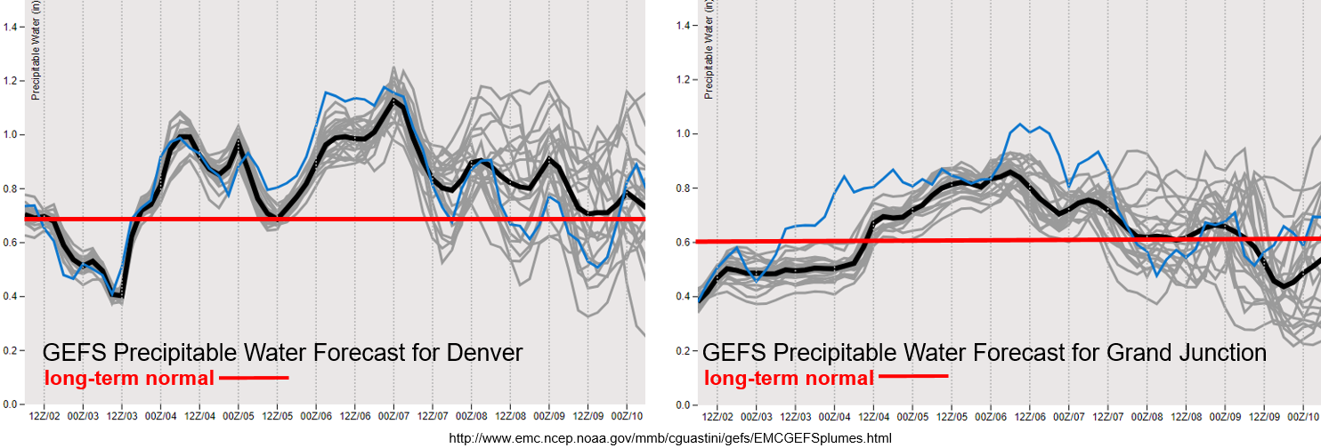
The PW plumes below are from the midnight GEFS run as supercomputer power has been shifted over to Hurricane Dorian. Quite the PW recovery for Denver with the passing cold front tomorrow. There is a lull in PW after Event #1, but values quickly return to an inch or above for Event #2. There is a steady increase over western Colorado as well with values above climatology from Wednesday to Saturday. This should provide some relief to hot temperatures over the region in the form of afternoon cloud cover and rainfall. Quite a bit of spread in the model members after Sunday night, so have held off in creating Event #3 due to low confidence. Hurricane Juliette could make her way over the state next week as she’s absorbed into the westerly flow and a passing shortwave. This could help return some moisture to the state for better afternoon storm coverage, but this is not looking like a large heavy rainfall event at this time.
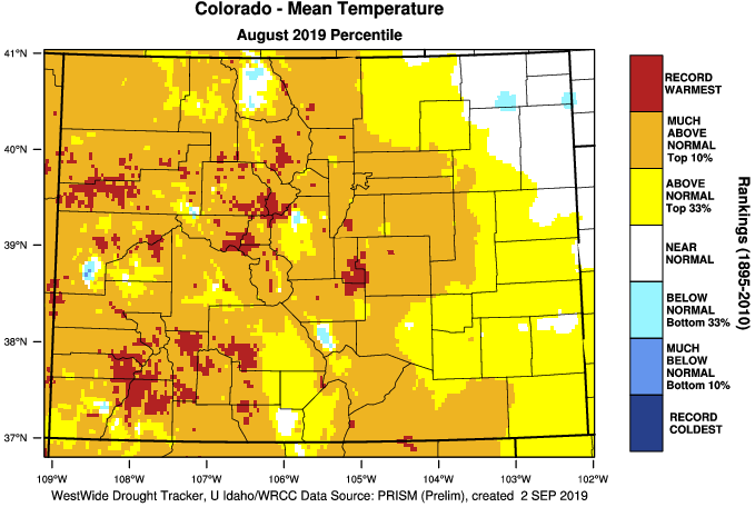
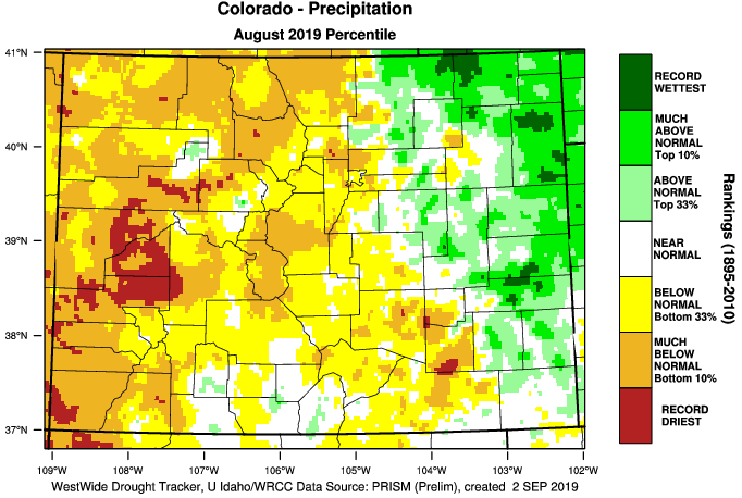
You’re definitely correct if you thought August felt hot and dry over western Colorado and the mountains. A handful of stations had their warmest temperatures on record with the majority of western Colorado recording much above average normal temperatures (top 10% from 1895-2010). It was also hot for El Paso/Teller Counties where temperatures were 5°F warmer than normal! As far as precipitation the Northeast Plains, Palmer Ridge and eastern Southeast Plains did alright with above normal to much above normal precipitation. The monsoon didn’t quite show up over western Colorado again this year. Delta, eastern Montrose and eastern Mesa Counties had their record breaking driest August to date. Montezuma and western La Plata Counties went back into drought stage (D1), which isn’t surprising considering this area was in the bottom 10% of all rainfall years (1895-2010) with some areas seeing the driest August on record. Hoping the changing pattern this week can bring a little relief to western Colorado without causing too many flooding or lightning issues. Streamflow, surprising, still looks fairly normal despite the extremely dry August and drying trend seen in July for the western half of Colorado (not shown, but see the SPM from Friday, August 31st).
Event #1: Tuesday (9/3) – Wednesday (9/4)
No Apparent to Elevated Threat as post frontal upslope flow returns moisture for afternoon storms over the mountains.
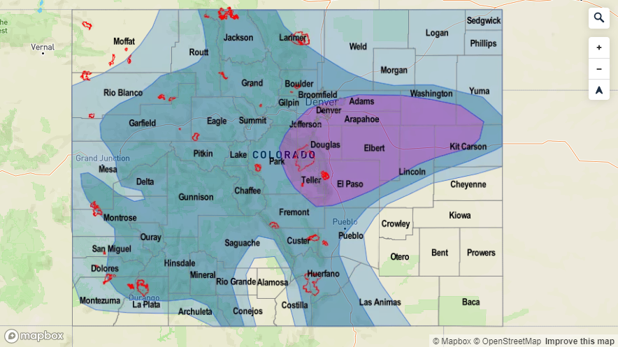
Relief from the heat is almost here with the cold front moving through the state on Tuesday morning. Highs will still likely reach the 90°Fs over the far Southeast Plains, but temperatures should drop into the 80°Fs over the Northeast Plains with 80°F for the Urban Corridor. Gusty winds (35 to 40mph) will likely accompany the front, so you will know when it’s passing overhead. Overcast skies and warm air aloft should help keep the plains capped, so heavy rainfall is not anticipated at this time. Best chance for rainfall will be over the Front Range and eastern San Juan Mountains. On Wednesday, the flood threat increases with a small PW surge, mid-level energy and slow steering winds combining during the afternoon and evening hours. Best chance for heavy rainfall will be over the southern Front Range/Palmer Ridge intersect and San Juan Mountains. The 416 burn area will also need to be monitored closely. Threats include mud flows, debris slides and local stream flash flooding for storms that produce a half inch or greater over the burn area.

Event #2: Thursday (9/5) – Monday (9/9)
High to No Apparent Threat with the High threat on Friday evening focused over the eastern plains.
Expecting several cold fronts to pass through the area during this time period, which combined with moisture will cause the flood threat to return. Thursday, it looks like western Colorado will be the target of the heavy rainfall threat with widespread showers and thunderstorms returning to the forecast. By Friday, the threat returns to all of the high terrains, and also spreads into the adjacent eastern plains. Severe weather may be possible over the eastern plains (right now models are focused on the Palmer Ridge), but at this time, the threat doesn’t look too widespread. The slower storm motion will be the main cause of the High threat. Again, High threat in the FTO means there will likely be more than a Low flood threat issued in the FTB. Heavy rainfall will likely continue on Saturday with the southern high terrains mostly under the gun with post frontal upslope flow. The recent burn areas over the Southeast Mountains will need to be watched closely. Of course, there will be more confidence and details in Thursday’s FTO, so be sure to tune in! Sunday into Monday, the next dry air plume looks to move overhead, which should decrease storms activity. Isolated to scattered thunderstorms over the high terrains will still be possible during the afternoon and evening with the residual moisture.