Issue Date: Thursday, September 5th, 2019
Issue Time: 2:45PM MDT
Valid Dates: 9/6 – 9/20
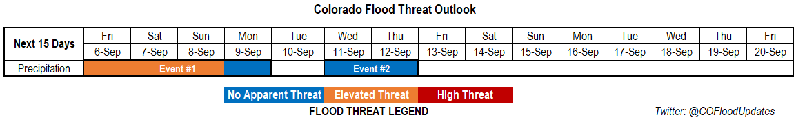
Finally, the high pressure that has been producing the above average temperatures will begin to break down as a series of troughs move through the western US. This more seasonal pattern will bring cooler temperatures and rainfall back into the forecast, which is probably welcomed by everyone at this point. The heavy rainfall threat returns to Colorado tomorrow after a cold front moves through the eastern plains this evening and helps return low level moisture (Event #1). There will likely be some high clouds behind the front and models indicated some light rainfall over the Northeast Plains tomorrow morning. Moisture remains high over eastern Colorado and elevated over the mountains for the duration of this event, and multiple troughs moving through the area at the same time will cause an Elevated threat to be issued through Sunday. Not quite as much moisture over western Colorado on Friday and Saturday, but there should be enough moisture for isolated afternoon showers and weak thunderstorms over the high terrains during the afternoon. The best chance for statewide rainfall accumulation will be on Sunday as a strong trough moves eastward just to our north.
The ridge begins to slightly build back over the state at the beginning of next week, which should pull in a dry air mass with westerly and southwesterly flow aloft. Thus, precipitation chances decrease until the next trough moves through sometime on Wednesday or Thursday (Event #2). Not very confident on the timing of this, but it will be a quick moving system. The GFS oscillates back and forth with the amount of moisture associated with this system, which is likely related to the changing strength and location with each run. However, due to the quick pace of the trough, there is Apparent Threat for Event #2 at this time.
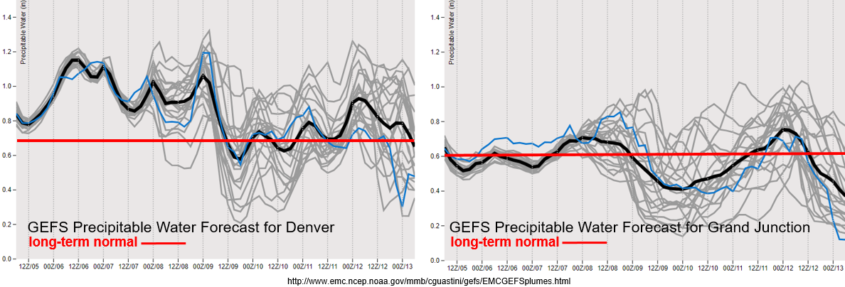
PW over Denver is very elevated (for this time of year) during Event #1 with a slight decrease in moisture between the two passing shortwaves. To the west, not much change, which is to be expected with the high’s location. Expect more of the same for western Colorado for Event #1, but a slight increase in storm coverage on Sunday. Model members are trending downward in PW after the weekend both east and west, thus the decrease in flood threat. As for Event #2, quite a bit of spread in the models, which means it is a low confidence forecast. Please tune back into the FTO on Monday as details will likely become clearer.
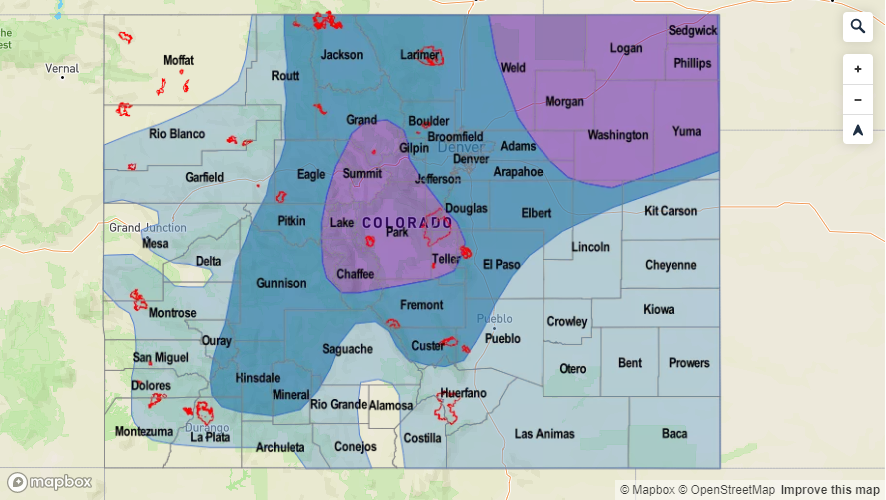
Event #1: Friday (9/6) – Monday (9/9)
Elevated Threat as moisture returns to the mountains and eastern Colorado along with multiple shortwaves forecast to move through the westerly flow.
A cold front moves through the eastern plains tonight, which should return quite a bit of low level moisture. Guidance indicating some light showers may be possible over the Northeast Plains tomorrow morning, but at the least, there will be cooler temperatures and cloud cover behind the front. The heavy rainfall threat returns with more numerous and stronger storms anticipated over the higher elevations tomorrow afternoon. Storm totals over the mountains will likely be between 0.5 and 1 inch for the stronger storms or where multiple storms track over the same area. As storms move into the adjacent plains, unsure what the environment will look like. If the plains are capped or have limited instability (morning cloud cover doesn’t burn off early enough), not thinking a heavy rainfall threat will exist. We’ll also have to look at where the shortwaves are in tomorrow’s water vapor imagery to see if they could help break the cap over the plains.
On Saturday, there is a chance for some severe thunderstorms over the Northeast Plains (and heavy rainfall) with more coverage of storms over the mountains. Threats for the severe thunderstorms include severe hail, strong winds and localized flooding. Over the mountains, recent burn areas will also need to be watched closely. Sunday is now looking like the best chance for statewide rain and heavy rainfall. Once again, recent burn areas will need to be monitored closely.

Event #2: Wednesday (9/11) – Thursday (9/12)
No Apparent Threat as a quick moving, possibly strong trough moves across the state on one of these days. Behind the trough, large scale subsidence should cause a break in rainfall chances.
Not a ton of confidence in this forecast yet as it is a bit far out to judge the timing, strength, and location of the next passing trough. Temperatures will likely more seasonable during this period with a slight increase on Monday and Tuesday with the building high pressure. If this a strong trough, as the latest model runs have been indicating, high temperatures may drop into the low 70°Fs behind the front. Otherwise, looking at highs behind the system to reach the 80°Fs and 70°Fs over the mountains and higher elevation valleys, respectively.