FTO 09-26-2019: Strong Low Digs South Over the West Coast and Returns Shower/Critical Fire Weather for the Weekend

Issue Date: Thursday, September 26th, 2019
Issue Time: 1:30PM MDT
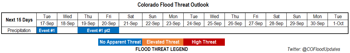
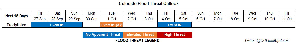
Valid Dates: 9/27 – 10/11

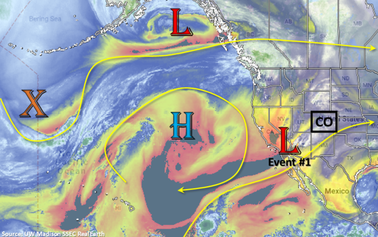
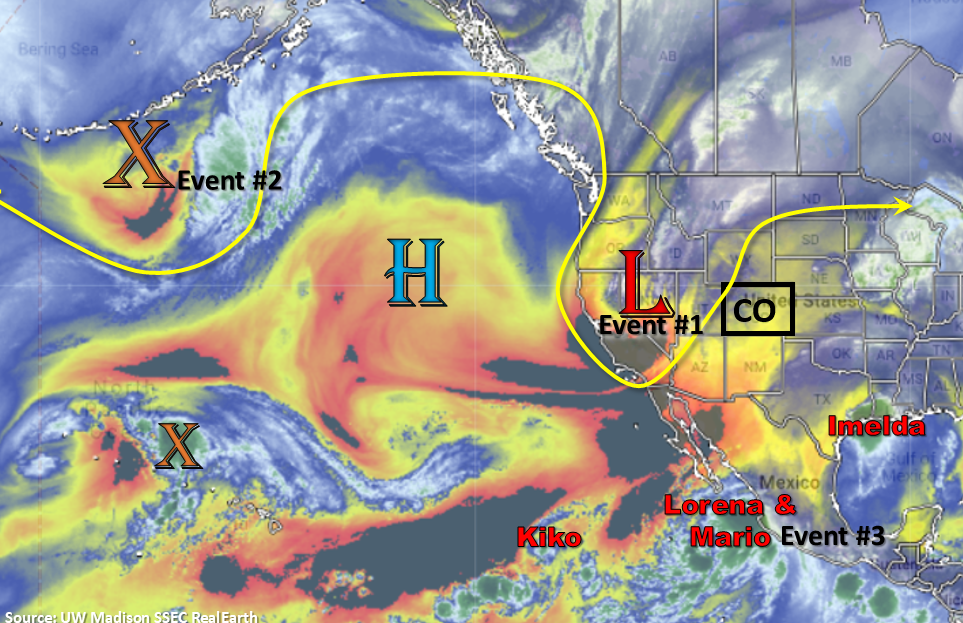
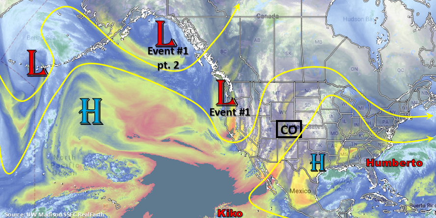
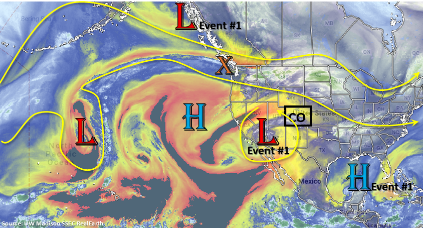
The cut off low is currently over southern CA and has been sitting there the last couple of days, which has helped produce some severe weather over southern Arizona. This feature will lift a little north today before starting to move east across NM Thursday night into Friday. It will be responsible for the increased shower activity tomorrow afternoon and overnight for southern Colorado. On Saturday, the soon to be open wave will lift to the northeast over OK/KS as it gets absorbed into the southwest flow created by the next trough digging south over the west coast.

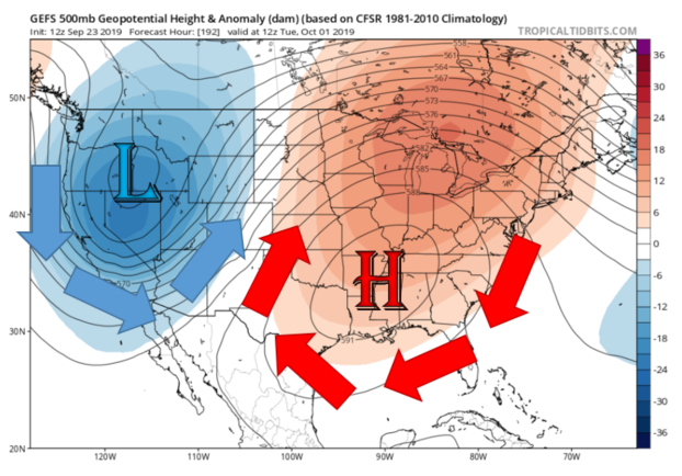
The new low pressure system is marked in the water vapor imagery below along the coast of British Columbia. From late this weekend into mid-next week, this low will set up a dry slot and strong southeasterly flow over the majority of the state. This is expected to return critical fire weather conditions on starting on Sunday, ramping up on Monday and possibly lasting through Wednesday. This is due to a southwest to northeast oriented jet (very tight gradient with the strong low) being present over the state from Saturday evening to Wednesday evening. Sometime on Monday night into Tuesday a surface low sets up over the eastern plains and will develop a dryline with a strengthening high pressure over the southeastern US, which will pull in a very moist air mass. Depending on the location of the surface low (and associated dryline), this feature could bring some heavy rainfall to far Southeast Plains on Monday night into Tuesday. Thus, the Elevated flood threat continues to be issued. Without much break between the two systems, I have lumped Event #1 into a two part event due to the overlapping dynamics.

Lastly over the last couple of days, the GFS runs have started to show a late season PW surge sometime during the first weekend in October. This is likely associated with an increase in tropical activity. While it is a bit too far out to determine if the surge is realistic, it is still worth mentioning since the Flood Threat Bulletin is almost over for the 2019 season. At this time there is No Apparent Threat due to the lack of details and likeliness they will change. Please tune back into the FTO on Monday as there may be some clarity for this event. Reminder the Flood Threat Bulletin ends on September 30th (Monday), but Special FTB Bulletins will be issued if a threat is needed throughout the first half of October.

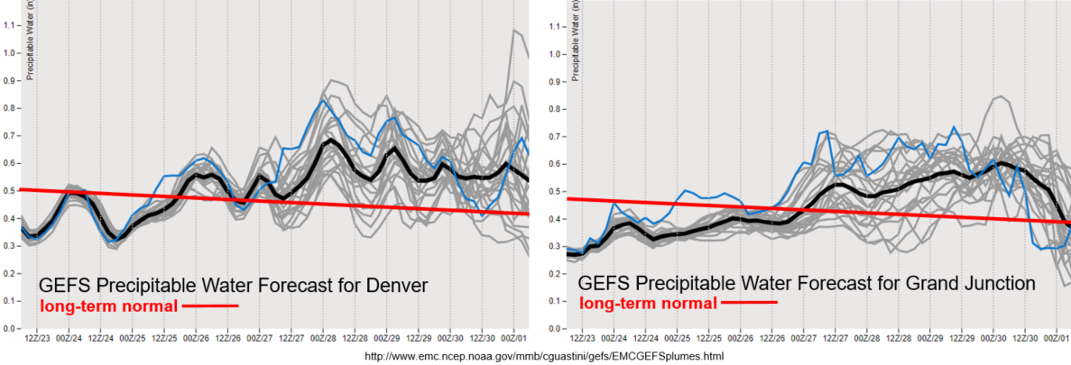
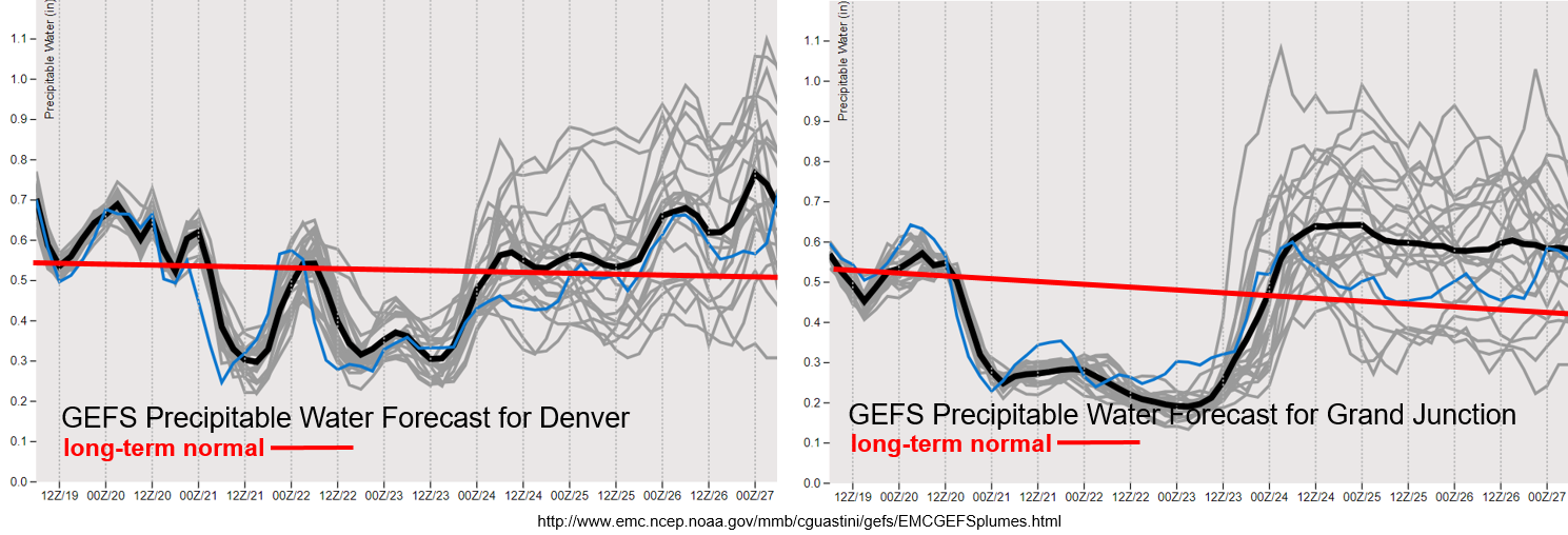
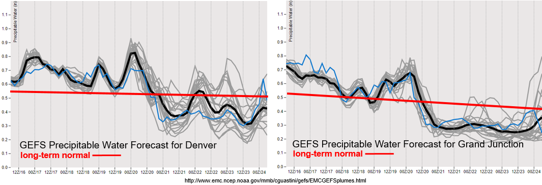
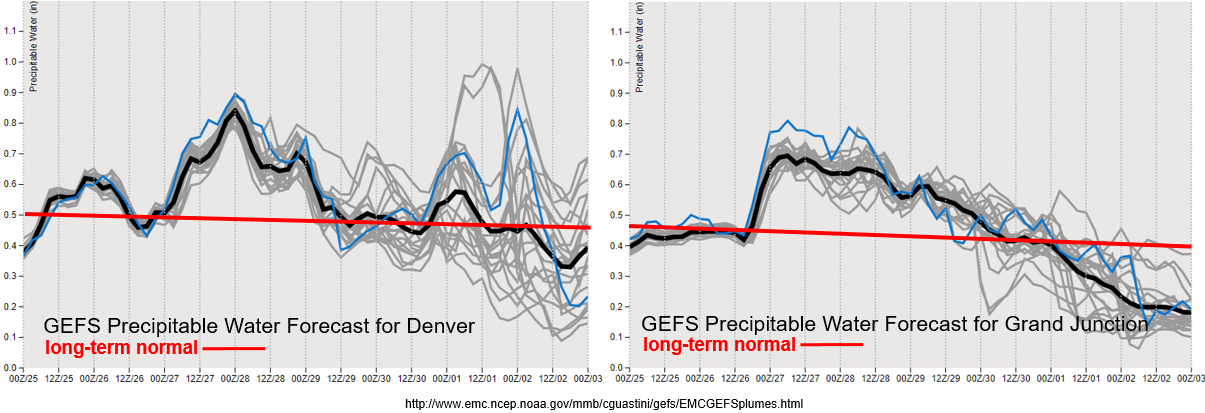
Due to a scheduled supercomputer outage, the GEFS plumes webpage was not updated after the 00Z run on September 25th. The next schedule run is 12Z September 27th (Friday morning), so please note that the GEFS plumes below are not up to date. The first PW surge seen below is associated with the cut off low becoming an upper wave and a weak cold front dropping through the plains overnight tonight. As the low moves eastward tomorrow and ejects mid-level energy and moisture northward, storm chances return to mountains. Some storm activity is likely over the adjacent plains due to westerly steering flows aloft, but dry air in the low levels will likely produce more gusty winds than rainfall. Overnight rainfall over the northwest corner and northern high terrains may be possible with upper dynamics helping aid in lift as the trough digs south. With PW above 0.7 inches, a few areas may receive up to 0.25 inches by morning. After Event #1, PW starts to drop off drastically, which should limit rainfall chances from Sunday into Monday. Scattered to isolated storms will still be possible over the mountains on Sunday as there will likely be pockets of residual moisture remaining intact.

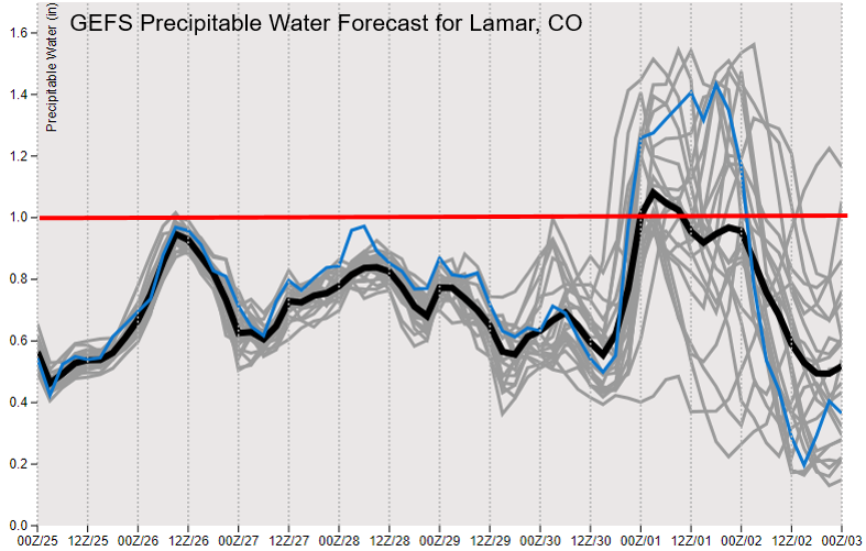
For Event #1 part 2, model runs have been very variable as to where they set up a dryline on Monday night into Tuesday over the Southeast Plains. Some runs have the moisture well to the east and south, while others place some very high values over the southeast corner of the state. Below the Denver and Grand Junction plumes is the GEFS PW plume for Lamar (bottom panel). The red line marks 1 inch, and the Event #1 Part 2 can be seen at the end of the time series. Some model members have PW as high as 1.5 inches, which would translate to very heavy rainfall for the far Southeast Plains Monday night into Tuesday. However, some models members keep PW near an inch or below. Due to the continued inconsistency between model runs, only an Elevated Flood Threat has been issued. The FTO Monday should offer some better insight to the event, so be sure to tune back in.

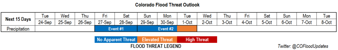
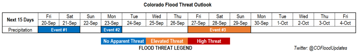
Event #1: Friday (9/27) – Tuesday (10/1)

No Apparent Threat/Elevated Threat as the cut off low begins to move east and the next trough digs south over the west coast.

Not too much more to mention here, since there is a lot of discussion above. Expect an increase in shower activity over the high terrains tomorrow with activity spreading into the adjacent plains (Urban Corridor, Northeast Plains and Palmer Ridge) with westerly steering flows. Storms will likely have high-bases due to lack of low level moisture, so gusty winds will be more likely than accumulating rainfall. Overnight, light rainfall may be possible for the northern mountains and Northwest Slope/Grand Valley. With colder temperatures, a light dusting of snow may be possible over the highest elevations of the northern mountains. Lack of moisture and more gradual rain rates after sundown will mean there is No Apparent Flood Threat issued. Residual moisture on Saturday and Sunday will allow for some scattered pops over the high terrains, but a drier air mass associated with the southwest flow will limit those chances on Monday. Overnight temperatures will start to get cool on Sunday and Monday night for western Colorado with overall cooler temperatures statewide forecast to start next week. Highs will really start to drop off Tuesday and Wednesday.

Fire concerns begin as early as Sunday afternoon and last as long as through Wednesday (when the trough exits the state) with the strong low pressure system creating a tight gradient. However, cooler temperatures to start next week may limit the Critical Fire conditions. Additionally over the Southeast Plains, a dryline will set up on Monday afternoon with a surface trough. This may allow some very heavy rain to fall on Monday night into Tuesday if the higher PW values make it into the area. Thus, the Elevated Threat for this portion of the event. Severe weather may also be possible with a high shear/CAPE environment over this region, but there is equal chance the dryline sets up to our east.


Legend

Event #2: Friday (10/4) – Saturday (10/5)

No Apparent Threat as a late season PW surge may occur from enhanced tropical activity.

Confidence is very low for this event, so choosing not to draw a map below. Just thought it was worth mentioning since the season is going to come to a close soon. Enhanced tropical activity may cause some high PW value to sneak in over Colorado sometime at the end of next week (1st week in October). If the PW is able to remain concentrated and arrives at peak heating, there is a chance for some heavy rainfall. Some model runs keep this moisture over the far eastern plains, while some pull it back west into the Urban Corridor. A couple runs show enough of an increase over the southwest corner that there may be burn scar flooding concerns (416/Burro). But as mentioned above, confidence is too low to draw any definite conclusions as this time. Be sure to tune back in on Monday as it is very likely there will be changes to this forecast.

FTO 09-23-2019: Dry Work Week with Rainfall Chances Increasing Next Weekend

Issue Date: Monday, September 23rd, 2019
Issue Time: 2:10PM MDT
Valid Dates: 9/24 – 10/8

Taking a look at the water vapor imagery below, there is a strong high pressure ridge over the Pacific Ocean. To the east of the subtropical high, over southern California, is a soon-to-be cut off low. This cut off low will sit over this same general area throughout the week, but finally begin to move eastward across New Mexico overnight on Thursday. Until then, Colorado will be under the influence of a very dry air mass with little chance for rainfall. Expect flow aloft to be more northwesterly/westerly for this period with temperatures still slightly above average. Event #1 begins on Friday as the low traverses east with a plume of moisture arriving from the northwest. Moisture remains over the region through Saturday, but a surface low sets up near the CO/KS border. This should limit the rainfall over southern Colorado (downsloping winds) and keep scattered storms in the forecast over the northern high terrains and adjacent plains for Saturday.

Event #2 begins immediately following Event #1 as a low begins to deepen over the Great Basin. By Monday, quite a strong low pressure system looks to set up just to our west. Meanwhile, a subtropical high begins to strengthen over the southeast. The subtropical high will pull in a very moist air mass (origins: Gulf of Mexico), while the low will pull in a very dry air mass (origin: Desert Southwest). Thus, where this convergence boundary forms, very high PW values will be on the east side and very low PW values will be on the west side. Below is the GEFS height anomaly from the 12Z valid Tuesday morning (which sets up this boundary to our east). Still a lot of uncertainty where these features will set up precisely, but if the higher PW values end up over the eastern plains, some very heavy rainfall is likely. As seen below, there is equal chance at this point that the higher PW values set up to our east. We will be watching this closely over the next week, but an Elevated Flood Threat continues to be issued for Event #2, which includes post frontal upslope flow when the trough moves eastward. Just a reminder that Thursday is the last FTO for the season, but the FTB will be extended as needed for heavy rainfall events in (early) October.

PW is well below average both east and west of the Continental Divide to start the week with the dry air mass overhead. Expecting this value to briefly increase over the southern border of Colorado this afternoon with a slight upward trend in PW values over the next couple of days. Still quite dry, so rainfall is not anticipated, but we could get some better afternoon cloud cover by Thursday. The jet remains to the north of Colorado for this period, so Critical Fire Weather is not forecast at this time. As Event #1 begins, rainfall chances return with PW values rising to/slightly above climatological values. Coverage will likely be more scattered in nature with Saturday favoring the high terrains to the north and Northeast Plains. Quite a bit of spread in PW values between model members, which could favor/hinder more widespread coverage of the measurable rainfall.

Event #1: Friday (9/27) – Saturday (9/28)

No Apparent Threat as the cut off low begins to move east.

A quick moving shortwave from the north looks to add some moisture to the state as it move to the southeast, which will coincide with the cut off low transitioning east. This should bring showers and weak thunderstorms back into the forecast for Friday and Saturday. Friday will likely favor the southern half of Colorado due to the mid-level energy overhead. Storms are expected to move into the adjacent plains with westerly steering flow, but flooding is not forecast at this time. The Spring Creek burn area may need to be monitored closely on Friday as well; along with the 416 and Lake Christine burn areas. We will keep watching the path and timing of the cut off low (variable run to run still) as this will likely dictate storm speed, coverage and moisture return over certain areas. Saturday, a surface low develops over the eastern plains, which will help keep moisture in place to its north, but scour out remaining moisture to the south (downsloping winds). There is No Apparent Flood Threat for Event #1.

Legend

Event #2: Sunday (9/29) – Tuesday (10/1)

No Apparent Threat/Elevated Threat as a deepening low to our west and strengthening high to our east combine for a (possible) late season PW surge.

Confidence is still lower for Event #2 of this FTO. There will very likely be a moisture surge if the strong trough/ridge pattern sets up. However, quite a bit of uncertainty still about where and when this boundary will set up. If it sets up over eastern Colorado, some very heavy rainfall will be likely. There is equal chance it will set up to our east (as in the latest model runs). It all depends on the strength, timing and location of the trough/ridge pattern, which is difficult to pinpoint this far out. Nonetheless, thinking there will be scattered storms returning to the state sometime during this period. This is especially true for the mountains after the trough moves through and drops a cold front through the state (post frontal upslope flow). The Elevated Threat extends to the post frontal upslope flow as well, which is currently focused over the Front Range. Timing of the event may also shift a day or two in Thursday’s FTO, so be sure to tune back in. Due to strong inconsistency between model runs for this event, no precipitation map has been drawn.


FTO 09-19-2019: Scattered Afternoon Showers & Thunderstorms Forecast for Friday, then a Drying Trend Heading into this Weekend

Issue Date: Thursday, September 19th, 2019
Issue Time: 1:20PM MDT
Valid Dates: 9/20 – 10/4

Active FTO with 3 events, although there is No Apparent Threat for Event #1 and #2 as quick moving upper level disturbances push through the state. Look at the water vapor imagery below, there is a lot of tropical activity right now. There is a chance that Tropical Cyclones Mario and Lorena get pulled into the westerly flow of Event #3 (a low deepening over the Great Basin). The high pressure over the Pacific is fairly consistent through this period, and builds off the coast of California after Event #2. This will keep the flow more amplified and help produce northwesterly and westerly flow aloft over the state, which should keep temperatures more seasonable. Especially when compared to the last couple of weeks. Guidance showing building high pressure to the west and east of the trough for Event #3 that drops south and sets up somewhere over the Great Basin. This will help keep the low in place for a longer period of time, which may help pull a nice subtropical plume northward over the state. Thus, the Elevated Threat, although there is low confidence in the models this far out.

PW looks to drop off from west to east after Friday with the main axis of the trough moving to the northeast of the state. There is a slight moisture return behind a cold front for far eastern Colorado on Friday night, so there is still a chance for some scattered afternoon storms for this area if the shortwave passes overhead at peak heating. Expecting some strong south and southwest surface winds on Friday, and with a dry air mass overhead, critical fire weather is likely. Please tune into the FTB as this will be covered in the daily discussion. PW looks to rebound ahead of the next trough (Event #2), although the GEFS is showing quite the spread between the ensemble members. Rainfall looks more promising for the western high terrains with more scattered activity anticipated for eastern Colorado and the adjacent plains. Surface winds will likely increase as well with the tightening gradient, so if moisture return is on the lower end, there may be pockets of enhance fire weather on Monday. Unsure what PW will do after Event #2, but if it’s on the lower end, critical fire weather may return as portions of the jet move overhead on and off throughout the week.

Event #1: Friday (9/20) – Saturday (9/21)

No Apparent Threat as a trough lifts to the northeast with minimal PW return behind a cold front.

Event #1 begins with the trough to our west, which will pull to the northeast tomorrow afternoon. This will brush the northwest corner of the state and northern mountains bringing with it more wind than measurable rain. Scattered rainfall is anticipated over the northern high terrains with a dry air mass quickly moving in behind it. A surface trough sets up over eastern Colorado, so some severe weather may be possible over the Southeast Plains along a dryline. Unsure where the dryline will set up as there is equal chance it is in Kansas. Nonetheless, should storms form in Colorado, they should be moving fast enough with the jet overhead that flooding will be avoided. Max 1-hour rain rates up to 1.25 inches may be possible. Overnight, a cold front drops south, which returns a little moisture to eastern Colorado on Saturday. A second wave moves through the state sometime on Saturday, so a few weak thunderstorms and showers may be possible over the far eastern plains if the cap can break. Thus, we’ll need subsidence to be on the lower side and the wave passing overhead at peak heating. Another cold front drops through the eastern plains on Saturday evening behind the trough, which may bring additional light showers and overnight cloud cover to the plains. The ridge begins to rebuild on Sunday, and with a dry air mass in place, rainfall is not anticipated. Should be a cooler period with temperatures closer to seasonal values.

Legend


Event #2: Monday (9/23)

No Apparent Threat as a quick moving pushes from the northwest to the southeast across the state. Scattered storms are anticipated for the mountains, favoring the western high terrains.

Another quick moving trough looks to slide through on Monday afternoon. There looks to only be a slight increase in moisture with the system, but it should be enough to return showers and thunderstorms to the forecast over the western high terrains. There is a slight jump in PW over eastern Colorado as well, so perhaps the mountains and adjacent plains can see a little rainfall activity. Cool, dry air moves in behind the fast moving trough, then it looks to remain quiet through the end of next week. Northwest/west flow aloft during this period should keep high temperatures down. Fire weather may be likely if PW values drop off due to the jet overhead or near the northern border.

Legend


Event #3: Friday (9/27) – Sunday (9/29)

Elevated Threat as a trough digs south and sits over the Great Basin. This could create a PW surge over the state, which may last a couple of days.

Confidence is very low for Event #3 as a low looks to dig south and sit somewhere over the Great Basin. Unsure about where the low will sit (and for how long) with guidance slightly different each run. It looks like remnants of Tropical Storm Lorena/Mario may get pulled into the system if the track is further south. With a deepening low, if upper level flow can turn more southerly over Colorado, there could be a nice subtropical moisture plume advected northward for an extended period of time. While a lot of details can change, it’s worth mentioning and issuing an Elevated Flood Threat at this time. PW could remain elevated past Sunday, so be sure to tune in next week to follow this developing system. The map below is my best guess from the latest couple of GFS run assuming there is a PW surge. Reminder, the last FTO will be next Thursday, but the FTB will be extended beyond September 30th as needed.

Legend

FTO 09-16-2019: Two Quick Moving Troughs Return Rainfall Chances and Cooler Temperatures

Issue Date: Monday, September 16th, 2019
Issue Time: 1:40PM MDT
Valid Dates: 9/17 – 10/1

Temperatures have been above normal with the high pressure dome over the state the last couple of days. This helped keep weather relatively rain-free since the last FTO. The exception is over the southwest corner of the state where a passing shortwave in the flow help produce some much needed rainfall on Sunday and again today. Isolated totals over the southeastern San Juan Mountains were just over an inch this morning with another round of rain expected today/tonight. Due to the quickness and lack of strength of the two events in this FTO, they have been grouped into one event. The first event begins overnight tonight as the trough moves northeastward and brushes the northwest corner of the state tomorrow afternoon. This looks to mostly affect the western high terrains and Northwest Slope. Behind the first trough, subsidence and a cold front Tuesday night should keep Wednesday rain-free with much more seasonable temperatures anticipated statewide. Some light, overnight showers will also be possible over the eastern plains on Tuesday night as the front drops south. Also, forecasting surface winds to turn from more southwesterly (west) to more westerly statewide over this time period as the trough approaches. Surface wind speeds are forecast to increase as well (20-30 mph) with the tightening gradient.

The next trough moves through the flow in similar fashion to Event #1 (Event #1 pt2) sometime on Thursday or Friday. This should return rainfall chances to the forecast. The timing of the trough’s passage will determine how much rainfall coverage there will be. If it passes through during peak heating, expect slight higher rain rates and coverage than if it passes through overnight. Behind the trough, a very dry air mass will fill in with another cold front pushing south on Friday night. With lower PW and a jet overhead (fast storm speed), there is No Apparent Flood Threat at this time. Storm chances return sometime at the beginning of next week (briefly) as the 500mb high sets up over the desert southwest. This will produce northwest flow aloft over the state and push another front through the eastern plains. A very dry air mass looks to fill in behind this, so it’s not looking like there is any heavy rainfall threat in the near future.

PW looks to remain elevated (above climatology) both east and west of the Continental Divide through Thursday/Friday. There’s a slight moisture increase with both of the troughs that move through, but nothing too spectacular. With PW looking to remain well below 1 inch, there is No Apparent Threat at this time. However, scattered afternoon showers over the high terrains is likely for this period (minus Wednesday). Not too worried about burn scars at this time, but the Lake Christine and 416 burn area will be watched closely on Thursday. Any threats needed will be added to the FTB.

It gets really dry going into Friday/next weekend with high temperatures doing a nice rebound from Sunday into Monday. PW drops to the 10th percentile if the forecast below verifies. With vegetation already dried out from the abnormally dry and hot weather, please use extra caution with anything that could spark a flame. While Red Flag Warning criteria does not look to be met for a prolonged period of time, there is still Elevated fire danger for this reason. A brief period of critical fire weather over the mountains will be possible on Friday afternoon before the trough fully exits to the east.

Event #1: Tuesday (9/17) – Friday (9/20)

No Apparent Threat as two troughs lift northward across Colorado and increase PW values enough for some brief, high elevation measurable rainfall.

There will be two quick rainfall events during this period as a couple troughs lift to the northeast. Not looking like either event will be more than one day with cool temperatures, dry air and subsidence filling in behind both. Right now, timing is making this look more like a western Colorado event, although that could change over the next couple of runs for Event #1 pt. 2. Expect an increase in surface winds as well as the troughs move though and tightens the gradient with the jet also possibility mixing down stronger winds to the surface. This may cause some critical fire weather (on top of dry vegetation) if dry air moves in before the jet moves out. Storms during this event are looking to be relatively high-based, so brief, strong winds will be possible along with small hail for the stronger thunderstorms. For eastern Colorado, the best chance for a couple thunderstorms will be over the Southeast Mountains and Raton Ridge on Thursday afternoon. There doesn’t look to be a severe threat over the plains as better thunderstorm parameters will be in Kansas.

Legend