Issue Date: Monday, September 16th, 2019
Issue Time: 1:40PM MDT
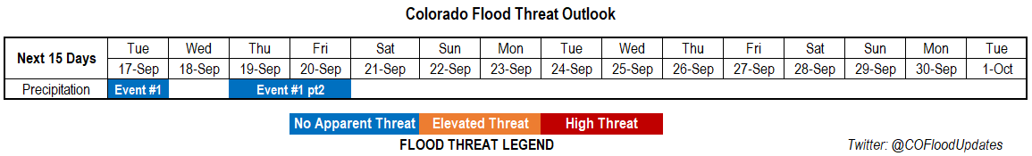
Valid Dates: 9/17 – 10/1
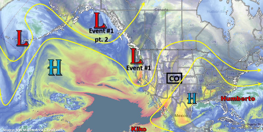
Temperatures have been above normal with the high pressure dome over the state the last couple of days. This helped keep weather relatively rain-free since the last FTO. The exception is over the southwest corner of the state where a passing shortwave in the flow help produce some much needed rainfall on Sunday and again today. Isolated totals over the southeastern San Juan Mountains were just over an inch this morning with another round of rain expected today/tonight. Due to the quickness and lack of strength of the two events in this FTO, they have been grouped into one event. The first event begins overnight tonight as the trough moves northeastward and brushes the northwest corner of the state tomorrow afternoon. This looks to mostly affect the western high terrains and Northwest Slope. Behind the first trough, subsidence and a cold front Tuesday night should keep Wednesday rain-free with much more seasonable temperatures anticipated statewide. Some light, overnight showers will also be possible over the eastern plains on Tuesday night as the front drops south. Also, forecasting surface winds to turn from more southwesterly (west) to more westerly statewide over this time period as the trough approaches. Surface wind speeds are forecast to increase as well (20-30 mph) with the tightening gradient.
The next trough moves through the flow in similar fashion to Event #1 (Event #1 pt2) sometime on Thursday or Friday. This should return rainfall chances to the forecast. The timing of the trough’s passage will determine how much rainfall coverage there will be. If it passes through during peak heating, expect slight higher rain rates and coverage than if it passes through overnight. Behind the trough, a very dry air mass will fill in with another cold front pushing south on Friday night. With lower PW and a jet overhead (fast storm speed), there is No Apparent Flood Threat at this time. Storm chances return sometime at the beginning of next week (briefly) as the 500mb high sets up over the desert southwest. This will produce northwest flow aloft over the state and push another front through the eastern plains. A very dry air mass looks to fill in behind this, so it’s not looking like there is any heavy rainfall threat in the near future.
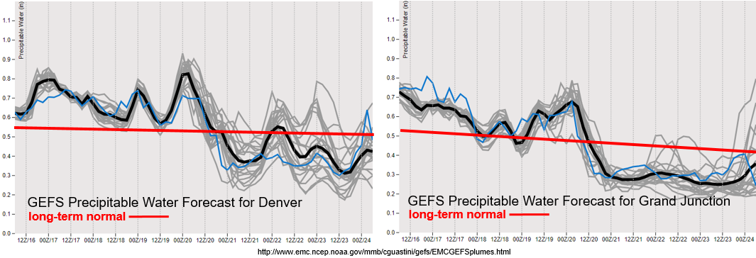
PW looks to remain elevated (above climatology) both east and west of the Continental Divide through Thursday/Friday. There’s a slight moisture increase with both of the troughs that move through, but nothing too spectacular. With PW looking to remain well below 1 inch, there is No Apparent Threat at this time. However, scattered afternoon showers over the high terrains is likely for this period (minus Wednesday). Not too worried about burn scars at this time, but the Lake Christine and 416 burn area will be watched closely on Thursday. Any threats needed will be added to the FTB.
It gets really dry going into Friday/next weekend with high temperatures doing a nice rebound from Sunday into Monday. PW drops to the 10th percentile if the forecast below verifies. With vegetation already dried out from the abnormally dry and hot weather, please use extra caution with anything that could spark a flame. While Red Flag Warning criteria does not look to be met for a prolonged period of time, there is still Elevated fire danger for this reason. A brief period of critical fire weather over the mountains will be possible on Friday afternoon before the trough fully exits to the east.
Event #1: Tuesday (9/17) – Friday (9/20)
No Apparent Threat as two troughs lift northward across Colorado and increase PW values enough for some brief, high elevation measurable rainfall.
There will be two quick rainfall events during this period as a couple troughs lift to the northeast. Not looking like either event will be more than one day with cool temperatures, dry air and subsidence filling in behind both. Right now, timing is making this look more like a western Colorado event, although that could change over the next couple of runs for Event #1 pt. 2. Expect an increase in surface winds as well as the troughs move though and tightens the gradient with the jet also possibility mixing down stronger winds to the surface. This may cause some critical fire weather (on top of dry vegetation) if dry air moves in before the jet moves out. Storms during this event are looking to be relatively high-based, so brief, strong winds will be possible along with small hail for the stronger thunderstorms. For eastern Colorado, the best chance for a couple thunderstorms will be over the Southeast Mountains and Raton Ridge on Thursday afternoon. There doesn’t look to be a severe threat over the plains as better thunderstorm parameters will be in Kansas.