Issue Date: Thursday, September 19th, 2019
Issue Time: 1:20PM MDT
Valid Dates: 9/20 – 10/4
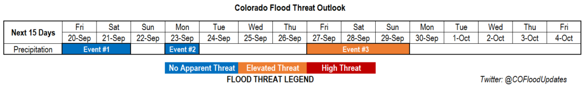
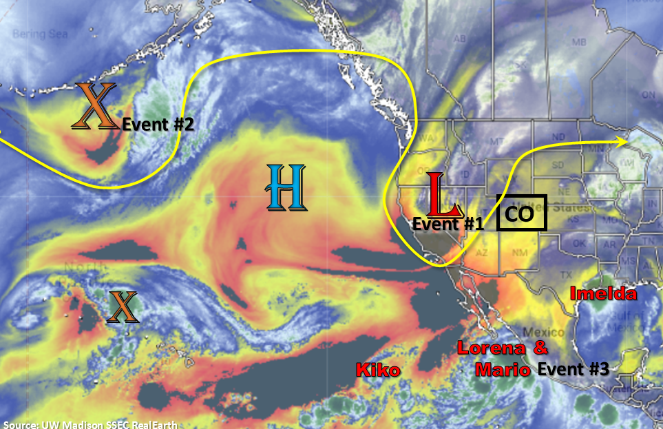
Active FTO with 3 events, although there is No Apparent Threat for Event #1 and #2 as quick moving upper level disturbances push through the state. Look at the water vapor imagery below, there is a lot of tropical activity right now. There is a chance that Tropical Cyclones Mario and Lorena get pulled into the westerly flow of Event #3 (a low deepening over the Great Basin). The high pressure over the Pacific is fairly consistent through this period, and builds off the coast of California after Event #2. This will keep the flow more amplified and help produce northwesterly and westerly flow aloft over the state, which should keep temperatures more seasonable. Especially when compared to the last couple of weeks. Guidance showing building high pressure to the west and east of the trough for Event #3 that drops south and sets up somewhere over the Great Basin. This will help keep the low in place for a longer period of time, which may help pull a nice subtropical plume northward over the state. Thus, the Elevated Threat, although there is low confidence in the models this far out.
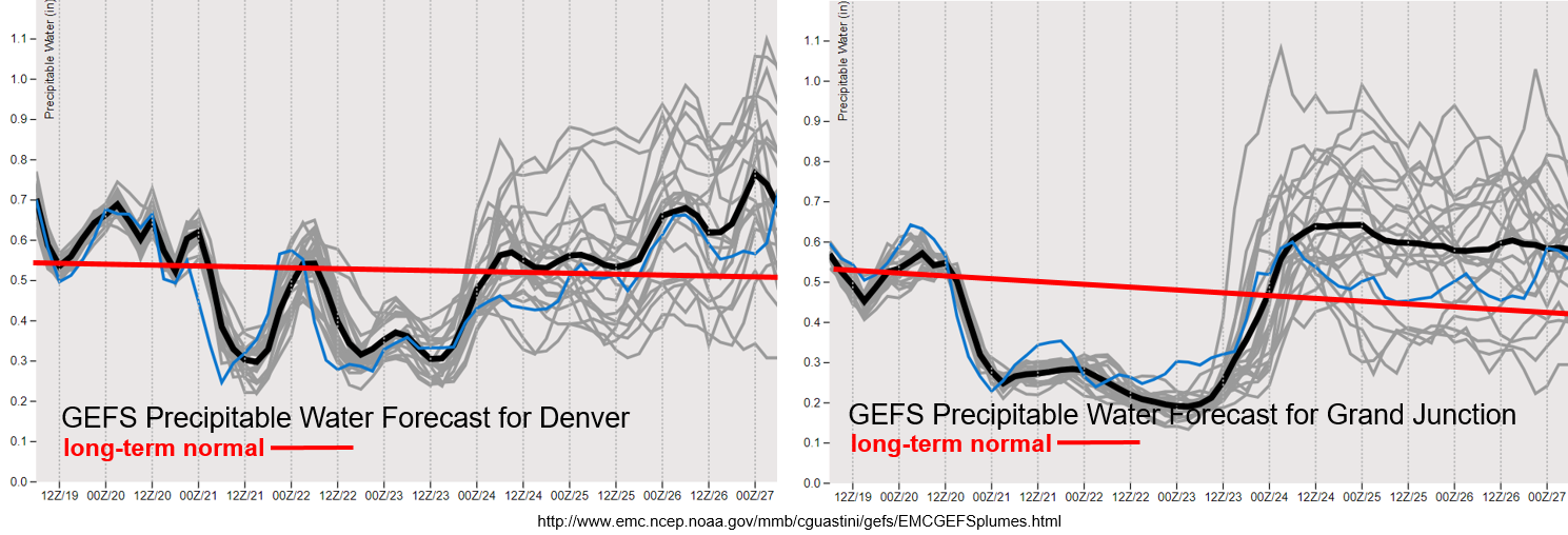
PW looks to drop off from west to east after Friday with the main axis of the trough moving to the northeast of the state. There is a slight moisture return behind a cold front for far eastern Colorado on Friday night, so there is still a chance for some scattered afternoon storms for this area if the shortwave passes overhead at peak heating. Expecting some strong south and southwest surface winds on Friday, and with a dry air mass overhead, critical fire weather is likely. Please tune into the FTB as this will be covered in the daily discussion. PW looks to rebound ahead of the next trough (Event #2), although the GEFS is showing quite the spread between the ensemble members. Rainfall looks more promising for the western high terrains with more scattered activity anticipated for eastern Colorado and the adjacent plains. Surface winds will likely increase as well with the tightening gradient, so if moisture return is on the lower end, there may be pockets of enhance fire weather on Monday. Unsure what PW will do after Event #2, but if it’s on the lower end, critical fire weather may return as portions of the jet move overhead on and off throughout the week.
Event #1: Friday (9/20) – Saturday (9/21)
No Apparent Threat as a trough lifts to the northeast with minimal PW return behind a cold front.
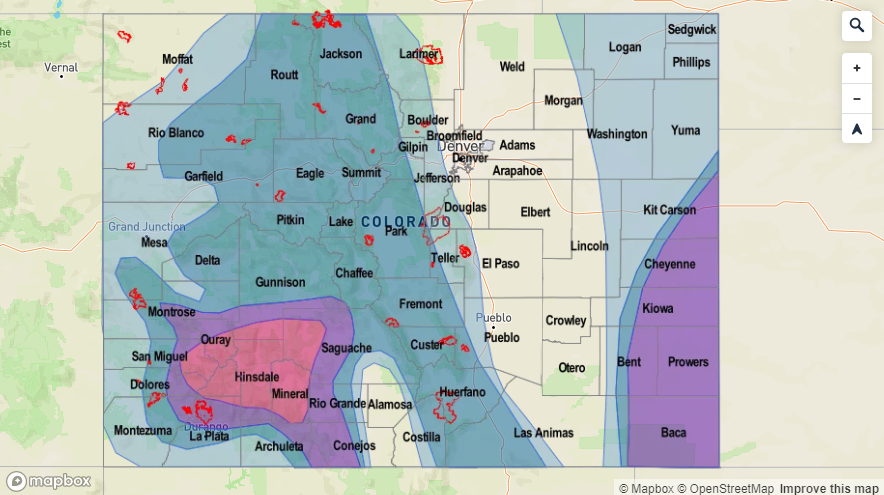
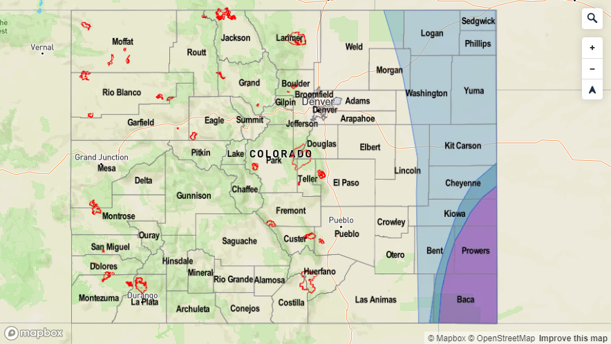
Event #1 begins with the trough to our west, which will pull to the northeast tomorrow afternoon. This will brush the northwest corner of the state and northern mountains bringing with it more wind than measurable rain. Scattered rainfall is anticipated over the northern high terrains with a dry air mass quickly moving in behind it. A surface trough sets up over eastern Colorado, so some severe weather may be possible over the Southeast Plains along a dryline. Unsure where the dryline will set up as there is equal chance it is in Kansas. Nonetheless, should storms form in Colorado, they should be moving fast enough with the jet overhead that flooding will be avoided. Max 1-hour rain rates up to 1.25 inches may be possible. Overnight, a cold front drops south, which returns a little moisture to eastern Colorado on Saturday. A second wave moves through the state sometime on Saturday, so a few weak thunderstorms and showers may be possible over the far eastern plains if the cap can break. Thus, we’ll need subsidence to be on the lower side and the wave passing overhead at peak heating. Another cold front drops through the eastern plains on Saturday evening behind the trough, which may bring additional light showers and overnight cloud cover to the plains. The ridge begins to rebuild on Sunday, and with a dry air mass in place, rainfall is not anticipated. Should be a cooler period with temperatures closer to seasonal values.

Event #2: Monday (9/23)
No Apparent Threat as a quick moving pushes from the northwest to the southeast across the state. Scattered storms are anticipated for the mountains, favoring the western high terrains.
Another quick moving trough looks to slide through on Monday afternoon. There looks to only be a slight increase in moisture with the system, but it should be enough to return showers and thunderstorms to the forecast over the western high terrains. There is a slight jump in PW over eastern Colorado as well, so perhaps the mountains and adjacent plains can see a little rainfall activity. Cool, dry air moves in behind the fast moving trough, then it looks to remain quiet through the end of next week. Northwest/west flow aloft during this period should keep high temperatures down. Fire weather may be likely if PW values drop off due to the jet overhead or near the northern border.
Event #3: Friday (9/27) – Sunday (9/29)
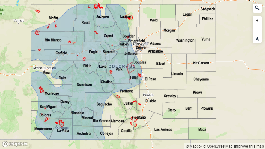
Elevated Threat as a trough digs south and sits over the Great Basin. This could create a PW surge over the state, which may last a couple of days.
Confidence is very low for Event #3 as a low looks to dig south and sit somewhere over the Great Basin. Unsure about where the low will sit (and for how long) with guidance slightly different each run. It looks like remnants of Tropical Storm Lorena/Mario may get pulled into the system if the track is further south. With a deepening low, if upper level flow can turn more southerly over Colorado, there could be a nice subtropical moisture plume advected northward for an extended period of time. While a lot of details can change, it’s worth mentioning and issuing an Elevated Flood Threat at this time. PW could remain elevated past Sunday, so be sure to tune in next week to follow this developing system. The map below is my best guess from the latest couple of GFS run assuming there is a PW surge. Reminder, the last FTO will be next Thursday, but the FTB will be extended beyond September 30th as needed.