Issue Date: Monday, September 23rd, 2019
Issue Time: 2:10PM MDT
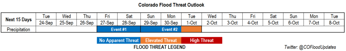
Valid Dates: 9/24 – 10/8
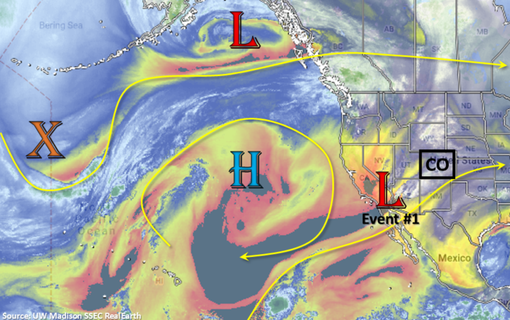
Taking a look at the water vapor imagery below, there is a strong high pressure ridge over the Pacific Ocean. To the east of the subtropical high, over southern California, is a soon-to-be cut off low. This cut off low will sit over this same general area throughout the week, but finally begin to move eastward across New Mexico overnight on Thursday. Until then, Colorado will be under the influence of a very dry air mass with little chance for rainfall. Expect flow aloft to be more northwesterly/westerly for this period with temperatures still slightly above average. Event #1 begins on Friday as the low traverses east with a plume of moisture arriving from the northwest. Moisture remains over the region through Saturday, but a surface low sets up near the CO/KS border. This should limit the rainfall over southern Colorado (downsloping winds) and keep scattered storms in the forecast over the northern high terrains and adjacent plains for Saturday.
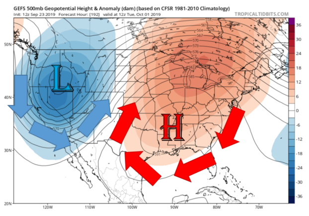
Event #2 begins immediately following Event #1 as a low begins to deepen over the Great Basin. By Monday, quite a strong low pressure system looks to set up just to our west. Meanwhile, a subtropical high begins to strengthen over the southeast. The subtropical high will pull in a very moist air mass (origins: Gulf of Mexico), while the low will pull in a very dry air mass (origin: Desert Southwest). Thus, where this convergence boundary forms, very high PW values will be on the east side and very low PW values will be on the west side. Below is the GEFS height anomaly from the 12Z valid Tuesday morning (which sets up this boundary to our east). Still a lot of uncertainty where these features will set up precisely, but if the higher PW values end up over the eastern plains, some very heavy rainfall is likely. As seen below, there is equal chance at this point that the higher PW values set up to our east. We will be watching this closely over the next week, but an Elevated Flood Threat continues to be issued for Event #2, which includes post frontal upslope flow when the trough moves eastward. Just a reminder that Thursday is the last FTO for the season, but the FTB will be extended as needed for heavy rainfall events in (early) October.
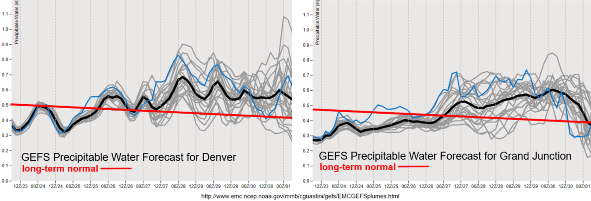
PW is well below average both east and west of the Continental Divide to start the week with the dry air mass overhead. Expecting this value to briefly increase over the southern border of Colorado this afternoon with a slight upward trend in PW values over the next couple of days. Still quite dry, so rainfall is not anticipated, but we could get some better afternoon cloud cover by Thursday. The jet remains to the north of Colorado for this period, so Critical Fire Weather is not forecast at this time. As Event #1 begins, rainfall chances return with PW values rising to/slightly above climatological values. Coverage will likely be more scattered in nature with Saturday favoring the high terrains to the north and Northeast Plains. Quite a bit of spread in PW values between model members, which could favor/hinder more widespread coverage of the measurable rainfall.
Event #1: Friday (9/27) – Saturday (9/28)
No Apparent Threat as the cut off low begins to move east.
A quick moving shortwave from the north looks to add some moisture to the state as it move to the southeast, which will coincide with the cut off low transitioning east. This should bring showers and weak thunderstorms back into the forecast for Friday and Saturday. Friday will likely favor the southern half of Colorado due to the mid-level energy overhead. Storms are expected to move into the adjacent plains with westerly steering flow, but flooding is not forecast at this time. The Spring Creek burn area may need to be monitored closely on Friday as well; along with the 416 and Lake Christine burn areas. We will keep watching the path and timing of the cut off low (variable run to run still) as this will likely dictate storm speed, coverage and moisture return over certain areas. Saturday, a surface low develops over the eastern plains, which will help keep moisture in place to its north, but scour out remaining moisture to the south (downsloping winds). There is No Apparent Flood Threat for Event #1.

Event #2: Sunday (9/29) – Tuesday (10/1)
No Apparent Threat/Elevated Threat as a deepening low to our west and strengthening high to our east combine for a (possible) late season PW surge.
Confidence is still lower for Event #2 of this FTO. There will very likely be a moisture surge if the strong trough/ridge pattern sets up. However, quite a bit of uncertainty still about where and when this boundary will set up. If it sets up over eastern Colorado, some very heavy rainfall will be likely. There is equal chance it will set up to our east (as in the latest model runs). It all depends on the strength, timing and location of the trough/ridge pattern, which is difficult to pinpoint this far out. Nonetheless, thinking there will be scattered storms returning to the state sometime during this period. This is especially true for the mountains after the trough moves through and drops a cold front through the state (post frontal upslope flow). The Elevated Threat extends to the post frontal upslope flow as well, which is currently focused over the Front Range. Timing of the event may also shift a day or two in Thursday’s FTO, so be sure to tune back in. Due to strong inconsistency between model runs for this event, no precipitation map has been drawn.