FTO 05-25-2020: Afternoon Rainfall Returns to the Forecast with Hot Temperatures by Next Weekend

Issue Date: Monday, May 25th, 2020
Issue Time: 1:25PM MDT
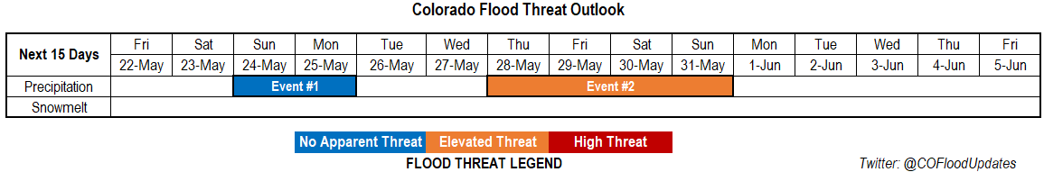
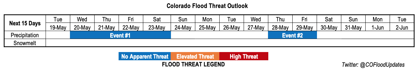
Valid Dates: 5/26 – 6/9

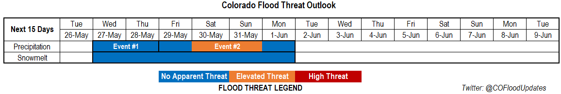
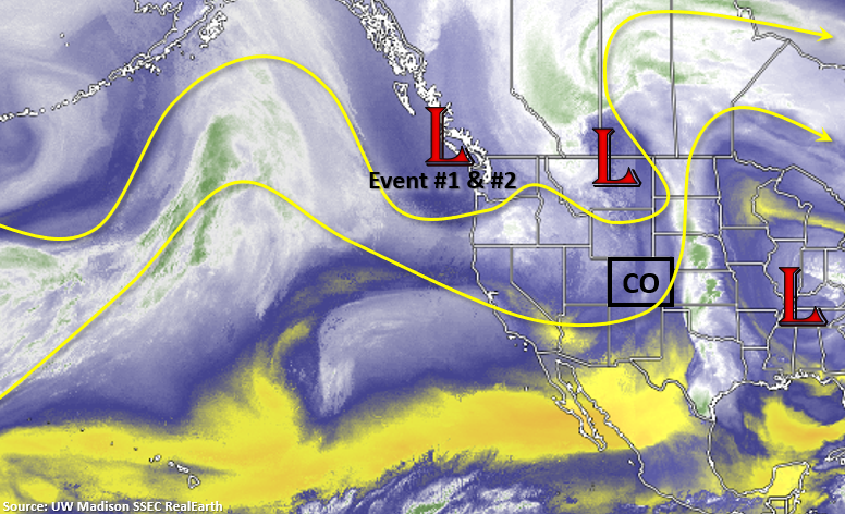
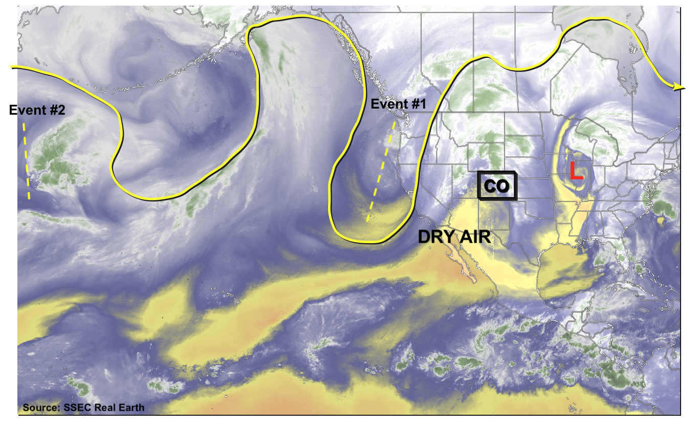
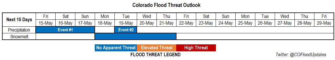
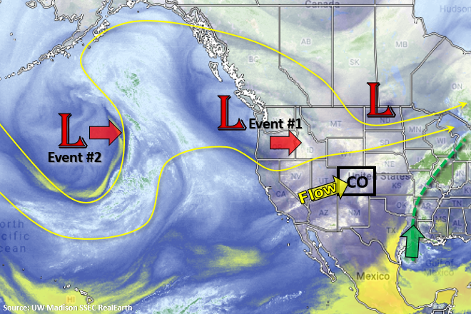
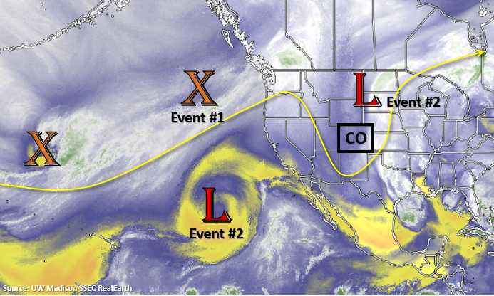
There will be a break from storms on Tuesday before a fairly active rainfall pattern returns to the state through the start of next week. Event #1 begins as the Low to our north moves southeast and allows some mid-level vorticity to slide into the state with northwest flow aloft. Event #2 begins immediately after when the low off the coast of Mexico helps set up an omega pattern, which will place Colorado under the influence of a highly amplified ridge. This will return hot temperatures to the state by next weekend, and decent moisture could work its way up from the south over the as the ridge axis is slightly shifted eastward. Thus, the Elevated flood threat for next weekend.

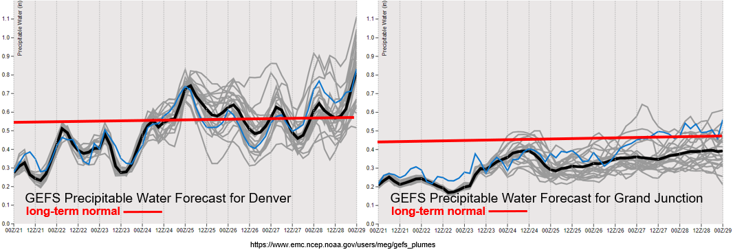
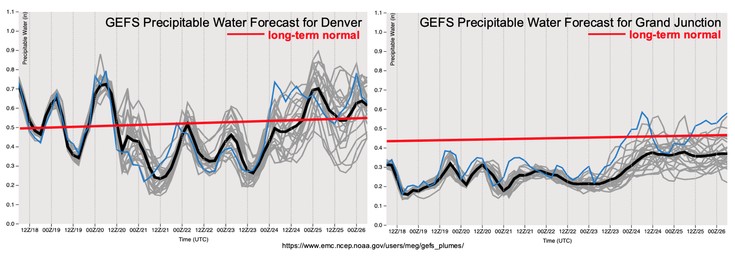
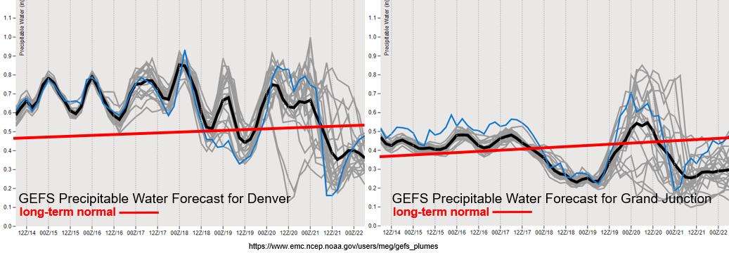
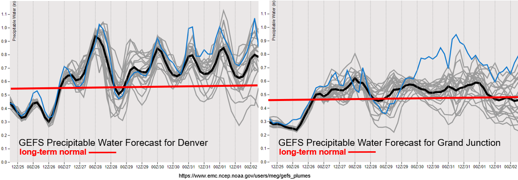
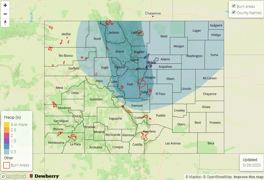
Moisture has a strong return by Tuesday (west) and Wednesday (east) as seen in the PW plumes below. This is particularly true for eastern Colorado where PW increases about three-quarters of an inch in a 36-hour span. Looks like Wednesday could get interesting in regards to rainfall with PW close to an inch, so we’ll be watching the timing of the shortwave passage closely in the daily FTB. Moisture levels stay above average over eastern Colorado through Monday, thus the increase in chances in rainfall for this FTO. Over western Colorado, PW values are slightly less, but are still above climatology through next weekend. This should help lessen fire concerns along with calmer surface winds under the ridge, and bring scattered afternoon storms back into the forecast for the higher terrains. Really hoping the aforementioned moisture surge from the Gulf of Mexico happens for the southwest corner of the state and San Luis Valley region.

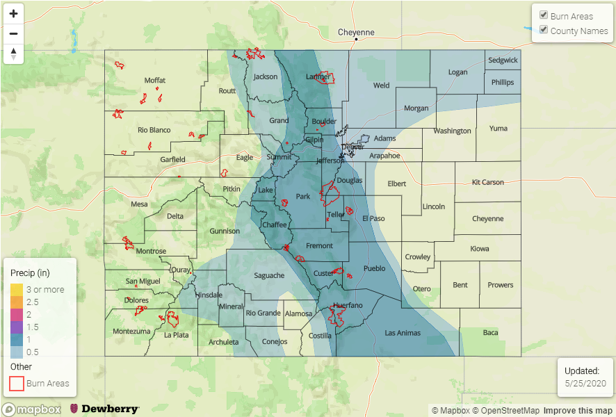
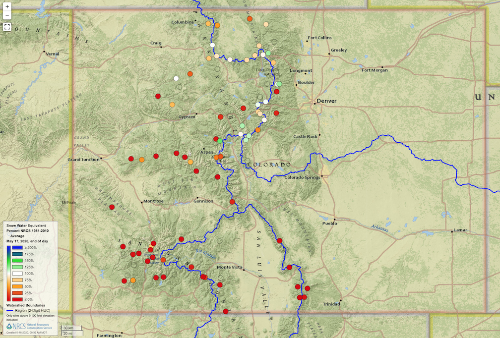
It looks like southern Colorado will reach complete melt out at gauged SNOTEL stations by tomorrow. Over northern Colorado, there could be another rise in water heights later this week with those hot, summer-like temperatures and increase rainfall chances. Not expecting any large-scale flooding, but low-lying areas and small creeks will likely be at bankfull conditions. Also, forecasts indicate the Yampa will be on the rise again with Elk River near Milner coming close to Action levels by next weekend.

Event #1: WednesdayThursday (5/27-5/28)

No Apparent Threat as moisture and dynamics return to the state with a passing shortwave.

A cold front looks to drop through the state behind a shortwave sometime on Wednesday night. Depending on timing, this could cause some heavy rainfall and severe weather for eastern Colorado with the main threats being strong winds and hail. However, good upper level dynamics remain to our north, so coverage is not expected to be widespread. As far as rainfall, right now, it’s looking like it is mostly a rainfall event for northeast Colorado and the Palmer Ridge; however, scattered storms will also be likely return to the Northwest Slope, Northern and Central Mountains as well. Overnight rainfall may linger over the plains. Storms should be moving fast enough during the afternoon hours that widespread flooding is not anticipated, thus the No Apparent flood threat.

Event #2: FridayMonday (5/296/1)

Elevated Threat as amplified ridge sets up over the state and allows Gulf of Mexico moisture to be advected northward.

This will be an interesting omega-like pattern for Event #2. Should the ridge axis set up nicely (slightly to our east) over a two-day period, rainfall could be widespread across the mountains – including southwestern Colorado. This would be very beneficial for the dry soils, worsening drought and early season melt out. Without much upper level dynamics in play, severe storms are not likely over the eastern plains, but the adjacent eastern plains could also see some decent rainfall with slower storm motions forecast. The Elevated Threat right now is mostly for recent burn areas, and details will likely change by Thursday’s FTO.

FTO 05-21-2020: High Fire Danger to Start Memorial Weekend before Storms Return Sunday

Issue Date: Thursday, May 21st, 2020
Issue Time: 12:30PM MDT
Valid Dates: 5/22 – 6/5

There will be two events for this FTO, and both will originate from the Low just off the coast of British Columbia/Washington. This Low is expected to slip southwards into the Great Basin Friday into Saturday. Initially, it will pull in a dry air mass and increase fire danger on Friday and Saturday. However, a cold front is expected to drop through Saturday night, which will help return moisture for widespread storm activity on Sunday into Monday. By late Monday into Tuesday, it should start to dry out with warmer temperatures forecast for mid-week when the ridge axis shifts east.

Long-range models are hinting at the mid-level energy from Event #1 hanging out somewhere over Texas and getting cut off from the main flow (Event #2). This would pull higher PW values northward on its east and north side (counter-clockwise motion) and return the chances for afternoon rain towards the end of the week. With a northwest flow likely returning aloft over the weekend, it may push another cold front south, which could interact with these higher PW values. Thus, the Elevated Threat for flooding during Event #2.

As anticipated and focused on in the last FTO, one of the main weather stories for this FTO is the critical fire weather forecast over Memorial Day weekend. The new drought map was released today which has increased the D3 area over the southern border, so it is dry! PW values at Grand Junction (and south) are in the 10th percentile for this time of year. Another SW to NE oriented jet streak will be over Colorado Friday/Saturday, which will increase surface winds into the 10-25 mph range with gusts 10 to 20 mph higher. Be sure to tune into your local NWS office for the latest and use caution with open flames while camping. There are already many counties with fire restrictions in place, so here is a map with those current restrictions. A Fire Weather Watch is already  in place for most of western and southern Colorado for tomorrow afternoon.

With that said, not much rainfall anticipated except for some scattered, high-based storms over the mountains on Friday and Saturday. Moisture increases behind the aforementioned cold front, but this looks mostly to be east of the Continental Divide. Storms should be mostly stratiform in nature Sunday into Monday, but if more convective storms can form on Sunday afternoon, we’ll have to watch the Spring Creek and Decker burn areas. At the tail end of the Denver PW plume is the increase in subtropical moisture mentioned for Event #2.

No change to the streamflow forecasts from the last couple of FTOs, but I just wanted to mention that the SWE from SNOTEL sites over the Upper Rio Grande Basin are showing complete melt out after this last hot stretch of temperatures. The San Miguel, Dolores, Animas and San Juan River Basins look like they will also melt out by early next week. This is very early (relative to climatology), which is typically in mid to end of June. Unless there is a major pattern shift over the next couple of months, we’ll be dealing with very high fire danger this summer due to the dry spring/end of winter.

Event #1: SundayMonday (5/24-5/25)

No Apparent Threat as moisture return from a cold front and surface low return widespread shower activity to the state.

Storm activity is expected to increase on Sunday with the main vorticity max moving into the state and a surface low forming over the Northeast Plains. Overall, there will be cooler temperatures with storms kicking off over the mountains by noon and activity spreading into the adjacent plains by mid-afternoon. The far eastern plains look to remain capped, so not expecting any severe weather at this time. A couple stronger storms could produce high enough rain rates (0.50 inches per hour) that would cause issues for recent burn areas over the Southeast Mountains, so we will be watching this closely. Storms may linger over the Southeast Mountains and immediate adjacent plains overnight, which would help increase totals. But that would be very welcomed with the lack of rainfall the last couple of months. Due to the anticipated stratiform nature of the storms, not thinking flooding is going to be an issue at this time, especially because it begins to dry out on Monday. Thus, there is No Apparent threat.

Event #2: Thursday – Sunday (5/28-5/31)

Elevated Threat as a “cut off low” pattern pulls subtropical moisture northward.

If the vorticity lobe is able to be cut off from the main flow as it passes through the state to start next week, it could create a nice surge of subtropical moisture northward into the state on its east and north side. Of course, this all depends on the strength, persistence and placement of that low. At this time, it’s a little too far out to know the details, but we should see an uptick in storms by the end of next week. Northwest flow will likely return to the state as the pattern begins to break up next weekend, which will likely drop a cold front southward. There will be an Elevated flood threat during that time if high moisture is intact over the state. Due to low confidence in the placement, strength and persistence of the low this far out, a map has not been drawn. Please tune back into the FTO on Monday as details will likely have evolved.

FTO 05-18-2020: Wildfire Risk & Building Drought Outweighs Flood Threat This Week

Issue Date: Monday, May 18th, 2020
Issue Time: 2PM MDT
Valid Dates: 5/19-6/2

The dominant weather story of this Outlook is will not be related to flooding, but instead focus on aridity and an elevated risk of wildfires. Before covering that, let us first begin by assessing the progress of the snow melt. As of last Friday, the statewide average snowpack, as measured by NRCS SNOTEL sites, stood at about 6 inches. This is down 64% from this year’s peak observed in early April and about 30% lower than normal for this time of year. However, as shown below, northern areas were closer to average than southern areas, which were significantly below normal and within a week or so of melting out completely. Overall, we do not expect any widespread snowmelt-related flooding for the rest of this spring and summer. However, locally, elevated flows could occur for smaller streams of northern Colorado, especially towards the Wyoming border.

Next, we switch topics to the current atmospheric circulation, as seen below in the water vapor imagery across the North Pacific Ocean and North America. An amplified upper-level steering pattern is seen with two large scale troughs over the central Pacific Ocean. The eastern feature will support precipitation Event #1, beginning on Wednesday and lasting through the early weekend.

From the perspective of dynamics, Event #1 may appear impressive with a well-defined trough advecting towards Colorado and a robust jet stream. However, it’s main limitation will be moisture, as shown in the forecasted Precipitable Water plumes below for Grand Junction and Denver. Note that PW remains well below average at Grand Junction during Event #1. Meanwhile, Denver and the eastern plains will see a brief surge in moisture into the 0.8-1.1 inch range, supporting multiple days of light to moderate precipitation and, more importantly, severe thunderstorms.

As today’s headline suggests, the more serious concern during this Outlook is the prolonged stretch of very dry and windy weather expected over southern CO, especially over the San Juan Mountains and San Luis Valley. As shown in the forecast dewpoint for Durango, below, we expect a 5-6 day stretch beginning today of very low humidity. Unfortunately, this region is already in a severe to extreme drought, implying that vegetation is abnormally dry and vulnerable to ignite and/or burn. This will set the stage for a significantly elevated risk of wildfires, especially Thursday-Sunday. Since this will coincide with Memorial Day weekend, we urge campers and hikers to stay alert to National Weather Service watches and warnings.


Event #1: Wednesday (5/20) through Saturday (5/23)

No Apparent Flood Threat as large-scale trough approaches Colorado

We expect diurnal shower and thunderstorm activity to pickup in coverage and intensity beginning Wednesday and persisting through Saturday. Although there will be some activity over the higher terrain east of the Continental Divide, limited moisture will cap rainfall to below 0.5 inches. Farther east, however, the combination of higher moisture, warm southerly flow and sufficient wind shear will lead to at least one day of elevated severe weather risk (Wednesday). It is possible that the severe weather threat will persist after Wednesday, but this is currently too uncertain given the previously noted dry air expected to enter from the southwest.

At this time, while light to moderate precipitation is likely, a flood threat is not foreseen due to marginal moisture and fast storm motion. However, a low end flood threat may emerge if enough moisture makes it into Colorado. This will be limited to the counties bordering Kansas and Nebraska. Stay tuned to daily Flood Threat Bulletin updates for more information.

Event #2: Thursday (5/28) to Friday (5/29)

No Apparent Flood Threat at this time, but moisture may return to eastern Colorado

Although there is agreement for a prolonged stretch of above normal temperatures following Event #1, there is significant disagreement among long range guidance from the GFS and ECMWF forecast systems regarding the return of moisture. At this time, it appears the best chance for enhanced precipitation chances will be in southeast Colorado in association with moisture return from the Gulf of Mexico. However, a precipitation map is not provided today, since it does not currently appear that rainfall will exceed 0.5 inches.

FTO 05-14-2020: Widespread Rainfall & Possible Severe Weather on Friday before the Drying Trend Begins

Issue Date: Thursday, May 14th, 2020
Issue Time: 2:45PM MDT
Valid Dates: 5/15 – 5/29

Quite the surge of moisture to our east that is marked in the water vapor imagery below (dashed green line). Unfortunately, this translates to less accumulation across the state the next couple of days. Event #1 starts tomorrow as the Low off the coast of CA pushes eastward. While most of the lift will be to our north, a nice vorticity max passes through the WSW flow tomorrow afternoon. There’s a slight pause before Event #2 begins as the closed Low pressure over the Pacific moves towards the California coast then dips slightly south. Before bringing rainfall back into the forecast on Tuesday, the system will increase southwest flow and advect a very dry air mass into the state from the Great Basin. Paired with a tightening surface gradient, critical and extreme fire weather will likely return to the forecast Monday and later next week. So be sure to tune into you local NWS office and the FTB Monday morning.

Another cold front will dip into the state tonight, which will help keep moisture around for another round of scattered, afternoon thunderstorms tomorrow. Coverage will likely look similar to today except a lee cycle will help increase the chances for severe weather over the Northeast Plains. With moisture remaining average to slightly above average this weekend, except afternoon storms to fire over the mountains and move into the adjacent plains favoring the Southern Front Range and Southeast Mountains for development. Each day, expect the coverage of storms to decrease due to the increasing SW flow starting to dry out the atmosphere. As the next Low pressure systems moves across the state (Event #2), except storms to briefly increase (Tuesday). Flow aloft is forecast to (quickly) turn southwest again, which starts the atmospheric drying trend and decreases storm chances. At this time, there is No Apparent threat for either event with PW remaining well below an inch. The one exception will be the far eastern plains tomorrow where southeast flow will pull in some higher moisture values, so tune in the FTB for the latest.

Not much change to the streamflow forecast from the last FTO. Streamflows over northern and central Colorado will start to increase on Monday before they start decreasing by the end of next week. Without any appreciable rainfall in the forecast over the next week and a half, it’s looking more and more like major spring flooding will be avoided. Snowpack summaries for the San Juan/Dolores, Gunnison and Rio Grande basins look like they will be melted out in the next week or two (not pictured). I was able to find a nice image of Colorado Reservoir Storage below, which I discussed in the FTO on Monday. It is always interesting to watch the usage each month, and I’m happy to report the state is starting the summer in pretty good shape.

Event #1: Friday – Sunday (5/15-5/17)

No Apparent Threat as a lee cyclone increases severe weather chances for the Northeast Plains on Friday.

Storms will have the greatest coverage on Friday with decreasing coverage Saturday into Sunday. Thinking most of the scattered storms on Saturday and Sunday will be confined to the eastern mountains and immediate adjacent plains. For tomorrow, the main threat with the severe storms tomorrow will be damaging winds and large hail as a MCS looks to form in the evening hours. Afternoon and early evening storms should be moving pretty quickly, so not thinking there is a flood threat at this time. Lingering overnight storms may cause some flooding issues if rain falls over the same area tonight. However, it is pretty dry out east and with the green up, not much more than nuisance lowland flooding is likely. We’ll also have to wait and take a look at moisture behind the front tomorrow. If dew points remain high (50F+) along the immediate adjacent plains, there may also need to be Low flood threat issued for the Urban Corridor. However, it is more likely that this moisture will mix out at the surface similar to today.

Event #2: Tuesday (5/19)

No Apparent Threat as the next system moves into the state and briefly elevates moisture.

Although the next system looks to be rather strong, its location won’t be favorable for pulling high moisture northwards into the state at this time. There will be a brief increase in low-level moisture on Tuesday as the system pushes east, so some scattered storms are likely. However, the majority of the time this system will be affecting the state, it will be pulling in dry air from the southwest and increasing surface winds. Thus, this system has more of a critical fire weather component than flood threat. Expect some summer like temperatures as the ridge builds overhead.