Issue Date: Thursday, May 21st, 2020
Issue Time: 12:30PM MDT
Valid Dates: 5/22 – 6/5
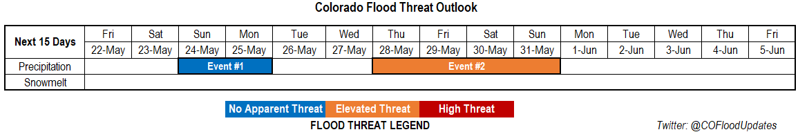
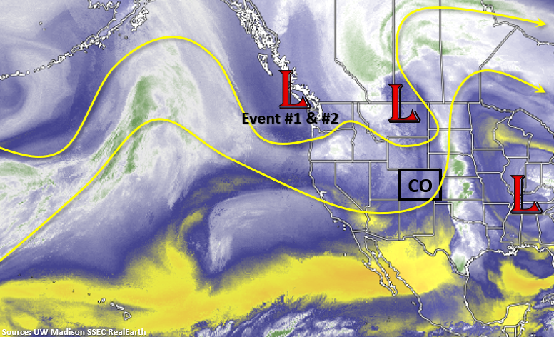
There will be two events for this FTO, and both will originate from the Low just off the coast of British Columbia/Washington. This Low is expected to slip southwards into the Great Basin Friday into Saturday. Initially, it will pull in a dry air mass and increase fire danger on Friday and Saturday. However, a cold front is expected to drop through Saturday night, which will help return moisture for widespread storm activity on Sunday into Monday. By late Monday into Tuesday, it should start to dry out with warmer temperatures forecast for mid-week when the ridge axis shifts east.
Long-range models are hinting at the mid-level energy from Event #1 hanging out somewhere over Texas and getting cut off from the main flow (Event #2). This would pull higher PW values northward on its east and north side (counter-clockwise motion) and return the chances for afternoon rain towards the end of the week. With a northwest flow likely returning aloft over the weekend, it may push another cold front south, which could interact with these higher PW values. Thus, the Elevated Threat for flooding during Event #2.
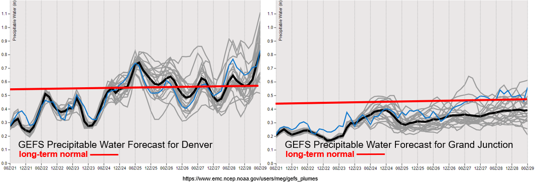
As anticipated and focused on in the last FTO, one of the main weather stories for this FTO is the critical fire weather forecast over Memorial Day weekend. The new drought map was released today which has increased the D3 area over the southern border, so it is dry! PW values at Grand Junction (and south) are in the 10th percentile for this time of year. Another SW to NE oriented jet streak will be over Colorado Friday/Saturday, which will increase surface winds into the 10-25 mph range with gusts 10 to 20 mph higher. Be sure to tune into your local NWS office for the latest and use caution with open flames while camping. There are already many counties with fire restrictions in place, so here is a map with those current restrictions. A Fire Weather Watch is already in place for most of western and southern Colorado for tomorrow afternoon.
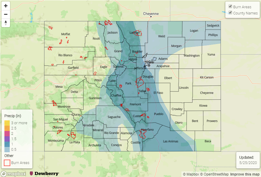
With that said, not much rainfall anticipated except for some scattered, high-based storms over the mountains on Friday and Saturday. Moisture increases behind the aforementioned cold front, but this looks mostly to be east of the Continental Divide. Storms should be mostly stratiform in nature Sunday into Monday, but if more convective storms can form on Sunday afternoon, we’ll have to watch the Spring Creek and Decker burn areas. At the tail end of the Denver PW plume is the increase in subtropical moisture mentioned for Event #2.
No change to the streamflow forecasts from the last couple of FTOs, but I just wanted to mention that the SWE from SNOTEL sites over the Upper Rio Grande Basin are showing complete melt out after this last hot stretch of temperatures. The San Miguel, Dolores, Animas and San Juan River Basins look like they will also melt out by early next week. This is very early (relative to climatology), which is typically in mid to end of June. Unless there is a major pattern shift over the next couple of months, we’ll be dealing with very high fire danger this summer due to the dry spring/end of winter.
Event #1: Sunday – Monday (5/24-5/25)
No Apparent Threat as moisture return from a cold front and surface low return widespread shower activity to the state.
Storm activity is expected to increase on Sunday with the main vorticity max moving into the state and a surface low forming over the Northeast Plains. Overall, there will be cooler temperatures with storms kicking off over the mountains by noon and activity spreading into the adjacent plains by mid-afternoon. The far eastern plains look to remain capped, so not expecting any severe weather at this time. A couple stronger storms could produce high enough rain rates (0.50 inches per hour) that would cause issues for recent burn areas over the Southeast Mountains, so we will be watching this closely. Storms may linger over the Southeast Mountains and immediate adjacent plains overnight, which would help increase totals. But that would be very welcomed with the lack of rainfall the last couple of months. Due to the anticipated stratiform nature of the storms, not thinking flooding is going to be an issue at this time, especially because it begins to dry out on Monday. Thus, there is No Apparent threat.
Event #2: Thursday – Sunday (5/28-5/31)
Elevated Threat as a “cut off low” pattern pulls subtropical moisture northward.
If the vorticity lobe is able to be cut off from the main flow as it passes through the state to start next week, it could create a nice surge of subtropical moisture northward into the state on its east and north side. Of course, this all depends on the strength, persistence and placement of that low. At this time, it’s a little too far out to know the details, but we should see an uptick in storms by the end of next week. Northwest flow will likely return to the state as the pattern begins to break up next weekend, which will likely drop a cold front southward. There will be an Elevated flood threat during that time if high moisture is intact over the state. Due to low confidence in the placement, strength and persistence of the low this far out, a map has not been drawn. Please tune back into the FTO on Monday as details will likely have evolved.