Issue Date: Thursday, May 14th, 2020
Issue Time: 2:45PM MDT
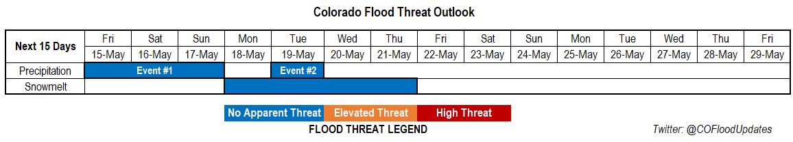
Valid Dates: 5/15 – 5/29
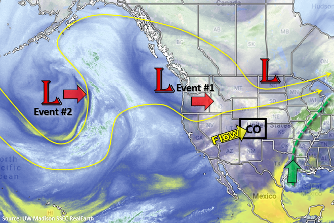
Quite the surge of moisture to our east that is marked in the water vapor imagery below (dashed green line). Unfortunately, this translates to less accumulation across the state the next couple of days. Event #1 starts tomorrow as the Low off the coast of CA pushes eastward. While most of the lift will be to our north, a nice vorticity max passes through the WSW flow tomorrow afternoon. There’s a slight pause before Event #2 begins as the closed Low pressure over the Pacific moves towards the California coast then dips slightly south. Before bringing rainfall back into the forecast on Tuesday, the system will increase southwest flow and advect a very dry air mass into the state from the Great Basin. Paired with a tightening surface gradient, critical and extreme fire weather will likely return to the forecast Monday and later next week. So be sure to tune into you local NWS office and the FTB Monday morning.
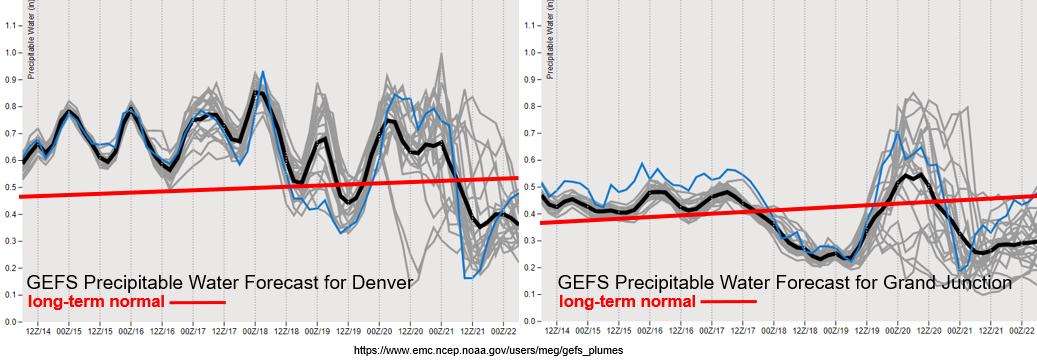
Another cold front will dip into the state tonight, which will help keep moisture around for another round of scattered, afternoon thunderstorms tomorrow. Coverage will likely look similar to today except a lee cycle will help increase the chances for severe weather over the Northeast Plains. With moisture remaining average to slightly above average this weekend, except afternoon storms to fire over the mountains and move into the adjacent plains favoring the Southern Front Range and Southeast Mountains for development. Each day, expect the coverage of storms to decrease due to the increasing SW flow starting to dry out the atmosphere. As the next Low pressure systems moves across the state (Event #2), except storms to briefly increase (Tuesday). Flow aloft is forecast to (quickly) turn southwest again, which starts the atmospheric drying trend and decreases storm chances. At this time, there is No Apparent threat for either event with PW remaining well below an inch. The one exception will be the far eastern plains tomorrow where southeast flow will pull in some higher moisture values, so tune in the FTB for the latest.
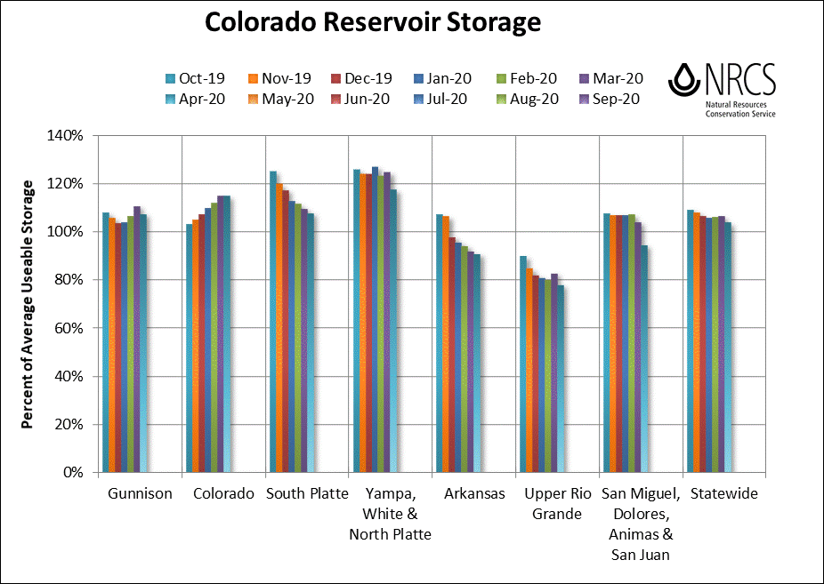
Not much change to the streamflow forecast from the last FTO. Streamflows over northern and central Colorado will start to increase on Monday before they start decreasing by the end of next week. Without any appreciable rainfall in the forecast over the next week and a half, it’s looking more and more like major spring flooding will be avoided. Snowpack summaries for the San Juan/Dolores, Gunnison and Rio Grande basins look like they will be melted out in the next week or two (not pictured). I was able to find a nice image of Colorado Reservoir Storage below, which I discussed in the FTO on Monday. It is always interesting to watch the usage each month, and I’m happy to report the state is starting the summer in pretty good shape.
Event #1: Friday – Sunday (5/15-5/17)
No Apparent Threat as a lee cyclone increases severe weather chances for the Northeast Plains on Friday.
Storms will have the greatest coverage on Friday with decreasing coverage Saturday into Sunday. Thinking most of the scattered storms on Saturday and Sunday will be confined to the eastern mountains and immediate adjacent plains. For tomorrow, the main threat with the severe storms tomorrow will be damaging winds and large hail as a MCS looks to form in the evening hours. Afternoon and early evening storms should be moving pretty quickly, so not thinking there is a flood threat at this time. Lingering overnight storms may cause some flooding issues if rain falls over the same area tonight. However, it is pretty dry out east and with the green up, not much more than nuisance lowland flooding is likely. We’ll also have to wait and take a look at moisture behind the front tomorrow. If dew points remain high (50F+) along the immediate adjacent plains, there may also need to be Low flood threat issued for the Urban Corridor. However, it is more likely that this moisture will mix out at the surface similar to today.
Event #2: Tuesday (5/19)
No Apparent Threat as the next system moves into the state and briefly elevates moisture.
Although the next system looks to be rather strong, its location won’t be favorable for pulling high moisture northwards into the state at this time. There will be a brief increase in low-level moisture on Tuesday as the system pushes east, so some scattered storms are likely. However, the majority of the time this system will be affecting the state, it will be pulling in dry air from the southwest and increasing surface winds. Thus, this system has more of a critical fire weather component than flood threat. Expect some summer like temperatures as the ridge builds overhead.