Issue Date: Monday, May 18th, 2020
Issue Time: 2PM MDT
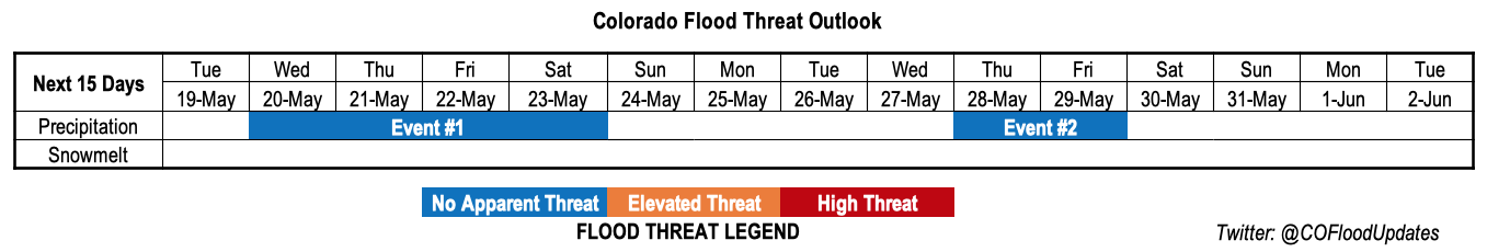
Valid Dates: 5/19-6/2
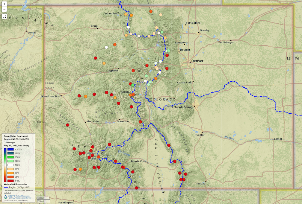
The dominant weather story of this Outlook is will not be related to flooding, but instead focus on aridity and an elevated risk of wildfires. Before covering that, let us first begin by assessing the progress of the snow melt. As of last Friday, the statewide average snowpack, as measured by NRCS SNOTEL sites, stood at about 6 inches. This is down 64% from this year’s peak observed in early April and about 30% lower than normal for this time of year. However, as shown below, northern areas were closer to average than southern areas, which were significantly below normal and within a week or so of melting out completely. Overall, we do not expect any widespread snowmelt-related flooding for the rest of this spring and summer. However, locally, elevated flows could occur for smaller streams of northern Colorado, especially towards the Wyoming border.
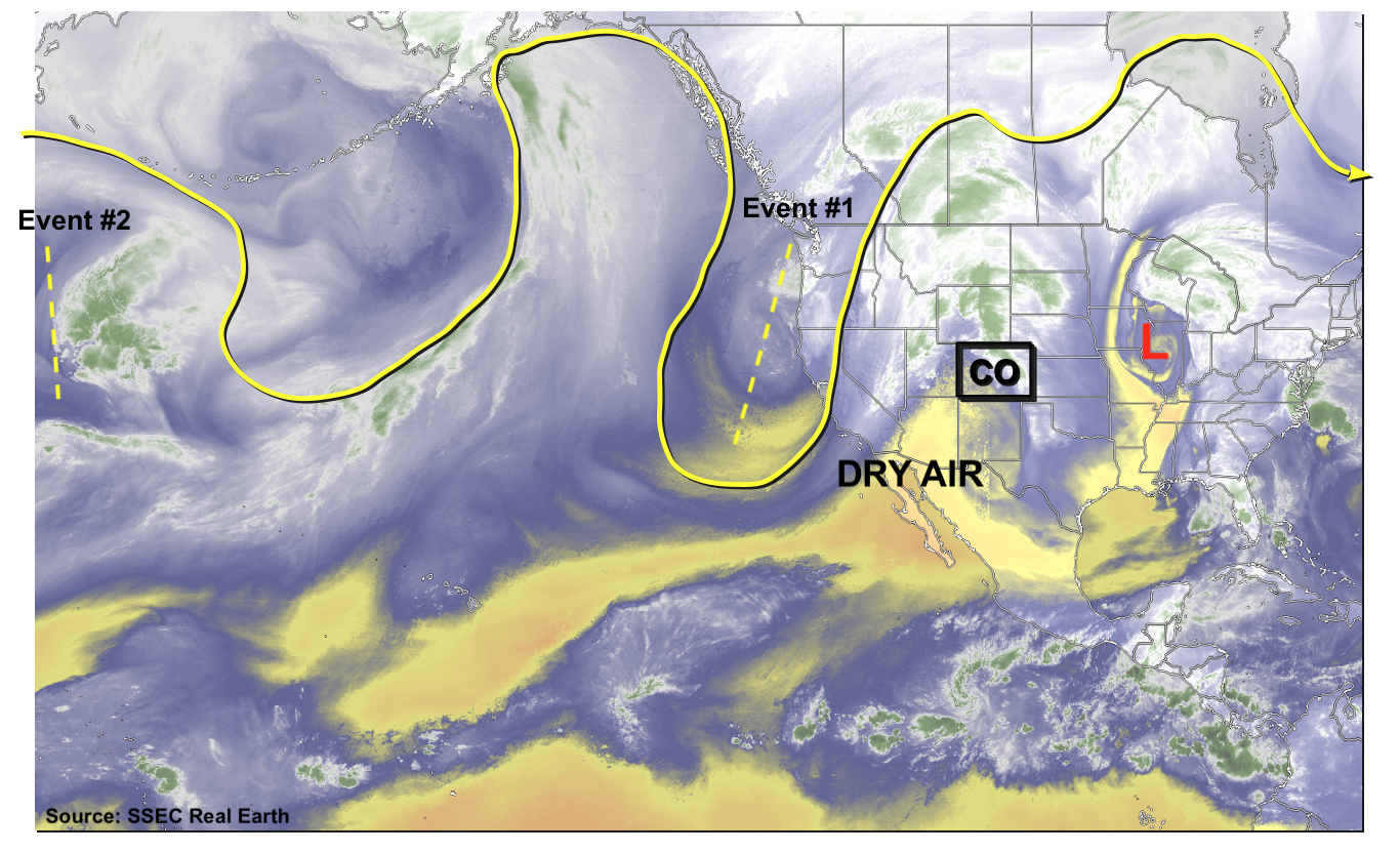
Next, we switch topics to the current atmospheric circulation, as seen below in the water vapor imagery across the North Pacific Ocean and North America. An amplified upper-level steering pattern is seen with two large scale troughs over the central Pacific Ocean. The eastern feature will support precipitation Event #1, beginning on Wednesday and lasting through the early weekend.
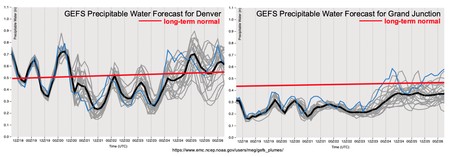
From the perspective of dynamics, Event #1 may appear impressive with a well-defined trough advecting towards Colorado and a robust jet stream. However, it’s main limitation will be moisture, as shown in the forecasted Precipitable Water plumes below for Grand Junction and Denver. Note that PW remains well below average at Grand Junction during Event #1. Meanwhile, Denver and the eastern plains will see a brief surge in moisture into the 0.8-1.1 inch range, supporting multiple days of light to moderate precipitation and, more importantly, severe thunderstorms.
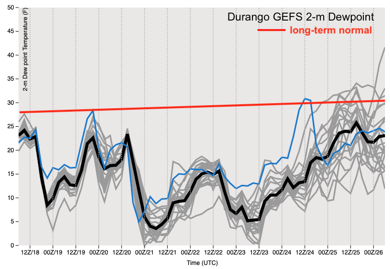
As today’s headline suggests, the more serious concern during this Outlook is the prolonged stretch of very dry and windy weather expected over southern CO, especially over the San Juan Mountains and San Luis Valley. As shown in the forecast dewpoint for Durango, below, we expect a 5-6 day stretch beginning today of very low humidity. Unfortunately, this region is already in a severe to extreme drought, implying that vegetation is abnormally dry and vulnerable to ignite and/or burn. This will set the stage for a significantly elevated risk of wildfires, especially Thursday-Sunday. Since this will coincide with Memorial Day weekend, we urge campers and hikers to stay alert to National Weather Service watches and warnings.
Event #1: Wednesday (5/20) through Saturday (5/23)
No Apparent Flood Threat as large-scale trough approaches Colorado
We expect diurnal shower and thunderstorm activity to pickup in coverage and intensity beginning Wednesday and persisting through Saturday. Although there will be some activity over the higher terrain east of the Continental Divide, limited moisture will cap rainfall to below 0.5 inches. Farther east, however, the combination of higher moisture, warm southerly flow and sufficient wind shear will lead to at least one day of elevated severe weather risk (Wednesday). It is possible that the severe weather threat will persist after Wednesday, but this is currently too uncertain given the previously noted dry air expected to enter from the southwest.
At this time, while light to moderate precipitation is likely, a flood threat is not foreseen due to marginal moisture and fast storm motion. However, a low end flood threat may emerge if enough moisture makes it into Colorado. This will be limited to the counties bordering Kansas and Nebraska. Stay tuned to daily Flood Threat Bulletin updates for more information.
Event #2: Thursday (5/28) to Friday (5/29)
No Apparent Flood Threat at this time, but moisture may return to eastern Colorado
Although there is agreement for a prolonged stretch of above normal temperatures following Event #1, there is significant disagreement among long range guidance from the GFS and ECMWF forecast systems regarding the return of moisture. At this time, it appears the best chance for enhanced precipitation chances will be in southeast Colorado in association with moisture return from the Gulf of Mexico. However, a precipitation map is not provided today, since it does not currently appear that rainfall will exceed 0.5 inches.