FTO 06-22-2020: Stormy Weather Pattern to Start Summer before Fire Danger Returns Next Week

Issue Date: Monday, June 22nd, 2020
Issue Time: 2:15PM MDT
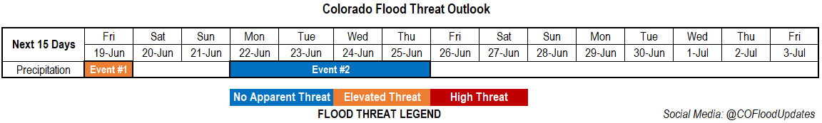
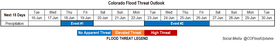
Valid Dates: 6/23 – 7/7

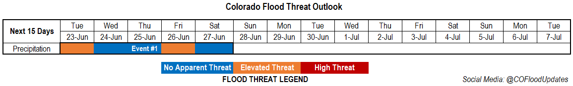
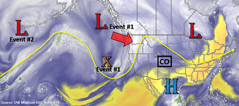
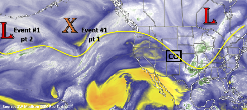
Event #1 begins tomorrow with an Elevated flood threat issued. Moisture looks to increase somewhat under the ridge as the axis slides slightly to the east. Additionally, without any upper level jet over the state, storms should become more stationary. This will help to increase totals over eastern Colorado, and slow moving storms could be dangerous if they form over the Spring Creek or Decker burn area. To the west, more of the same (dry conditions) with only isolated high storms forecast along the Continental Divide.

There’s a lull in the flood threat on Wednesday and Thursday, but a shortwave will likely combine with increased moisture on Friday afternoon. This should help return rainfall to portions of western Colorado as well. With more westerly flow forecast aloft as the shortwave passes overhead, some heavier rainfall may be possible as storms make their way to the eastern plains. Thus, the Elevated flood threat. Residual moisture will likely produce afternoon storms over the northern high terrains on Saturday, before it begins to dry out behind the trough.

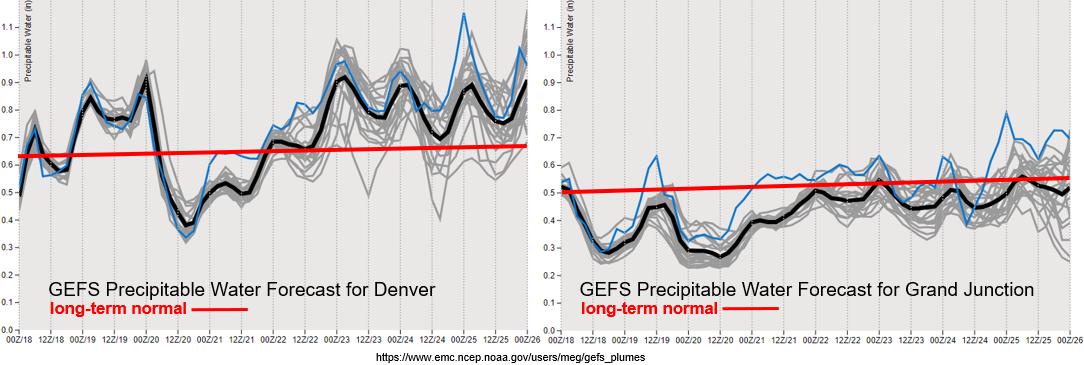
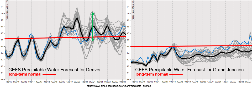
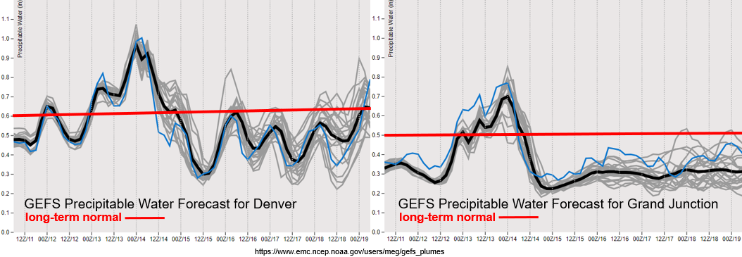
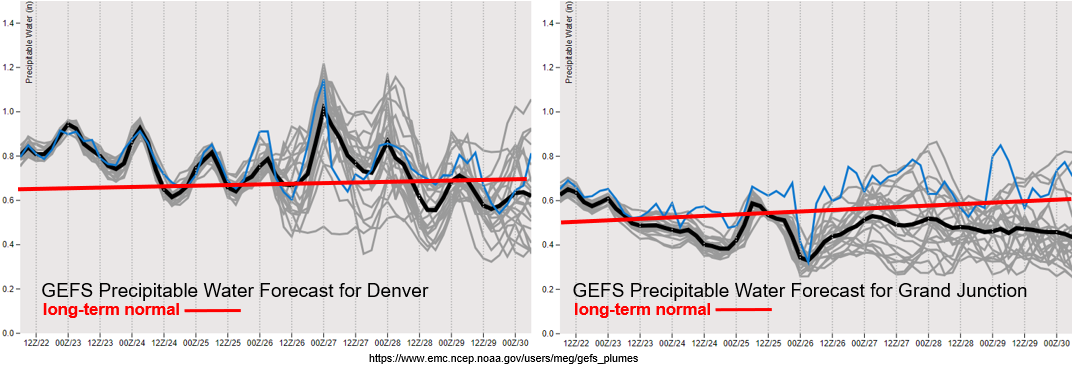
Note that the y-axis has been increased to 1.5 inches in the PW plumes below. There is good consensus that PW will remain at or above 1 inch over Denver tomorrow, and with slower steering flows this will mean a chance for higher rain rates and rainfall totals. Since 1 inch is a good proxy for heavy rainfall, the Elevated flood threat has been issued – although mostly for the burn areas. PW looks to decrease today to around climatology average over western Colorado. The GEFS is showing quite a bit of uncertainty in regards to moisture later this week across the state, but there looks to be an upwards trend over eastern Colorado. It is likely by Friday that moisture over western Colorado will increase across the northern high terrains with the passing shortwave, so PM storms could possibly return to the forecast.

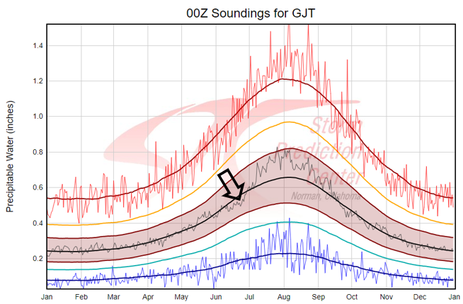
I always like to point out the strong upward trend in PW over western Colorado that begins around the summer solstice each year (bottom image). You see the same increase over eastern Colorado as monsoon season arrives, but the slope of the line isn’t quite as steep. Despite PW values increasing in climo during this time of year, the weather pattern looks to dry out early next week and pair with an increase in southwesterly surface winds. So be on the lookout for critical fire weather to return to the state anytime from Sunday to Tuesday.

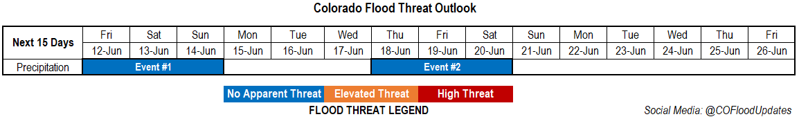
Event #1: Tuesday (6/23) – Saturday (6/27)

Elevated Threat/No Apparent Threat as ridging and shortwaves combine with on and off low-level moisture over the state.

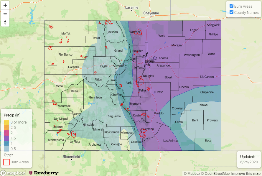
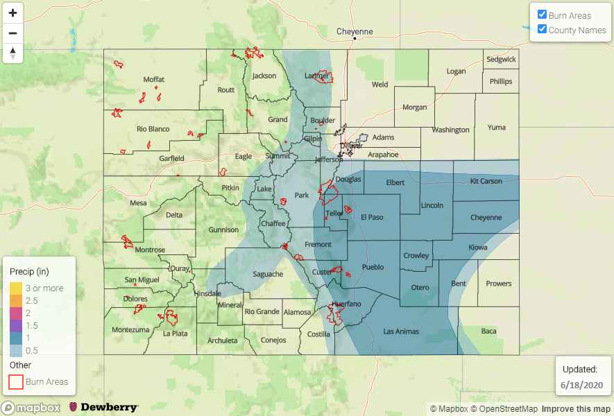
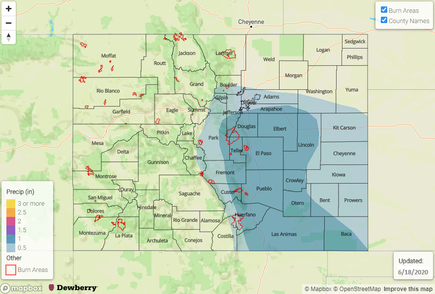
Not a lot of upper air support during this period, which means there is a low chance for severe storms. The best chance for a severe storm or two will be on Friday or Saturday as shear looks to increase over the eastern plains. By how much is the real question as the GEFS is still having a hard time pinning down the next system’s details. The precipitation prediction below has quite a few days of rainfall in it, and also expect the totals to be more patchy in coverage than widespread. The isohyets also assume the storms will make it into the eastern plains (higher moisture) on Friday with an increase in westerly flow as the shortwave passes overhead (at peak heating). So, a lot of ingredients still need to come together, and it’s hard to know get the details correct more than a couple days in advance. The Palmer Ridge, Front Range, Wet Mountains and southern Raton Ridge are specifically included in the 1.50 inch ring due to these regions precipitation climo/pattern in June.

FTO 06-18-2020: Heavy Rainfall Possible for Southeast Colorado on Friday

Issue Date: Thursday, June 18th, 2020
Issue Time: 2:30PM MDT
Valid Dates: 6/19 – 7/3

The main axis of the trough will move through Colorado on Friday, which will return afternoon and evening storms to eastern Colorado (Event #1). With upper level dynamics in place, a couple severe thunderstorms will be possible over the Southeast Plains with the main threats being severe hail and wind. Westerly flow aloft behind the trough quickly dries out the lower levels heading this weekend, so expect a downtick in storm activity. Monday, Event #2 begins as another cold front slides south during the late afternoon/evening and returns low-level moisture. Rainfall is possible both along and behind the front this time with storm activity increasing on Tuesday in a post-frontal upslope flow environment. Wednesday and Thursday, another ridge begins to build overhead. A developing High over the southwest US will help reinforce this moisture under the ridge and may pull a little subtropical moisture northward into the state. As the trough passes to the north (Event #2 Low), increased mid-level lift is also anticipated. This will help to keep afternoon storms in the forecast through the end of the week. Storms will likely stay in the forecast through next weekend, but it’s a little far out to add anything to this heavy rainfall outlook.

The PW images below are from last night’s run, so use caution when looking at the timeline. Behind the front, PW values start to increase (today), but the moisture is quickly scoured out over western Colorado. Winds are also forecast to pick up over southwest Colorado tomorrow afternoon as the trough moves through, so paired with the dry atmosphere, critical fire weather is likely. Moisture looks to remain a little higher throughout next week and with no strong systems moving through, more relaxed surface winds are anticipated. This should bring a break in critical fire weather.

Over eastern Colorado, PW is expected to either stay the same or slightly increase tomorrow, which will help produce another round storms. Instability looks to be a little greater as well, which should help create a couple severe thunderstorms over the Southeast Plains. PW values in this area are forecast near an inch (not shown), so heavy rainfall is likely as the storms move off the eastern mountains into the I-25 corridor with the westerly steering flow. Thus, there is an Elevated flood threat issued.

Event #1: Friday (6/19)

Elevated Threat as moisture increases over the Southeast Plains.

Storms are expected to return to the eastern mountains on Friday with upslope flow initiating the convection. With mid-level energy also present, storm are expected to be a little more widespread and intense than today. Rainfall will likely develop over the Front Range and northern Southeast Mountains by noon, and stronger thunderstorms will develop where the sun can break through. As storms move off the mountains with the more westerly steering flow, they will likely increase in intensity due to higher instability and more moisture. Further south, (south of the Palmer Ridge) heavy rainfall will be possible with the stronger storms that develop, and max 1-hour rain rates just over 1 inch will be possible. Also forecasting increased totals along the Raton Ridge with the increased convergence over the area. Recent burn areas over the Southeast Mountains will also be under the gun for the heavy rainfall threat, and the highest threat will likely be over the Decker burn area.

Event #2: MondayThursday (6/22 – 6/25)

No Apparent Threat as moisture returns behind another cold front and gets trapped under the building ridge.

Moving up this next event from Monday’s FTO. Rain looks to return to the forecast by Monday afternoon/evening behind and along another cold front. Low-level moisture is increased for post-frontal upslope flow on Tuesday. It doesn’t look to have too big of a heavy rainfall threat yet, but if the jet stays to the north east of Colorado, steering flows will decrease and allow storms to drop more rainfall. Details like this will continue to be watched over the weekend. Wednesday and Thursday, storms will likely form over the higher terrains each afternoon with residual moisture under the ridge. The reformation of the subtropical high might also help reinforce low-level moisture over eastern Colorado. It looks to stay stormy heading into next weekend, but more on that in Monday’s FTO.

FTO 06-15-2020: Cold Front on Wednesday Will Bring Some Relief from the Heat and Storms Back into the Forecast

Issue Date: Monday, June 15th, 2020
Issue Time: 2:15PM MDT
Valid Dates: 6/16 – 6/30

The quick moving low pressure systems will continue to rotate through the state, which will impact the weather a couple of days at a time. That first system will arrive tomorrow as the Low moves into the Great Basin. This will position another jet streak over western Colorado, which will increase the dry, southwest flow. The main threat from this system will high fire danger across the state as there will be little moisture available for storms to develop. That same system then intensifies to our north on Wednesday, and it drops a cold front through the state – first west (Wednesday afternoon) and then east (Wednesday night). It will help cool things off by ~10F on Thursday, and it should return moisture for storms over the eastern mountains and eastern plains on Thursday and Friday. Heading into the weekend, there is a possibility that enough moisture hangs around for scattered afternoon storms to fire over the mountains, but the more likely scenario will be a drop off in storm activity.

It’s a bit hard to nail down the details of Event #2, but unsettled weather will likely return by mid-next week. Moisture for storms will likely be from a combination of frontal passages, mid-level energy, and subtropical moisture as the 500mb high begins to build over the four corners region by the week’s end. At this time there is No Apparent flood threat issued.

Taking a look at the PW plume for Grand Junction (right), it is going to be very dry tomorrow. With 10-meter surface winds forecast in the 20 to 25 mph range over the Northwest Slope and Grand Valley, critical fire weather will continue and intensify. Surface winds further south look a little less powerful (Southwest Slope and San Luis Valley), so more spotty fire weather conditions are likely over these regions. You also see that slight uptick in moisture behind the cold front on Wednesday. This likely won’t be enough to trigger afternoon convection in the mountains along and behind the front, although an increase in cloud cover should be expected along with some gusty northerly winds.

The moisture return is a much stronger signal over eastern Colorado as values increase from 0.3 inches to just below an inch. Thus, the forecast for an increase in afternoon thunderstorm activity with a peak in rainfall coverage and intensity on Friday afternoon. The runs then show quite the spread in PW (green arrow), but the downward trend will translate to a decrease in storm activity for Saturday and Sunday. So, there is some uncertainty in the storm forecast for this weekend.

Event #1: ThursdayFriday (6/18 – 6/19)

No Apparent Threat as low-level moisture returns for afternoon rainfall behind a cold front.

Storms are expected to return to the eastern mountains on Thursday. Steering flow should be fairly weak, so storms will likely only occur over the eastern mountains favoring the Front Range. However, some rainfall could spill into the immediate adjacent plains with the southwest steering flow. Better moisture and some mid-level vorticity will combine on Friday, which is expected to bring the thunderstorm threat into the eastern plains. Steering flow changes from the northeast as a shortwave passes overhead, and this could help trigger a couple severe thunderstorms over the eastern plains along a dry line. At this time there is No Apparent threat as storms will likely be moving quickly. Please tune into the FTO on Thursday as local heavy rainfall may be possible if PW values are closer to that 1 inch mark.

Event #2: TuesdayFriday (6/23 – 6/26)

No Apparent Threat as moisture returns to the state in a series of fronts, passages of mid-level energy, and a weak subtropical moisture surge.

Again, I don’t like to give events this far out too much detail as they will inevitably change. Things look to get stormy again by mid-next week. The next system looks to push a cold front through the eastern plains either Tuesday or Wednesday. That will bring some relief from the heat as it is expected to be unseasonably hot over the weekend again.  Thursday into Friday, the GFS is finally hinting at the 500mb high developing over the southwest. This would help pull up subtropical moisture into the state for afternoon, diurnally driven storms. Not seeing the giant PW surges quite yet, but slow steering winds combining with moisture under this ridge is worth mentioning in the FTO. No map has been drawn due to the low confidence in details.

FTO 06-11-2020: Storms Quickly Return on Saturday Before the Next Dry Period

Issue Date: Thursday, June 11th, 2020
Issue Time: 1:30PM MDT
Valid Dates: 6/12 – 6/26

Two events are identified for this FTO, with Event #1 beginning tomorrow. Over the last couple of days, a ridge has been building over the Great Basin to our west. This has returned sunshine, warmer temperatures, and a quieter weather pattern after a stormy start to the week. The vorticity maximum (orange “X”) and Low will combine over the Pacific Northwest on Saturday (Event #1) and start to move to the northeast through this weekend. By Sunday/Monday the second Low pressure system slides into the Gulf of Alaska from the west, which will place Colorado under weak, dry southwesterly flow to start the work week. Expecting hot temperatures to return for Event #1 despite the increase in storminess.

It then becomes a bit unclear as to what will happen with models varying from one another and run to run. However, there will likely be an increased chance for rainfall sometime at the end of next week (Thursday to Saturday time frame) as the next system moves inland, becomes an open wave, and releases its mid-level energy (Event #2). There does not look to be a lot of moisture associated with this system, as of now, so there is No Apparent Flood threat issued.

Taking a look at the PW plumes below, there’s a nice northward surge of moisture as the ridge is displaced eastward for Event #1 both east and west of Colorado. PW reaches around 1 inch over Denver and up to 0.70 inches over western Colorado. While rain is expected to return to the southern high terrains on Friday, the intensity and coverage of precipitation will peak for Event #1 on Saturday over the high terrains and Urban Corridor/Palmer Ridge.

PW rapidly drops off on Sunday west of the Divide, and the GEFS is also showing southwest surface winds increasing during this period. This means that there may be some fire weather concerns for the western slope on Sunday afternoon. Next week, the jet stream looks to remain mostly northwest of the state, but it may dip into the northwest corner. Thus, there may be some critical fire weather for that region with PW dropping below 0.30 inches.

Lastly, the D3 drought area has been expanded to cover almost all of southern Colorado, while up north remains drought free. Despite receiving rainfall over the Southeast Plains on Tuesday, it was not nearly enough to make any impact. Looking forward to that monsoon moisture shift as I’m sure these areas are getting quite crispy.

Event #1: Friday – Sunday (6/12 – 6/14)

No Apparent Threat as next trough moves into the Pacific Northwest and moves to the northeast.

As mentioned above, storms are first expected to increase across the southern high terrains on Friday. By Saturday, better moisture and upper dynamics will be in place, so there will likely be an increase in afternoon storms intensity and coverage over the high terrains. The southwest flow should keep the storms moving, so at this time there is No Apparent flood threat. Some small hail and gusty winds may be possible with CAPE values around 1000 J/kg over western Colorado. Storms that form over the Front Range will likely spill into the adjacent plains (Urban Corridor and Palmer Ridge) with the southwest steering flow, but likely won’t survive into the far eastern plains with storm motion. As quickly as the moisture returns, it is expected to mix out. Thus, there will be a large downtick in afternoon storm activity by Sunday.

Event #2: Thursday Saturday (6/18 – 6/20)

No Apparent Threat as next trough passes north of Colorado, but there is low confidence in this events’ details.

Don’t want to give this event too much time as the models and runs are all showing drastically different patterns by the end of the week. Some models are producing little to no precipitation, while others are showing more widespread storminess with all models indicating different timing. Right now, not thinking that there will be a large moisture return for the event, and of three days mentioned, likely only one will have meaningful precipitation. A map has not be drawn for these reasons and that precipitation could easily remain under 0.50 inches. We will keep an eye on this for the next couple FTOs, and confidence in the forecast will likely increase towards the end of next week.