Issue Date: Monday, June 15th, 2020
Issue Time: 2:15PM MDT
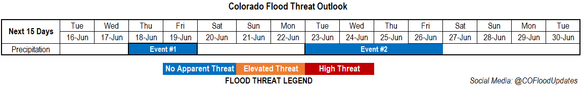
Valid Dates: 6/16 – 6/30
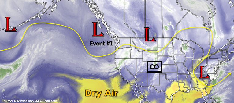
The quick moving low pressure systems will continue to rotate through the state, which will impact the weather a couple of days at a time. That first system will arrive tomorrow as the Low moves into the Great Basin. This will position another jet streak over western Colorado, which will increase the dry, southwest flow. The main threat from this system will high fire danger across the state as there will be little moisture available for storms to develop. That same system then intensifies to our north on Wednesday, and it drops a cold front through the state – first west (Wednesday afternoon) and then east (Wednesday night). It will help cool things off by ~10F on Thursday, and it should return moisture for storms over the eastern mountains and eastern plains on Thursday and Friday. Heading into the weekend, there is a possibility that enough moisture hangs around for scattered afternoon storms to fire over the mountains, but the more likely scenario will be a drop off in storm activity.
It’s a bit hard to nail down the details of Event #2, but unsettled weather will likely return by mid-next week. Moisture for storms will likely be from a combination of frontal passages, mid-level energy, and subtropical moisture as the 500mb high begins to build over the four corners region by the week’s end. At this time there is No Apparent flood threat issued.
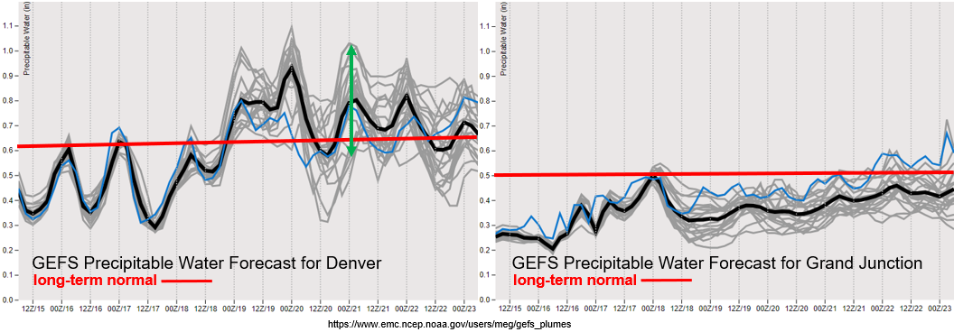
Taking a look at the PW plume for Grand Junction (right), it is going to be very dry tomorrow. With 10-meter surface winds forecast in the 20 to 25 mph range over the Northwest Slope and Grand Valley, critical fire weather will continue and intensify. Surface winds further south look a little less powerful (Southwest Slope and San Luis Valley), so more spotty fire weather conditions are likely over these regions. You also see that slight uptick in moisture behind the cold front on Wednesday. This likely won’t be enough to trigger afternoon convection in the mountains along and behind the front, although an increase in cloud cover should be expected along with some gusty northerly winds.
The moisture return is a much stronger signal over eastern Colorado as values increase from 0.3 inches to just below an inch. Thus, the forecast for an increase in afternoon thunderstorm activity with a peak in rainfall coverage and intensity on Friday afternoon. The runs then show quite the spread in PW (green arrow), but the downward trend will translate to a decrease in storm activity for Saturday and Sunday. So, there is some uncertainty in the storm forecast for this weekend.
Event #1: Thursday – Friday (6/18 – 6/19)
No Apparent Threat as low-level moisture returns for afternoon rainfall behind a cold front.
Storms are expected to return to the eastern mountains on Thursday. Steering flow should be fairly weak, so storms will likely only occur over the eastern mountains favoring the Front Range. However, some rainfall could spill into the immediate adjacent plains with the southwest steering flow. Better moisture and some mid-level vorticity will combine on Friday, which is expected to bring the thunderstorm threat into the eastern plains. Steering flow changes from the northeast as a shortwave passes overhead, and this could help trigger a couple severe thunderstorms over the eastern plains along a dry line. At this time there is No Apparent threat as storms will likely be moving quickly. Please tune into the FTO on Thursday as local heavy rainfall may be possible if PW values are closer to that 1 inch mark.
Event #2: Tuesday – Friday (6/23 – 6/26)
No Apparent Threat as moisture returns to the state in a series of fronts, passages of mid-level energy, and a weak subtropical moisture surge.
Again, I don’t like to give events this far out too much detail as they will inevitably change. Things look to get stormy again by mid-next week. The next system looks to push a cold front through the eastern plains either Tuesday or Wednesday. That will bring some relief from the heat as it is expected to be unseasonably hot over the weekend again. Thursday into Friday, the GFS is finally hinting at the 500mb high developing over the southwest. This would help pull up subtropical moisture into the state for afternoon, diurnally driven storms. Not seeing the giant PW surges quite yet, but slow steering winds combining with moisture under this ridge is worth mentioning in the FTO. No map has been drawn due to the low confidence in details.