FTO 09-01-2022: Quick Rainfall Event To Start Labor Day Weekend, Then Possible Monsoon Surge Next Weekend

Issue Date: Thursday, September 1st, 2022
Issue Time: 2:30PM MDT
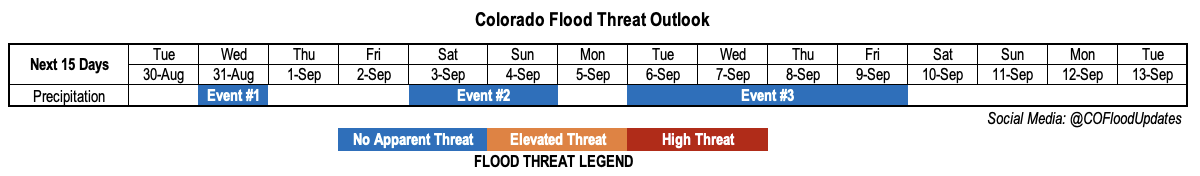
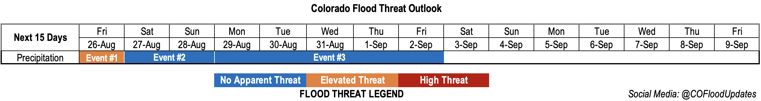
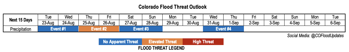
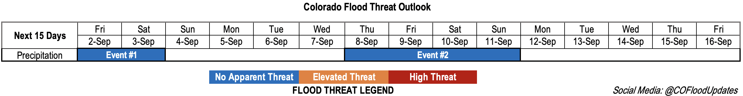
Valid Dates: 9/2 – 9/16

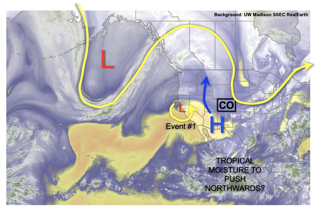
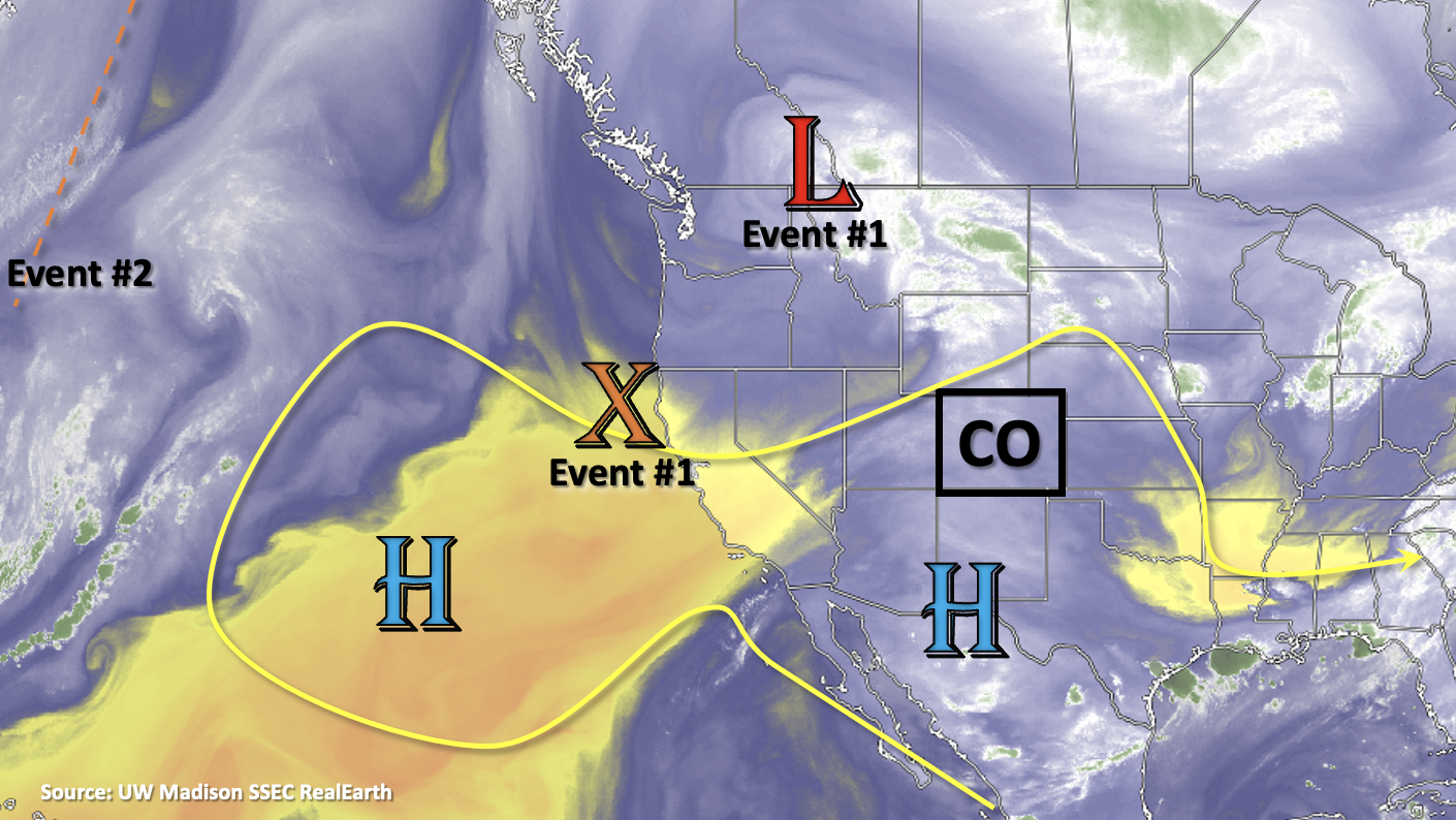
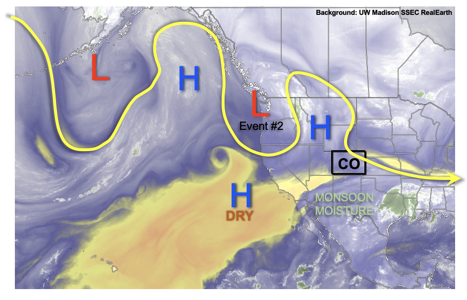
It’s officially meteorological fall today, although the well above average temperatures feel like it’s a continuation of summer. Above average temperatures are forecast through at least this next week with an upper-level ridge overhead. Event #1 is a quick 2-day event beginning tomorrow. Some diurnally driven storms are expected over the mountains with some isolated storms possible over the plains tomorrow. After Saturday, dry air should circulate around the building High, which should keep precipitation chances limited over Colorado next week. Event #2 is not expected to begin until the end of next week when flow could turn southerly and pull some tropical moisture northwards over the state. There is still a lot of uncertainty with this forecast as the plume could easily stay south and east of the state. Details should start to become clearer at the beginning of next week.

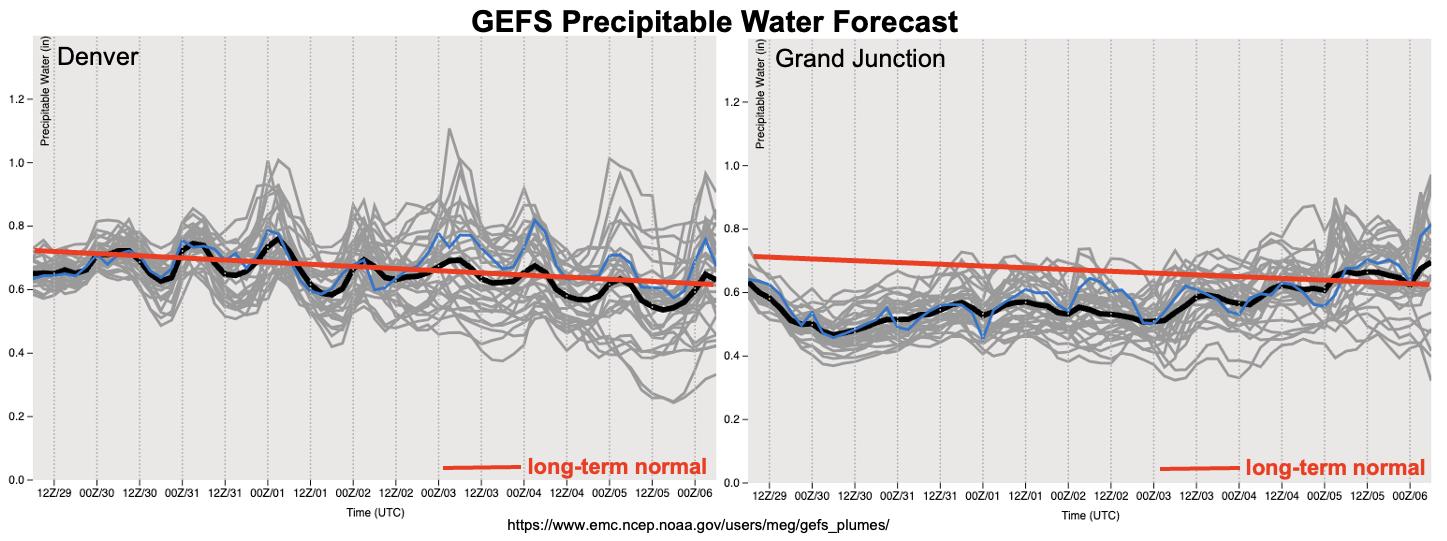
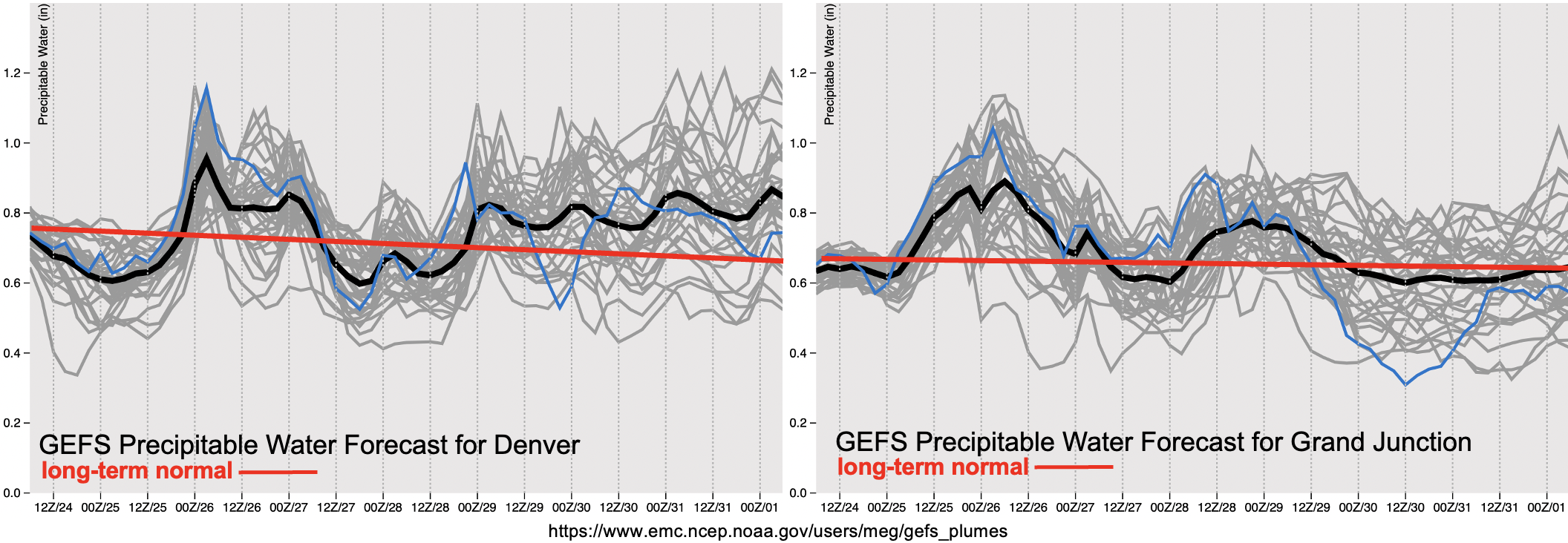
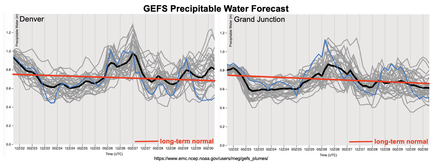
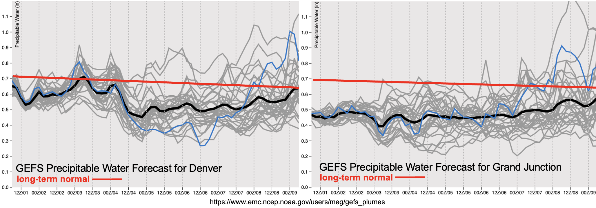
PW plumes are not overly impressive with values likely remaining below climatology through Thursday. There is a slight uptick in moisture over eastern Colorado tomorrow and Saturday behind a weak cold front. This front should help to produce isolated storms over the Southeast Mountains and possibly the adjacent plains tomorrow afternoon and evening. By Saturday, storms are expected to be confined to the mountains with northerly (north) and NNE (south) steering flows forecast. With only weak mid-level lift, quicker steering flows on Friday, and limited moisture, there is No Apparent flood threat issued for Event #1.

Event #1: Friday – Saturday (9/29/3)

No Apparent flood threat as weak dynamics and moisture produce isolated storms.

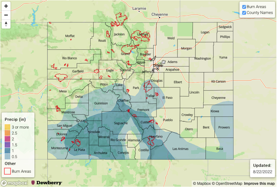
Isolated storms are forecast tomorrow over the mountains, Southeast Plains and elevated ridges. Storms that are able to develop over the adjacent plains along the boundary should have limited surface moisture, which means they could produce some strong outflow winds and plenty of virga. Over the mountains, isolated storms are most likely to develop along and near the Continental Divide and over the Southeast Mountains. There’s a better chance for widely scattered storms to develop over the southern high terrain on Saturday. During this period, storms should be short-lived and produce rain rates under 0.5 inches. Therefore, there is No Apparent threat has been issued.

Event #2: Thursday – Sunday (9/89/11)

Potential tropical moisture surge with added dynamics may cause an uptick in rainfall coverage, although at this time, there is No Apparent flood threat issued.

There’s a lot that can change over the next week and key ingredients that need to come together for Event #2. At the moment, long-term model guidance isn’t showing consensus either, so choosing to keep this forecast on the lower-end of the flood potential scale. A passing of a trough to our north, northward movement of the tropical moisture and the position/existence of a weak shortwave to our southeast will have to have the right timelines and tracks to get the moisture plume over the state. The likelihood of all the ingredients coming together is low, but stay tuned to the FTO on Monday as their will likely be an update to the forecast. At the most there would be a 1- or 2-day category upgrade to the event, but only if it looks more likely that the plume will move overhead.

FTO 08-29-2022: Mainly Dry and Warm Start To Fall, Then All Eyes Turn South…To The Tropics?

Issue Date: Monday, August 29th, 2022
Issue Time: 2:45PM MDT
Valid Dates: 8/30-9/13

After 79 straight days of precipitation somewhere across Colorado, the streak looks to finally end this week as drier air overtakes the state. At least briefly!

As shown in the water vapor image, below, a large-scale ridge is beginning to build across northwest North America. This will continue to evolve over the next 48 hours so that by mid-week, much above normal heat is expected along the US West Coast. Closer to home, however, the clockwise northerly flow around the expected ridge will promote subsidence. With only marginal moisture available, we expect a rather dry week for our state. At least compared to the past few months! Nonetheless, a couple of disturbances (Event #1 and Event #2) should support at least an isolated risk of shower and storm activity over the course of this week. Event #1 will occur on Wednesday, followed by another drier lull and then Event #2 this weekend. Flooding is not expected with either Event. Meanwhile, temperatures will continue to increase a bit and most of the state will see afternoon heat of 3-7F above normal values for early September.

Things turn interesting by next week as there is a surprising amount of consensus regarding the development of one or more tropical disturbances over the eastern tropical Pacific. As shown in the forecast GEFS PW, below, this will be occurring in a backdrop of higher moisture (see especially the Grand Junction forecast). Thus, showers and storms of modest intensity are likely to return to the Four Corners by early next week. Within Colorado, the best coverage will be along the climatologically preferred southern border, notably over the Southeast Mountains and San Juan Mountains. The flood threat will depend largely on the amount of tropical moisture that can trek up the western Mexico coast. In the absence of tropical moisture, it appears that the normal monsoonal dynamics and moisture will be too weak to support heavy rainfall capable of a flood threat. And with this situation being so far into the forecast, we do not expect flooding at this time. However, the next Outlook should be able to better assess the tropical moisture contribution, and whether a flood threat is needed.

The identified precipitation events are described in more detail below.

Event #1: Wednesday (August 31)

Isolated Showers and Weak Storms For Central Higher Terrain; No Apparent Flood Threat

Isolated to perhaps widely scattered showers and weaker storms are expected to return to the central higher terrain on Wednesday afternoon. Only 0.25 – 0.5 inches of precipitation is expected for lucky locations.

Event #2: Saturday – Sunday (September 3 – September 4)

Widely Scattered Storms For Central/Southern Higher Terrain; No Apparent Flood Threat

Isolated to widely scattered showers and weaker storms are expected on Saturday and Sunday afternoons. Best coverage looks to be over the southern Front Range and Southeast Mountains on Saturday, shifting towards the central and southwestern higher terrain by Sunday. Max 30-minute rainfall up to 0.5 inches looks possible, along with gusty winds.

Event #3: Tuesday – Friday (September 6 – September 9)

Showers and Storms Return, Mainly Along Southern Border; No Apparent Flood Threat At This Time

An prolonged increase in thunderstorm activity is expected by early next week as monsoonal moisture returns to the state. At this time, it appears there will be a strong gradient in the moisture, implying that only the southern one-third of Colorado looks to see meaningful precipitation. Widely scattered to scattered storms are expected mainly over the climatologically preferred Southeast Mountains and San Juan Mountains each afternoon and evening. At this time, max 30-min rainfall looks to be limited to 0.5-0.6 inches, thus flooding is not expected. However, the next Outlook should have a better assessment of whether a (low-end) threat is needed.

FTO 08-25-2022: Quick One Day Elevated Threat Before A Quieter Pattern

Issue Date: Thursday, August 25th, 2022
Issue Time: 2:40PM MDT
Valid Dates: 8/26 – 9/9

Today is the 75th consecutive day with precipitation occurring somewhere across Colorado, but as mentioned in Monday’s FTO there finally looks to be a slowdown to this long monsoon season on the horizon. Below are the top 10 counties that have received the highest mean total precipitation since the first monsoon surge (mid-June) according to PRISM (4km resolution). Also included are the NRCC Interpolated (5km resolution) QPE values, which show similar results in rankings (not shown) but slightly less magnitude. All, except for one county, are located in the San Juan Mountain and Southeast Mountain forecast zones, which are well known hot spots for summer rainfall. The San Juan Mountains have been highlighted numerous times in FTB products this season for flood threats and multi-day rainfall events. Compared to 2021, where the highest mean total precipitation was 8.34 inches (San Juan County), the 2022 monsoon season has been longer, stronger and more widespread in nature. This has been great news for suppressing fire danger and (mostly) improving drought conditions.

Below in the water vapor image, the broad High pressure pattern over the southwest US is expected to break down today with the trough and shortwaves moving through the flow (Event #1). With some higher monsoon moisture values over the state, as shown by the small PW surge in the plumes, and stronger mid-level dynamics present, a quick one-day Elevated flood threat has been issued for Friday. An increase in subsidence and decreasing PW values behind the trough should keep storms more widely scattered over the mountains this weekend (Event #2). Then, by the end of this weekend, building High pressure over the Colorado and the western US, along with the return of near normal PW values are likely return warmer temperatures and afternoon storms (Event #3). The forecast gets a little bit tricky with guidance showing a shortwave potentially becoming cutoff from the main flow over eastern Colorado at the beginning of the week. Depending on its location, it could help produce a dry day or two over the state by keeping the better moisture east and south. Generally, storm activity is expected to be limited during Event #3, so there is No Apparent flood threat issued.

Event #1: Friday (8/26)

Mid-level lift and above average moisture will likely return the flood threat to southern Colorado causing a one-day Elevated flood threat to be issued.

Relatively widespread rainfall is forecast tomorrow with the best chance for convective, heavy rainfall producing storms to occur over the central/southern high terrain and elevated ridges. Max 30-minute/1-hour rain rates up to 1/2 inches will be possible causing an Elevated flood threat to be issued. Stronger storms (south) and dissipating storms where there are larger dew point depressions (north) may also produce some strong wind gusts. Over the adjacent eastern plains, hail may accompany some of the more intense thunderstorms that develop.

Event #2: SaturdaySunday (8/27 – 8/28)

Residual moisture and upslope flow will likely cause isolated to widely scattered mountain storms, No Apparent flood threat issued.

While there may be some weak mid-level dynamics moving through the flow, subsidence in the wake of the trough and drying should limit storm coverage over the weekend. Outsides of some diurnally driven mountain storms, it is expected to remain dry. Max 30-minute/1-hour rain rates up to 0.6/0.8 inches will be possible with storms develop mostly occurring along and near the Continental Divide.

Event #3: MondayFriday (8/299/2)

No Apparent flood threat with building high pressure and limited moisture.

As mentioned above, there is still some uncertainty with the forecast during this period as guidance is indicating that some mid-level energy may get pinched off from the main flow to start the week. This event should have the best shot at producing a long-awaited dry day, but only if moisture can be held off to the east and south by the position of the shortwave. Best shot for this dry day would be on Tuesday or Wednesday. Storm activity is forecast to be limited during this event with most of western Colorado remaining dry. Max 30-minute rain rates look to stay under 0.6 inches at this time.

FTO 08-22-2022: Another Monsoon Surge On The Way – Our Last One?

Issue Date: Monday, August 22nd, 2022
Issue Time: 2:20PM MDT
Valid Dates: 8/23 – 9/6

Today will mark the 72nd consecutive day with precipitation somewhere across Colorado, and last Outlook’s prediction that we will easily get to 75 looks on course. Several weeks ago, we presented moisture anomalies that have accompanied the active rainy weather over the Four Corners. Below is an updated analysis, showing PW (left) and low-level relative humidity (right) anomalies since mid-June, when the monsoon turned on in earnest. Note that the legends are flipped, with blue/purple values corresponding to below normal PW but above normal relative humidity. We can see that above normal moisture has occurred over a wide stretch of the southwest United States, in association with an anomalous ridge centered over the southern Great Plains (not shown). Compared to several weeks ago, moisture anomalies have also expanded a bit westward. Over Colorado, the surplus moisture has not benefited everyone equally with southern and southwestern sections of the state doing much better job of translating the moisture into actual rainfall. In this Outlook, we are finally seeing signs of a major pattern shift away from what we have seen over the past few months. In short, with the upper-level ridge weakening, monsoonal moisture will generally decrease statewide but not before another pulse later this week.

As shown in the water vapor image, below, a very amplified pattern is noted this afternoon across the eastern Pacific Ocean and western North American continent. Close to home, a departing disturbance will lead to mid-level height rises and general subsidence through Wednesday. Pleasant weather and only isolated to widely scattered weaker storms are expected through this time (Event #1). By Thursday, a currently stationary upper-level low pressure over the Pacific Northwest will begin to move southeast, bringing in a surge of moisture from both the northwest and south. A increase in storm activity is expected through Friday, with an Elevated flood threat anticipated for mainly the higher terrain (Event #2). Subsidence behind the departing disturbance should drop rain intensity to below flood thresholds by Saturday and Sunday, though widely scattered storms are still possible over the central and southern high terrain.

As shown in the forecast PW plumes, below, significant drying is expected in the wake of Event #2 so that Monday or Tuesday of next week look to be our earliest chance of a dry day statewide. Thereafter, with a weak ridge developing over or just north of Colorado, monsoonal moisture should stay suppressed south of us. However, enough moisture could creep into the San Juan Mountains for an uptick in storm activity by the middle of next week. Flooding is not expected at this time.

Temperatures statewide are expected to run fairly close to seasonal normal, so that a nice stretch of late summer days looks to be on the menu for many folks.

The identified precipitation events are described in more detail below.

Event #1: Tuesday – Wednesday (August 23 – August 24)

No Apparent Flood Threat But Isolated To Widely Scattered Weak Storms Expected Over Southern High Terrain

Afternoon and evening storms are expected daily, though max 30-min rain rates should stay at 0.6 inches or lower, preventing any flood threat.

Event #2: Thursday – Friday (August 25 – August 26)

Low-end Elevated Flood Threat Returns To Southern And Central Higher Terrain

Scattered to numerous storms are expected on Thursday and Friday. Highest coverage over the northern and central high terrain on Thursday, shifting southward to the central and southern high terrain by Friday. Max 30-min / 60-min rain intensity up to 0.9 and 1.2 inches warrant an low-end Elevated flood threat mainly for steeper terrain.

Eastward over the lower elevations, rainfall will be more in the isolated to widely scattered variety. However, a few stronger or even severe storms could form over the Southeast Plains towards the KS and OK border on Friday. An Elevated flood threat could materialize for a small portion of this area, contingent upon the storms forming far enough westward.

Event #3: Saturday – Sunday (August 27 – August 28)

No Apparent Flood Threat, But Isolated Storms Still Expected For Higher Terrain

With moisture on the decrease and weak subsidence overhead, storm coverage will drop into the isolated to scattered variety by Saturday. Still, max 30-min rainfall up to 0.5 inches could occur over the climatologically preferred San Juan Mountains and Southeast Mountains. However, flooding is not currently expected.

Event #4: Wednesday – Thursday (August 31 – September 1)

Storm Chances To Increase For Far Southern High Terrain; No Apparent Flood Threat

With moisture moving in from the east/southeast, enough of it could graze our southern border counties and produce widely scattered showers and storms. Max 30-minute rain rates up to 0.5 inches are possible, but flooding is not expected at this time.