Issue Date: Thursday, August 25th, 2022
Issue Time: 2:40PM MDT
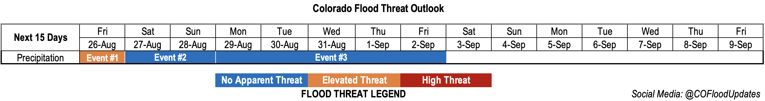
Valid Dates: 8/26 – 9/9
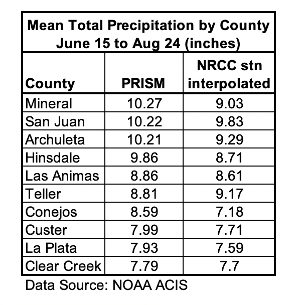
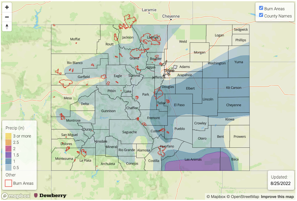
Today is the 75th consecutive day with precipitation occurring somewhere across Colorado, but as mentioned in Monday’s FTO there finally looks to be a slowdown to this long monsoon season on the horizon. Below are the top 10 counties that have received the highest mean total precipitation since the first monsoon surge (mid-June) according to PRISM (4km resolution). Also included are the NRCC Interpolated (5km resolution) QPE values, which show similar results in rankings (not shown) but slightly less magnitude. All, except for one county, are located in the San Juan Mountain and Southeast Mountain forecast zones, which are well known hot spots for summer rainfall. The San Juan Mountains have been highlighted numerous times in FTB products this season for flood threats and multi-day rainfall events. Compared to 2021, where the highest mean total precipitation was 8.34 inches (San Juan County), the 2022 monsoon season has been longer, stronger and more widespread in nature. This has been great news for suppressing fire danger and (mostly) improving drought conditions.
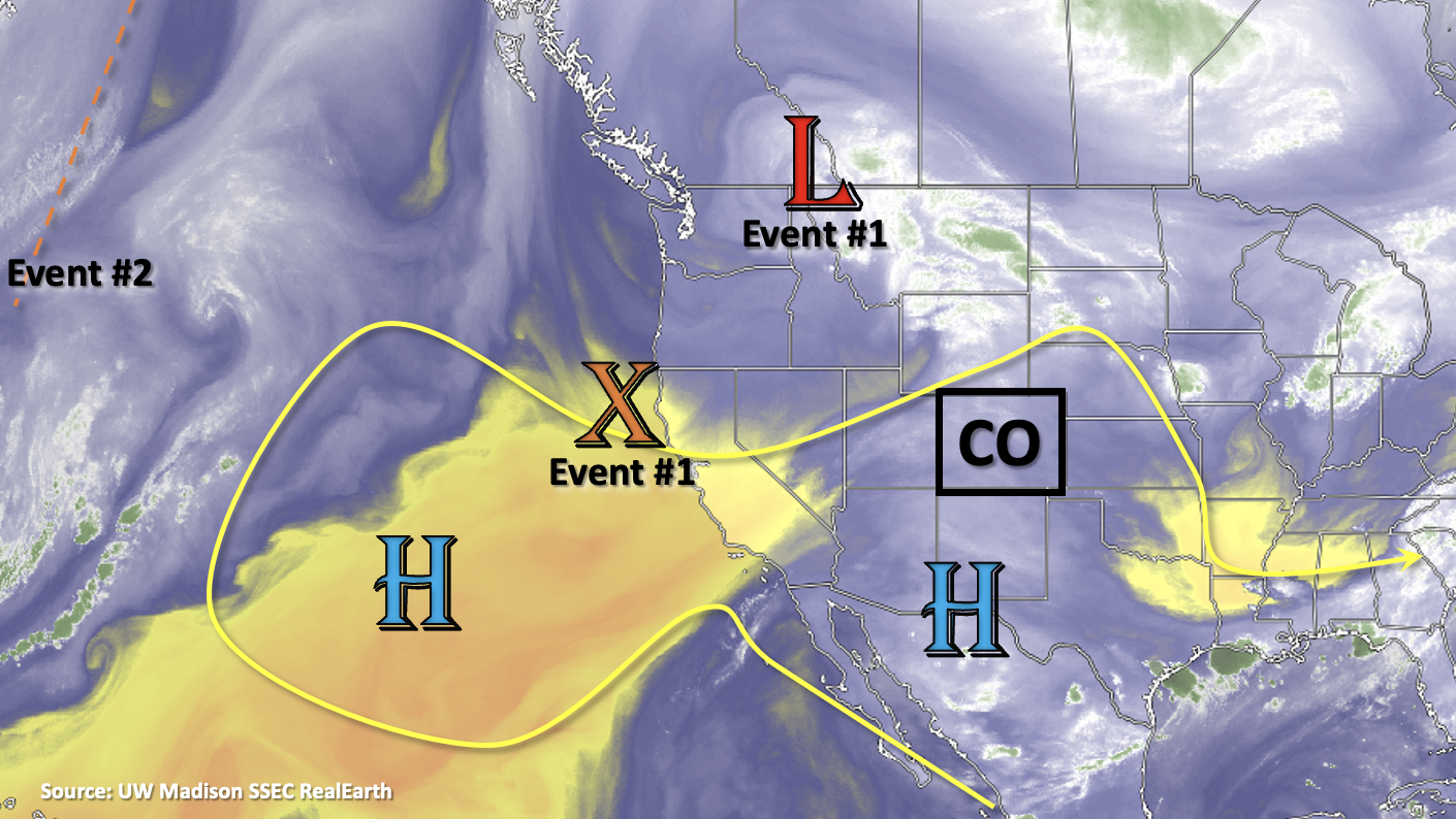
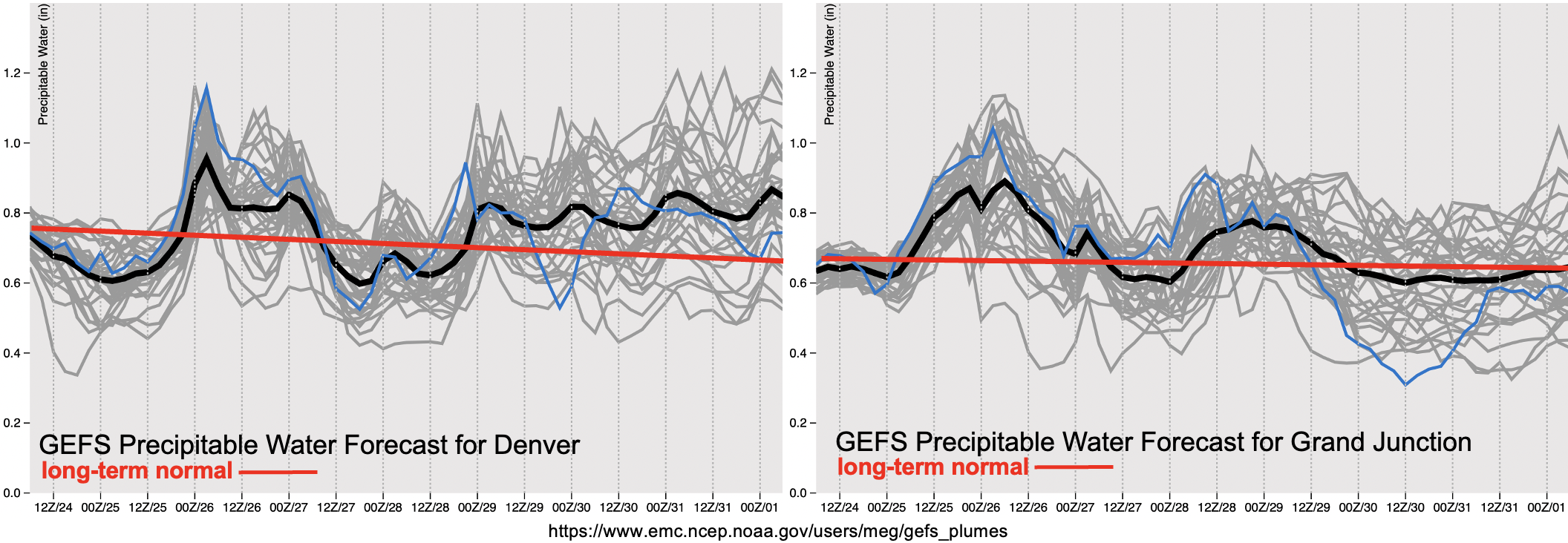
Below in the water vapor image, the broad High pressure pattern over the southwest US is expected to break down today with the trough and shortwaves moving through the flow (Event #1). With some higher monsoon moisture values over the state, as shown by the small PW surge in the plumes, and stronger mid-level dynamics present, a quick one-day Elevated flood threat has been issued for Friday. An increase in subsidence and decreasing PW values behind the trough should keep storms more widely scattered over the mountains this weekend (Event #2). Then, by the end of this weekend, building High pressure over the Colorado and the western US, along with the return of near normal PW values are likely return warmer temperatures and afternoon storms (Event #3). The forecast gets a little bit tricky with guidance showing a shortwave potentially becoming cutoff from the main flow over eastern Colorado at the beginning of the week. Depending on its location, it could help produce a dry day or two over the state by keeping the better moisture east and south. Generally, storm activity is expected to be limited during Event #3, so there is No Apparent flood threat issued.
Event #1: Friday (8/26)
Mid-level lift and above average moisture will likely return the flood threat to southern Colorado causing a one-day Elevated flood threat to be issued.
Relatively widespread rainfall is forecast tomorrow with the best chance for convective, heavy rainfall producing storms to occur over the central/southern high terrain and elevated ridges. Max 30-minute/1-hour rain rates up to 1/2 inches will be possible causing an Elevated flood threat to be issued. Stronger storms (south) and dissipating storms where there are larger dew point depressions (north) may also produce some strong wind gusts. Over the adjacent eastern plains, hail may accompany some of the more intense thunderstorms that develop.
Event #2: Saturday – Sunday (8/27 – 8/28)
Residual moisture and upslope flow will likely cause isolated to widely scattered mountain storms, No Apparent flood threat issued.
While there may be some weak mid-level dynamics moving through the flow, subsidence in the wake of the trough and drying should limit storm coverage over the weekend. Outsides of some diurnally driven mountain storms, it is expected to remain dry. Max 30-minute/1-hour rain rates up to 0.6/0.8 inches will be possible with storms develop mostly occurring along and near the Continental Divide.
Event #3: Monday – Friday (8/29 – 9/2)
No Apparent flood threat with building high pressure and limited moisture.
As mentioned above, there is still some uncertainty with the forecast during this period as guidance is indicating that some mid-level energy may get pinched off from the main flow to start the week. This event should have the best shot at producing a long-awaited dry day, but only if moisture can be held off to the east and south by the position of the shortwave. Best shot for this dry day would be on Tuesday or Wednesday. Storm activity is forecast to be limited during this event with most of western Colorado remaining dry. Max 30-minute rain rates look to stay under 0.6 inches at this time.