Issue Date: Monday, August 29th, 2022
Issue Time: 2:45PM MDT
Valid Dates: 8/30-9/13
After 79 straight days of precipitation somewhere across Colorado, the streak looks to finally end this week as drier air overtakes the state. At least briefly!
Colorado has not seen a dry day statewide since June 10th – a stretch of 79 straight days with rain! It's probably not coincidence that there is no ongoing #cofire activity. But, the wet streak may finally end this week. #cowx #coflood pic.twitter.com/CsBCitfkvJ
— Colorado Flood Threat Bulletin (@COFloodUpdates) August 29, 2022
As shown in the water vapor image, below, a large-scale ridge is beginning to build across northwest North America. This will continue to evolve over the next 48 hours so that by mid-week, much above normal heat is expected along the US West Coast. Closer to home, however, the clockwise northerly flow around the expected ridge will promote subsidence. With only marginal moisture available, we expect a rather dry week for our state. At least compared to the past few months! Nonetheless, a couple of disturbances (Event #1 and Event #2) should support at least an isolated risk of shower and storm activity over the course of this week. Event #1 will occur on Wednesday, followed by another drier lull and then Event #2 this weekend. Flooding is not expected with either Event. Meanwhile, temperatures will continue to increase a bit and most of the state will see afternoon heat of 3-7F above normal values for early September.
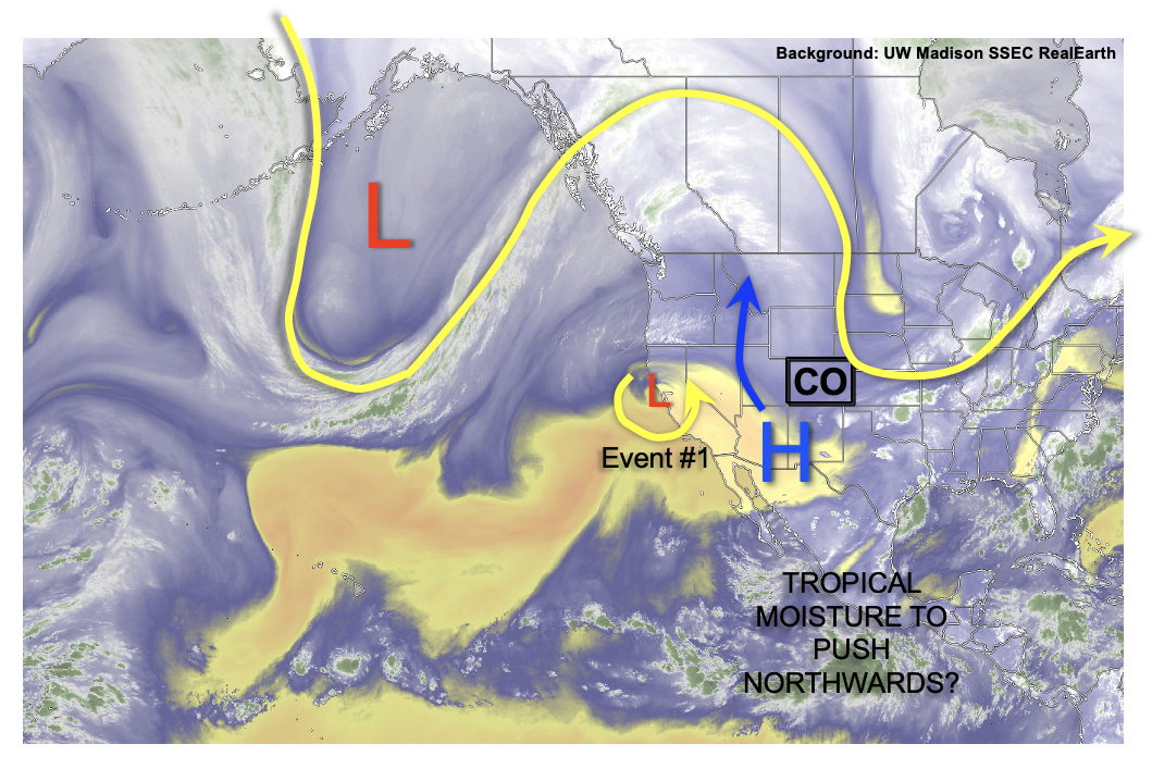
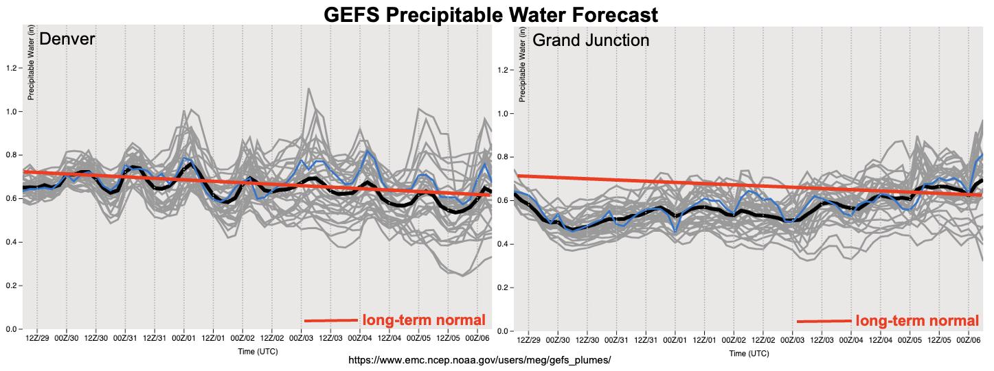
Things turn interesting by next week as there is a surprising amount of consensus regarding the development of one or more tropical disturbances over the eastern tropical Pacific. As shown in the forecast GEFS PW, below, this will be occurring in a backdrop of higher moisture (see especially the Grand Junction forecast). Thus, showers and storms of modest intensity are likely to return to the Four Corners by early next week. Within Colorado, the best coverage will be along the climatologically preferred southern border, notably over the Southeast Mountains and San Juan Mountains. The flood threat will depend largely on the amount of tropical moisture that can trek up the western Mexico coast. In the absence of tropical moisture, it appears that the normal monsoonal dynamics and moisture will be too weak to support heavy rainfall capable of a flood threat. And with this situation being so far into the forecast, we do not expect flooding at this time. However, the next Outlook should be able to better assess the tropical moisture contribution, and whether a flood threat is needed.
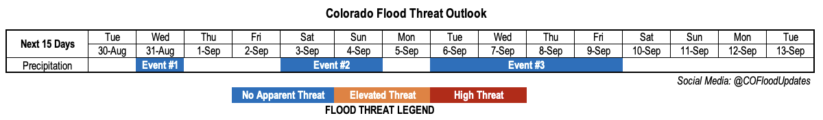
The identified precipitation events are described in more detail below.
Event #1: Wednesday (August 31)
Isolated Showers and Weak Storms For Central Higher Terrain; No Apparent Flood Threat
Isolated to perhaps widely scattered showers and weaker storms are expected to return to the central higher terrain on Wednesday afternoon. Only 0.25 – 0.5 inches of precipitation is expected for lucky locations.
Event #2: Saturday – Sunday (September 3 – September 4)
Widely Scattered Storms For Central/Southern Higher Terrain; No Apparent Flood Threat
Isolated to widely scattered showers and weaker storms are expected on Saturday and Sunday afternoons. Best coverage looks to be over the southern Front Range and Southeast Mountains on Saturday, shifting towards the central and southwestern higher terrain by Sunday. Max 30-minute rainfall up to 0.5 inches looks possible, along with gusty winds.
Event #3: Tuesday – Friday (September 6 – September 9)
Showers and Storms Return, Mainly Along Southern Border; No Apparent Flood Threat At This Time
An prolonged increase in thunderstorm activity is expected by early next week as monsoonal moisture returns to the state. At this time, it appears there will be a strong gradient in the moisture, implying that only the southern one-third of Colorado looks to see meaningful precipitation. Widely scattered to scattered storms are expected mainly over the climatologically preferred Southeast Mountains and San Juan Mountains each afternoon and evening. At this time, max 30-min rainfall looks to be limited to 0.5-0.6 inches, thus flooding is not expected. However, the next Outlook should have a better assessment of whether a (low-end) threat is needed.