FTO 07-06-2020: Summer Heat Wave

Issue Date: Monday, July 6th, 2020
Issue Time: 2:25PM MDT
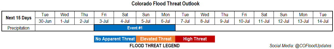
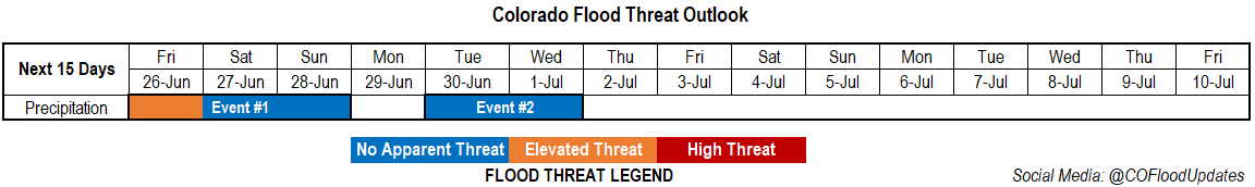
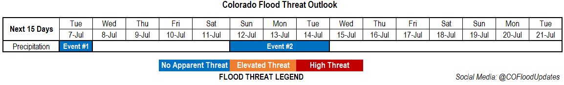
Valid Dates: 7/7– 7/21

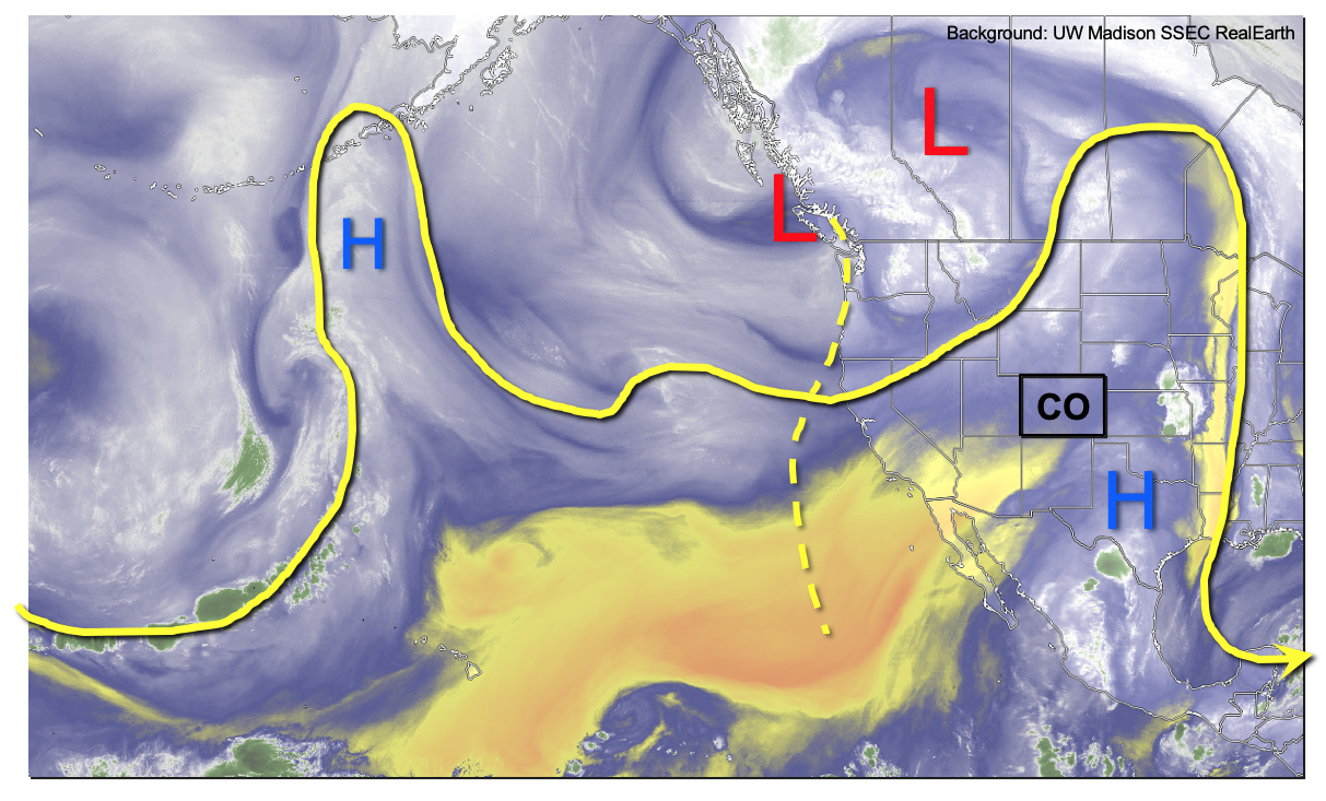
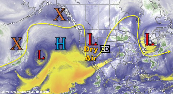
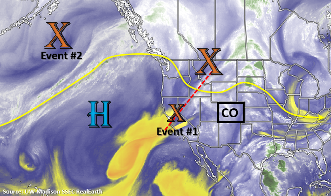
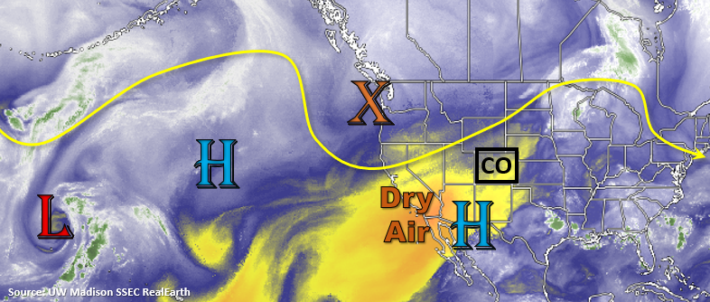
Temperatures are on the rise with a moderately strong ridge overhead, and dry air is beginning to settle in across the state. This can be seen in the water vapor imagery below by the yellow shades over Colorado. Tomorrow will be the last shot at some weak thunderstorms and showers as the trough (orange “X”) transitions east and propagates some mid-level energy across the state. Due to the lack of boundary layer moisture, storms are likely to produce more wind than rainfall. High fire danger will return to western Colorado, the western mountains, and portions of the Southeast Mountains as southwest surface winds are expected to increase and couple with low relative humidity values. The best chance for wetting rainfall will be east of the mountains across the adjacent plains where a little better low-level moisture should exist.

Behind the trough, the heat is on as the ridge rebuilds over the state and westerly flow continues to scour out any of the remaining moisture. This is likely to be our first real heat wave of the summer with highs reaching the upper 90Fs to 100F across all the lower elevations by tomorrow. There may be some weak cooling on Thursday, but it will hardly be noticeable with highs still in the 90Fs. The extreme heat is expected ramp right back up, and temperatures over the eastern plains will push 105F by the week’s end. Expect the heat to last through the weekend.

Storm chances return Sunday into Tuesday (Event #2), which should help some lucky areas cool off during the afternoon over south, central Colorado. The increase in storm activity occurs due to the ridge axis shifting slightly east, and moisture  wrapped around the High moving over the state. There looks to be a (potential) tropical cyclone that forms over the eastern Pacific and travels northward along the Baja Peninsula. This could help pull some decent moisture northward on the west side of the high, so this interaction with the High and storm track/intensity of the potential TC will be watched closely throughout the week.

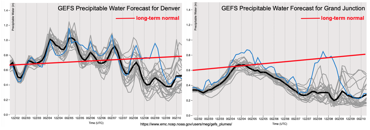
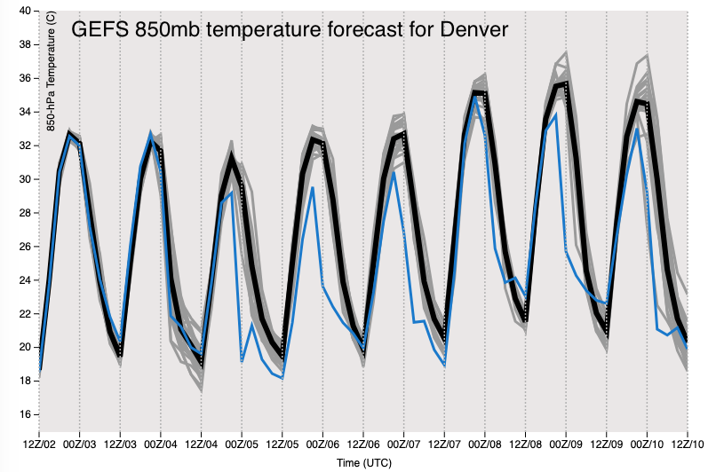
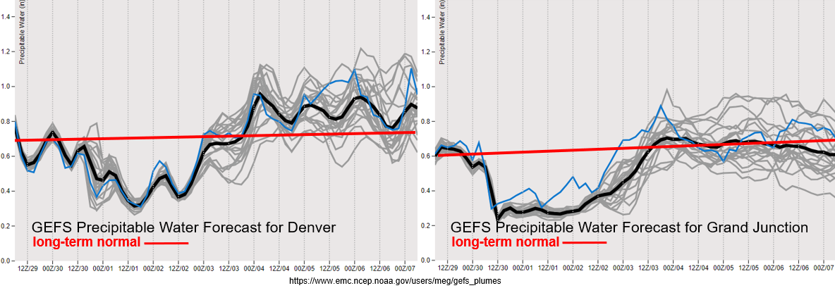
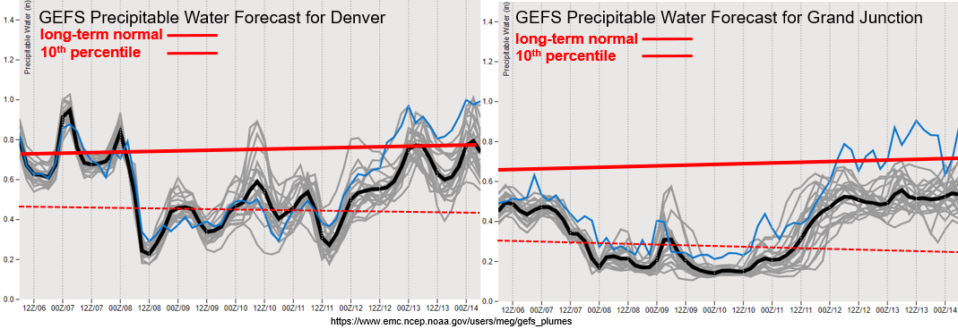
I’ve added the 10th percentile climatology to the GEFS PW plumes below to show just how dry it’s going to get on top of the heat. Record low values will be possible over western Colorado, which is not good news as this area is already experiencing a drought. PW also drops off significantly over eastern Colorado as well and hovers around the 10% climatology by Wednesday morning. All in all, please use extreme caution as fire danger will be elevated with already dry fuels and very hot temperatures forecast. The nice ramp up in moisture can be seen at the end of the week, and there is pretty good consensus among the different model members this far out. Saturday may allow for a few scattered storms over the southern mountains, but the boundary layer will still be quite dry, so not expecting much rainfall.

Event #1: Tuesday (7/7)

No Apparent Threat as the trough pushes some mid-level energy overhead and it mixes with limited low-level moisture to produce scattered storms over eastern Colorado.

The boundary layer is expected to be even more dry tomorrow, which will really rainfall efficiency with most of the droplets evaporating before the reach the surface. There is a slight chance that rain totals could reach 0.50 inches along the Raton Ridge, but this would be very isolated in nature. Small hail is also not out of the question under one of these stronger storms. Storms that are able to form tomorrow will likely produce gusty outflow winds and lightning, which seems to be the main threat from storms lately. Flooding is not expected so there is No Apparent Flood threat issued. A Red Flag Warning has been issued for western Colorado with a Fire Weather Watch for the majority of the mountains. Tune into your local NWS office and tomorrow’s FTB for more information.

Event #2: SundayTuesday (7/12 – 7/14)

No Apparent Threat as moisture gets wrapped northward around the High and moves into the state with a slight eastward shift of the ridge axis.

After a very dry and hot week, moisture begins to return to the state on Saturday. It still looks to be pretty dry over western Colorado, so expect storms to be confined to the Central and San Juan Mountains along and near the Continental Divide starting on Sunday. Better storm formation is expected over the Southeast Mountains and southern Front Range. Without much upper dynamical support, storms will likely be pulse-like in nature. A few may wander into the immediate adjacent plains with the counterclockwise flow, which is typical with this diurnally driven pattern. If any shortwaves arrive at peak heating, coverage of storms will likely increase over the eastern mountains and over the immediate adjacent plains, but it’s too far out to know any of those details yet. As for the rainfall chances, best guess now is that coverage will be greatest further south and east. As is typical, the GFS has a lot more moisture than the ECMWF, so we’ll continue to watch model trends throughout this week.

FTO 07-02-2020: Rainfall Returns for July 4th Weekend; Intense Heat To Follow

Issue Date: Thursday, July 2nd, 2020
Issue Time: 2:25PM MDT
Valid Dates: 7/03 – 7/17

The afternoon’s water vapor imagery, below, shows an amplified pattern over the eastern Pacific Ocean and stretching into the central United States. Amplified patterns sometimes result in active weather, but such is absolutely not the case in this situation. A large ridge, currently centered just east of Colorado, will be almost stationary over the next 7-10 days, resulting in little to no movement of water vapor in or out of the state. Meanwhile, a large-scale trough over southwest Canada will attempt to usher in shortwave ripples in the flow. Ultimately, the ridge will remain in control, but not before a 72-96 hour event of increased precipitation chances mainly across central and eastern Colorado. This is the only precipitation event identified during this Independence Day Weekend-edition of the Outlook.

Looking at the PW plumes from the GFS ensemble shows a marked difference across the Continental Divide. While Denver will see a prolonged stretch of above normal moisture, Grand Junction will stay generally below normal. Thus, expect to see little to no precipitation below about 8,000 feet west of the Continental Divide, with precipitation limited to about 0.5 inches for the higher elevations of the San Juan Mountains and Central Mountains. The area likely to see the highest rainfall amounts will be across the far eastern and southeastern Colorado border. There, plenty of residual moisture will be trapped with PW up to 1.3 inches along the southern border with Kansas. Although synoptic scale support will be rather weak, there will be sufficient instability for a 48 hour stretch of isolated heavy rainfall, warranted an Elevated flood threat for the Saturday-Sunday timeframe. This is certainly good news given the recent upgrade to extreme drought status for parts of southeast Colorado.

The aforementioned ridge is expected to take firm control of Colorado’s weather beginning Tuesday of next week (July 7th), as is clearly seen in the GFS ensemble forecast of 850 mb temperatures for Denver. Expect a 3+ day stretch of much above normal temperatures, reaching 100F even for elevations up to 5,500 feet. The prospects for widespread rainfall look very slim from Tuesday July 7th, onward. However, residual moisture could still produce higher terrain showers and storms depending on how much moisture is available in the boundary layer. However, at this time, precipitation amounts above 0.5 inches do not appear likely.

Event #1 is outlined in more detail.

Event #1: Friday (6/26) – Monday (6/29)

Elevated Threat on Saturday and Sunday with heavy rainfall possible along the Kansas border

Rainfall coverage will increase on Friday, with the highest coverage over the higher terrain as well as northeast Colorado where isolated severe storms will be possible. On Saturday and Sunday, the southeast quadrant of the state is expected to see the most activity, with one or two rounds of afternoon and evening showers and thunderstorms possible. Rainfall rates in the higher terrain are expected to stay at or below 0.5 inches so no flooding is anticipated, though the Decker and Spring Creek burn scars will need to be watched. Farther southeast, rainfall rates up to 2.4 inches per hour look to be possible across far southeast Colorado, as PW approaches 1.3 inches. Exact placement of storms will depend on mesoscale boundaries and the dryline position. Check back to daily Flood Threat Bulletins for updates.

FTO 06-29-2020: Drying Trend before Rain Returns for the Holiday Weekend

Issue Date: Monday, June 29th, 2020
Issue Time: 1:20PM MDT
Valid Dates: 6/30 – 7/14

High fire danger will continue on Tuesday as the Low remains to our west and mixes high wind speeds down to the surface. The main difference from today is that it will be cooler across the state due to a cold front moving through overnight. Not much low-level moisture is associated with the front, and it quickly mixes out tomorrow, so wetting rainfall is not forecast for Tuesday. Outside of some very light rainfall over the northwest corner, it should remain dry. The Low will begin to lift northward and a ridge will build from east to west across the state the rest of the week. So enjoy the cool tomorrow as it won’t last for more than a day or so. By Friday, Event #1 begins as the High becomes centered over the desert southwest. This will start to pull higher moisture northward and move weak disturbances across the state (dirty ridge). The ridge becomes dislodged and begins to move east by early next week as the next trough approaches from the west. Thus, rainfall chances should start to decrease.

As far as moisture, the GEFS shows it really starting to drop off after today both east and west as the southwest flow aloft entrains a very dry air mass. Values over western Colorado are near record low values, so very high fire danger is anticipated on Tuesday. Tune into your local NWS office for the latest on Red Flag Warnings. The uptick in moisture associated with the building High can be seen later this week as well. We’ll watch how much moisture moves northward across the southern border over this week, but at this time there is No Apparent Threat. If the PW values are on the higher end of the GEFS solutions below, it is likely that on Friday or Saturday an Elevated Threat will be issued. Please tune back in on Thursday for the latest as details will likely change. We’ll also be able to better place an Elevated flood threat for recent burn areas this weekend. Nevertheless, slower steering winds under the ridge later this week will allow storms to drop beneficial, wetting rainfall.

Event #1: Friday (7/3) – Monday (7/6)

No Apparent Threat as the High sets up over the Desert Southwest and advects subtropical moisture northward.

It’s going to be hot this week with the 5880m marker moving north of the state by Thursday. The aforementioned uptick in moisture should bring storms back into the forecast by late this week. Weaker showers on Thursday will likely help moisten the boundary layer, which will allow more substantial rain to fall on Friday/into the weekend. Without much steering flow at the upper levels, storms should mostly stay confined to the mountains and immediate adjacent plains. This will also help accumulate rainfall over certain areas. At this time, the best chance for widespread showers and thunderstorms will be on Sunday, but a lot of details can change over the next few days. Tune back into the FTO on Thursday for the latest. Lastly, I just want to quickly mention there is an Elevated flood threat for Event #1 over recent burn areas due to the slower steering winds aloft. I only mention that now due to the holiday weekend and the increase in mountain recreation. It’s a bit too far to say much more than that due to low confidence in the details.

FTO 06-25-2020: Heavy Rainfall and Severe Thunderstorms Forecast for the Eastern Plains on Friday

Issue Date: Thursday, June 25th, 2020
Issue Time: 1:30PM MDT
Valid Dates: 6/26 – 7/10

Event #1 continues tomorrow as a shortwave breaks off the main flow and begins to dig south over California. This will change the flow aloft to more westerly and release some mid-level energy into the state for additional afternoon lift. The trough to our north will also push a cold front south this evening, which will cool temperatures off and allow decent low-level moisture to return for more widespread, organized rainfall over the mountains and adjacent plains on Friday. The moisture rich environment paired with better upper level dynamics will likely produce a few severe thunderstorms and heavy rainfall over eastern Colorado.

From Saturday into Sunday, the next trough quickly moves eastward (Event #2). This will help push the California vorticity max (Event #1) through the state, and the vorticity max (Event #2) quickly strengthens into a closed Low system. Event #2 will produce southwest flow aloft, which is expected to pull in drier air over the state from Sunday into Monday. This may cause some critical fire weather for western Colorado as the jet rotates around the base of the trough. Additionally, the drier air mass will reduce afternoon rainfall chances Sunday and likely produce dry conditions on Monday. As Event #2 exits northward (blocking Low to the east), some light rainfall may be possible over the northern mountains and immediate adjacent plains. Expected enhanced fire weather through at least mid-week.

The site for the GEFS plumes is currently down, and with no fix in sight, I had to get a little creative today. Below is the 12Z (or morning) run of the HRRR showing dew points over Colorado at midnight tonight. The first thing you should notice is the very dry air mass over the southwest corner and the very moist air mass over the northern border/eastern Colorado. The reason for the high moisture over eastern Colorado is the cold front dropping south. Dew points behind the front increase 10-15F! While there may be a little drying at the mid-levels along the Urban Corridor throughout the day on Friday with weak westerly flow aloft, it remains quite moist over the eastern plains. This will translate into very efficient rain rates with moderate steering flows for storms; thus, an Elevated flood threat is issued. Unfortunately, the dry air over southwestern Colorado will remain intact and confine scattered, afternoon storms to the mountains and elevated terrains over the Grand Valley, Northwest Slope, Northern Mountains and Central Mountains.

For a look at Event #2, the GEFS 6-8 day (valid Tuesday, Wednesday, and Thursday) chance of precipitation > 0.50 inches was pulled. While there may be some issues with topography due to the coarse resolution of the model, outside of the northeast corner of the state, chances of accumulations greater than 0.50 inches are less than 30% over this period. This just illustrates that there will not be much moisture associated with Event #2, and the main hazard will be critical fire weather for Colorado – especially western Colorado.

Event #1: Friday (6/26) – Sunday (6/28)

Elevated Threat/No Apparent Threat as a cutoff vorticity max brings extra mid-level energy to a moist air mass over eastern Colorado.

Friday should have more organized thunderstorms when compared to the last couple of days. A couple of these could become severe over the eastern plains with heavy rainfall, large hail (>1.25 in), and wind gusts (60 mph) possible. The wind threat will increase as storms become more of a MCS/bow echo over the plains. Outflow boundaries will help trigger additional convection for more widespread coverage as they move off the mountains by early afternoon. Storms are expected to cross into Kansas and Nebraska around midnight.

On Saturday, residual moisture may cause some storms to form over the Central, Northern and Front Range Mountains. With storm motion from the southwest to northeast, storms should spread into the Urban Corridor, Palmer Ridge, and Northeast Plains. With drier low levels the main threat will be gusty outflow winds and moderate rainfall. Even fewer storms are anticipated to form over the mountains on Sunday.

Event #2: TuesdayWednesday (6/30 7/1)

No Apparent Threat as the closed Low lifts northwards out of the state.

As mentioned above, the main threat will be fire danger for Event #2 over Colorado. Rain will likely return to the northern portion of the state for one of these days, but little to no accumulation is forecast. The image below just shows the area that will likely receive a little precipitation, but I have very low confidence that totals will reach 0.50 inches with the dry and abnormally strong system. Storms will also be moving quickly with the jet overhead, which will help to reduce totals. Expecting temperatures to reach near the triple digits on Sunday afternoon over the far eastern plains. So be sure to get in your afternoon activities on Saturday.