Issue Date: Thursday, June 25th, 2020
Issue Time: 1:30PM MDT
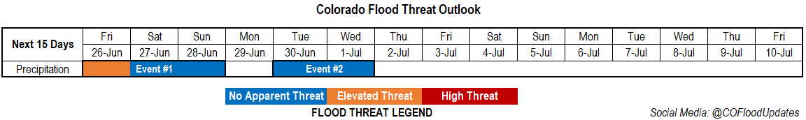
Valid Dates: 6/26 – 7/10
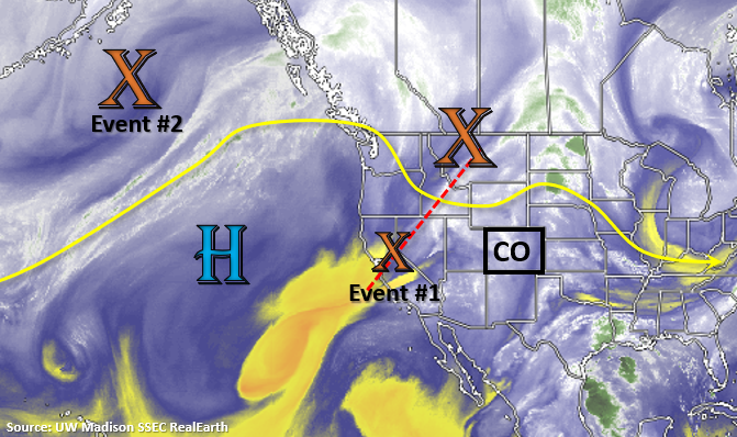
Event #1 continues tomorrow as a shortwave breaks off the main flow and begins to dig south over California. This will change the flow aloft to more westerly and release some mid-level energy into the state for additional afternoon lift. The trough to our north will also push a cold front south this evening, which will cool temperatures off and allow decent low-level moisture to return for more widespread, organized rainfall over the mountains and adjacent plains on Friday. The moisture rich environment paired with better upper level dynamics will likely produce a few severe thunderstorms and heavy rainfall over eastern Colorado.
From Saturday into Sunday, the next trough quickly moves eastward (Event #2). This will help push the California vorticity max (Event #1) through the state, and the vorticity max (Event #2) quickly strengthens into a closed Low system. Event #2 will produce southwest flow aloft, which is expected to pull in drier air over the state from Sunday into Monday. This may cause some critical fire weather for western Colorado as the jet rotates around the base of the trough. Additionally, the drier air mass will reduce afternoon rainfall chances Sunday and likely produce dry conditions on Monday. As Event #2 exits northward (blocking Low to the east), some light rainfall may be possible over the northern mountains and immediate adjacent plains. Expected enhanced fire weather through at least mid-week.
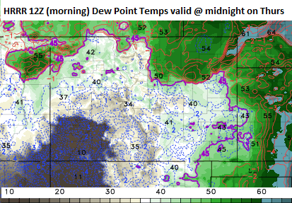
The site for the GEFS plumes is currently down, and with no fix in sight, I had to get a little creative today. Below is the 12Z (or morning) run of the HRRR showing dew points over Colorado at midnight tonight. The first thing you should notice is the very dry air mass over the southwest corner and the very moist air mass over the northern border/eastern Colorado. The reason for the high moisture over eastern Colorado is the cold front dropping south. Dew points behind the front increase 10-15F! While there may be a little drying at the mid-levels along the Urban Corridor throughout the day on Friday with weak westerly flow aloft, it remains quite moist over the eastern plains. This will translate into very efficient rain rates with moderate steering flows for storms; thus, an Elevated flood threat is issued. Unfortunately, the dry air over southwestern Colorado will remain intact and confine scattered, afternoon storms to the mountains and elevated terrains over the Grand Valley, Northwest Slope, Northern Mountains and Central Mountains.
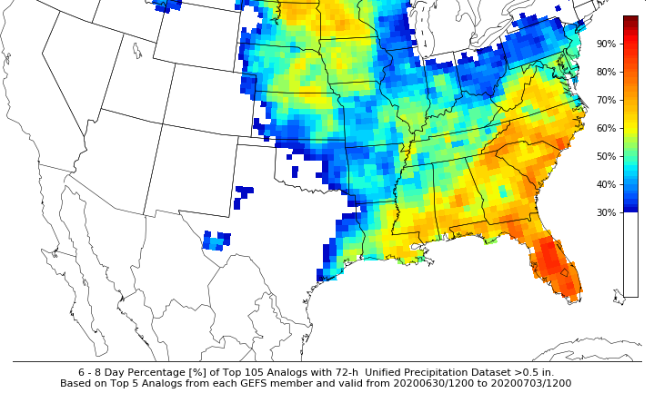
For a look at Event #2, the GEFS 6-8 day (valid Tuesday, Wednesday, and Thursday) chance of precipitation > 0.50 inches was pulled. While there may be some issues with topography due to the coarse resolution of the model, outside of the northeast corner of the state, chances of accumulations greater than 0.50 inches are less than 30% over this period. This just illustrates that there will not be much moisture associated with Event #2, and the main hazard will be critical fire weather for Colorado – especially western Colorado.
Event #1: Friday (6/26) – Sunday (6/28)
Elevated Threat/No Apparent Threat as a cutoff vorticity max brings extra mid-level energy to a moist air mass over eastern Colorado.
Friday should have more organized thunderstorms when compared to the last couple of days. A couple of these could become severe over the eastern plains with heavy rainfall, large hail (>1.25 in), and wind gusts (60 mph) possible. The wind threat will increase as storms become more of a MCS/bow echo over the plains. Outflow boundaries will help trigger additional convection for more widespread coverage as they move off the mountains by early afternoon. Storms are expected to cross into Kansas and Nebraska around midnight.
On Saturday, residual moisture may cause some storms to form over the Central, Northern and Front Range Mountains. With storm motion from the southwest to northeast, storms should spread into the Urban Corridor, Palmer Ridge, and Northeast Plains. With drier low levels the main threat will be gusty outflow winds and moderate rainfall. Even fewer storms are anticipated to form over the mountains on Sunday.
Event #2: Tuesday – Wednesday (6/30 – 7/1)
No Apparent Threat as the closed Low lifts northwards out of the state.
As mentioned above, the main threat will be fire danger for Event #2 over Colorado. Rain will likely return to the northern portion of the state for one of these days, but little to no accumulation is forecast. The image below just shows the area that will likely receive a little precipitation, but I have very low confidence that totals will reach 0.50 inches with the dry and abnormally strong system. Storms will also be moving quickly with the jet overhead, which will help to reduce totals. Expecting temperatures to reach near the triple digits on Sunday afternoon over the far eastern plains. So be sure to get in your afternoon activities on Saturday.