Issue Date: Monday, June 29th, 2020
Issue Time: 1:20PM MDT
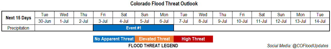
Valid Dates: 6/30 – 7/14
High fire danger will continue on Tuesday as the Low remains to our west and mixes high wind speeds down to the surface. The main difference from today is that it will be cooler across the state due to a cold front moving through overnight. Not much low-level moisture is associated with the front, and it quickly mixes out tomorrow, so wetting rainfall is not forecast for Tuesday. Outside of some very light rainfall over the northwest corner, it should remain dry. The Low will begin to lift northward and a ridge will build from east to west across the state the rest of the week. So enjoy the cool tomorrow as it won’t last for more than a day or so. By Friday, Event #1 begins as the High becomes centered over the desert southwest. This will start to pull higher moisture northward and move weak disturbances across the state (dirty ridge). The ridge becomes dislodged and begins to move east by early next week as the next trough approaches from the west. Thus, rainfall chances should start to decrease.
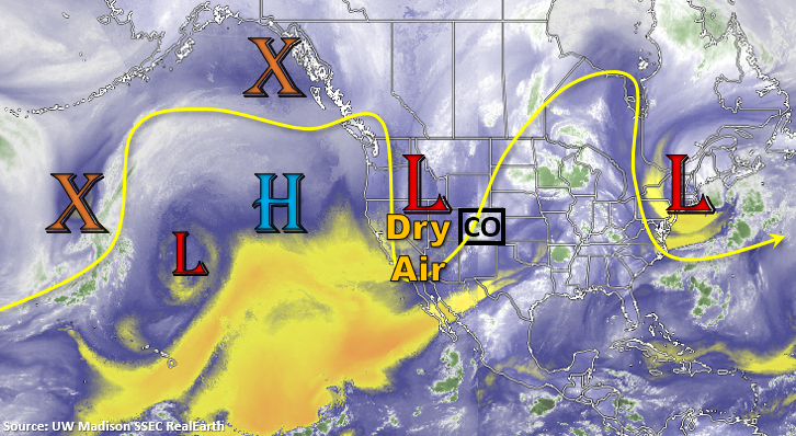
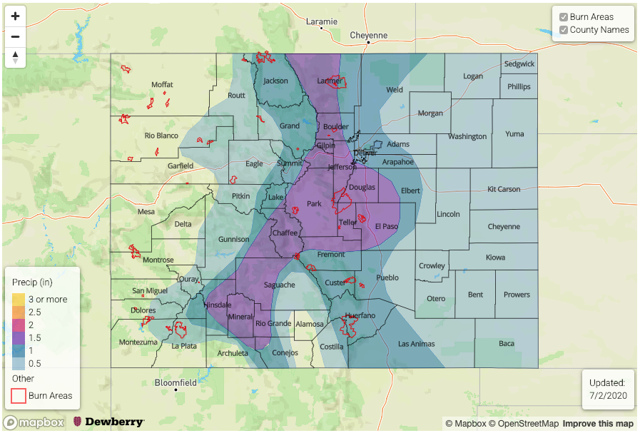
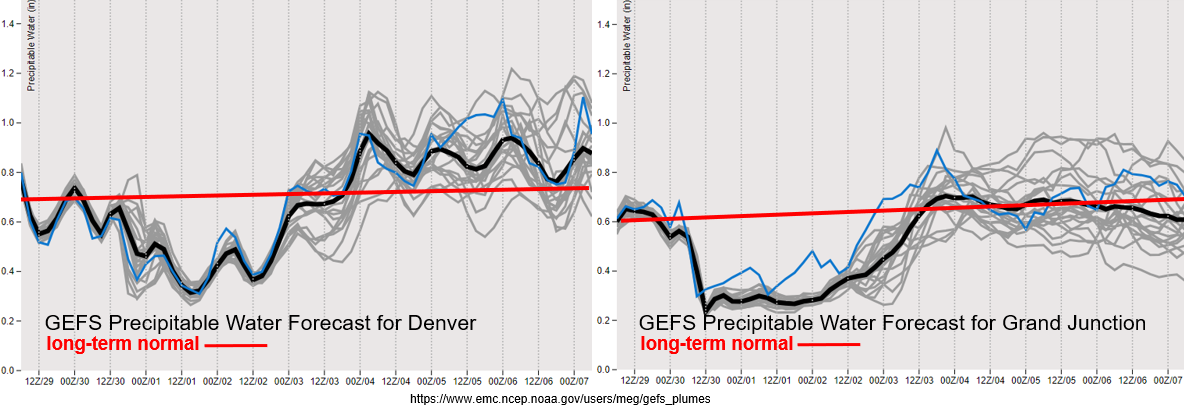
As far as moisture, the GEFS shows it really starting to drop off after today both east and west as the southwest flow aloft entrains a very dry air mass. Values over western Colorado are near record low values, so very high fire danger is anticipated on Tuesday. Tune into your local NWS office for the latest on Red Flag Warnings. The uptick in moisture associated with the building High can be seen later this week as well. We’ll watch how much moisture moves northward across the southern border over this week, but at this time there is No Apparent Threat. If the PW values are on the higher end of the GEFS solutions below, it is likely that on Friday or Saturday an Elevated Threat will be issued. Please tune back in on Thursday for the latest as details will likely change. We’ll also be able to better place an Elevated flood threat for recent burn areas this weekend. Nevertheless, slower steering winds under the ridge later this week will allow storms to drop beneficial, wetting rainfall.
Event #1: Friday (7/3) – Monday (7/6)
No Apparent Threat as the High sets up over the Desert Southwest and advects subtropical moisture northward.
It’s going to be hot this week with the 5880m marker moving north of the state by Thursday. The aforementioned uptick in moisture should bring storms back into the forecast by late this week. Weaker showers on Thursday will likely help moisten the boundary layer, which will allow more substantial rain to fall on Friday/into the weekend. Without much steering flow at the upper levels, storms should mostly stay confined to the mountains and immediate adjacent plains. This will also help accumulate rainfall over certain areas. At this time, the best chance for widespread showers and thunderstorms will be on Sunday, but a lot of details can change over the next few days. Tune back into the FTO on Thursday for the latest. Lastly, I just want to quickly mention there is an Elevated flood threat for Event #1 over recent burn areas due to the slower steering winds aloft. I only mention that now due to the holiday weekend and the increase in mountain recreation. It’s a bit too far to say much more than that due to low confidence in the details.