FTO 07-20-2020: Rainfall Threat Returns to Eastern Colorado Before Shifting to the West/Mountains

Issue Date: Monday, July 20th, 2020
Issue Time: 3PM MDT
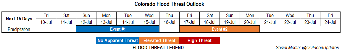
Valid Dates: 7/21– 8/4

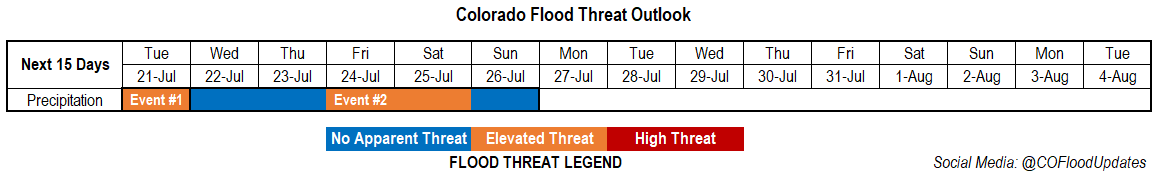
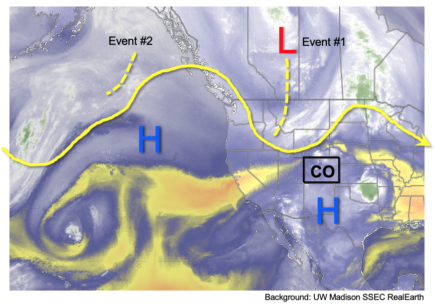
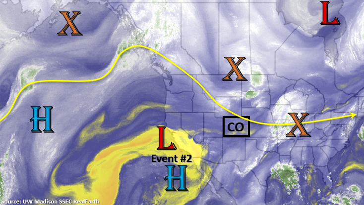
The unsettled weather pattern will continue this week, and an Elevated flood threat has been issued for Tuesday (Event #1). Another cool front/moist outflow boundary will push its way into eastern Colorado tomorrow morning, setting the stage for some local, heavy rainfall over the adjacent plains as storms move off the mountains. Additional heavy rainfall will be possible over the Northeast Plains as a shortwave passes through the northwesterly flow helping spark a severe thunderstorm or two.

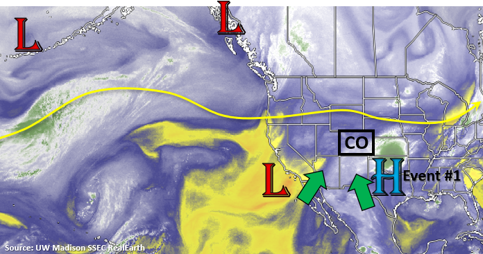
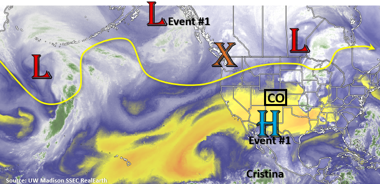
Event #2 begins on Wednesday, and the flood threat shifts back to western and southern Colorado. A cut-off low off the coast of California reinforces a PW surge with a building High to our southeast. The Low eventually looks to get absorbed (pulled to the northeast) by early this weekend, and then the ridge re-establishes itself over the central Plains. This will likely return heavy rainfall to the forecast by this weekend as a typical monsoon pattern takes hold.

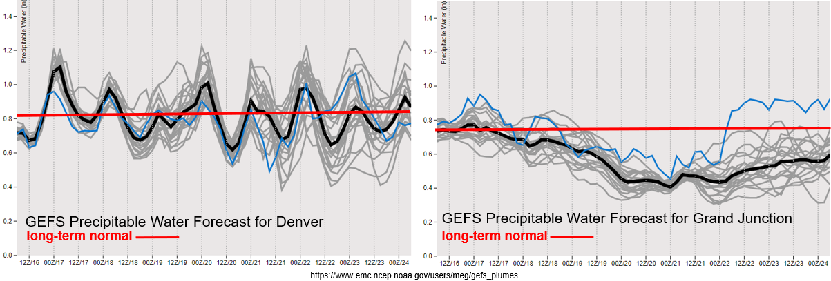
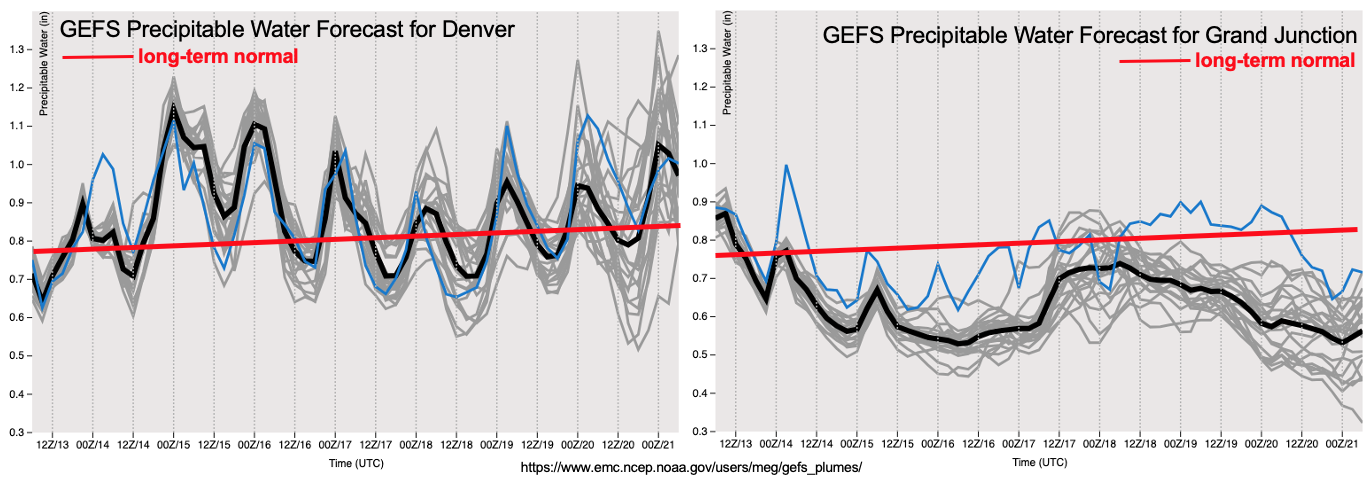
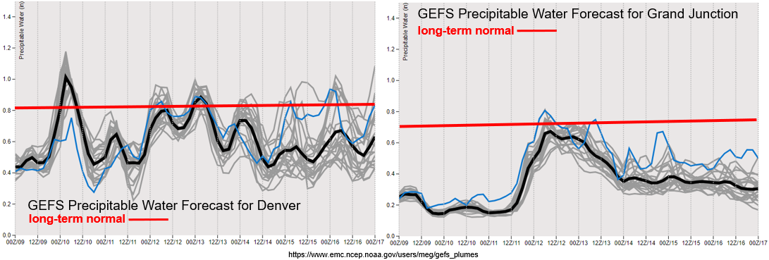
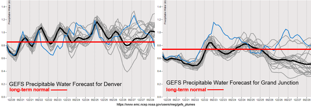
Elevated PW values near or above climatology should keep scattered storms in the forecast over the eastern mountains this week as seen by the GEFS plumes from Denver (left). On and off action over the adjacent plains should be expected with the best chance for storms further south along the Raton Ridge. Quite a bit of disagreement between members on PW values after Sunday, so low confidence in the forecast after this. Back to the west, there is a rapid rise in moisture as the Low moves inland on Wednesday. This will return moisture and rainfall to the forecast through this weekend. As this low is absorbed into the flow, extra mid-level energy is expected to help produce more widespread storms by the week’s end. Between this and slow steering winds under the building ridge, an Elevated flood threat has been issued.

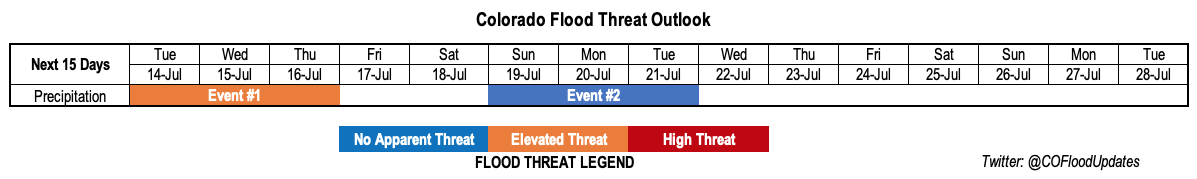
Event #1: Tuesday (7/21)

Elevated Threat as mid-level lift and low-level moisture combine over eastern Colorado.

Another one day Elevated flood threat for this event at the tail end of the current set up. A cold front/moist outflow boundary will push through the eastern plains on Tuesday morning. Expect some fog and cloud cover over the area to start the day. Low-level moisture will be a bit deeper, so this will help set the stage for some heavy rainfall. There are two areas of concern. One is over the Palmer Ridge, where slower steering flows will allow some heavier rainfall to accumulate. The second is over the Northeast Plains where a passing shortwave could help trigger a few severe thunderstorms. Large hail and strong, damaging wind gusts will be the main threats from the thunderstorms, but dew points in the 60Fs will allow for some very high rain rates. Tune into for the latest in tomorrow’s FTB.

Event #2: WednesdaySunday (7/22 – 7/26)

No Apparent/Elevated Threat as a PW surge returns showers and thunderstorms to western Colorado and the mountains.

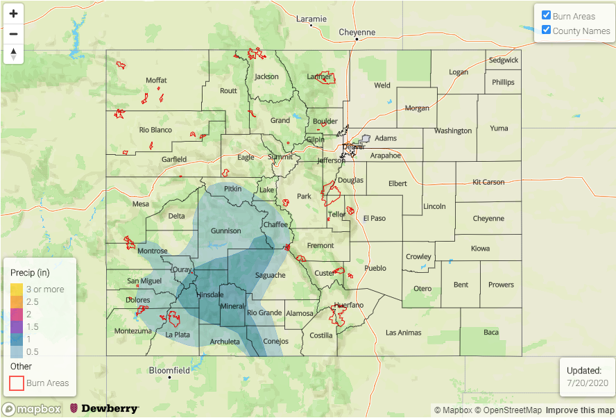
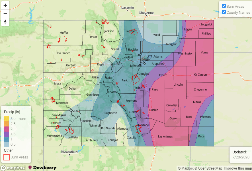
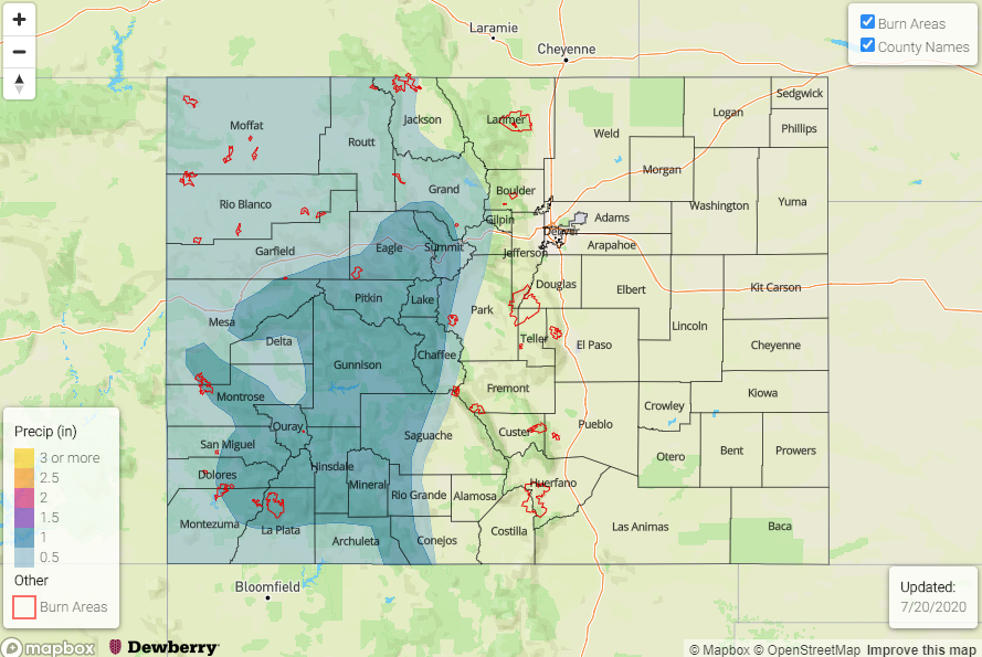
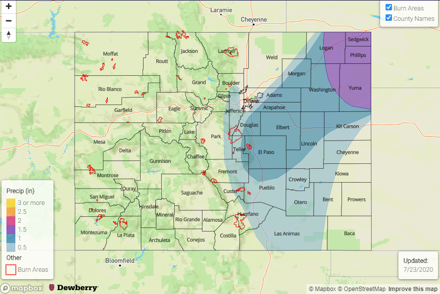
It’s going to be another active period for western Colorado and the mountains, which is good for the ongoing drought. There are some concerns with multiple days of rainfall and soils becoming saturated. This is especially true over the southern high terrains. Also concern for recent burn areas. Both will be monitored closely in each morning’s FTB. As waves move through the flow and combine with moisture, some days will likely have a higher flood threat than others. By this weekend, the pattern shifts to a more typical monsoon set up. This will likely keep showers in the forecast through the start of next week, but large spread in ensemble members means there is low confidence where the high will anchor by Monday.

FTO 07-16-2020: Daily Rounds of Rainfall Expected with a High Moisture Pattern

Issue Date: Thursday, July 16th, 2020
Issue Time: 2:40PM MDT
Valid Dates: 7/17– 7/31

One more day of an Elevated threat as high moisture and mid-level energy will move northward across the southern border. More rainfall is anticipated over the San Juan Mountains, and with decent accumulations expected today, partially saturated soils could cause issues for the 416 burn area. There will be a downtick in activity on Saturday, although isolated storms will likely still fire with residual moisture over the state. Not much of a break before Event #2 begins on Sunday when the flow aloft turns more northwesterly. This will push a couple cold fronts through the state at the beginning of the week. While cooling will be minimal over eastern Colorado (but still welcomed), this will keep low-level moisture on the higher end and may provide better dynamics for some stronger thunderstorms.

By Thursday, the ridge will begin to build back overhead, so there will likely be a decrease in the chance for rainfall. The drying trend doesn’t look like it will last long as the next incoming low will likely displace this ridge eastward. This should return rainfall to the forecast for the weekend. All in all, it’s going to be an active period, but that’s what one should expect during monsoon season. Hopefully this active pattern can start to help alleviate the drought conditions. More on that below.

As is well-known, PW values are heightened during this time of year. For the Denver PW values to remain at or above climatology, and with little spread between members through Thursday, it is shaping up to be an active week. Additionally, upper level dynamics under the northwest flow regime could help enhance thunderstorm coverage and strength. The details will lie in the timing of the passage of the fronts, which is still a bit too hard to determine this far out. However, there are enough ingredients for a heavy rainfall event, so an Elevated flood threat has been issued for Event #2.

Over eastern Colorado, there is a nice Low off the coast of California that is helping reinforce the PW surge over the state. This will continue to maintain itself through tomorrow, which is one of the reasons the Elevated flood threat has been issued (San Juan Mountains/416). By Saturday the Low begins to move east before being entrained into the westerly flow. With moisture really starting to drop off after Sunday, rainfall chances over western Colorado decrease to start the work week. Still quite a bit of spread in PW values after Tuesday, but this makes sense as the ridge begins to build and the exact placement of its axis is unknown.

The new drought map was released today (valid as of Tuesday). Thought it has been hot and dry? It sure has. Less than 5% of the state remains in the “None” classification, which is a stark contrast to 100% one year ago. The areas that are not classified as in a drought are over northern Front Range and far Northwest Corner. The D2 to D3 percentage area increased about 3%, and the None to D0 jumped the most at 5%. Hopefully we’ll be able to get some decent rainfall out of this active pattern coming up. I also took a quick glance at reservoir levels (not shown). Statewide, there was a drop from about 100% of usable storage at the end of may to ~85% at the end of June. I anticipated a large drop in the July statewide average after the recent heatwave and prolong period of little to no rainfall.

Event #1: Friday (7/16)

Elevated Threat with more day of enhanced mid-level lift and moisture move over the San Juan Mountains.

Quick one day Elevated flood threat for this event. One-inch rainfall accumulations will be possible over the San Juan Mountains today. With a “rinse and repeat” pattern anticipated tomorrow, there will likely be an increase in runoff. This is especially true over the 416 burn area (provided it gets a good wetting today), so another day of heavy rainfall could cause issues over the burn area such as mud flows and debris slides. Additionally, if heavy rain falls over the same area as today, there will be an increased chance of debris slides over the steeper slopes. Models are showing a bit better CAPE as well tomorrow afternoon over the southern San Juans, so higher rate rate intensities will be possible if clouds can clear out to let some instability build. Be sure to tune into the FTB tomorrow for the latest on the flood threat.

Event #2: SundayWednesday (7/19 – 7/22)

Elevated Threat as a series of cold front helps keep low-level moisture high over eastern Colorado.

During this period a couple cold fronts will drop through eastern Colorado. Paired with on and off lee troughing and decent shear, some severe weather may be possible as well. This is all of course dependent on the timing of the frontal passage, but the ingredients will be in place for storms to drop some heavy rainfall. Thus, the Elevated flood threat to start the week. This will mostly be an eastern Colorado event, although afternoon storms over the mountains may cause on and off issues for recent burn areas over the Southeast Mountains. Be sure to tune into the FTO on Monday for the latest.

Event #3 Friday – Saturday (7/24 – 7/26)

No Apparent Threat as we look at a potential rainfall event for western Colorado.

It’s always a bit of a struggle as to whether or not to mention events this far out. Especially, when there could be some beneficial rainfall for western Colorado in this drought. With a strong ridge building overhead, a nice PW plume will likely develop on the west side of the high again. As the ridge shifts, this could bring rainfall chances back to western Colorado. Typically, western Colorado’s main monsoon season is August, not July, so timing of this type of event matches up. We’ll keep our eye on this event as the details will inevitably evolve. Be sure to tune back into the FTO on Monday for an update.

FTO 07-13-2020: Periods of Increased Rainfall Amidst Continued Heat

Issue Date: Monday, July 13th, 2020
Issue Time: 1:15PM MDT
Valid Dates: 7/14-7/28

After enduring a very hot stretch of weather over the past week, relief is finally on its way for most of Colorado. As shown below, 7-day average temperatures were up to 8 degrees F above their normal for this time of year over parts of eastern Colorado, with the vast majority of the state seeing at least some degree of above normal heat.

Unfortunately, this relief of cooler weather will be quite temporary. It is being provided by the passage of a Pacific-origin cool front from the north, courtesy of a large-scale trough of low pressure over western Canada (see water vapor image, below). However, the stubborn ridge of high pressure that has been anchored to our south, will continue to maintain its strength. Thus, long-range guidance is in relatively good agreement on the placement of higher than normal upper-level heights to our east, which will continue to support above average heat for most of the state. Expect temperatures to average about 3-5F above normal over the next two weeks, with several days likely standing out from the rest, in sync with the strength of the upper-level ridge.

Fortunately, as shown in the PW plumes from the GFS Ensembles, below, there will be enough residual moisture to support at least scattered, diurnal bouts showers and thunderstorms almost every day. Two Events will likely lead to more organized activity during their 48-72 hour periods. The first event will start today and continue through Thursday, with at least a low-grade Elevated flood threat east of the Continental Divide. The second Event will begin late this weekend and into early next week, as another cool front passage is anticipated east of the Continental Divide. Unfortunately, as seen in the PW plumes, there will be a striking gradient in moisture between eastern and western Colorado, with far less rainfall expected west of the Continental Divide (especially Grand Valley and northward). Furthermore, at this time, the monsoon will remain generally subdued as the position of the high pressure ridge almost directly over Colorado is not conducive for moisture transport from the Gulf of California. Thus, we will need to rely on residual moisture as well as moisture from cool front passages originating from the north as our main precipitation sources.

Below, the two precipitation events are outlined in greater detail.

Event #1: Tuesday – Thursday (July 14 – July 16)

A low-grade Elevated flood threat along with severe weather; beneficial rainfall for San Juan Mountains

Precipitable water is expected to be in the 1.0 – 1.5 inch range over eastern Colorado through Thursday, which will lead to daily rounds of showers and thunderstorms along and east of the Continental Divide. The main area of concern will be eastern areas along the NE and KS borders, where storms are expected to organize into clusters and 3-hour rainfall could approach 2.5 inches locally. Along with the heavy rainfall will be a chance for severe weather, specifically large hail, as cloud-layer shear will remain above 30 mph through Thursday.

At this time, the higher-elevation (roughly 6,000 feet and above) rainfall intensity does not appear high enough for a flood threat. However, a small-scale plume of monsoon moisture is expected to increase rainfall coverage over the San Juan Mountains on Thursday. Total 3-day rainfall could approach 1.5 inches for favored south facing peaks, and should provide a welcome sight to the drought-stricken area of southwest Colorado. The only area of concern at this time is the 416 fire burn area, where repeated rounds of even brief heavy rainfall could elevate the landslide and mudflow concern by Thursday afternoon.

Unfortunately, the Grand Valley and Northwest Slope are expected to largely miss out on this rainfall.

Event #2: Sunday – Tuesday (July 19 – July 21)

No Apparent flood threat at this time, but this could change

After a short lull following Event #1, it is again eastern Colorado that could benefit from the passage of another cool front from the northwest by Sunday afternoon. The amount of moisture is not certain at this time, but it is likely to be enough for scattered shower and storm activity mainly east of the Continental Divide and in the San Juan Mountains. At this time 3-day totals of up to 1.5 inches, locally, are possible in the Northeast Plains. Up to 1.0 inch of rainfall appears possible especially in favored areas of the Palmer Ridge and San Juan Mountains.

FTO 07-09-2020: Heat Wave Continues & Storms Return to Start Next Week

Issue Date: Thursday, July 9th, 2020
Issue Time: 3PM MDT
Valid Dates: 7/10– 7/24

One can safely say that the models did really well predicting this week’s heat wave a little over a week out. Highs each afternoon have been up to about 10F above normal, and will continue to stay that way for the near future. Other than a couple storms over the Northeast Plains this afternoon, it should continue to stay dry. Scattered storms are expected to return this weekend beginning on Sunday as the ridge to our south is displaced eastward with an incoming Low and lee troughing occurs each afternoon. For the most part, it looks like the measurable rain will stick to the eastern plains, but weak scattered storms may be possible over the mountains at the beginning of the work week. So Event #1 will have No Apparent flood threat.

There will likely be a break in rainfall sometime mid-week as flow briefly becomes more zonal and mixes out remaining surface moisture with downsloping winds. However, long-rang models are showing a strong ridge quickly building to our east. If this ridge is able to set up in the right place, there is a chance for a strong PW surge across the state. Fingers crossed that this moisture surge, from both the Gulf of Mexico and Gulf of California, occurs and sets up a temporary monsoon pattern. This week’s warm temperatures and dry afternoons are definitely not improving our drought situation.

It’s still quite dry over western Colorado with PW values near the 10th percentile, which will keep fire danger high over the next couple of days despite lower surface wind speeds. The GEFS shows good consensus with the next moisture surge beginning Saturday morning. Still not quite enough moisture for a lot of wetting rainfall, and the dry boundary layer will likely also inhibit moderate accumulations; however, some scattered weak storms may be possible along and near the higher peaks of the San Juan and Central Mountains. Winds aloft (and at the surface) are expected pick up during the zonal flow period from Tuesday into Wednesday, and with PW beginning to drop off after Sunday night. This will likely translate to Elevated fire danger next week.

Over eastern Colorado, the weak moisture surge will return PW values closer to climatology. Thus, there may be some high-based storms over the mountains to start the work week. PW values look a little better over the eastern plains early next week due to surface lows developing in the afternoons. Thus, the best chance for wetting rainfall will be along the eastern border and over the Raton Ridge due to its position further south.

Event #1: Sunday Wednesday (7/12 7/15)

No Apparent Threat as lee troughs pull moisture over the eastern border, and a slight shift in the ridge axis increases moisture over the mountains.

Flooding is not anticipated this weekend into next week even though scattered storms return to the forecast. Not much measurable rain is anticipated over the mountains, western Colorado, or the adjacent plains, but the extra afternoon/evening cloud cover will be some nice relief from the heat. The near normal PW values are short-lived over western Colorado, and some dry thunderstorms Sunday into Monday may pose a fire threat. Fire danger will likely increase at the start of next week under the zonal flow pattern, which will dry out the atmosphere and help increase surface winds. Be sure to follow your local NWS office and check back into Monday’s FTO for the latest information.

Highest chance for wetting rainfall and a few thunderstorms early next week will be over the Northeast Plains. There should be better moisture in this area from the lee troughing and passing cold fronts/outflow boundaries, which should allow some higher instabilities to build. Additionally, rainfall will be possible along the southern Raton Ridge due to its vicinity of higher moisture (south) and passing (weak) shortwaves around the High. The flood threat looks low, but some decent (welcome) rainfall will still be possible.

Event #2: Friday Monday (7/17 – 7/20)

Elevated Threat as we look at our first (short-lived) monsoon moisture surge.

It’s a bit too far out to get too excited, but with the potential ridging pattern to our east, we could get a nice PW surge from the south across the state. Of course, this all depends where the ridge sets up and how long it sits in place. These sorts of details will likely evolve and change as the event nears. However, the last few long-term model runs are pointing to the start of a (temporary) monsoon pattern, so it’s worth mentioning. As far as the typical start date for the monsoon, we have arrived to the highest PW values of the year. So, the onset is already expected to be slightly delayed from normal. Don’t put too much emphasis on the map below as the details will change.