Issue Date: Thursday, July 16th, 2020
Issue Time: 2:40PM MDT
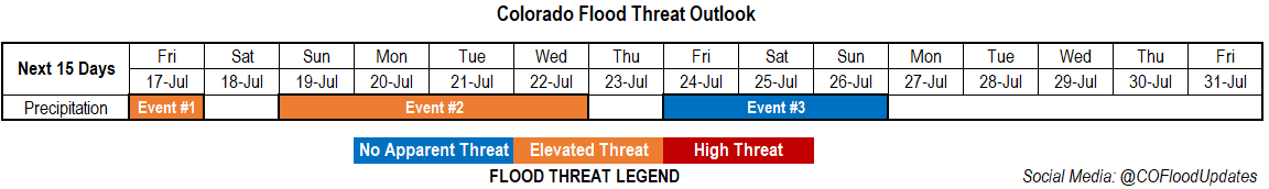
Valid Dates: 7/17– 7/31
One more day of an Elevated threat as high moisture and mid-level energy will move northward across the southern border. More rainfall is anticipated over the San Juan Mountains, and with decent accumulations expected today, partially saturated soils could cause issues for the 416 burn area. There will be a downtick in activity on Saturday, although isolated storms will likely still fire with residual moisture over the state. Not much of a break before Event #2 begins on Sunday when the flow aloft turns more northwesterly. This will push a couple cold fronts through the state at the beginning of the week. While cooling will be minimal over eastern Colorado (but still welcomed), this will keep low-level moisture on the higher end and may provide better dynamics for some stronger thunderstorms.
By Thursday, the ridge will begin to build back overhead, so there will likely be a decrease in the chance for rainfall. The drying trend doesn’t look like it will last long as the next incoming low will likely displace this ridge eastward. This should return rainfall to the forecast for the weekend. All in all, it’s going to be an active period, but that’s what one should expect during monsoon season. Hopefully this active pattern can start to help alleviate the drought conditions. More on that below.
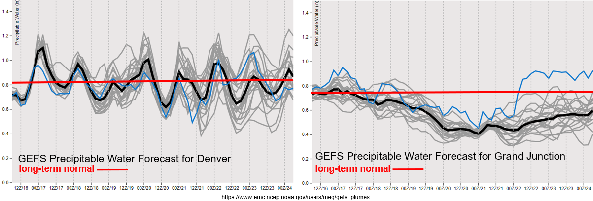
As is well-known, PW values are heightened during this time of year. For the Denver PW values to remain at or above climatology, and with little spread between members through Thursday, it is shaping up to be an active week. Additionally, upper level dynamics under the northwest flow regime could help enhance thunderstorm coverage and strength. The details will lie in the timing of the passage of the fronts, which is still a bit too hard to determine this far out. However, there are enough ingredients for a heavy rainfall event, so an Elevated flood threat has been issued for Event #2.
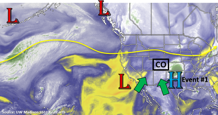
Over eastern Colorado, there is a nice Low off the coast of California that is helping reinforce the PW surge over the state. This will continue to maintain itself through tomorrow, which is one of the reasons the Elevated flood threat has been issued (San Juan Mountains/416). By Saturday the Low begins to move east before being entrained into the westerly flow. With moisture really starting to drop off after Sunday, rainfall chances over western Colorado decrease to start the work week. Still quite a bit of spread in PW values after Tuesday, but this makes sense as the ridge begins to build and the exact placement of its axis is unknown.
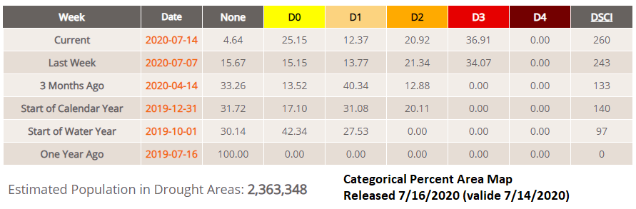
The new drought map was released today (valid as of Tuesday). Thought it has been hot and dry? It sure has. Less than 5% of the state remains in the “None” classification, which is a stark contrast to 100% one year ago. The areas that are not classified as in a drought are over northern Front Range and far Northwest Corner. The D2 to D3 percentage area increased about 3%, and the None to D0 jumped the most at 5%. Hopefully we’ll be able to get some decent rainfall out of this active pattern coming up. I also took a quick glance at reservoir levels (not shown). Statewide, there was a drop from about 100% of usable storage at the end of may to ~85% at the end of June. I anticipated a large drop in the July statewide average after the recent heatwave and prolong period of little to no rainfall.
Event #1: Friday (7/16)
Elevated Threat with more day of enhanced mid-level lift and moisture move over the San Juan Mountains.
Quick one day Elevated flood threat for this event. One-inch rainfall accumulations will be possible over the San Juan Mountains today. With a “rinse and repeat” pattern anticipated tomorrow, there will likely be an increase in runoff. This is especially true over the 416 burn area (provided it gets a good wetting today), so another day of heavy rainfall could cause issues over the burn area such as mud flows and debris slides. Additionally, if heavy rain falls over the same area as today, there will be an increased chance of debris slides over the steeper slopes. Models are showing a bit better CAPE as well tomorrow afternoon over the southern San Juans, so higher rate rate intensities will be possible if clouds can clear out to let some instability build. Be sure to tune into the FTB tomorrow for the latest on the flood threat.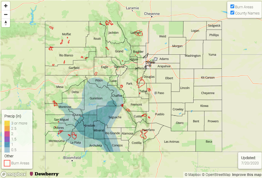
Event #2: Sunday – Wednesday (7/19 – 7/22)
Elevated Threat as a series of cold front helps keep low-level moisture high over eastern Colorado.
During this period a couple cold fronts will drop through eastern Colorado. Paired with on and off lee troughing and decent shear, some severe weather may be possible as well. This is all of course dependent on the timing of the frontal passage, but the ingredients will be in place for storms to drop some heavy rainfall. Thus, the Elevated flood threat to start the week. This will mostly be an eastern Colorado event, although afternoon storms over the mountains may cause on and off issues for recent burn areas over the Southeast Mountains. Be sure to tune into the FTO on Monday for the latest.
Event #3 Friday – Saturday (7/24 – 7/26)
No Apparent Threat as we look at a potential rainfall event for western Colorado.
It’s always a bit of a struggle as to whether or not to mention events this far out. Especially, when there could be some beneficial rainfall for western Colorado in this drought. With a strong ridge building overhead, a nice PW plume will likely develop on the west side of the high again. As the ridge shifts, this could bring rainfall chances back to western Colorado. Typically, western Colorado’s main monsoon season is August, not July, so timing of this type of event matches up. We’ll keep our eye on this event as the details will inevitably evolve. Be sure to tune back into the FTO on Monday for an update.