Issue Date: Monday, July 13th, 2020
Issue Time: 1:15PM MDT
Valid Dates: 7/14-7/28
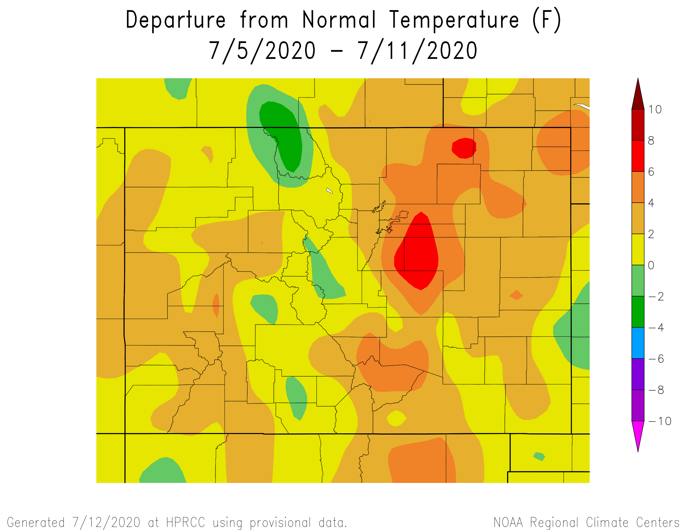
After enduring a very hot stretch of weather over the past week, relief is finally on its way for most of Colorado. As shown below, 7-day average temperatures were up to 8 degrees F above their normal for this time of year over parts of eastern Colorado, with the vast majority of the state seeing at least some degree of above normal heat.
Unfortunately, this relief of cooler weather will be quite temporary. It is being provided by the passage of a Pacific-origin cool front from the north, courtesy of a large-scale trough of low pressure over western Canada (see water vapor image, below). However, the stubborn ridge of high pressure that has been anchored to our south, will continue to maintain its strength. Thus, long-range guidance is in relatively good agreement on the placement of higher than normal upper-level heights to our east, which will continue to support above average heat for most of the state. Expect temperatures to average about 3-5F above normal over the next two weeks, with several days likely standing out from the rest, in sync with the strength of the upper-level ridge.
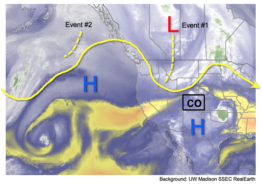
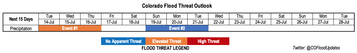
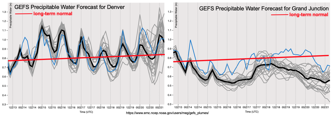
Fortunately, as shown in the PW plumes from the GFS Ensembles, below, there will be enough residual moisture to support at least scattered, diurnal bouts showers and thunderstorms almost every day. Two Events will likely lead to more organized activity during their 48-72 hour periods. The first event will start today and continue through Thursday, with at least a low-grade Elevated flood threat east of the Continental Divide. The second Event will begin late this weekend and into early next week, as another cool front passage is anticipated east of the Continental Divide. Unfortunately, as seen in the PW plumes, there will be a striking gradient in moisture between eastern and western Colorado, with far less rainfall expected west of the Continental Divide (especially Grand Valley and northward). Furthermore, at this time, the monsoon will remain generally subdued as the position of the high pressure ridge almost directly over Colorado is not conducive for moisture transport from the Gulf of California. Thus, we will need to rely on residual moisture as well as moisture from cool front passages originating from the north as our main precipitation sources.
Below, the two precipitation events are outlined in greater detail.
Event #1: Tuesday – Thursday (July 14 – July 16)
A low-grade Elevated flood threat along with severe weather; beneficial rainfall for San Juan Mountains
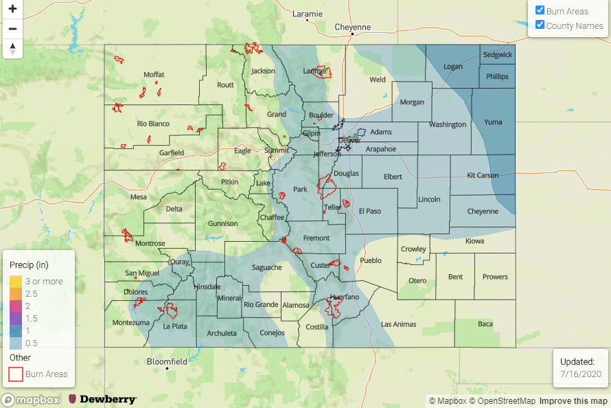
Precipitable water is expected to be in the 1.0 – 1.5 inch range over eastern Colorado through Thursday, which will lead to daily rounds of showers and thunderstorms along and east of the Continental Divide. The main area of concern will be eastern areas along the NE and KS borders, where storms are expected to organize into clusters and 3-hour rainfall could approach 2.5 inches locally. Along with the heavy rainfall will be a chance for severe weather, specifically large hail, as cloud-layer shear will remain above 30 mph through Thursday.
At this time, the higher-elevation (roughly 6,000 feet and above) rainfall intensity does not appear high enough for a flood threat. However, a small-scale plume of monsoon moisture is expected to increase rainfall coverage over the San Juan Mountains on Thursday. Total 3-day rainfall could approach 1.5 inches for favored south facing peaks, and should provide a welcome sight to the drought-stricken area of southwest Colorado. The only area of concern at this time is the 416 fire burn area, where repeated rounds of even brief heavy rainfall could elevate the landslide and mudflow concern by Thursday afternoon.
Unfortunately, the Grand Valley and Northwest Slope are expected to largely miss out on this rainfall.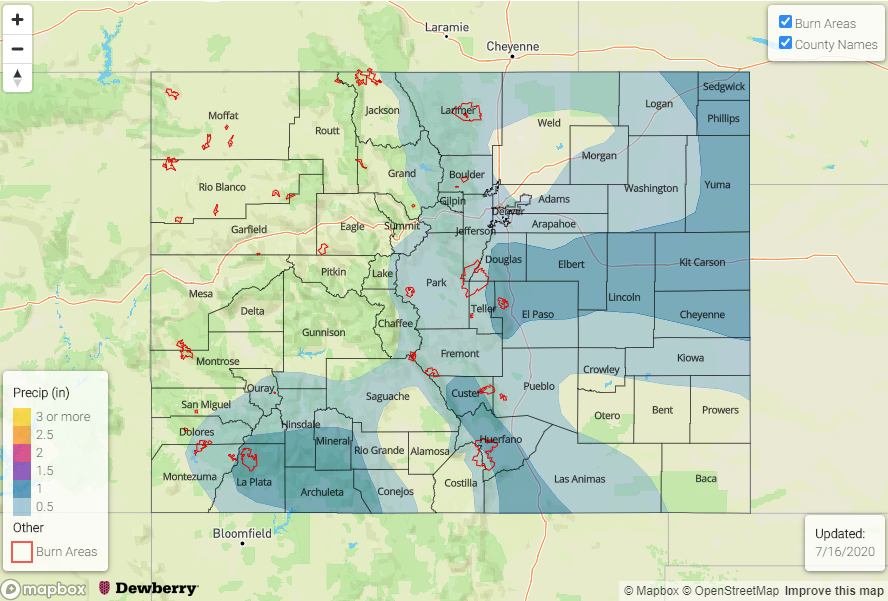
Event #2: Sunday – Tuesday (July 19 – July 21)
No Apparent flood threat at this time, but this could change
After a short lull following Event #1, it is again eastern Colorado that could benefit from the passage of another cool front from the northwest by Sunday afternoon. The amount of moisture is not certain at this time, but it is likely to be enough for scattered shower and storm activity mainly east of the Continental Divide and in the San Juan Mountains. At this time 3-day totals of up to 1.5 inches, locally, are possible in the Northeast Plains. Up to 1.0 inch of rainfall appears possible especially in favored areas of the Palmer Ridge and San Juan Mountains.