Issue Date: Thursday, July 9th, 2020
Issue Time: 3PM MDT
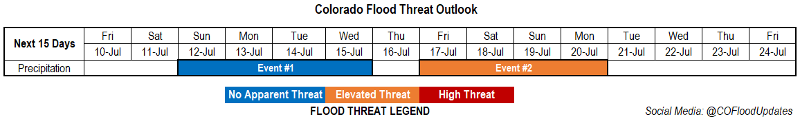
Valid Dates: 7/10– 7/24
One can safely say that the models did really well predicting this week’s heat wave a little over a week out. Highs each afternoon have been up to about 10F above normal, and will continue to stay that way for the near future. Other than a couple storms over the Northeast Plains this afternoon, it should continue to stay dry. Scattered storms are expected to return this weekend beginning on Sunday as the ridge to our south is displaced eastward with an incoming Low and lee troughing occurs each afternoon. For the most part, it looks like the measurable rain will stick to the eastern plains, but weak scattered storms may be possible over the mountains at the beginning of the work week. So Event #1 will have No Apparent flood threat.
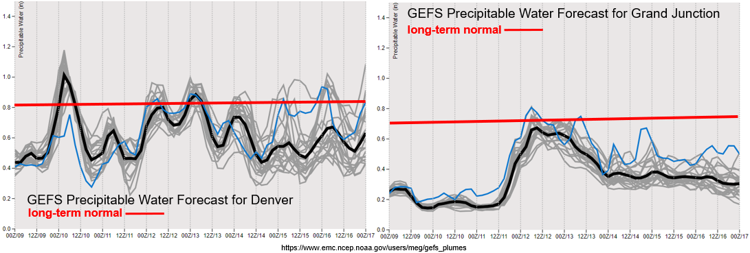
There will likely be a break in rainfall sometime mid-week as flow briefly becomes more zonal and mixes out remaining surface moisture with downsloping winds. However, long-rang models are showing a strong ridge quickly building to our east. If this ridge is able to set up in the right place, there is a chance for a strong PW surge across the state. Fingers crossed that this moisture surge, from both the Gulf of Mexico and Gulf of California, occurs and sets up a temporary monsoon pattern. This week’s warm temperatures and dry afternoons are definitely not improving our drought situation.
It’s still quite dry over western Colorado with PW values near the 10th percentile, which will keep fire danger high over the next couple of days despite lower surface wind speeds. The GEFS shows good consensus with the next moisture surge beginning Saturday morning. Still not quite enough moisture for a lot of wetting rainfall, and the dry boundary layer will likely also inhibit moderate accumulations; however, some scattered weak storms may be possible along and near the higher peaks of the San Juan and Central Mountains. Winds aloft (and at the surface) are expected pick up during the zonal flow period from Tuesday into Wednesday, and with PW beginning to drop off after Sunday night. This will likely translate to Elevated fire danger next week.
Over eastern Colorado, the weak moisture surge will return PW values closer to climatology. Thus, there may be some high-based storms over the mountains to start the work week. PW values look a little better over the eastern plains early next week due to surface lows developing in the afternoons. Thus, the best chance for wetting rainfall will be along the eastern border and over the Raton Ridge due to its position further south.
Event #1: Sunday – Wednesday (7/12 – 7/15)
No Apparent Threat as lee troughs pull moisture over the eastern border, and a slight shift in the ridge axis increases moisture over the mountains.
Flooding is not anticipated this weekend into next week even though scattered storms return to the forecast. Not much measurable rain is anticipated over the mountains, western Colorado, or the adjacent plains, but the extra afternoon/evening cloud cover will be some nice relief from the heat. The near normal PW values are short-lived over western Colorado, and some dry thunderstorms Sunday into Monday may pose a fire threat. Fire danger will likely increase at the start of next week under the zonal flow pattern, which will dry out the atmosphere and help increase surface winds. Be sure to follow your local NWS office and check back into Monday’s FTO for the latest information.
Highest chance for wetting rainfall and a few thunderstorms early next week will be over the Northeast Plains. There should be better moisture in this area from the lee troughing and passing cold fronts/outflow boundaries, which should allow some higher instabilities to build. Additionally, rainfall will be possible along the southern Raton Ridge due to its vicinity of higher moisture (south) and passing (weak) shortwaves around the High. The flood threat looks low, but some decent (welcome) rainfall will still be possible.
Event #2: Friday – Monday (7/17 – 7/20)
Elevated Threat as we look at our first (short-lived) monsoon moisture surge.
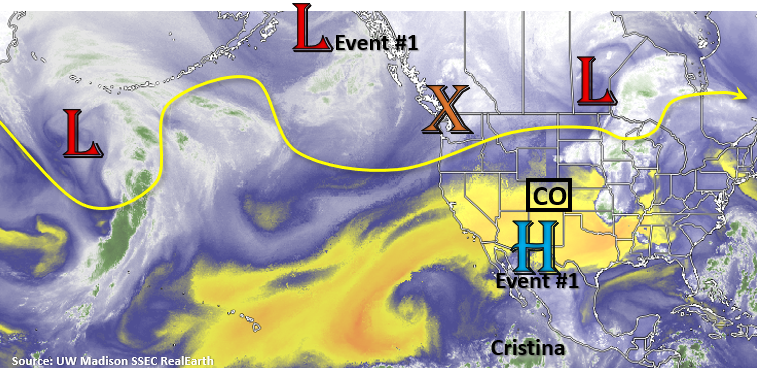
It’s a bit too far out to get too excited, but with the potential ridging pattern to our east, we could get a nice PW surge from the south across the state. Of course, this all depends where the ridge sets up and how long it sits in place. These sorts of details will likely evolve and change as the event nears. However, the last few long-term model runs are pointing to the start of a (temporary) monsoon pattern, so it’s worth mentioning. As far as the typical start date for the monsoon, we have arrived to the highest PW values of the year. So, the onset is already expected to be slightly delayed from normal. Don’t put too much emphasis on the map below as the details will change.