FTO 08-03-2020: High Flood Threat for Tuesday with Severe Storms Forecast for the Eastern Plains

Issue Date: Monday, August 3rd, 2020
Issue Time: 3PM MDT
Valid Dates: 8/4– 8/18

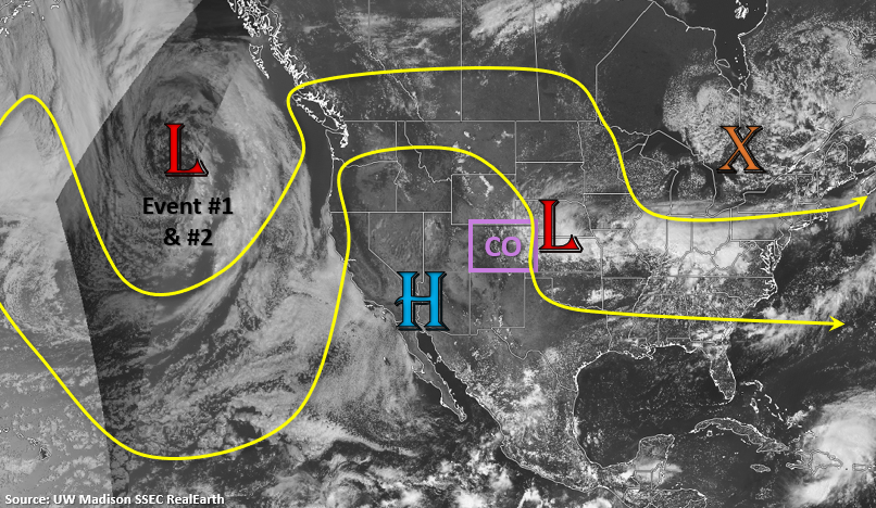
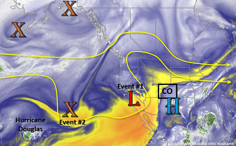
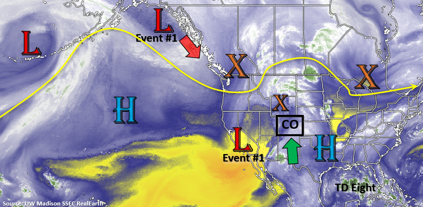
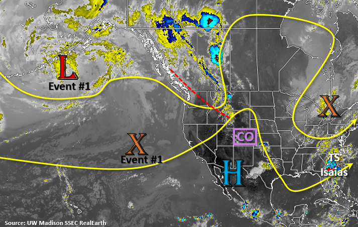
The shortwave to our north (red dashed line) will be well north and east of the state by tomorrow. It will be replaced by an incoming Low (Gulf of Alaska) and a minor upper trough (Event #1), which will help rebuild a weaker ridge over Colorado for the rest of this week. The ridging pattern from Wednesday into Friday will continue the setup we saw for this last event, dry to the west and moist to the east as disturbances move through the WNW flow. The flow should become more westerly tomorrow evening, rather than NW, as a stronger shortwave moves through the flow. This will help push storms further into the eastern plains where a lee cyclone will pull in some higher moisture. With another passing jet streak, some severe thunderstorms will be possible that could linger into the evening and overnight hours.

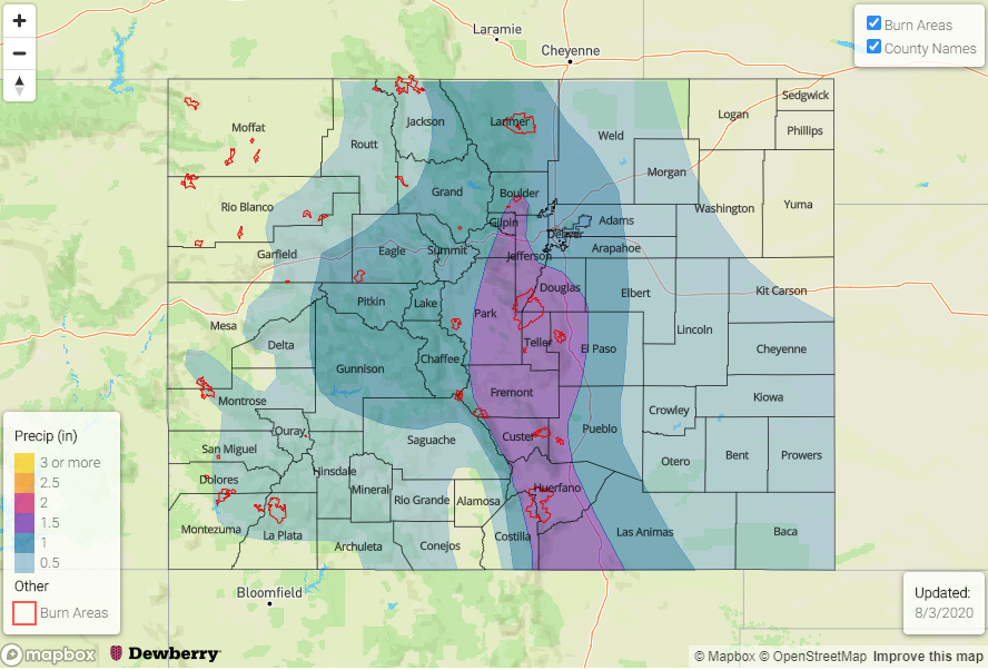
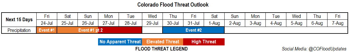
By Saturday, the ridge starts to strengthens to our south, which will cause a decrease in moisture over the state as southwesterly and westerly flow increases. While some weak showers will likely still be able to form over the mountains each afternoon with residual moisture, there should be quite the downtick in rainfall for the weekend. Starting next week, the weak ridge axis looks to be pushed slightly east, which will allow for some higher PW values to return to the state for Event #2. Some days will likely have a higher flood risk than others, but to pinpoint disturbances moving through the flow this far out is very difficult. So, at this time there is No Apparent Threat.

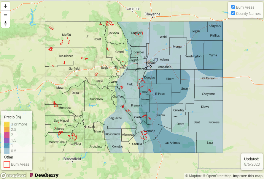
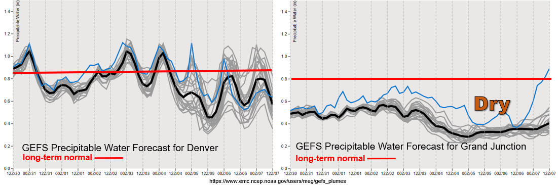
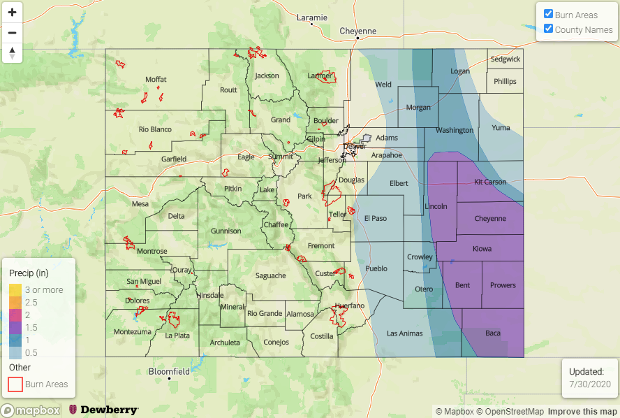
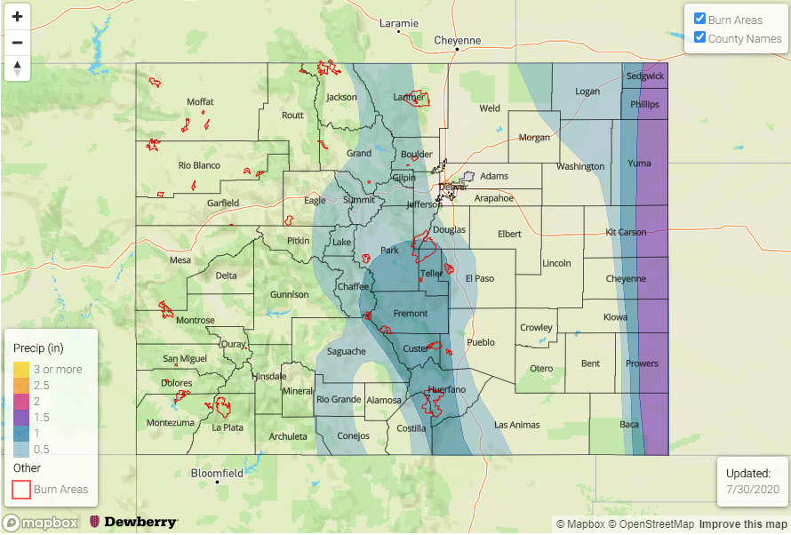
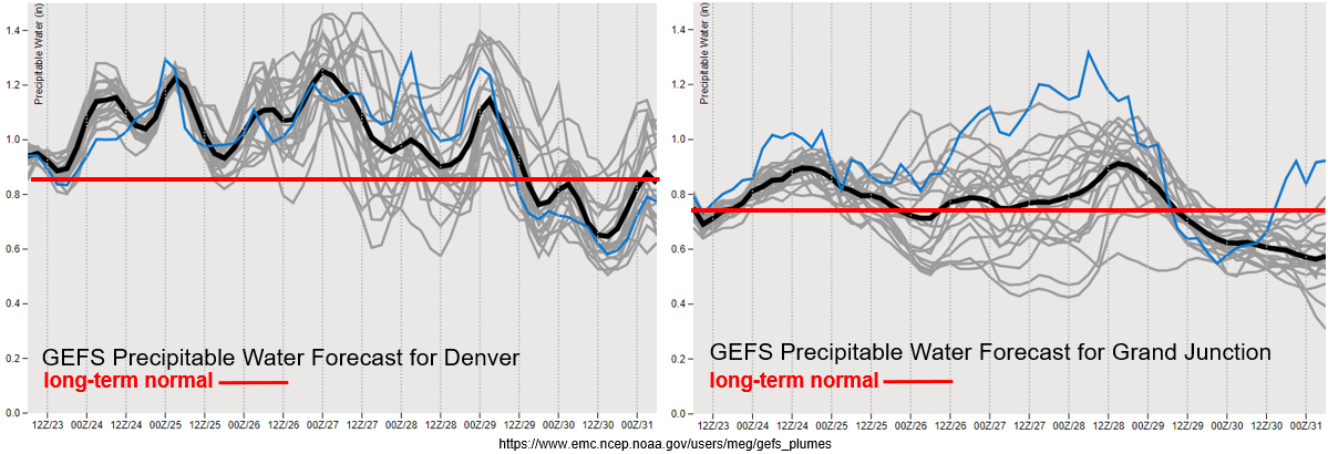
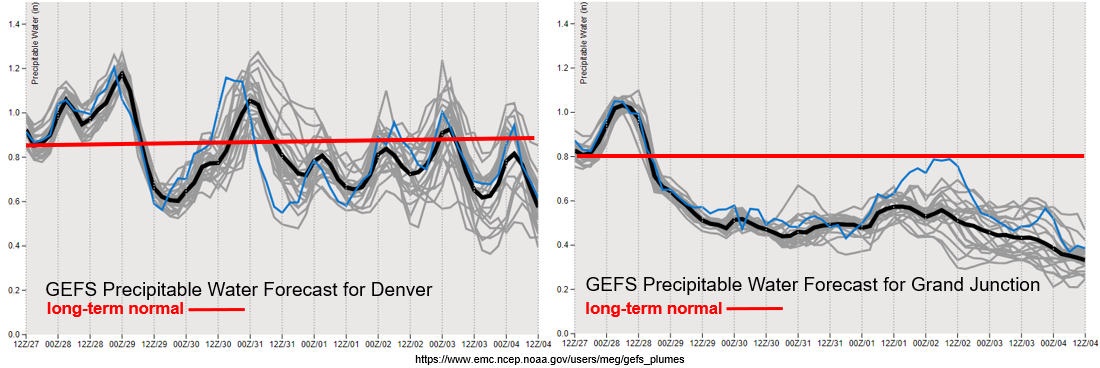
It’s the time of year when we start to see the decreasing trend in PW values on the backside of the monsoon. As seen in the last system, PW values continue to remain low over western Colorado and really drop off into this weekend. Thankfully, there are no days with strong upper flow mixing down to the surface, so critical fire weather is not anticipated. However, dry fuels are abundant and are really driving the Pine Gulch Fire. With the drought still in place over the majority of the state and a long, hot week ahead, elevated fire danger is forecast. Please use caution with any open flames or activities that could cause a spark, and pay attention to fire bans. The lone, heavy rainfall event last week did little to alleviate the ongoing drought.

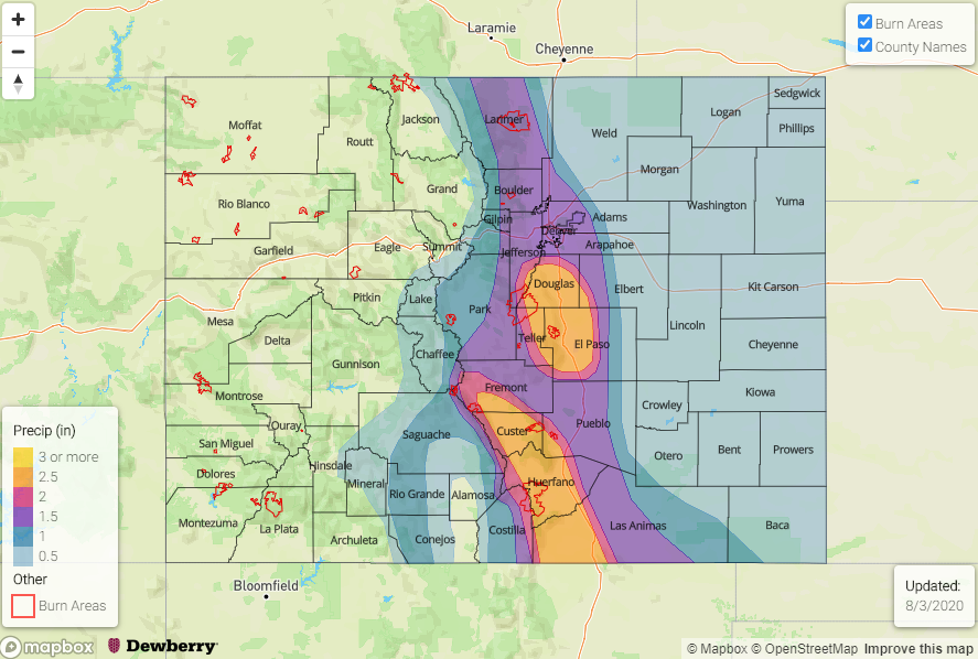
Over eastern Colorado, it looks like southeasterly and easterly flow at the surface really is helping keep the higher moisture pressed up against the foothills the next two days. Tomorrow, a lee cyclone is expected to develop over the eastern plains, which will continue to pull in high moisture on its east and north side, as well as enhance convergence, as seen by the PW values greater than inch at Denver.  Thus, an Elevated flood threat has been issued due to the increased moisture and upper dynamics combining over the eastern plains. An Elevated flood threat should suffice for Wednesday onward with a higher likelihood of storms moving into the adjacent plains/higher moisture environment with the more westerly flow aloft. The timing of shortwaves during this period will cause on and off flood threats this week over the plains.
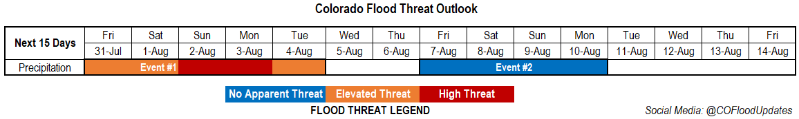
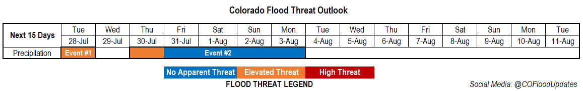
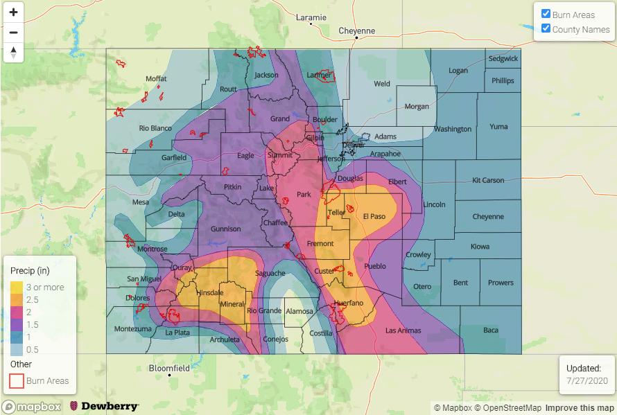
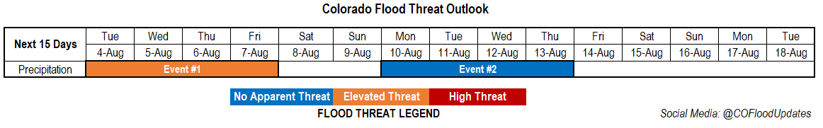
Event #1: Tuesday – Friday (8/4 8/7)

Elevated Threat as a lee cyclone and continued southeasterly/easterly flow at the surface holds higher moisture in place.

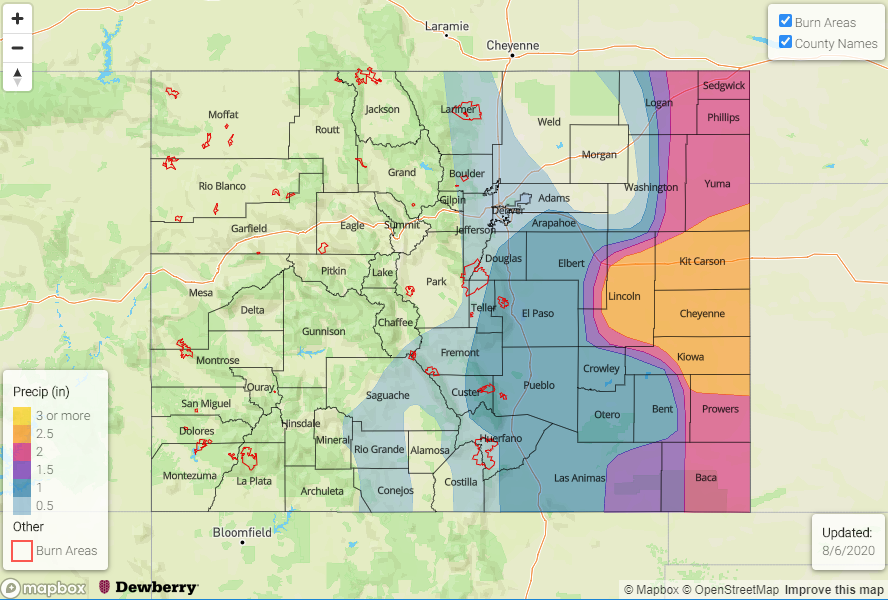
Looking at some more severe thunderstorms tomorrow over the eastern plains. Plenty of shear, moisture, and mid-level energy will combine to help create some large hail and damaging outflow winds. Best chance for storms will be over the far eastern plains where the lee cyclone will pull in the highest dew points. Even though storms will be moving relatively quickly with a jet streak aloft, they will still be able to produce rain rates just under 2 inches in an hour. Thus, a Moderate flood threat has been issued. For the rest of the week, disturbances will move through the flow and more WNW steering flow will help storms travel further in the plains where there is better moisture. Passing shortwaves and fronts/boundaries will likely create pockets of heavy rainfall over the plains. This event is less of a threat for recent burn areas when compared to this last event.
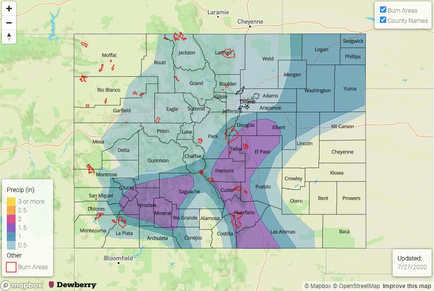
Event #2: MondayThursday (8/10 – 8/13)

No Apparent as a slight ridge shift allows some higher moisture to return to the area.

At this time, no thinking this event will have much of a flood threat. This is especially true over western Colorado where dry conditions in the boundary layer will cause storms to produce more wind/evaporation than rainfall after the moisture begins to return. There should be an uptick in activity over the southern/eastern San Juan Mountains for this event and other mountainous areas south. As flow becomes more northwesterly when the High rebuilds over the desert Southwest, more rainfall will be possible over eastern Colorado as disturbances help return the low-level moisture to the area.

FTO 07-30-2020: Heavy Rainfall Threat Returns to Eastern Colorado with an Increased Threat for Burn Areas over the Southeast Mountains

Issue Date: Thursday, July 30th, 2020
Issue Time: 4:45PM MDT
Valid Dates: 7/30– 8/14

The ridging pattern for this next event will keep western Colorado dry, but several disturbances are expected to move through the flow over eastern CO, which will return daily rounds of storms to the eastern mountains and adjacent plains. As always, the timing of these shortwaves is imperative to the rainfall threat, and are hard to track more than a day out. However, this is an anomalously strong Low system, so thinking there will be plenty of mid-level energy in this dirty ridge pattern for more widespread storms over the eastern mountains. Additionally, with the on and off moisture, storms could pose a threat to recent burn areas over the Southeast Mountains through the start of next week. The Low will push to northern Rockies/plains by early next week, which will help raise the flood threat for either Sunday and/or Monday over the eastern mountains and adjacent plains.

While daily rounds of showers will be possible each day next week, they should be more isolated by mid-week before a more traditional monsoon pattern starts to set up next weekend (Event #2). Moisture looks to return statewide with another cut off low/west coast trough helping syphon moisture into the state with the High located somewhere over the High Plains.

One word to describe the air mass over western Colorado through the end of next week: DRY. PW has quickly dropped off with the High over the Desert Southwest, which is pushing very dry air into the state with northwesterly flow. Thus, the chances of rainfall over the next week will be low. Not looking at any upper level jet features either, so at this time critical fire conditions are not anticipated.

Flipping back to the east – Colorado’s air masses often get nicely divided by the Continental Divide. Expect a break in heavy rainfall chances on Friday as dry air and subsidence fills in behind the departing upper trough. The Elevated flood threat has been issued for the Spring Creek burn area as storms activity in the area should be on the uptick when compared to today. Moisture is also on the rise and is quite elevated Sunday into Monday as the trough passes to our north. So, it is likely there will be a Moderate FTB threat issued on one or possibly both of those days, so a HIGH FTO threat is being issued. By Wednesday, expecting more isolated storm coverage over the mountains, but spread in the model members (gray lines) may cause these days to added back into the threat legend in Monday’s FTO.

Event #1: Friday Tuesday (7/31 8/4)

High/Elevated Threat as a strong Low will send disturbances through eastern Colorado, returning the flood threat to the eastern mountains and adjacent plains. This will elevate the threat for the recent burn areas over the Southeast Mountains.

On and off moisture, paired with disturbances, will keep storms in the forecast for the eastern mountains and adjacent plains beginning tomorrow. On high moisture days, the burn areas will need to be monitored more closely in the FTB. Storms should stick close to the mountains with more NNW steering flows; however, some activity could spill into the adjacent plains, especially as the trough moves from west to east late this weekend. The High threat is likely for either Sunday or Monday in association with the trough moving east. Still some timing changes between the models over the last couple of days, so that’s why the High is issued for both days. Even though this event is not of subtropical origins, the atmosphere will still be saturated enough for storms to drop local, heavy rainfall. The Elevated threat has also been issued for the duration of the event, due to increased mountain activities over the the weekend.

Event #2: FridayMonday (8/78/10)

No Apparent Threat as the next monsoon moisture surge sets up.

Don’t put too much trust in the map below. By the end of next week, it looks like a more typical monsoon pattern, similar to the one last week, will set up. That is a High setting up somewhere over the Great Plains, and a trough over the west coast. At this time, the moisture content and PW plume does not look as strong as the last event with higher PW southwest and east of the state. We will continue to watch the details of this event evolve, and a more realistic picture of the event will be possible on Monday.

FTO 07-27-2020: One More Day of Rainfall for this Monsoon Event

Issue Date: Monday, July 27th, 2020
Issue Time: 3PM MDT
Valid Dates: 7/28– 8/11

Monsoon season is a reminder how quickly our state can go from extremely dry to overly wet in the course of a few days. The shortwaves/cut off lows that have been sitting over California have helped maintain the plume of moisture over the state with only slight movement west to east. This pattern has also helped push mid-level energy through the flow, which help storms intensify more than they may have otherwise done. AHPS precipitation over the last 7 days (with most precipitation since Thursday) indicates between 3-4 inches have fallen in the western San Juan Mountains and just over 3 inches have fallen over the southern San Juan Mountains in Archuleta, Conejos, Rio Grande County. Yesterday alone, 1.5 to just under 3 inches fell over the Southeast Mountains causing dangerous mud flows over the burn areas (Spring Creek and Decker). The burnt material from the Decker burn area will likely affect the local fisheries as well. The San Luis Valley was also able to reach, and maybe slightly above, its typical July climo values thanks to this multi-day event.

We will have one more day with rainfall as the Low/shortwave moves northwestward around the High (Event #1). Expect showers to start the morning over the Central and Northern Mountains from this feature. As the shortwave arrives to the eastern mountains and spreads into the plains at peak heating, heavy rainfall will be possible for one more day over the plains. By Wednesday, the High begins to build over the Desert Southwest, which will push the higher PW values to our south and east. So finally, a break in rainfall for the state.

By Thursday, Event #2 begins as a strong Low digs south, offshore of the Pacific Northwest, and drives a weak cold front through the eastern plains. Still not quite how much moisture this will bring with it, but depending on the timing passage, it could return the heavy rainfall threat to eastern Colorado (including recent burn areas over the Southeast Mountains).

The plumes both show strong downturns in PW values after today (west) and tomorrow (east). Therefore, today will be the last day of this heavy rainfall event for the San Juan Mountains. It’s important to note that mud/debris flows can still happen a couple days after the rain has ended due to the unstable soils. However, they will finally be able to start to dry out and local streams/rivers should begin to recede. PW remains well above 1 inch for tomorrow over eastern Colorado, so an Elevated flood threat has been issued with extra dynamical support for some thunderstorm development. After the strong downtick in PW on Wednesday, there does look to be a quick rebound in PW over eastern Colorado by Thursday afternoon. This indicates that the front could provide a decent moisture environment for heavy rainfall with slower steering winds aloft, so an Elevated flood threat is issued for Thursday with the main focus over the eastern border. Otherwise, there is No Apparent threat for Event #2.

Event #1: Tuesday (7/28)

Elevated Threat as the shortwave moves around the high and brings some extra mid-level energy to the high moisture environment over the eastern plains.

Big question tomorrow will be how much instability can build and where the moisture boundary will set up over the eastern plains. Nonetheless, with slow steering winds, heavy rainfall will be possible with outflow boundaries helping trigger additional convection over the plains. Best chance for heavy rainfall will likely be east of the 104W marker. If some thunderstorms can develop the main threats will be strong outflow winds and small hail due to the freezing height being so high by this time of year). Please tune into the FTB tomorrow for the latest on the details of this event.

Event #2: Thursday – Monday (7/30 – 8/3)

Elevated Threat/No Apparent as a front pushes through the eastern plains (Thursday) and residual moisture fires scattered storms over the mountains each afternoon (Friday-Monday).

It is important to point out that, at this time, this event does not have a strong PW plume associated with it. Therefore, after the (possible) more wetting rainfall on Thursday over eastern Colorado, residual moisture will be recycled for typical, scattered afternoon thunderstorm coverage. Expecting rainfall to stick closer to the mountains for this event with highest totals over the Southeast Mountains. Where rainfall favors formation will be tracked in the daily FTB. Of course, the burn scars will also be monitored each day as they can still have flooding and mud flow issues if storms form and sit over the top of them. All storms for this event can still produce dangerous lightning, so hikers beware and be sure to get off the high peaks by noon.

FTO 07-23-2020: Prolonged Monsoon Moisture Surge to Cause Widespread Rainfall and Flooding Issues

Issue Date: Thursday, July 23rd, 2020
Issue Time: 3:10PM MDT
Valid Dates: 7/24– 8/7

A nice monsoon moisture plume has set up over the state the last couple days, and it has been reinforced by a shortwave/weak Low over California. The location of the High has really funneled a lot of moisture into the state, and on and off shortwaves have helped spark more widespread and intense rainfall. Tomorrow, the Low will begin to eject to the northeast, in similar fashion to yesterday’s shortwave, with the incoming trough marked below. Shortly after, an elongated High will set up to our east, and with more zonal flow to our north and another low dropping into CA, Colorado will be placed under favorable flow for a subtropical moisture tap through early next week. Additionally, a tropical depression might get ingested to flow, which would bring more mid-level energy to the state by early next week.

Wednesday, the High will be located over Colorado, so expecting the atmosphere to dry out a bit and give us a break from the all the rain. The northwesterly flow aloft over eastern Colorado could send some disturbances through the flow, which would likely return moisture to the state for afternoon and evening storms. Expecting that pattern to hold through the weekend, which could also pull enough moisture across the southern mountains for afternoon scattered storms.

One thing to point out in the moisture plumes below is the large spread both east and west by about Saturday. Further south, there is a clear upward trend in PW for this period, so the images below are showing uncertainty with how far north the higher PW values will make it. With PW well over an inch, an Elevated threat has been issued for the next three days. For Monday and Tuesday, the strong upward trend further south is very pronounced, so a High flood threat has been issued. Slower steering winds also raise concerns for recent burn areas. Please stay tuned to the FTB this weekend, especially if you’re planning on camping or hiking.

The Colorado reservoir storage maps were released by NRCS yesterday. The most notable feature in the map is the large downward trend over the last couple of months in the Upper Rio Grande Basin. Reservoirs now sit at about 50% capacity and we haven’t even added in July/August water use. Since October 2001, only about 5 years have had above “departure from average storage”. Unsure how this relates to obligated releases downstream, but I’m sure that plays a part.

Event #1: Friday Tuesday (7/24 7/28)

High/Elevated Threat as the subtropical moisture takes hold of the state with plenty of shortwaves moving through the flow.

Tomorrow, the Low will begin to eject to the northeast, in similar fashion to yesterday’s shortwave, with the incoming trough. That means western Colorado will get to wake up to some cool, cloudy/rainy conditions. The cloud cover should keep the thunderstorm threat low in the afternoon, but expect storms to return to the San Juan Mountains. As the shortwave moves to the northeast, an uptick in storms over northeast Colorado is also expected. With high moisture values in the area and increased lift, an Elevated flood threat has been issued. The increased moisture levels will continue through next week, and an upwards trend further south will cause a High elevated flood threat for Monday and Tuesday. Multiple rounds of rainfall could also cause increased runoff and make soils unstable, so be sure to follow the FTB and SPM where we track that daily. While instability and upper dynamics may need to be assessed each day, slow steering winds should allow for some higher accumulations. Thus, the recent burn areas will also be watched closely over the next week. The most important feature to communicate is that heavy rainfall is expected to be widespread for this event. Follow the day to day details in the FTB.

Event #2: ThursdaySaturday (7/308/1)

No Apparent as weak moisture moves into eastern Colorado and across the southern border.

At this time, the threat does not look as serious as this next week’s widespread, heavy rainfall event. This is due to the placement of the high over the state with a weak ridging pattern. Northwest flow could push some weak fronts through the eastern plains, which always have the potential to return low-level moisture, and therefore, afternoon storms. Steering flow will be slow again, so unless there is a boundary for forcing over the plains, storms should stick close to the mountains. Additionally, scattered storms are anticipated across the southern border as some weak moisture is drawn up around the High. Be sure to stay tuned into this event as the details will evolve and change.