Issue Date: Monday, July 27th, 2020
Issue Time: 3PM MDT
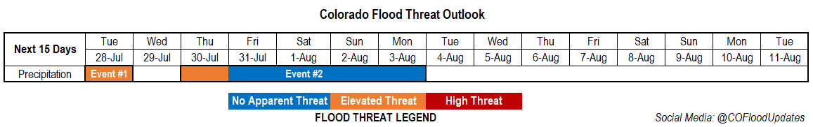
Valid Dates: 7/28– 8/11
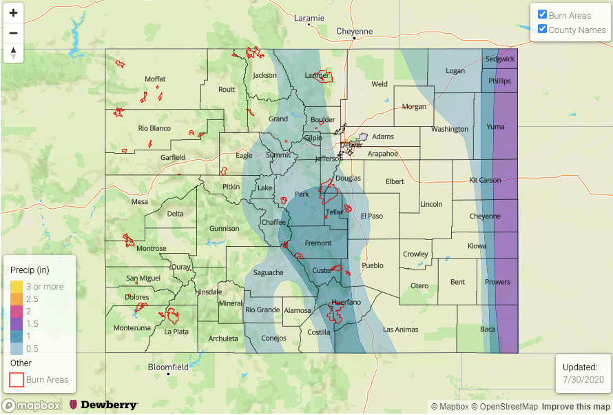
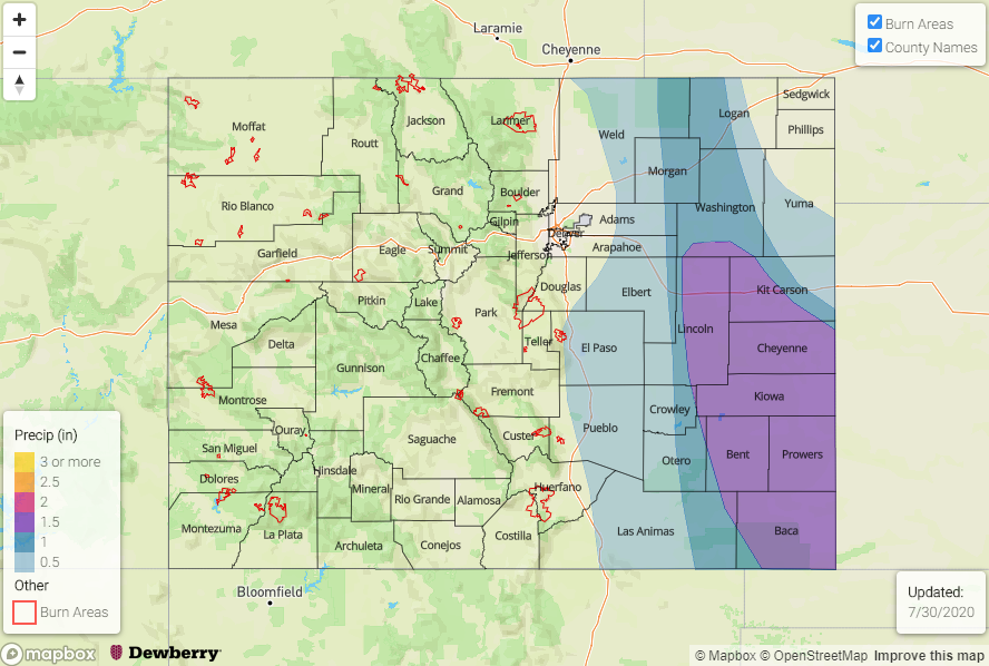
Monsoon season is a reminder how quickly our state can go from extremely dry to overly wet in the course of a few days. The shortwaves/cut off lows that have been sitting over California have helped maintain the plume of moisture over the state with only slight movement west to east. This pattern has also helped push mid-level energy through the flow, which help storms intensify more than they may have otherwise done. AHPS precipitation over the last 7 days (with most precipitation since Thursday) indicates between 3-4 inches have fallen in the western San Juan Mountains and just over 3 inches have fallen over the southern San Juan Mountains in Archuleta, Conejos, Rio Grande County. Yesterday alone, 1.5 to just under 3 inches fell over the Southeast Mountains causing dangerous mud flows over the burn areas (Spring Creek and Decker). The burnt material from the Decker burn area will likely affect the local fisheries as well. The San Luis Valley was also able to reach, and maybe slightly above, its typical July climo values thanks to this multi-day event.
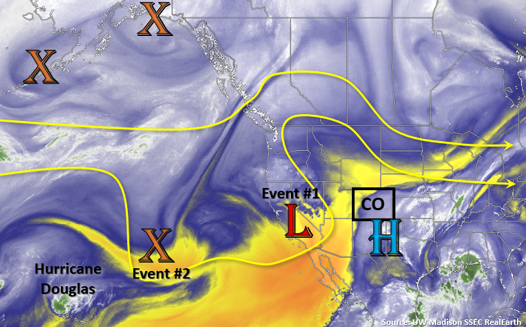
We will have one more day with rainfall as the Low/shortwave moves northwestward around the High (Event #1). Expect showers to start the morning over the Central and Northern Mountains from this feature. As the shortwave arrives to the eastern mountains and spreads into the plains at peak heating, heavy rainfall will be possible for one more day over the plains. By Wednesday, the High begins to build over the Desert Southwest, which will push the higher PW values to our south and east. So finally, a break in rainfall for the state.
By Thursday, Event #2 begins as a strong Low digs south, offshore of the Pacific Northwest, and drives a weak cold front through the eastern plains. Still not quite how much moisture this will bring with it, but depending on the timing passage, it could return the heavy rainfall threat to eastern Colorado (including recent burn areas over the Southeast Mountains).
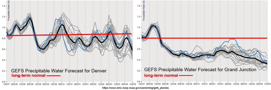
The plumes both show strong downturns in PW values after today (west) and tomorrow (east). Therefore, today will be the last day of this heavy rainfall event for the San Juan Mountains. It’s important to note that mud/debris flows can still happen a couple days after the rain has ended due to the unstable soils. However, they will finally be able to start to dry out and local streams/rivers should begin to recede. PW remains well above 1 inch for tomorrow over eastern Colorado, so an Elevated flood threat has been issued with extra dynamical support for some thunderstorm development. After the strong downtick in PW on Wednesday, there does look to be a quick rebound in PW over eastern Colorado by Thursday afternoon. This indicates that the front could provide a decent moisture environment for heavy rainfall with slower steering winds aloft, so an Elevated flood threat is issued for Thursday with the main focus over the eastern border. Otherwise, there is No Apparent threat for Event #2.
Event #1: Tuesday (7/28)
Elevated Threat as the shortwave moves around the high and brings some extra mid-level energy to the high moisture environment over the eastern plains.
Big question tomorrow will be how much instability can build and where the moisture boundary will set up over the eastern plains. Nonetheless, with slow steering winds, heavy rainfall will be possible with outflow boundaries helping trigger additional convection over the plains. Best chance for heavy rainfall will likely be east of the 104W marker. If some thunderstorms can develop the main threats will be strong outflow winds and small hail due to the freezing height being so high by this time of year). Please tune into the FTB tomorrow for the latest on the details of this event.
Event #2: Thursday – Monday (7/30 – 8/3)
Elevated Threat/No Apparent as a front pushes through the eastern plains (Thursday) and residual moisture fires scattered storms over the mountains each afternoon (Friday-Monday).
It is important to point out that, at this time, this event does not have a strong PW plume associated with it. Therefore, after the (possible) more wetting rainfall on Thursday over eastern Colorado, residual moisture will be recycled for typical, scattered afternoon thunderstorm coverage. Expecting rainfall to stick closer to the mountains for this event with highest totals over the Southeast Mountains. Where rainfall favors formation will be tracked in the daily FTB. Of course, the burn scars will also be monitored each day as they can still have flooding and mud flow issues if storms form and sit over the top of them. All storms for this event can still produce dangerous lightning, so hikers beware and be sure to get off the high peaks by noon.