Issue Date: Thursday, July 23rd, 2020
Issue Time: 3:10PM MDT
Valid Dates: 7/24– 8/7
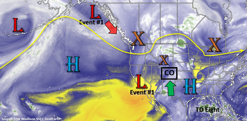
A nice monsoon moisture plume has set up over the state the last couple days, and it has been reinforced by a shortwave/weak Low over California. The location of the High has really funneled a lot of moisture into the state, and on and off shortwaves have helped spark more widespread and intense rainfall. Tomorrow, the Low will begin to eject to the northeast, in similar fashion to yesterday’s shortwave, with the incoming trough marked below. Shortly after, an elongated High will set up to our east, and with more zonal flow to our north and another low dropping into CA, Colorado will be placed under favorable flow for a subtropical moisture tap through early next week. Additionally, a tropical depression might get ingested to flow, which would bring more mid-level energy to the state by early next week.
Wednesday, the High will be located over Colorado, so expecting the atmosphere to dry out a bit and give us a break from the all the rain. The northwesterly flow aloft over eastern Colorado could send some disturbances through the flow, which would likely return moisture to the state for afternoon and evening storms. Expecting that pattern to hold through the weekend, which could also pull enough moisture across the southern mountains for afternoon scattered storms.
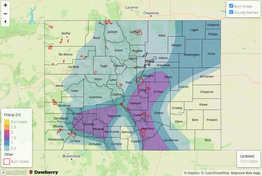
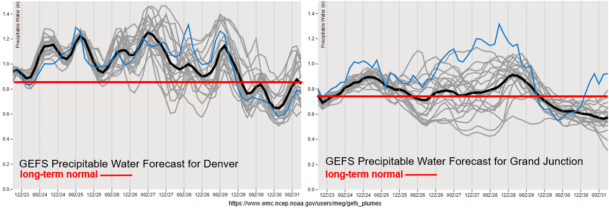
One thing to point out in the moisture plumes below is the large spread both east and west by about Saturday. Further south, there is a clear upward trend in PW for this period, so the images below are showing uncertainty with how far north the higher PW values will make it. With PW well over an inch, an Elevated threat has been issued for the next three days. For Monday and Tuesday, the strong upward trend further south is very pronounced, so a High flood threat has been issued. Slower steering winds also raise concerns for recent burn areas. Please stay tuned to the FTB this weekend, especially if you’re planning on camping or hiking.
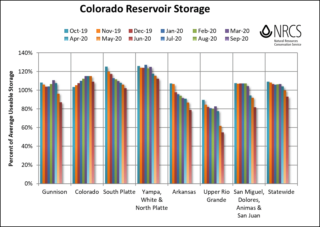
The Colorado reservoir storage maps were released by NRCS yesterday. The most notable feature in the map is the large downward trend over the last couple of months in the Upper Rio Grande Basin. Reservoirs now sit at about 50% capacity and we haven’t even added in July/August water use. Since October 2001, only about 5 years have had above “departure from average storage”. Unsure how this relates to obligated releases downstream, but I’m sure that plays a part.
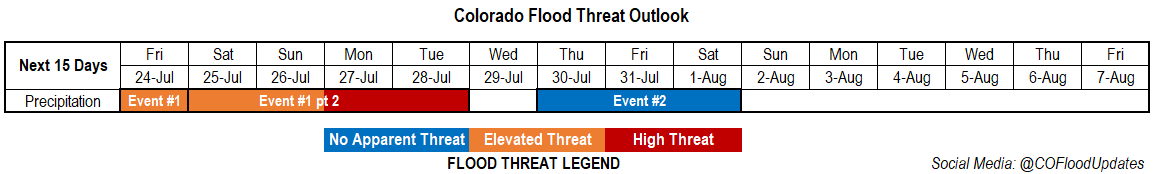
Event #1: Friday – Tuesday (7/24 – 7/28)
High/Elevated Threat as the subtropical moisture takes hold of the state with plenty of shortwaves moving through the flow.
Tomorrow, the Low will begin to eject to the northeast, in similar fashion to yesterday’s shortwave, with the incoming trough. That means western Colorado will get to wake up to some cool, cloudy/rainy conditions. The cloud cover should keep the thunderstorm threat low in the afternoon, but expect storms to return to the San Juan Mountains. As the shortwave moves to the northeast, an uptick in storms over northeast Colorado is also expected. With high moisture values in the area and increased lift, an Elevated flood threat has been issued. The increased moisture levels will continue through next week, and an upwards trend further south will cause a High elevated flood threat for Monday and Tuesday. Multiple rounds of rainfall could also cause increased runoff and make soils unstable, so be sure to follow the FTB and SPM where we track that daily. While instability and upper dynamics may need to be assessed each day, slow steering winds should allow for some higher accumulations. Thus, the recent burn areas will also be watched closely over the next week. The most important feature to communicate is that heavy rainfall is expected to be widespread for this event. Follow the day to day details in the FTB.
Event #2: Thursday – Saturday (7/30 – 8/1)
No Apparent as weak moisture moves into eastern Colorado and across the southern border.
At this time, the threat does not look as serious as this next week’s widespread, heavy rainfall event. This is due to the placement of the high over the state with a weak ridging pattern. Northwest flow could push some weak fronts through the eastern plains, which always have the potential to return low-level moisture, and therefore, afternoon storms. Steering flow will be slow again, so unless there is a boundary for forcing over the plains, storms should stick close to the mountains. Additionally, scattered storms are anticipated across the southern border as some weak moisture is drawn up around the High. Be sure to stay tuned into this event as the details will evolve and change.