FTO 08-17-2020: Active Period with Rainfall Chances Increasing over Western Colorado by this Weekend

Issue Date: Monday, August 17th, 2020
Issue Time: 2:20PM MDT
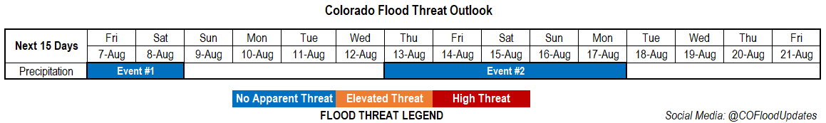
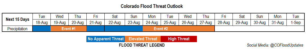
Valid Dates: 8/18– 9/1

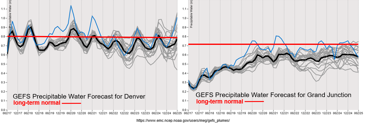
The anomalously strong ridge will stay in place to start the week, which will keep hot temperatures in the forecast statewide. Highs will be on the rise the next couple days over western Colorado with the eastern plains at least getting some relief from the heat as weak cold fronts ever so often move through the north and northwesterly flow. This will keep PW hovering around average over eastern Colorado, and produce a couple days with elevated moisture over the plains. Therefore, afternoon storm chances will remain high for the first portion of the forecast period, although storm coverage may be spotty and mostly confined to the eastern/southern mountains and immediate adjacent plains. It also looks like more shortwave action and higher moisture on Wednesday and Thursday over eastern Colorado, so an Elevated flood threat has been issued.

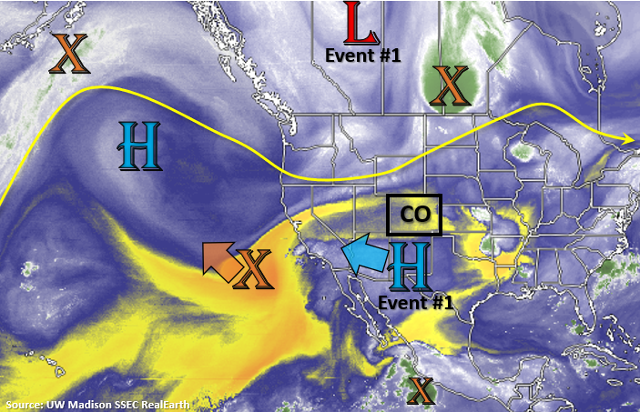
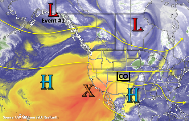
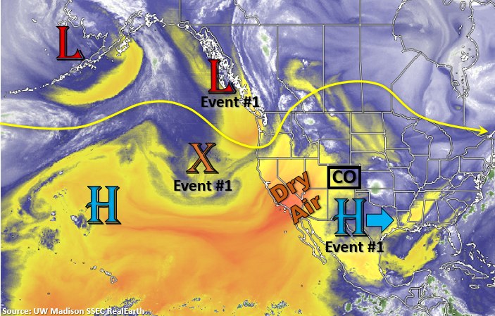
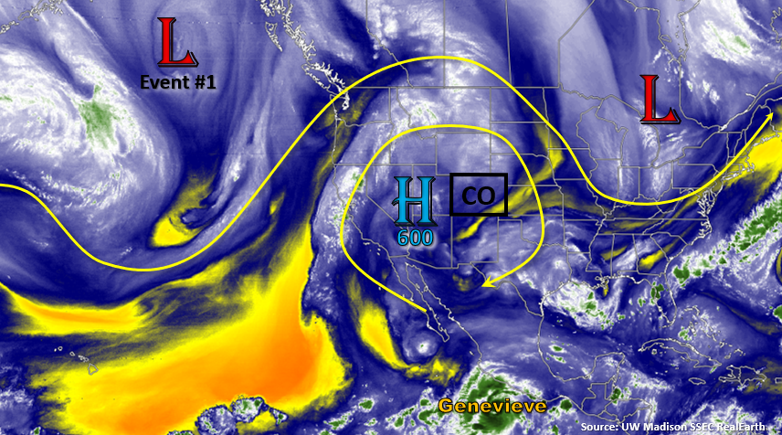
As the next trough moves onshore by the end of the week, it will help to break down the strong ridge and bring some higher moisture back and cooler temperatures back into western Colorado. Unfortunately, the tightening pressure gradient may also mean an increase in the surface wind speeds. By early next week, some of Hurricane Genevieve’s moisture (marked below in orange) and mid-level energy may make its way around the ridge axis and into Colorado. So, an Elevated flood threat has been issued from Monday into Thursday with fingers crossed this pattern continues to develop. The rainfall is very much needed.

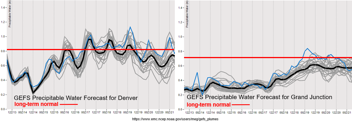
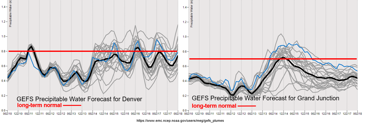
Looking like PW remains around average the next couple days over eastern Colorado. There’s a slight decrease in moisture before Wednesday, thus the No Apparent flood threat for tomorrow. A little bit of spread in the model members by the end of the week, but still plenty of low-level moisture for daily rounds of storms. For the most part, storms should stick to the high terrains and move south, but occasional adjacent plains convection should be expected. You can keep track of that in the daily FTB.

Finally, some more moisture over western Colorado by mid-week. This should help increase relative humidity values, which is good for fighting the ongoing fires. However, increased surface winds and gusty outflow winds from storms that form (and possibly dry lightning) should also be expected as the trough moves inland. While these factors are not helpful for the ongoing fires, the increased moisture will be very welcomed.

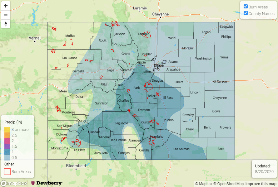
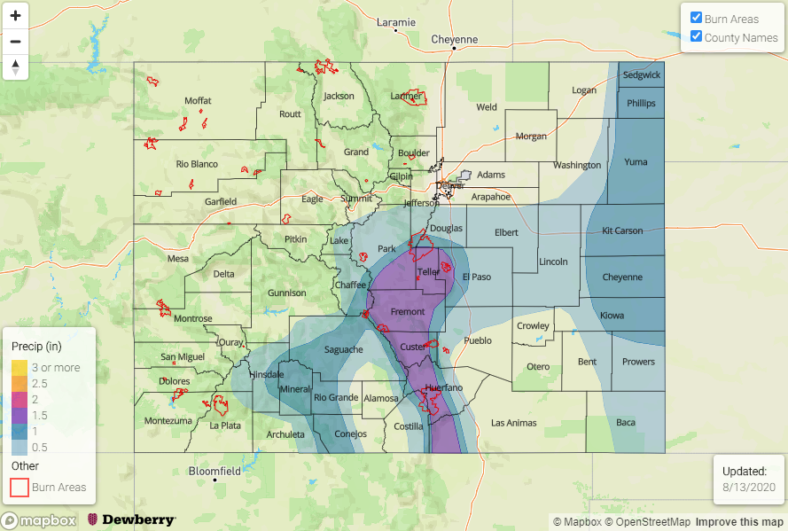
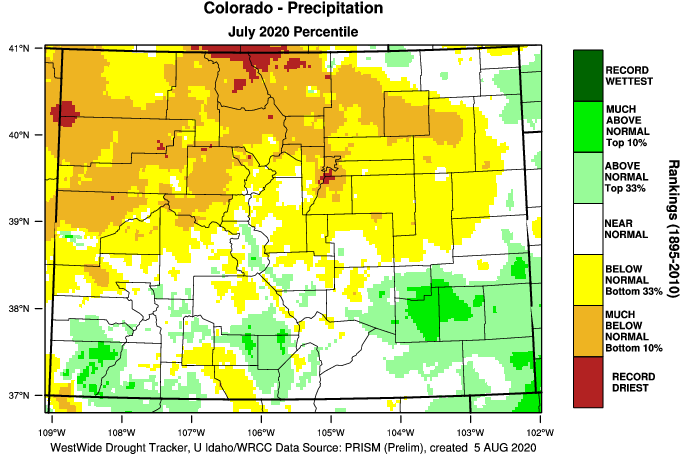
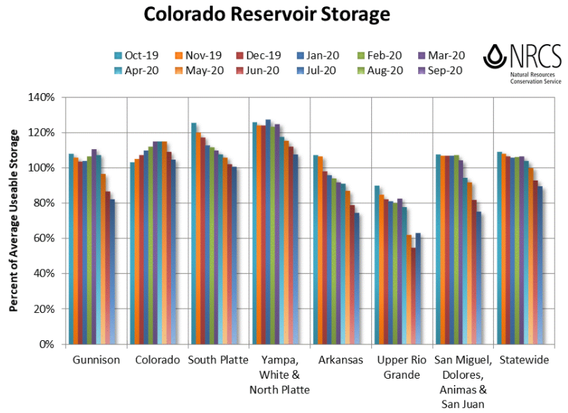
The monthly reservoir storage just came out from the NRCS for the month of July. Despite the very warm and dry conditions, not a large drop off in the percent of average usable storage. In fact, it increased over the Upper Rio Grande with that heavy rainfall event from July 23rd – 28th likely contributing. The Upper Rio Grande now sits at 63% of average with northern Colorado still above 100% of average. Statewide, we are 90% of average with 60% of capacity. For comparison, this time last year, we were 116% of average.
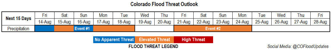
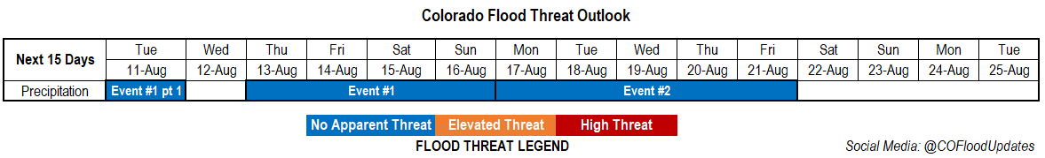
Event #1: TuesdayFriday (8/18 – 8/21)

Elevated/No Apparent for eastern Colorado as on and off mid-level energy and moisture combine for afternoon thunderstorms.

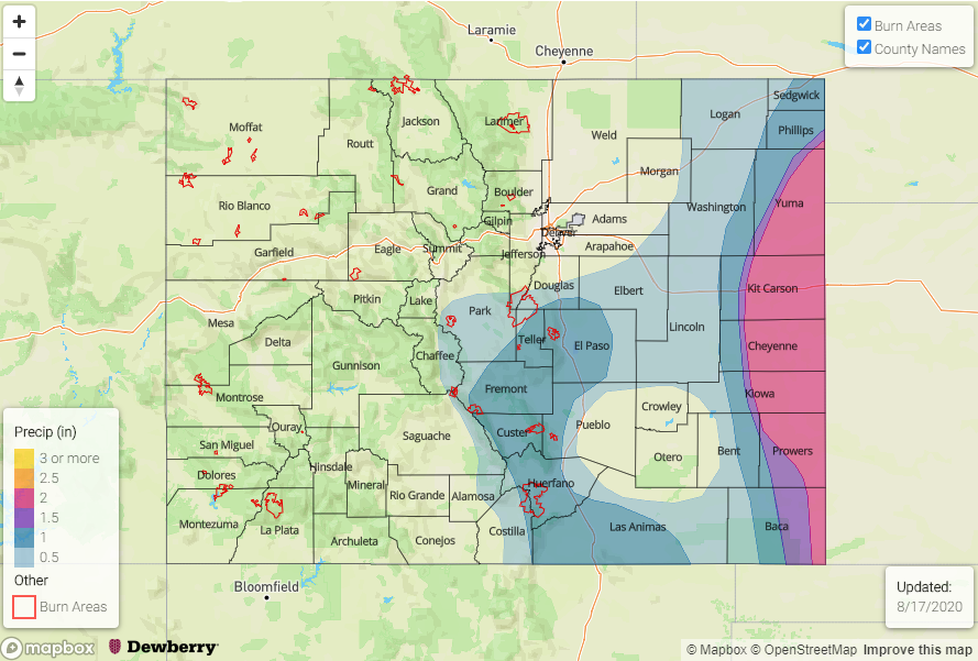
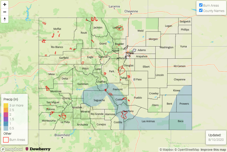
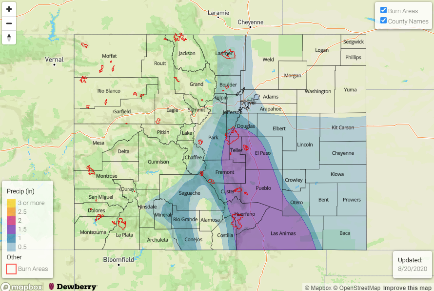
Looking at lee troughing most every afternoon for this event. Tomorrow, it looks like the trough will set up far enough east that the best moisture will be in Kansas, but some storms will be still be possible near the border. On Wednesday and Thursday, the lee troughing looks to help keep moisture higher back to the west, so forecasting more widespread storms forecast over the eastern and southern mountains. With slow steering flow under the ridge, if storms track over burn areas, they may be capable of producing flash flooding along with mud and debris flows. Additionally, some stronger storms over more urban areas could create some nuisance street flooding on days where the storm motion has a slight westerly component. Heavier rainfall should favor the Palmer and Raton Ridge as they move off the mountains due to slightly higher moisture concentration and increased convergence. Without much shear, storms aren’t expected to produce large hail, but you can follow those details as they evolve in the daily FTB.

Event #2: SaturdayThursday (8/22 – 8/27)

Elevated/No Apparent threat as an incoming trough places the ridge axis in a favorable position to transport moisture into the state.

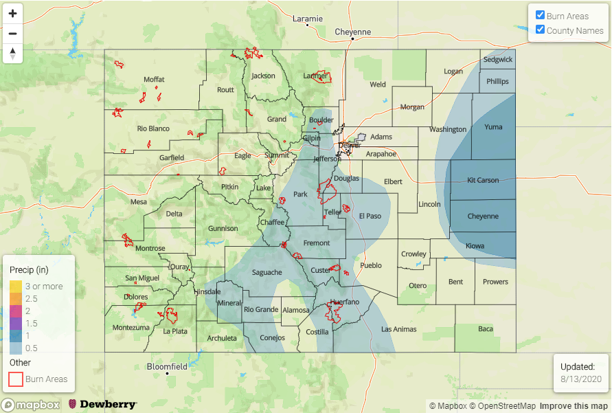
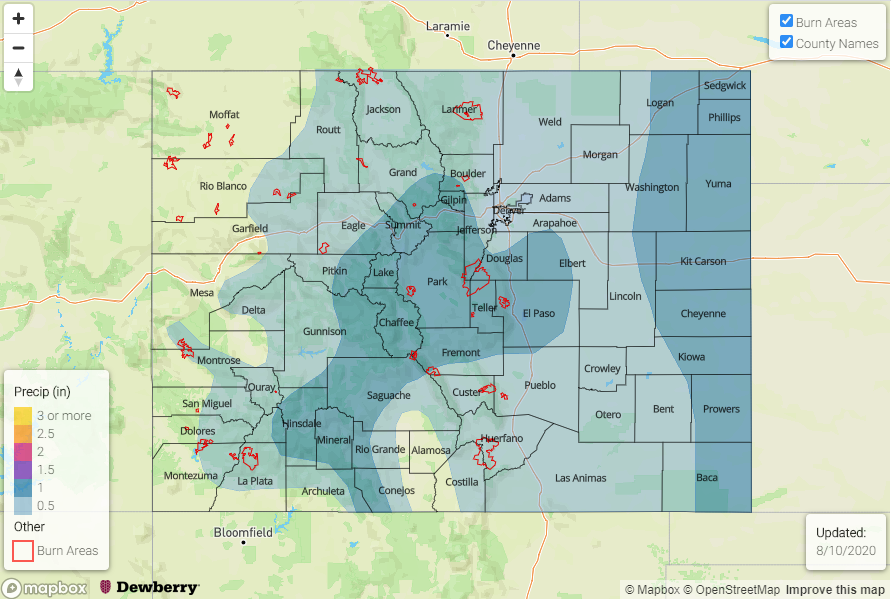
Really hoping that this pattern holds because we need the moisture, especially over western Colorado. Right now, remnant moisture from Genevieve looks to make its way around the ridge and into Colorado by early next week. Still a lot of questions about how much moisture, and which days will have the greatest amounts. But with mid-level energy also moving through the flow, going to go with an Elevated flood threat for this event. Don’t pay too much attention to the map below, just wanted to highlight the areas that will probably see more rainfall than others, and show the chance of precipitation returning to western Colorado. The last day Grand Junction reported more than 0.05 inches of precipitation was on June 30th (0.07 inches), and the Craig-Moffat last saw over 0.05 inches on July 29th (0.22 inches)!

FTO 08-13-2020: High Fire Danger Continues for Western Colorado with Storm Chances Increasing to the East

Issue Date: Thursday, August 13th, 2020
Issue Time: 2PM MDT
Valid Dates: 8/14– 8/28

As the remnants of a tropical depression move to the northwest (orange “X”), the High will start to slide back to the west over the next couple of days. As the High strengthens over the Desert Southwest this next week, expect temperatures to stay hot and slightly increase over western Colorado. More seasonable temperatures are forecast over eastern Colorado after a hot day today and tomorrow. Tonight and into tomorrow, the base of the trough (Event #1) will brush the northern border. This will send a cold front through the plains tomorrow afternoon and return the chances for rainfall over the southern mountains and Southeast Plains. Cooler overnight temperatures are also expected over the adjacent eastern plains Friday night.

Northwesterly flow aloft over eastern Colorado through early next week will keep disturbances moving through the flow, which will keep POPs in the forecast each afternoon. There will likely a break rainfall mid-week as another disturbance moves onshore over the Pacific Northwest and breaks down the High pulling moderate PW values over the state. To start this weekend, a stronger trough moves inland (Event #2), which looks to put the ridge axis slightly to our east. If this plays out, there could be a nice surge of PW northwards. Thus, the Elevated flood threat for Event #2.

It has been dry and hot over the majority of Colorado the last few days. Additionally, windy conditions over western Colorado have been helping fuel and expand the ongoing fires. The explosive growth of the Pine Gulch fire is jaw dropping. As of this morning it had burned 68,323 acres, so it will likely move into the top 5 largest Colorado wildfires shortly. The GEFS is showing PW values in Grand Junction remaining in the 10th percentile before slightly increasing early next week. While some wetting rainfall will be forecast further south, the lightning and gusty outflows winds that are also forecast with storms that fire, are not ideal. Additionally, the GEFS is hinting at increased surface winds next Tuesday and Wednesday. With flow aloft turning more northerly over eastern Colorado by Sunday, there will likely be a shift in the smoke plume as well. Low air quality is anticipated to continue closer to the fires.

Over eastern Colorado, there’s a nice return of moisture Saturday into early next week. If storms are able to fire over the eastern plains, higher rain totals will be possible. So, an Elevated Flood Threat has been issued. Mid-level energy moving on and off through the flow may also allow for some overnight convection on the plains this weekend. Quite a bit of spread in PW values after Tuesday, but an overall decreasing trend translates to a break in precipitation chances by mid-week after a return to more normal values this weekend.

Event #1: FridayTuesday (8/14 – 8/18)

Elevated/No Apparent threat with on and off low-level moisture keeping POP chances relatively high.

As the cold front drops through the plains tomorrow, convection looks to be mostly capped. There is a chance for some afternoon, weak storms over the southern mountains and far corner of the Southeast Plains, but flooding is not expected. Additionally, some overnight rainfall may be possible for the eastern plains. Be sure to tune into the FTB tomorrow to track this. Saturday, rainfall chances look best over the southern mountains and adjacent eastern plains. With high surface moisture still over the area, an Elevated flood threat has been issued. There is also a chance for overnight rainfall again. Sunday, another cold front should move through the eastern plains, so expecting an uptick in afternoon storm coverage over the eastern mountains. Monday and Tuesday southeast surface winds should keep moisture better intact over eastern Colorado. With mid-level disturbances also moving through the northerly flow, an Elevated flood threat has been issued for the eastern plains.

Event #2: FridayMonday (8/21 – 8/24)

Elevated threat as an incoming trough displaces the ridge eastward.

It looks like a stronger trough will move inland next weekend. This could displace the ridge to the east and create a nice PW surge northward with some lee troughing. The stronger the surge, the more widespread the afternoon storms over the mountains. More westerly steering flow would also push the storms into the adjacent eastern plains. Elevated moisture over the eastern plains and mid-level energy moving through the flow could cause storms to drop some heavy rainfall. This event is still pretty far out, so confidence is low, and no precipitation map has been drawn for this reason. The climatologically more active regions of the Palmer Ridge, Wet Mountains, Sangre de Cristos, and Raton Ridge would likely see the largest totals if the details play out as is.

FTO 08-10-2020: Isolated and Scattered Storms Return to the Forecast

Issue Date: Monday, August 10th, 2020
Issue Time: 2:50PM MDT
Valid Dates: 8/11– 8/25

The water vapor imagery below is showing a massive area of dry air over the majority of the western US (yellow and orange). There’s a bit of blue over northern Colorado, which is associated with the weak cold front that moved through the area this morning. This moisture will help return some scattered storms to eastern Colorado today, but a cap and mixing out of surface moisture will keep the storms scattered and high-based with the main threat being brief, outflow winds. Tomorrow, a dry line sets up over the eastern plains with lee troughing, so this will be the main focus for storm coverage as dry air continues to be entrained with the west and southwest flow over the rest of Colorado. The thunderstorms that develop over the border counties should be moving fast enough and have small enough rainfall cores that there is No Apparent threat for flooding at this time.

Brief break in rainfall on Wednesday as the dry air continues to suppress afternoon convection chances and push higher surface moisture into Kansas and Nebraska. By Thursday, the Low marked below moves north of Colorado and some extra mid-level energy will mix with more moisture to return afternoon storms chances. As the High rebuilds and strengthens over the Desert Southwest (Event #1 and #2), scattered storms are expected each afternoon with residual moisture trapped under the ridge. Rainfall looks to favor the southern high terrains with occasional storm activity over the adjacent and eastern plains.

It remains very dry over western Colorado through the end of this week with some possible daily low PW records being broken. PW values also drop off over eastern Colorado after today. This will limit precipitation chances across the state until that Low begins to advance inland. As the Low begins to advance inland, expecting the surface gradient to tighten as a response. With increased surface winds forecast beginning on Wednesday, elevated and critical fire weather conditions are likely over western Colorado and perhaps some mountain valleys. There is a chance for weak storms to return to portions of the San Juan and Central Mountains by Thursday/Friday, but outflow winds from the storms might cause issues with ongoing fires as widespread wetting rainfall is not forecast. Best chance for wetting rains will be over the south high terrains and along/near the Continental Divide, and by Sunday some activity may spill into the adjacent plains.

Event #1: TuesdaySunday (8/11 – 8/16)

No Apparent threat as storms stick mostly to the mountains with a peak in activity on Sunday behind a weak cold front.

Some weak thunderstorms will be possible over the border counties tomorrow with max 1-hour rain rates up to 1.3 inches and severe hail possible. Upper level dynamics will be lacking, so the severity threat is on the lower end; however, storms could also produce some damaging outflow winds. With faster storm movement to the east and southeast, and small storm cores, flooding is not expected. By Thursday, the chances for rainfall increase over the mountains as some mid-level energy and moisture move into the area. Scattered storms and high-bases should keep the flood threat away, but expect a chance of precipitation each afternoon over the southern high terrains. Increased fire weather is also likely by mid-week with the tightening gradient. By Sunday, another weak cold front begins to move south. Depending on the depth of the low-level moisture and arrival time of the front, some more heavy rainfall will be possible over the eastern plains. At this time, there is No Apparent flood threat.

Event #2: MondayFriday (8/17 – 8/21)

No Apparent flood threat as a strengthening High suppresses high PW to the south and east.

With a strengthening High over the Four Corners, rainfall chances will be on the lower end with some hot temperatures arriving back to Colorado. Residual moisture trapped under the ridge should be enough for some scattered afternoon storms on some afternoons over the mountains, but details this far out will change day to day. There is an equal chance that dry air will win out with only afternoon clouds and minimal rainfall. Occasional fronts and mid-level disturbances may increase the chances for some more moderate rainfall over the eastern plains with the northwesterly flow aloft for this period. At this time, there is No Apparent flood threat for Event #2.

FTO 08-07-2020: Extended Period of Warm & Dry Weather

Issue Date: Thursday, August 6th, 2020
Issue Time: 2:25PM MDT
Valid Dates: 8/7– 8/21

A couple more days of rainfall for Event #1, but with No Apparent flood threat. This is due to the flow aloft becoming more west/southwesterly with the migrating High, which will pull in the dry air mass, marked below, over the state. This settle movement of the High is due to the incoming trough marked to our northwest. Some mid-level energy moving through the flow (orange “X”) will combine with energy from the Low and drop into southern California. This will increase shortwave activity over the next couple of days and help slightly enhance chances for precipitation. More zonal flow is anticipated Sunday-Wednesday with a series of stronger troughs passing to our north, which will suppress the High south. Some weak cold fronts could move through the eastern plains, but they aren’t expected to do much more than knock down high temperatures a few degrees. By the end of next week, the ridge looks to rebuild. Mid-level energy is again expected to travel through the state from the southwest, and slightly increased moisture should return storms to the mountains and eastern plains. Not looking a strong monsoon surge for this event, at this time, so No Apparent Threat has been assigned to Event #2.

Just how dry will it get? Both Grand Junction, and then Denver, see a significant drop off in available moisture today and tomorrow. While it does look to rebound somewhat, values are still well below normal for this time of year. The incoming trough is also expected to increase the surface gradient, so surface winds in the 15 to 20 mph range will increase fire danger tomorrow into Saturday with the dry vegetation. The new drought map was released on Tuesday, and now the entire state is classified in one of the drought categories, so it is VERY dry. Be sure to follow NWS for the latest on Red Flag Warnings or spotty critical fire weather, which will also be added to the daily FTB.

With the mid-level energy moving through the flow and some residual moisture under the ridge, weak, isolated precipitation will still be possible Friday and Saturday over the high terrains. Perhaps a few more storms could fire south along the Raton Ridge and southeastern border counties, but heavy rainfall is not anticipated, presently. Ensemble guidance is also showing 850mb temperatures between 30 and 32 degC over the lower elevations over this next week, so there should be a return of slightly higher than normal high temperatures statewide. Again, the cool fronts that move through the eastern plains, may cause a brief cool down.

Below is a quick look at precipitation for the month of July. While the large rainfall event at the end of the month helped catch up some areas, it’s amazing that places over the San Juan Mountains are still below normal or only “above normal”. The Southwest Slope and southern San Juan Mountains had between 0.75 and 1.5 inches above normal (“much above normal”) as far as rankings. The other area that sticks out is the south metro area, which is having it’s record driest year on record. This is also true for portions of Jackson and Larimer counties. For the most part it was dry over northern Colorado, extremely dry over northwest Colorado, and much more wet further south. Again, this southern area was highly influenced by the last, multi-day heavy rainfall event.

Event #1: FridaySaturday (8/7 – 8/8)

No Apparent as weak, scattered storms are forecast each afternoon with passing mid-level energy and residual moisture.

Typically, the return of more westerly flow this time of year helps dry out the atmosphere. That is the case for this next week as well. Slightly more southwesterly flow tomorrow and Saturday near the southern border will help bring isolated showers back into the forecast for the mountains. Best chance for rainfall will be along and near the Continental Divide and over the southern high terrains. With large dew point depressions anticipated, the main threat from storms should be strong outflow winds. This is especially true as the storms move off the mountains into the adjacent plains. Some precipitation over the Southeast Plains will also be possible, but flooding and severe storms are not anticipated. There is No Apparent flood threat for this event. The map below shows the most likely area to receive 0.5 inches for this event, but only isolated totals up to this amount are anticipated. Slightly higher than normal afternoon temperatures are anticipated over western Colorado with the rest of the state near normal. The HRRR is also showing hazy conditions with all the fires in the area, so this may bring down air quality a bit.

Event #2: ThursdayMonday (8/13 – 8/17)

No Apparent as a weak trough ejects off the coast of California and returns moisture to the area.

Looks like moisture will return first from the southeast and then push east with the next shortwave moving through the flow. This should return storms chances by the end of next week. The axis of the ridge as it rebuilds will be monitored closely as this directly relates to how much moisture will return and where the best chance for precipitation will be. With southwest flow aloft anticipated, highlighted the area with the best chance of storms in the map below. Details will change, so please tune back into the FTO on Monday for the latest.