Issue Date: Thursday, August 13th, 2020
Issue Time: 2PM MDT
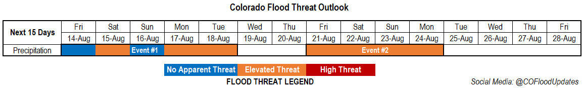
Valid Dates: 8/14– 8/28
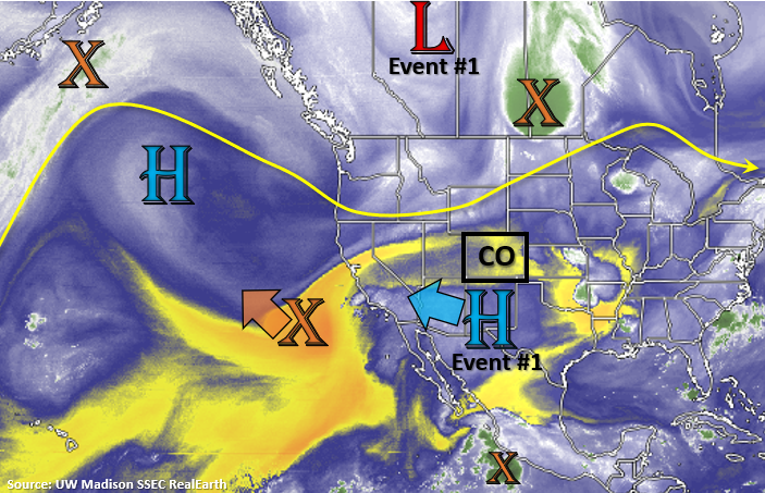
As the remnants of a tropical depression move to the northwest (orange “X”), the High will start to slide back to the west over the next couple of days. As the High strengthens over the Desert Southwest this next week, expect temperatures to stay hot and slightly increase over western Colorado. More seasonable temperatures are forecast over eastern Colorado after a hot day today and tomorrow. Tonight and into tomorrow, the base of the trough (Event #1) will brush the northern border. This will send a cold front through the plains tomorrow afternoon and return the chances for rainfall over the southern mountains and Southeast Plains. Cooler overnight temperatures are also expected over the adjacent eastern plains Friday night.
Northwesterly flow aloft over eastern Colorado through early next week will keep disturbances moving through the flow, which will keep POPs in the forecast each afternoon. There will likely a break rainfall mid-week as another disturbance moves onshore over the Pacific Northwest and breaks down the High pulling moderate PW values over the state. To start this weekend, a stronger trough moves inland (Event #2), which looks to put the ridge axis slightly to our east. If this plays out, there could be a nice surge of PW northwards. Thus, the Elevated flood threat for Event #2.
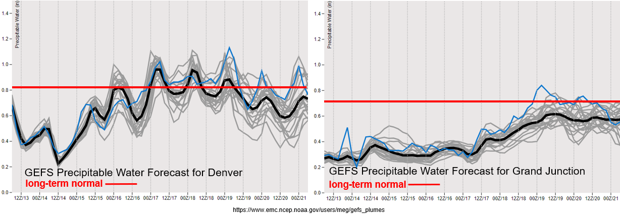
It has been dry and hot over the majority of Colorado the last few days. Additionally, windy conditions over western Colorado have been helping fuel and expand the ongoing fires. The explosive growth of the Pine Gulch fire is jaw dropping. As of this morning it had burned 68,323 acres, so it will likely move into the top 5 largest Colorado wildfires shortly. The GEFS is showing PW values in Grand Junction remaining in the 10th percentile before slightly increasing early next week. While some wetting rainfall will be forecast further south, the lightning and gusty outflows winds that are also forecast with storms that fire, are not ideal. Additionally, the GEFS is hinting at increased surface winds next Tuesday and Wednesday. With flow aloft turning more northerly over eastern Colorado by Sunday, there will likely be a shift in the smoke plume as well. Low air quality is anticipated to continue closer to the fires.
Over eastern Colorado, there’s a nice return of moisture Saturday into early next week. If storms are able to fire over the eastern plains, higher rain totals will be possible. So, an Elevated Flood Threat has been issued. Mid-level energy moving on and off through the flow may also allow for some overnight convection on the plains this weekend. Quite a bit of spread in PW values after Tuesday, but an overall decreasing trend translates to a break in precipitation chances by mid-week after a return to more normal values this weekend.
Event #1: Friday – Tuesday (8/14 – 8/18)
Elevated/No Apparent threat with on and off low-level moisture keeping POP chances relatively high.
As the cold front drops through the plains tomorrow, convection looks to be mostly capped. There is a chance for some afternoon, weak storms over the southern mountains and far corner of the Southeast Plains, but flooding is not expected. Additionally, some overnight rainfall may be possible for the eastern plains. Be sure to tune into the FTB tomorrow to track this. Saturday, rainfall chances look best over the southern mountains and adjacent eastern plains. With high surface moisture still over the area, an Elevated flood threat has been issued. There is also a chance for overnight rainfall again. Sunday, another cold front should move through the eastern plains, so expecting an uptick in afternoon storm coverage over the eastern mountains. Monday and Tuesday southeast surface winds should keep moisture better intact over eastern Colorado. With mid-level disturbances also moving through the northerly flow, an Elevated flood threat has been issued for the eastern plains.
Event #2: Friday – Monday (8/21 – 8/24)
Elevated threat as an incoming trough displaces the ridge eastward.
It looks like a stronger trough will move inland next weekend. This could displace the ridge to the east and create a nice PW surge northward with some lee troughing. The stronger the surge, the more widespread the afternoon storms over the mountains. More westerly steering flow would also push the storms into the adjacent eastern plains. Elevated moisture over the eastern plains and mid-level energy moving through the flow could cause storms to drop some heavy rainfall. This event is still pretty far out, so confidence is low, and no precipitation map has been drawn for this reason. The climatologically more active regions of the Palmer Ridge, Wet Mountains, Sangre de Cristos, and Raton Ridge would likely see the largest totals if the details play out as is.