Issue Date: Thursday, August 6th, 2020
Issue Time: 2:25PM MDT
Valid Dates: 8/7– 8/21
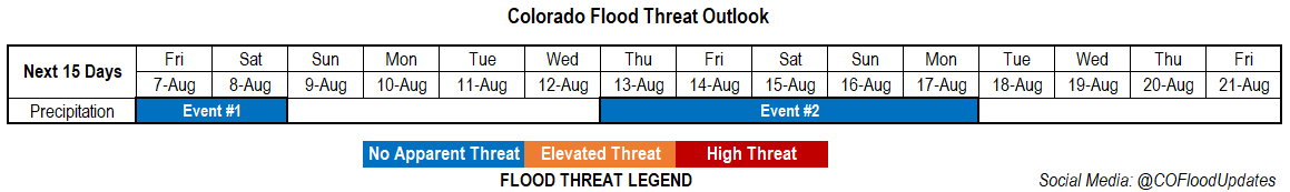
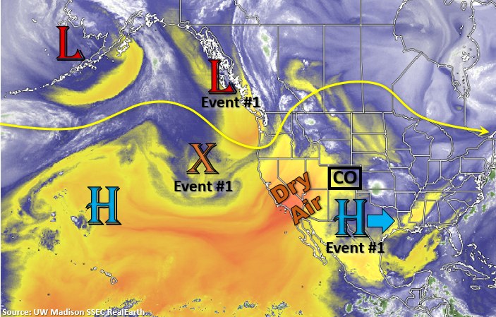
A couple more days of rainfall for Event #1, but with No Apparent flood threat. This is due to the flow aloft becoming more west/southwesterly with the migrating High, which will pull in the dry air mass, marked below, over the state. This settle movement of the High is due to the incoming trough marked to our northwest. Some mid-level energy moving through the flow (orange “X”) will combine with energy from the Low and drop into southern California. This will increase shortwave activity over the next couple of days and help slightly enhance chances for precipitation. More zonal flow is anticipated Sunday-Wednesday with a series of stronger troughs passing to our north, which will suppress the High south. Some weak cold fronts could move through the eastern plains, but they aren’t expected to do much more than knock down high temperatures a few degrees. By the end of next week, the ridge looks to rebuild. Mid-level energy is again expected to travel through the state from the southwest, and slightly increased moisture should return storms to the mountains and eastern plains. Not looking a strong monsoon surge for this event, at this time, so No Apparent Threat has been assigned to Event #2.
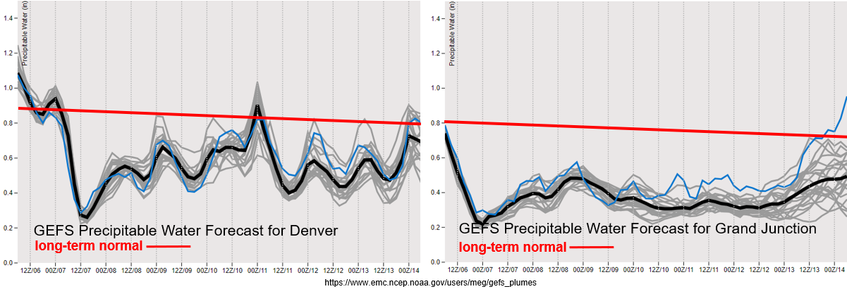
Just how dry will it get? Both Grand Junction, and then Denver, see a significant drop off in available moisture today and tomorrow. While it does look to rebound somewhat, values are still well below normal for this time of year. The incoming trough is also expected to increase the surface gradient, so surface winds in the 15 to 20 mph range will increase fire danger tomorrow into Saturday with the dry vegetation. The new drought map was released on Tuesday, and now the entire state is classified in one of the drought categories, so it is VERY dry. Be sure to follow NWS for the latest on Red Flag Warnings or spotty critical fire weather, which will also be added to the daily FTB.
With the mid-level energy moving through the flow and some residual moisture under the ridge, weak, isolated precipitation will still be possible Friday and Saturday over the high terrains. Perhaps a few more storms could fire south along the Raton Ridge and southeastern border counties, but heavy rainfall is not anticipated, presently. Ensemble guidance is also showing 850mb temperatures between 30 and 32 degC over the lower elevations over this next week, so there should be a return of slightly higher than normal high temperatures statewide. Again, the cool fronts that move through the eastern plains, may cause a brief cool down.
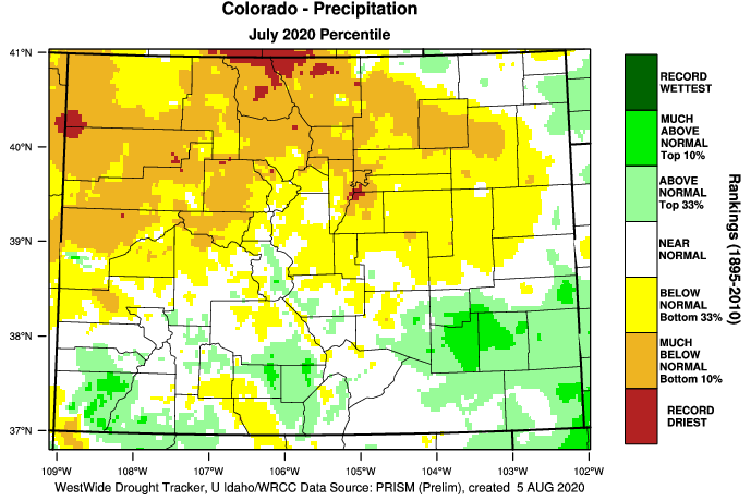
Below is a quick look at precipitation for the month of July. While the large rainfall event at the end of the month helped catch up some areas, it’s amazing that places over the San Juan Mountains are still below normal or only “above normal”. The Southwest Slope and southern San Juan Mountains had between 0.75 and 1.5 inches above normal (“much above normal”) as far as rankings. The other area that sticks out is the south metro area, which is having it’s record driest year on record. This is also true for portions of Jackson and Larimer counties. For the most part it was dry over northern Colorado, extremely dry over northwest Colorado, and much more wet further south. Again, this southern area was highly influenced by the last, multi-day heavy rainfall event.
Event #1: Friday – Saturday (8/7 – 8/8)
No Apparent as weak, scattered storms are forecast each afternoon with passing mid-level energy and residual moisture.
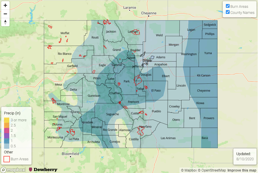
Typically, the return of more westerly flow this time of year helps dry out the atmosphere. That is the case for this next week as well. Slightly more southwesterly flow tomorrow and Saturday near the southern border will help bring isolated showers back into the forecast for the mountains. Best chance for rainfall will be along and near the Continental Divide and over the southern high terrains. With large dew point depressions anticipated, the main threat from storms should be strong outflow winds. This is especially true as the storms move off the mountains into the adjacent plains. Some precipitation over the Southeast Plains will also be possible, but flooding and severe storms are not anticipated. There is No Apparent flood threat for this event. The map below shows the most likely area to receive 0.5 inches for this event, but only isolated totals up to this amount are anticipated. Slightly higher than normal afternoon temperatures are anticipated over western Colorado with the rest of the state near normal. The HRRR is also showing hazy conditions with all the fires in the area, so this may bring down air quality a bit.
Event #2: Thursday – Monday (8/13 – 8/17)
No Apparent as a weak trough ejects off the coast of California and returns moisture to the area.
Looks like moisture will return first from the southeast and then push east with the next shortwave moving through the flow. This should return storms chances by the end of next week. The axis of the ridge as it rebuilds will be monitored closely as this directly relates to how much moisture will return and where the best chance for precipitation will be. With southwest flow aloft anticipated, highlighted the area with the best chance of storms in the map below. Details will change, so please tune back into the FTO on Monday for the latest.