FTO 09-14-2020: Unseasonably Warm with Dry Conditions Until this Weekend

Issue Date: Monday, September 14th, 2020
Issue Time: 1:50PM MDT
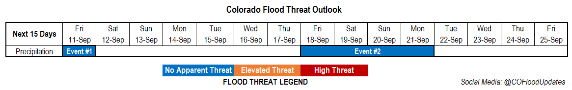
Valid Dates: 9/15 – 9/29

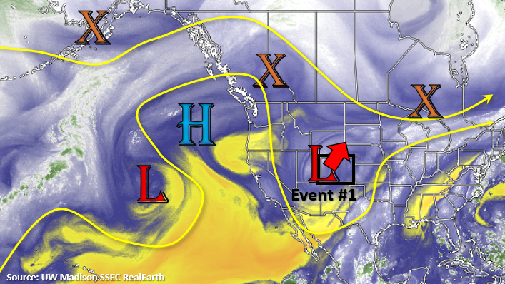
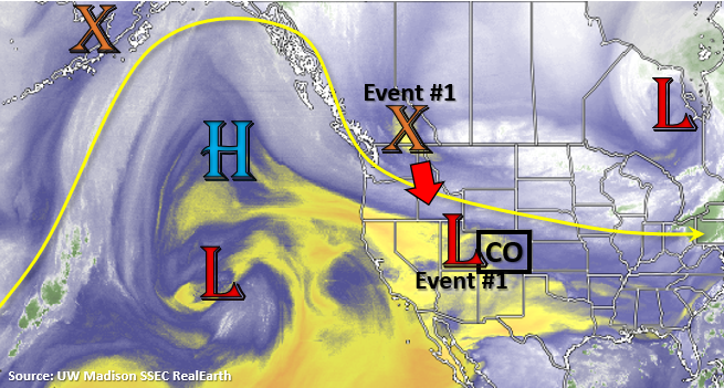
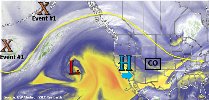
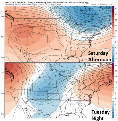
It’s setting up to be a warm, dry, and uneventful week as an elongated ridge sets up overhead. Slight movement in the High tomorrow will start to pull smoke back into the state from the wildfires across the western US. So, expect a decrease in surface visibility by early afternoon across the northern border. As the near surface smoke wraps around the High, it will be pulled south throughout the day. Event #1 will start to set up to our west over the next couple of days as an upper Low becomes cut off from the main flow and spins off the west coast. Another incoming trough will push the Low inland this weekend, which will in turn, suppress the High to our south. This will return rainfall chances and bring more seasonable temperatures to the forecast until the next ridge begins to build overhead at the end of next week.

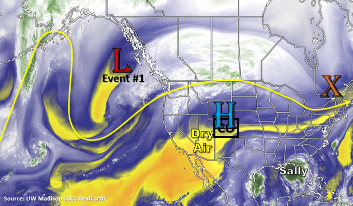
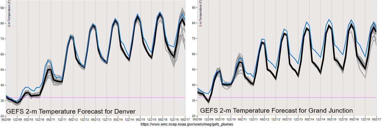
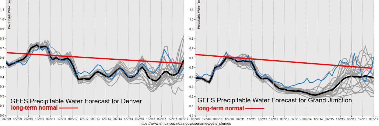
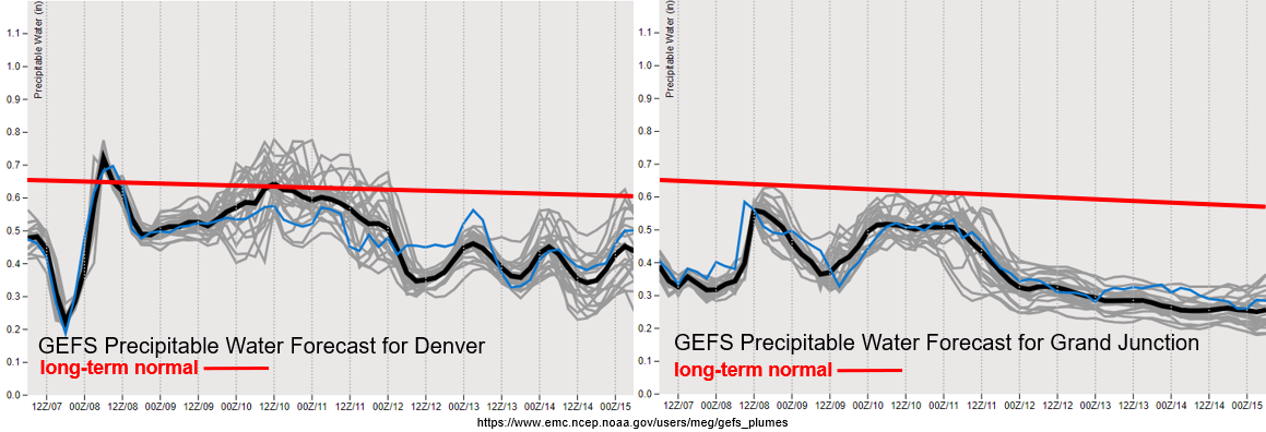
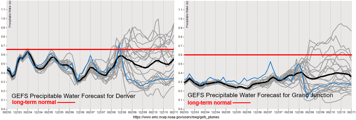
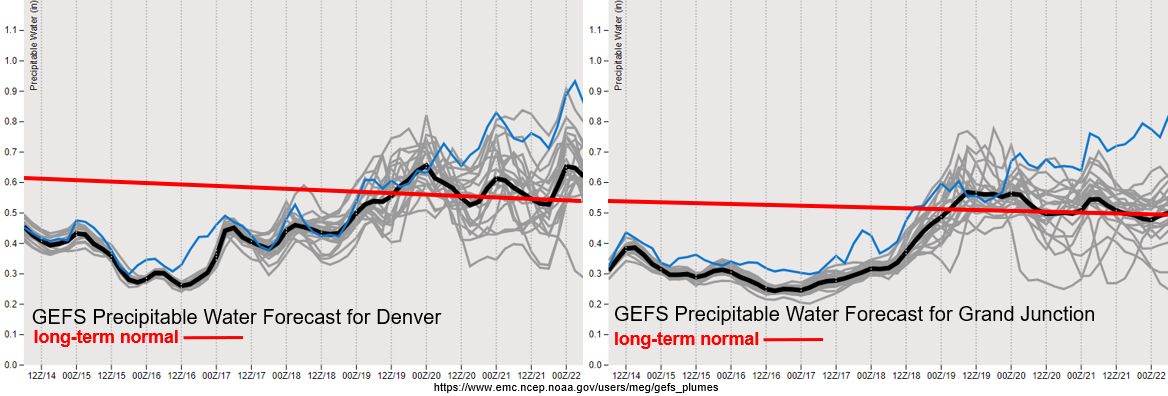
Dry air will continue to reside over the state to start the week (yellow above), so outside of some scattered, high-based light showers over the mountains, Colorado is not looking at any rainfall. This can also be seen by the well below average PW values until the incoming Low moves inland. There are still a few unknowns with the forecast for Event #1. One being how much moisture the Low will carry eastward, which is shown the spread in model members (gray lines). It may be able to interact with a northward moving tropical disturbance, and if it does, this would increase the chances of precipitation over western Colorado. If it does not, it becomes a drier forecast for the western border, so there’s a good chance for elevated fire conditions on Saturday as the system moves overhead. The other unknown is strength and timing of the disturbance. The GFS has a bit of a broader trough passing to our north and slightly faster than the GDPS and ECMWF. The GDPS and ECMWF also created a stronger amplitude trough, so we’ll have to see how the models come into agreement as the week progresses. Either way there is No Apparent Flood threat as scattered showers and storms return to the forecast for a few days.
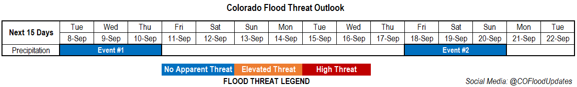
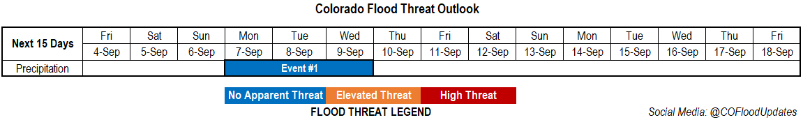
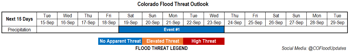
Event # SaturdayWednesday (9/19 – 9/23)

No Apparent flood threat as a cut off Low moves inland and returns precipitation chances.

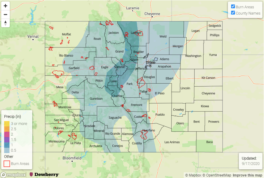
Long-term models are still in a disagreement with the finer details of this event, but it looks like cooler and wetter weather is on its way at the end of next weekend. The Low will arrive on Saturday, and as it moves east, expect a cold front to move through the state and cool temperatures down to more seasonable values for Sunday. As the front drops south, it may return light rainfall to the northern mountains. For Sunday and Monday, there’s an increase in rainfall chances over this same area, but chances also increase over the adjacent plains with a lee trough setting up. On Tuesday, a shortwave, with tropical origins, looks like it will move through the zonal flow. This will translate to more widespread showers over the mountains before the ridge builds overhead on Thursday. We’ll continue to keep watching this event as it may impact recent burn areas depending on its moisture content. Before the ridge begins to build overhead, it looks like there will be another surge of northerly flow on Wednesday associated with a system over the upper Midwest. This should keep temperatures more seasonable through the end of next week and push the remaining moisture south and east of the state. So outside of some light showers over the southern mountains with residual moisture on Wednesday, it should remain dry.

FTO 09-10-2020: Dry Weather Ahead with Temperatures Warming Back Up

Issue Date: Thursday, September 10th, 2020
Issue Time: 2:45PM MDT
Valid Dates: 9/11– 9/25

Event #1 is a quick one-day event as the upper Low continues to lift to the northeast. Some scattered, lingering snow showers are possible over the northern mountains tomorrow morning, but it should clear up by midday. There may also be some light, wrap around precipitation over the northeast corner of the state during the afternoon, but other than that, it should remain dry. There is No Apparent flood threat. Winds are also expected to pick up over the mountains and Southwest Slope during the afternoon as the jet moves overhead, so some elevated fire weather may be possible. Cooler temperatures may help alleviate this hazard, but be sure to tune into the FTB tomorrow morning.

A ridge begins to build back over the western US this weekend and will hang through next week, so mild weather is on tap. A lot of variation from model run to model run in strength and timing, but it looks like the next Low will drop in sometime at the end of next week (Event #2). This will bring precipitation chances back into the forecast.

As this ridge builds in from the west tomorrow, there will a sharp increase in temperatures across the state the next couple of days, which is shown below. There’s a bit more of a diurnal swing over the western Colorado (right), but overall, we are looking at temperatures returning to more seasonal values by Sunday. The early season snowstorm will seem like a distant memory by Tuesday as high temperatures will be back in the upper 80Fs. Feeling confident about the increase in temperatures due to good model member agreement through the forecast period.

PW really drops off after tomorrow morning (western Colorado) as the Low tracks to the northeast. With PW dropping to well below normal values going into this weekend, rainfall is not in the forecast. PW drops off over eastern Colorado after tomorrow morning, and subsidence behind the Low should keep rainfall chances low. It’ll be a stretch of warm and dry weather for most of the week. The change in the weather pattern can be seen on the tail end of the PW forecasts, but the large disagreement between members on moisture return means there’s a chance for very little rainfall. If this is the case, there may be some increased fire weather towards the end of the week. With PW looking to stay below 0.75 inches for the worst case scenario, there is No Apparent flood threat for Event #2 at this time.

Event #2 FridayMonday (9/18 – 9/21)

No Apparent flood threat as the next Low breaks down the ridge and returns some higher moisture to the state for some afternoon rainfall.

Some models are showing an open wave, while other models are showing another cut off Low. Either way, chances for precipitation will increase towards the end of this week. It will be a much warmer system than this last event, so expecting all rainfall at this point in time. Global models are also showing different timing for the arrival, but this will likely only be two to three-day event during this period. A lot of details will change due to it starting 160 hours from now, so there is Low confidence in the details. The precipitation map below shows a higher end rainfall scenario mostly from the GFS.

FTO 09-07-2020: Rain & Snow Behind a 40F to 50F+ Drop in Temperatures

Issue Date: Monday, September 7th, 2020
Issue Time: 2:15PM MDT
Valid Dates: 9/8– 9/22

It’s time for the winter weather alarm to be officially sounded! A big change is on the way tonight as an upper trough digs south and turns the upper flow southwest, but not before another day of above average temperatures and dry conditions. While it’s pretty great BBQ weather for Labor Day, it will be a bit smoky with the HRRR smoke showing a lot of near surface smoke across the state. This evening the cold front rushes across the northern border, which will likely produce some strong wind gusts (up to 60 mph) as it passes overhead and moves south. Behind the front, a large temperature drop is expected along with the beginning of the precipitation. Expect precipitation first over the Front Range, Urban Corridor, and Northeast Plains, and then over the Northern Mountains and Northwest Slope. Over the highest terrains, the crossover from rain to snow will occur first, and pretty quickly, while the lower elevations should crossover sometime late tomorrow morning after some extra evaporative cooling. With non-frozen soils, warm cement, and heavy snow (low liquid to snow equivalent), the snow totals may be a bit lower than they would typically be. This is especially true over the lower elevations.

Tomorrow morning, the precipitation is expected to expand southwards, first over the eastern high terrains and then over the western Colorado. At the same time, the snow line will drop in elevation leaving roads slick. This is also when the trough strengths and becomes a cut off low over Utah (shown in the map below). It will rotate over the region for a couple of days before lifting to the northeast Thursday night into Friday. This should keep precipitation in the forecast through Thursday. By Wednesday evening, expect the transition from snow back to rain as temperatures increase slightly over the lower elevations.

Below is the GFS temperature forecast for 6PM tonight. You can see the above average temperatures over the state today, but also the cold front at the northern border. Behind the front, temperatures drop to well below normal. By tomorrow afternoon, highs will be well below normal with most areas of the state >20F below normal for early September. The earliest snowfall for Denver was September 3, 1961, so we won’t be breaking that record. Temperatures should remain warm enough over the Grand Valley that only rainfall is anticipated at this time. A freeze warning is in effect for the Northeast Plains, Palmer Ridge, Upper Yampa River Basin, and San Luis Valley/Raton Ridge (below 8500ft) from Tuesday into Wednesday. Be sure to follow your local NWS office for the latest on these warnings. With below freezing temperatures anticipated for Tuesday and Tuesday night along the I-25 corridor (30F or slightly less), you might want to drain or cover your sprinkler system and cover your garden.

There looks to be a slight drop in PW values across the state behind the front before the Low draws some more moisture back into the state. So, expected a decrease in precipitation coverage starting Tuesday night (east) and Wednesday morning (west). On Wednesday and Thursday, snow and rainfall will be more limited in coverage, and by Thursday the plains will likely transition back into rainfall. The snow and stratiform precipitation mean there is No Apparent flood threat as precipitation will be rather gradual. It dries out and warms back up for the weekend, and rainfall chances don’t return for quite some time (Event #2). Low confidence in Event #2 occurring, and won’t mention more than just – it will be awhile before the next round of precipitation.

Event #1: TuesdayThursday (9/8 – 9/10)

No Apparent threat as very cold temperatures filter in from the north and an early season snowfall occurs.

As far as snow totals go, it’s a tough forecast with the snow to liquid ratio, timing of the crossover from rain to snow, and warm ground. Generally, I think we’re looking at totals below with snow bands producing some localized higher totals:

  • 1-3” for the Urban Corridor
  • 4-6” for the western Palmer Ridge/Raton Ridge
  • 7-12” for the Front Range/Southeast Mountains
  • 6-10” for the San Juan Mountains
  • 6-10” for the Central Mountains (more isolated)
  • 5-9” for the Northern Mountains (very isolated and north)
  • 2-4” for the Northwest Slope (highest elevations)
  • 1-3” for the San Luis Valley
  • 0-2” for the Northeast Plains (decreasing further east)
  • No snowfall for the Grand Valley, Southwest Slope, & Southeast Plains

As far as impacts, with vegetation still on the trees, broken limbs and power outages will be possible. For roads, it could get slushy and icy at first with more snow accumulating on the roads in the mountains on Tuesday. Wednesday’s commute for the Urban Corridor/Palmer Ridge will probably be a little worse than Tuesday. Freezing temperatures will likely damage crops and gardens, and frozen sprinkler lines will be possible. Additionally, snow could be heavy at times (under the snow bands), and increased surface winds could cause some limited visibility. One good thing to come out of the event will be increased fire containment. The last couple dry and windy days have not been good, especially for the Pine Gulch fire up north.

FTO 09-03-2020: Big Cool Down Coming After Another Hot, Dry Weekend

Issue Date: Thursday, September 3rd, 2020
Issue Time: 2:25PM MDT
Valid Dates: 9/4– 9/18

It’s shaping up to be hot and dry this weekend as the High moves slightly east and starts to rebuild its strength. This will produce an amplified ridge pattern with little to no rainfall forecast over the state. Other than some fair-weather cumulus, mostly clear conditions are expected. The location of the High will likely pull in some smoke from the west, so visibility may decrease as the weekend continues. The summer pattern will come to an end early next week, and Event #1 will bring both precipitation and our first real cool blast of the season. The snow line will likely drop fairly low, too, so expect some snow over the mountains and foothills.

PW continues to remain below normal both east and west of the Continental Divide through early next week. Along with dry low levels, there has also been a strong cap in place the last couple of days (east), so what little moisture remains hasn’t been able to be tapped into. Quite the divergence between moisture return between the model members for the next system (Event #1). There’s a high likelihood of some precipitation (and snow) Monday night into Tuesday, but the global models diverge quite a bit after that. The European model creates a cut off low, which would bring much higher totals and keep precipitation chances in the forecast through the end of the week. The GFS, on the other hand, keeps an open upper trough and places it slightly east of the state. If the latter occurs, there will be little precipitation for western Colorado. So, there’s low confidence in this forecast, but at this time there is No Apparent flood threat.

Just wanted to show how strong this change is going to be. The 500mb height anomaly from the GEFS is below. On top is Saturday afternoon and on the bottom is Tuesday night. Basically, we go from a really strong ridge (hot temperatures) to a strong, positively tilted trough (very cold temperatures). Below the 500mb height anomalies is the 2-meter temperature for Denver (left) and Grand Junction (right). After the cold front passes through, the high, average temperature over Denver drops about ~40F! While the drop in temperature isn’t quite as strong over Grand Junction, the change in the afternoon high temperature is still about ~25F after the front passes through. This cold snap could bring the snow line down to about ~6500 feet, but of course a lot can change in the details by next week. As we near the event, the final solution should become a bit clearer, so we’ll continue to watch model trends over the weekend and report back on Monday. The cooler temperatures only hang around for a couple of days before more seasonable temperatures return to the forecast.

Event #1: Monday Wednesday (9/7 – 9/9)

No Apparent threat as a cold blast returns precipitation chances early next week.

The large portion of the event should occur late Monday night into Tuesday. Residual moisture may allow for a couple scattered storms over the mountains on Wednesday if subsidence isn’t too strong behind the departing trough. As the front passes through, expect some very strong wind gusts due to the tight surface gradient. For the most part, the rainfall should be gradual enough (stratiform) that flooding should be avoided for the lower elevations. With snow in the mountains forecast, not thinking this will cause any flooding concerns either. The real question is how low the snow line will drop. It’s likely that there could be some snow accumulation over the Palmer Ridge if the event follows the latest GFS runs. The European model is a bit warmer, but still showing snow for most of the high elevations, which includes the foothills. If the precipitation continues into Wednesday and Thursday, like the European model suggests, there will likely be a transition back to rainfall with only the highest peaks experiencing snowfall for the full period. In that case, there is a slight chance for some rain on snow (increased runoff), but at this time there is No Apparent flood threat. The precipitation map below is the best blend of model solutions that I could come up with. Be sure to tune back in on Monday for the latest.