Issue Date: Thursday, September 3rd, 2020
Issue Time: 2:25PM MDT
Valid Dates: 9/4– 9/18
It’s shaping up to be hot and dry this weekend as the High moves slightly east and starts to rebuild its strength. This will produce an amplified ridge pattern with little to no rainfall forecast over the state. Other than some fair-weather cumulus, mostly clear conditions are expected. The location of the High will likely pull in some smoke from the west, so visibility may decrease as the weekend continues. The summer pattern will come to an end early next week, and Event #1 will bring both precipitation and our first real cool blast of the season. The snow line will likely drop fairly low, too, so expect some snow over the mountains and foothills.
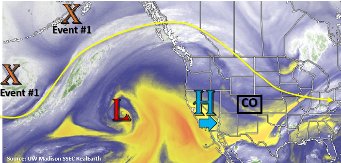
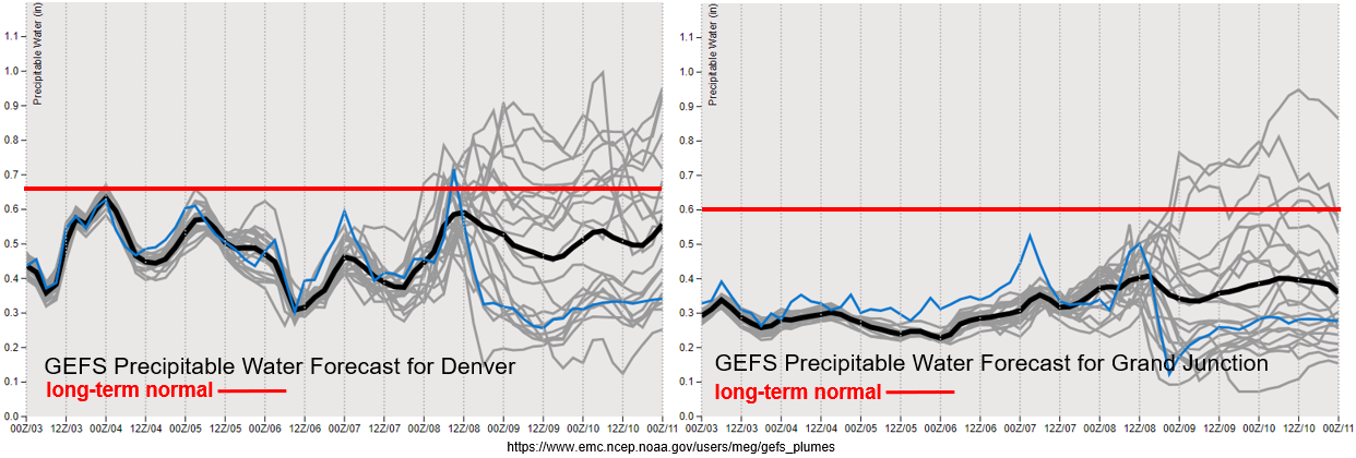
PW continues to remain below normal both east and west of the Continental Divide through early next week. Along with dry low levels, there has also been a strong cap in place the last couple of days (east), so what little moisture remains hasn’t been able to be tapped into. Quite the divergence between moisture return between the model members for the next system (Event #1). There’s a high likelihood of some precipitation (and snow) Monday night into Tuesday, but the global models diverge quite a bit after that. The European model creates a cut off low, which would bring much higher totals and keep precipitation chances in the forecast through the end of the week. The GFS, on the other hand, keeps an open upper trough and places it slightly east of the state. If the latter occurs, there will be little precipitation for western Colorado. So, there’s low confidence in this forecast, but at this time there is No Apparent flood threat.
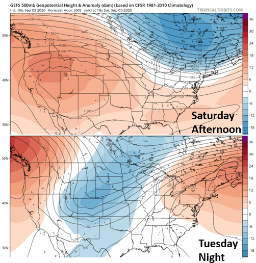
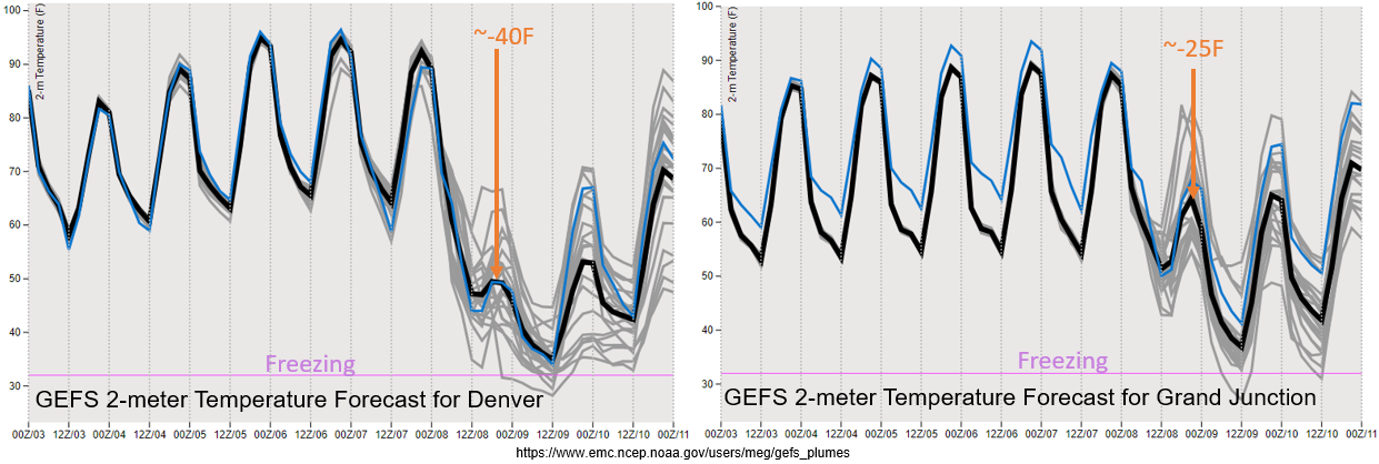
Just wanted to show how strong this change is going to be. The 500mb height anomaly from the GEFS is below. On top is Saturday afternoon and on the bottom is Tuesday night. Basically, we go from a really strong ridge (hot temperatures) to a strong, positively tilted trough (very cold temperatures). Below the 500mb height anomalies is the 2-meter temperature for Denver (left) and Grand Junction (right). After the cold front passes through, the high, average temperature over Denver drops about ~40F! While the drop in temperature isn’t quite as strong over Grand Junction, the change in the afternoon high temperature is still about ~25F after the front passes through. This cold snap could bring the snow line down to about ~6500 feet, but of course a lot can change in the details by next week. As we near the event, the final solution should become a bit clearer, so we’ll continue to watch model trends over the weekend and report back on Monday. The cooler temperatures only hang around for a couple of days before more seasonable temperatures return to the forecast.
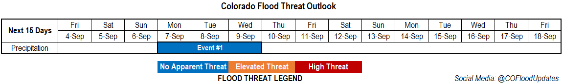
Event #1: Monday – Wednesday (9/7 – 9/9)
No Apparent threat as a cold blast returns precipitation chances early next week.
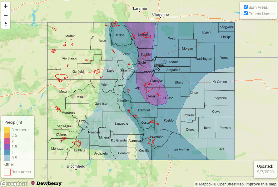
The large portion of the event should occur late Monday night into Tuesday. Residual moisture may allow for a couple scattered storms over the mountains on Wednesday if subsidence isn’t too strong behind the departing trough. As the front passes through, expect some very strong wind gusts due to the tight surface gradient. For the most part, the rainfall should be gradual enough (stratiform) that flooding should be avoided for the lower elevations. With snow in the mountains forecast, not thinking this will cause any flooding concerns either. The real question is how low the snow line will drop. It’s likely that there could be some snow accumulation over the Palmer Ridge if the event follows the latest GFS runs. The European model is a bit warmer, but still showing snow for most of the high elevations, which includes the foothills. If the precipitation continues into Wednesday and Thursday, like the European model suggests, there will likely be a transition back to rainfall with only the highest peaks experiencing snowfall for the full period. In that case, there is a slight chance for some rain on snow (increased runoff), but at this time there is No Apparent flood threat. The precipitation map below is the best blend of model solutions that I could come up with. Be sure to tune back in on Monday for the latest.