Issue Date: Monday, September 7th, 2020
Issue Time: 2:15PM MDT
Valid Dates: 9/8– 9/22
It’s time for the winter weather alarm to be officially sounded! A big change is on the way tonight as an upper trough digs south and turns the upper flow southwest, but not before another day of above average temperatures and dry conditions. While it’s pretty great BBQ weather for Labor Day, it will be a bit smoky with the HRRR smoke showing a lot of near surface smoke across the state. This evening the cold front rushes across the northern border, which will likely produce some strong wind gusts (up to 60 mph) as it passes overhead and moves south. Behind the front, a large temperature drop is expected along with the beginning of the precipitation. Expect precipitation first over the Front Range, Urban Corridor, and Northeast Plains, and then over the Northern Mountains and Northwest Slope. Over the highest terrains, the crossover from rain to snow will occur first, and pretty quickly, while the lower elevations should crossover sometime late tomorrow morning after some extra evaporative cooling. With non-frozen soils, warm cement, and heavy snow (low liquid to snow equivalent), the snow totals may be a bit lower than they would typically be. This is especially true over the lower elevations.
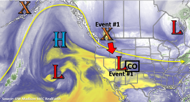
Tomorrow morning, the precipitation is expected to expand southwards, first over the eastern high terrains and then over the western Colorado. At the same time, the snow line will drop in elevation leaving roads slick. This is also when the trough strengths and becomes a cut off low over Utah (shown in the map below). It will rotate over the region for a couple of days before lifting to the northeast Thursday night into Friday. This should keep precipitation in the forecast through Thursday. By Wednesday evening, expect the transition from snow back to rain as temperatures increase slightly over the lower elevations.
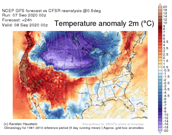
Below is the GFS temperature forecast for 6PM tonight. You can see the above average temperatures over the state today, but also the cold front at the northern border. Behind the front, temperatures drop to well below normal. By tomorrow afternoon, highs will be well below normal with most areas of the state >20F below normal for early September. The earliest snowfall for Denver was September 3, 1961, so we won’t be breaking that record. Temperatures should remain warm enough over the Grand Valley that only rainfall is anticipated at this time. A freeze warning is in effect for the Northeast Plains, Palmer Ridge, Upper Yampa River Basin, and San Luis Valley/Raton Ridge (below 8500ft) from Tuesday into Wednesday. Be sure to follow your local NWS office for the latest on these warnings. With below freezing temperatures anticipated for Tuesday and Tuesday night along the I-25 corridor (30F or slightly less), you might want to drain or cover your sprinkler system and cover your garden.
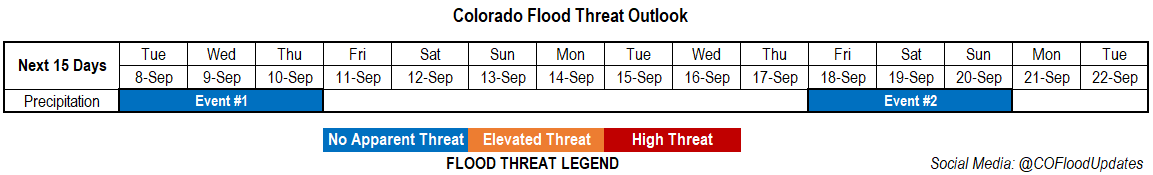
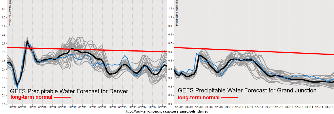
There looks to be a slight drop in PW values across the state behind the front before the Low draws some more moisture back into the state. So, expected a decrease in precipitation coverage starting Tuesday night (east) and Wednesday morning (west). On Wednesday and Thursday, snow and rainfall will be more limited in coverage, and by Thursday the plains will likely transition back into rainfall. The snow and stratiform precipitation mean there is No Apparent flood threat as precipitation will be rather gradual. It dries out and warms back up for the weekend, and rainfall chances don’t return for quite some time (Event #2). Low confidence in Event #2 occurring, and won’t mention more than just – it will be awhile before the next round of precipitation.
Event #1: Tuesday – Thursday (9/8 – 9/10)
No Apparent threat as very cold temperatures filter in from the north and an early season snowfall occurs.
As far as snow totals go, it’s a tough forecast with the snow to liquid ratio, timing of the crossover from rain to snow, and warm ground. Generally, I think we’re looking at totals below with snow bands producing some localized higher totals:
- 1-3” for the Urban Corridor
- 4-6” for the western Palmer Ridge/Raton Ridge
- 7-12” for the Front Range/Southeast Mountains
- 6-10” for the San Juan Mountains
- 6-10” for the Central Mountains (more isolated)
- 5-9” for the Northern Mountains (very isolated and north)
- 2-4” for the Northwest Slope (highest elevations)
- 1-3” for the San Luis Valley
- 0-2” for the Northeast Plains (decreasing further east)
- No snowfall for the Grand Valley, Southwest Slope, & Southeast Plains
As far as impacts, with vegetation still on the trees, broken limbs and power outages will be possible. For roads, it could get slushy and icy at first with more snow accumulating on the roads in the mountains on Tuesday. Wednesday’s commute for the Urban Corridor/Palmer Ridge will probably be a little worse than Tuesday. Freezing temperatures will likely damage crops and gardens, and frozen sprinkler lines will be possible. Additionally, snow could be heavy at times (under the snow bands), and increased surface winds could cause some limited visibility. One good thing to come out of the event will be increased fire containment. The last couple dry and windy days have not been good, especially for the Pine Gulch fire up north.