FTO 05-13-2021: Severe Weather Threat East, Then Return to More Widespread Precipitation

Issue Date: Thursday, May, 13th, 2021
Issue Time: 1:40PM MDT
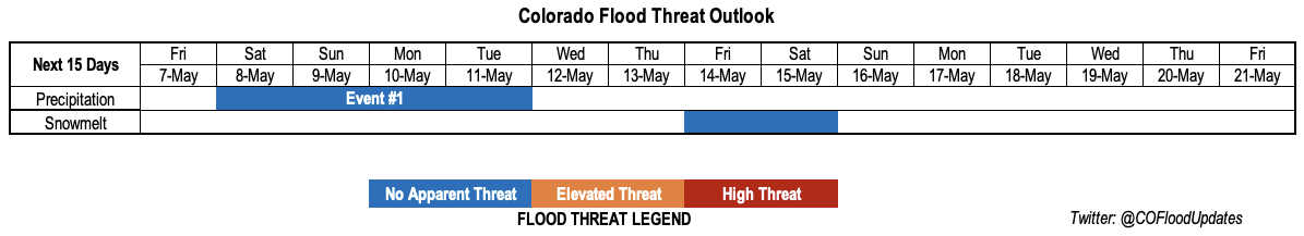
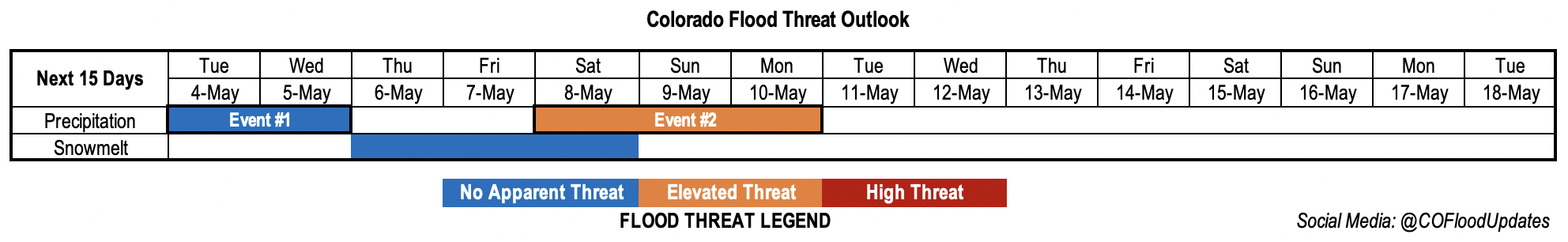
Valid Dates: 5/14 – 5/28

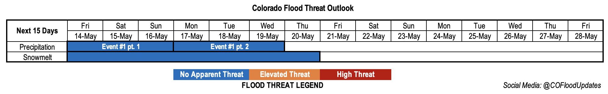
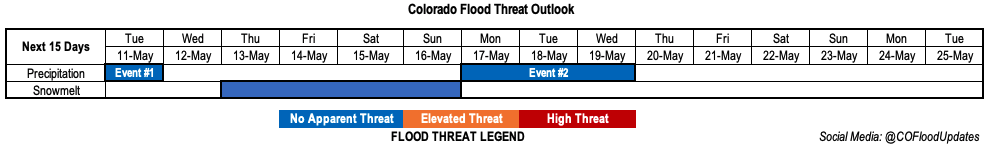
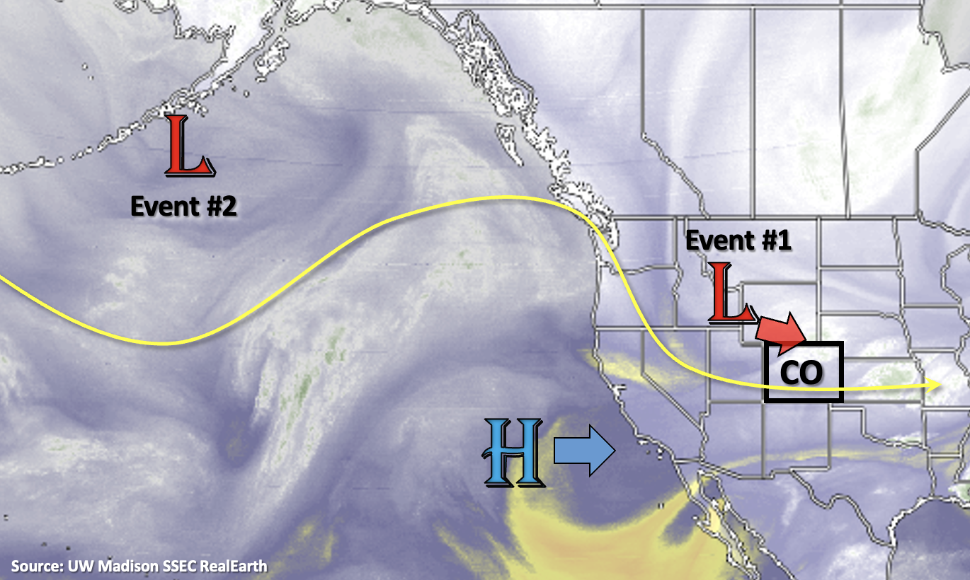
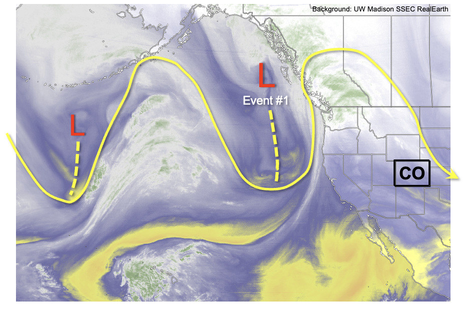
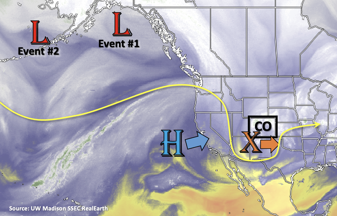
Active weather continues for this next forecast period with Event #1 being broken down into two parts. The first part of the event occurs tomorrow into this weekend as a cutoff Low develops and moves inland over California. During that period, a weak, broad ridge will be in place over Colorado. Although western Colorado will remain dry, eastern Colorado, particularly the eastern plains, has a chance for severe weather each afternoon. Part 2 of Event #1 occurs late Sunday into next week as the Low moves into the Four Corners region. Starting Monday, strong upslope flow, decent moisture and mid-level energy will be in place across the state bringing widespread showers with embedded convection. This system is forecast to be a warmer than the last two, so expect precipitation to fall as rain except for the very highest elevations.

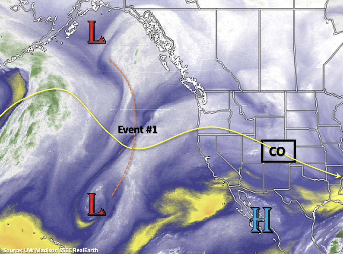
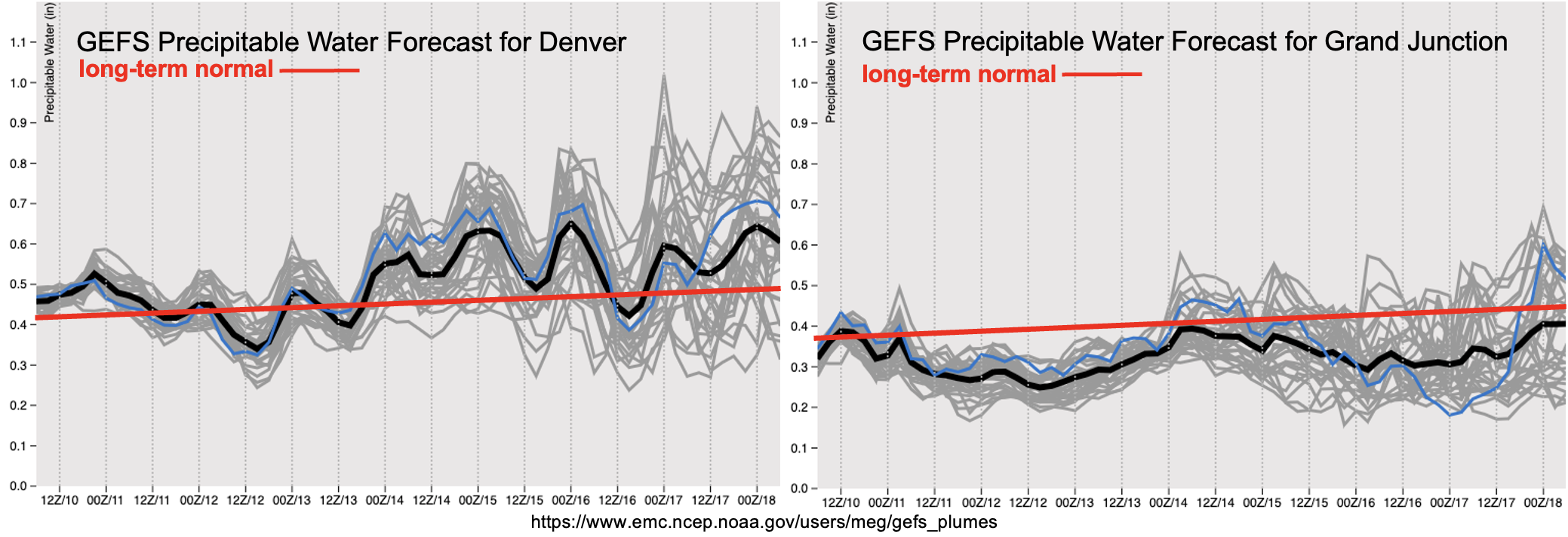
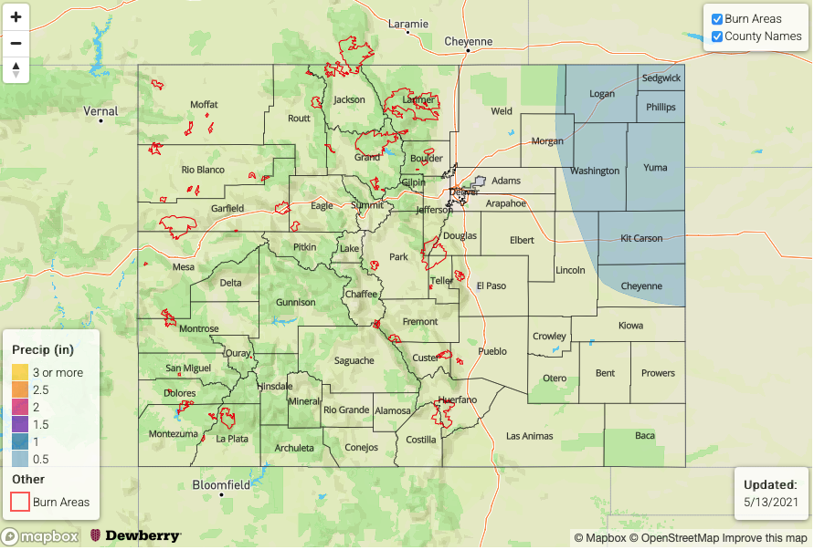
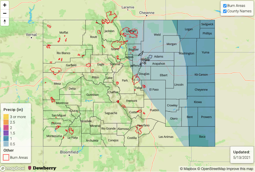
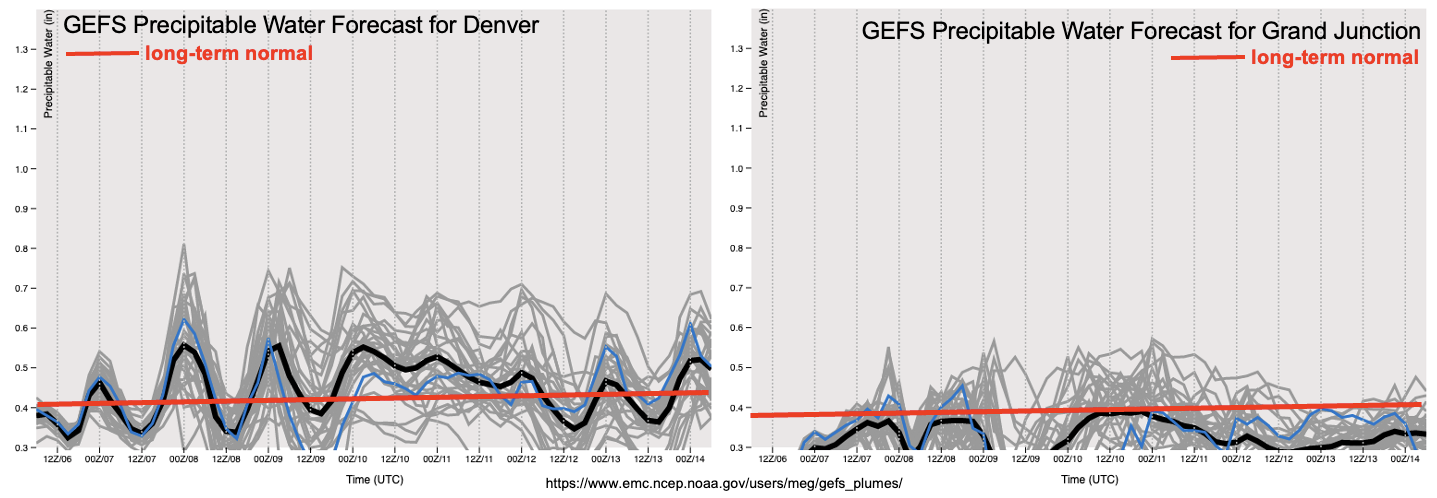
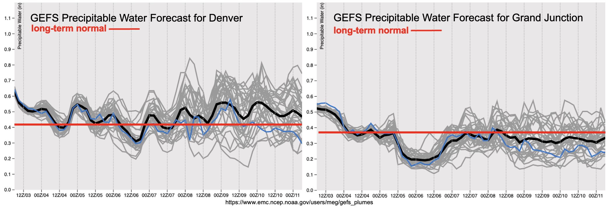
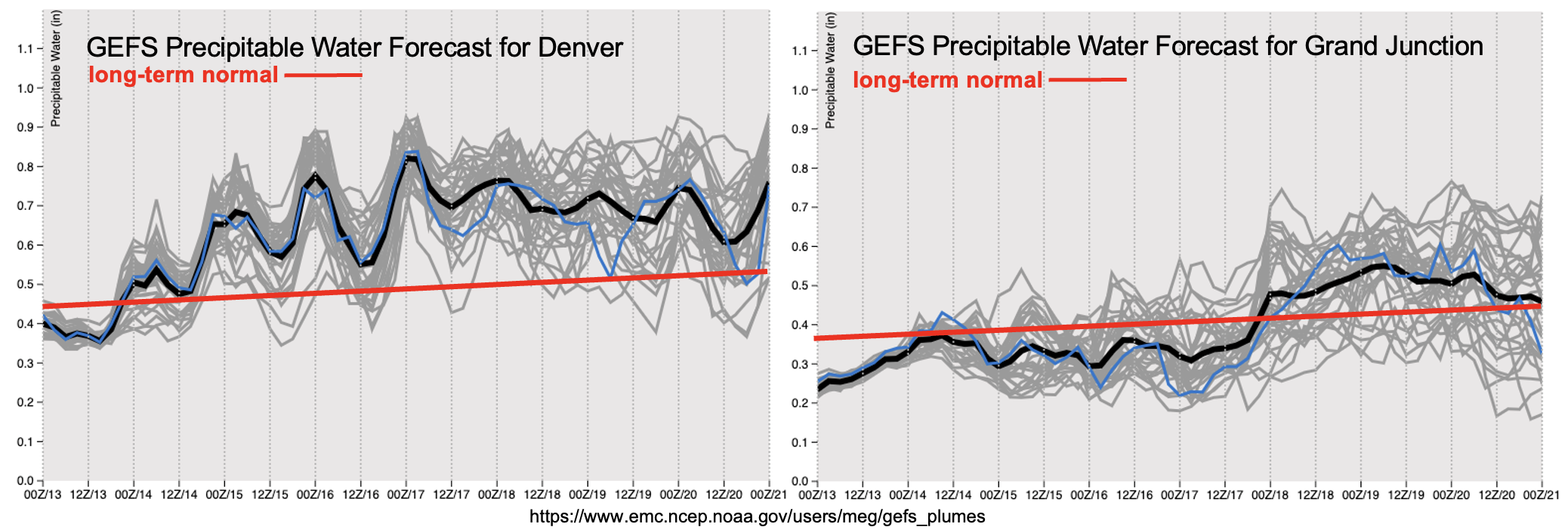
The GEFS really ramps up moisture over eastern Colorado from tomorrow afternoon through next week as does the EPS, but to a lesser extent. Until the Low makes its way into the Four Corners region, western Colorado will likely stay dry. With PW remaining under 1 inch (Denver) for part 1, flooding is not expected with storms that fire over the eastern mountains. However, a stronger thunderstorm over the adjacent plains may produce some brief, heavy rainfall if steering flows remain light. For part 2 of the event, more stratiform rainfall is expected. There is No Apparent flood threat due to soils having some time to dry out between systems and PW values well under an inch. However, burn areas will be watched closely for embedded convection each afternoon.

Streamflow:
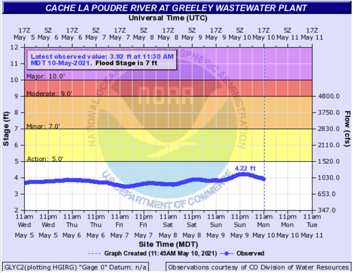
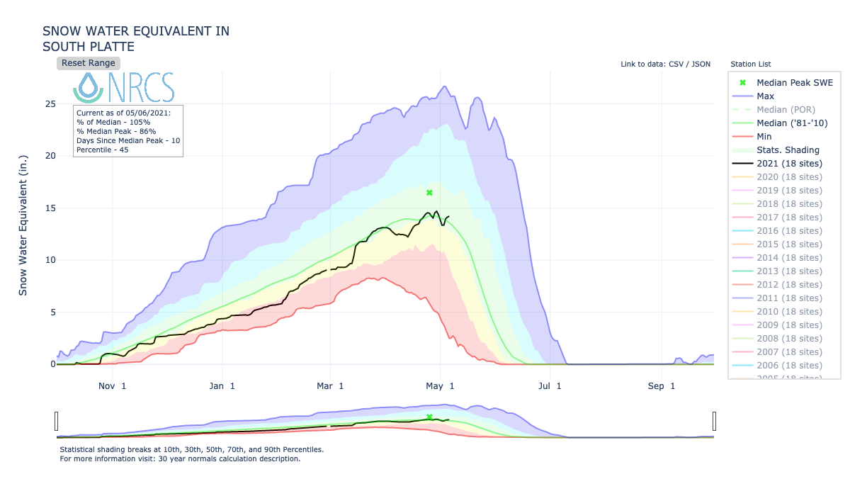
Between warmer temperatures and the possibility of a little rain on snow, increased flows are forecast across for rivers and local streams through next week. At this time, flows across major rivers are low enough that flooding is not expected. However, bankfull conditions are possible on smaller creeks and streams through next week. Especially if embedded convection occurs over the same area for a couple days in a row. To report any local stream flooding this spring, be sure to use our Report a Flood page.

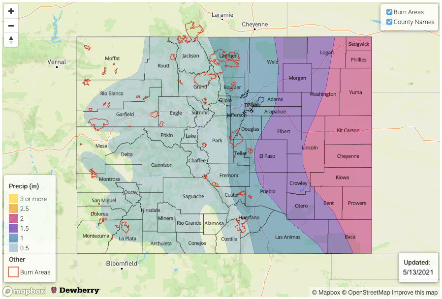
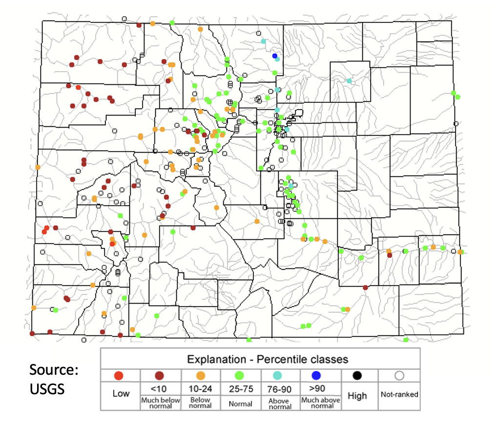
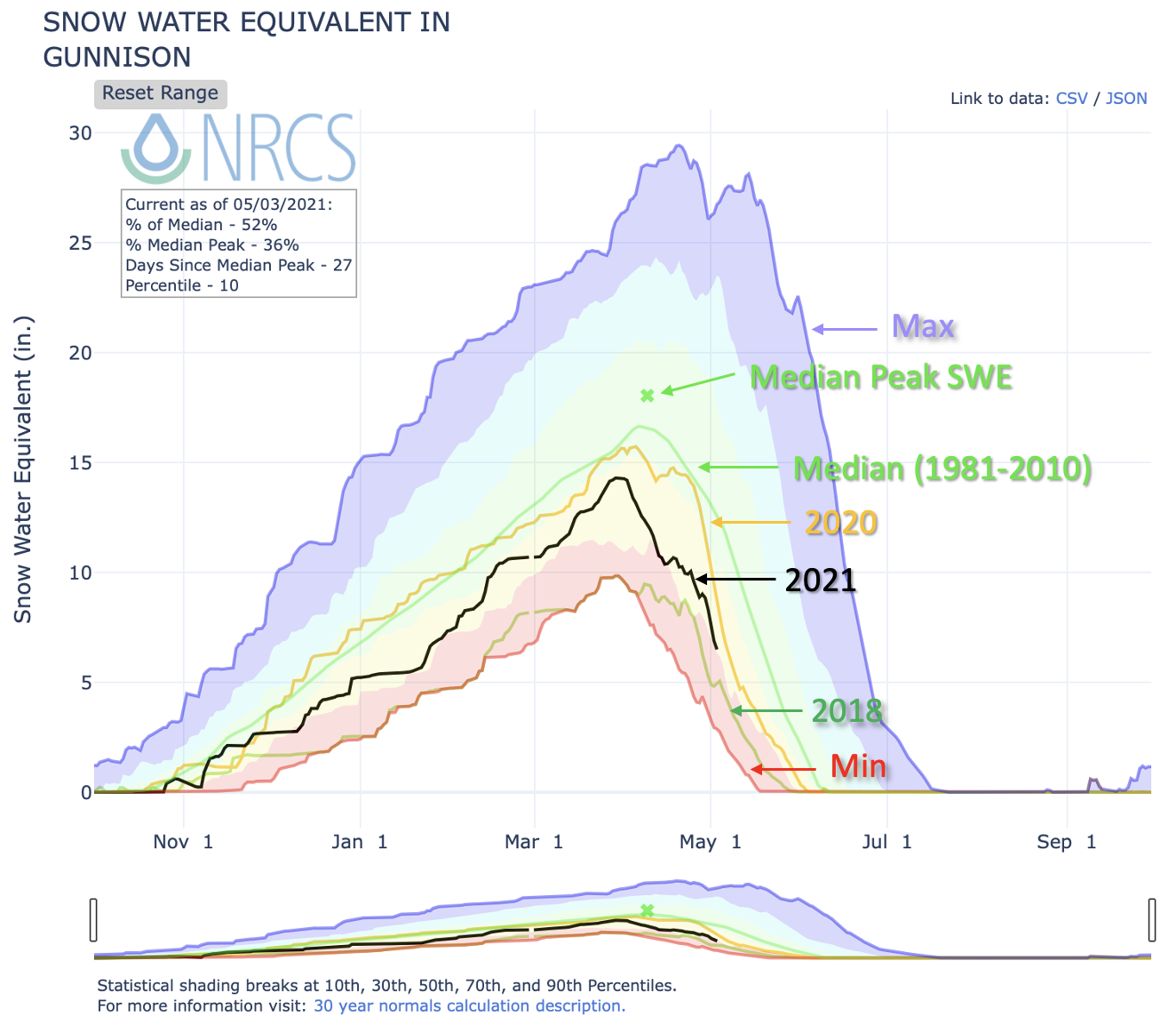
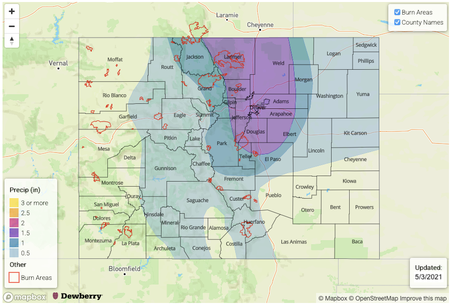
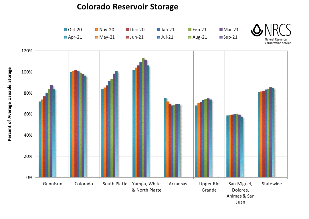
Below is the always important reservoir storage across the major basins and statewide. Although April is not quite as informative as May and June, below is a quick look at where we are starting at the beginning of this warm season. In April, all basins except the South Platte and Arkansas experienced deficits in their average usable storage. Reminder that except for the Northeast Plains, precipitation was below normal in April. However, the Gunnison, Colorado and Yampa/White/North Platte basins all remain above 80% of average usable storage. As far as flow forecasts for the major rivers, west of the Continental Divide, volumes are expected to be ~40-60% of normal, which is expected to put additional stress on the reservoir storage. East of the Divide, flow volumes are forecast to be about ~70 to 100% of normal, so less stress the reservoir storage is expected. Unfortunately, the last couple of systems created a precipitation surplus mainly over the Front Range and eastern plains, so dry conditions and likely more water use will continue over western Colorado.

Event #1: Friday – Wednesday (5/14 – 5/19)

No Apparent flood threat – first for severe storms over eastern Colorado, then for the more widespread precipitation event.

Finally, it’s time for severe weather season to kickoff. While there’s a chance for a severe storm or two along the dryline that develops over the eastern plains tomorrow, lack of large-scale lift may prevent storms from breaking the cap. The better chance for severe storms will be on Saturday afternoon as more mid-level energy, shear and moisture are present. Expect storms to develop over the Front Range and Southeast Mountains during the early afternoon and push into the adjacent plains where they will meet better moisture and dynamics. The main threats from storms will be large hail, strong winds, brief heavy rainfall and perhaps a weak tornado. At this time there is No Apparent flood threat but local heavy downpours may be possible. Be sure to tune back into the FTB each morning for the latest details.

Upslope flow picks up on Sunday into Monday, which will produce more widespread precipitation through Wednesday. The majority of the precipitation should fall as rain except for the highest peaks. Prolonged rain and embedded convection could cause some issues over the burn areas, so be sure to check the FBF each morning. Elsewhere, rainfall should be gradual enough that flooding is not expected, especially with the spring green-up. Thus, there is No Apparent flood threat issued.

FTO 05-10-2021: One More Day of Precipitation Before It Begins to Warm Up & Dry Out

Issue Date: Monday, May, 10th, 2021
Issue Time: 2:45PM MDT
Valid Dates: 5/11 – 5/25

The Low that has been influencing Colorado’s weather the last couple days will continue to do so for one more day on Tuesday (Event #1). This system is expected to track through the state tomorrow, which will continue snow at the higher elevations early on Tuesday and help produce rain over the eastern plains. Behind this system, a weak but broad area of High pressure is forecast to fill in over the state, which will help dry things out and warm up temperatures by the week’s end. Outside of some weak scattered thunderstorms over the weekend, it should be fairly dry. By early next week, it looks like some energy pinches off from the trough currently over the Pacific, which will bring another couple days of cooler temperatures and rainfall to Colorado (Event #2).

PW values will start to drop off to average or slightly below average from west to east beginning overnight. This paired with more stratiform precipitation tomorrow means that there is No Apparent flood threat issued. As a broad ridge builds in from the west, a drier airmass fills in which will reduce the precipitation chances by the end of this week and over the weekend. Quite a few differences in the evolution and location of the cutoff Low for Event #2, but it looks like PW and rainfall chances will be on the rise as the system moves into the Desert Southwest early next week. Expecting a slight cool-off with the system and precipitation accumulation to be mostly east of the Continental Divide.

Recent posts have been talking about the above average snowpack for the South Platte River Basin and the concern for high flows along the Cache La Poudre River. That region has received more precipitation over the last 48-hours (plus today). By Friday afternoon, temperatures are forecast to rebound to 5 to 10 degF above average. So, the slightly elevated flow (shown below) paired with increasing temperatures by this weekend could mean that the streamflow gage near Greeley may come close to or reach into the Action stage. Minor flooding is not anticipated at this time, so there is No Apparent flood threat for runoff. Other gages in the area are running in the 76th to 90th percentile with the majority of the gages along the front range and eastern plains in the 25th to 75th percentile. These early season cold snaps wedged between longer warm periods really help to temper the runoff.

Event #1: Tuesday (5/11)

No Apparent flood threat as stratiform rainfall tapers off from west to east over the next 24-hours.

Rainfall should be mostly confined to the eastern plains by tomorrow afternoon. However, some snow will be possible over the Northern Mountains and Front Range as the Low moves overhead. Additionally, in the morning, snowfall could impact the commute along the I-25 corridor due to the snowline dropping overnight. By early evening, instability should drop off along with upper dynamics, so precipitation is forecast to taper off. Totals around 0.50 inches will be possible over the Northeast Plains, indicating that there is No Apparent flood threat.

Event #2: MondayWednesday (5/17 – 5/19)

No Apparent flood threat as the next cutoff Low moves into the Desert Southwest.

Still quite a bit of differences between models and runs for Event #2, but it looks like the next system will move in at the start of next week. As far as totals, going with the slightly drier solution produced by the European model. Overall, it looks like a slight cool-down to start the week, but not quite as cool as these last two systems. Rainfall will general be focused over the mountains and east of the Continental Divide. Heavier rainfall looks be located over the eastern plains and some stronger thunderstorms are possible if a shortwave passes at peak heating. It’s a bit too far out to nail down these details, so be sure to tune back into the FTO on Thursday for the latest. Summer-like temperatures and dry conditions are forecast over western Colorado.

FTO 05-06-2021: A Cool Spring Continues With Another Round Of Prolonged Rain And Snow

Issue Date: Thursday, May 6, 2021
Issue Time: 2PM MDT
Valid Dates: 5/7-5/21

From a climatological perspective, the months of April and May are some of the most volatile for Colorado. Not only are there very large variations of precipitation and temperature at a given location during this time of year, but there is also drastic variation across the state at any given point in time. For example, the map in the Tweet below shows that climatologically, May is the wettest (and snowiest) month of the year for parts of the Front Range and Urban Corridor, while it is nearly the driest time of year for the southwest parts of the state (source: Brian Brettschneider, Twitter; @Climatologist49).

As shown in the water vapor imagery, below, we continue to see Colorado in the midst of a very active string of disturbances stretched across the eastern Pacific all the way into the eastern United States. As is quite common this time of year, these disturbances will continue to have a propensity to cut-off from the larger jet stream. This will first occur with the trough currently just off the northwest US coast, followed by a secondary disturbance that will reinvigorate the initial cut-off. In short, this will cause a prolonged 72-96 hour stretch of multiple precipitation events for most of the state.

Once again, the northeast quadrant of the state will likely collect the most precipitation, both in the form of rainfall and snowfall. However, almost the entire state will receive some measurable precipitation, with the possible exception parts of the San Luis Valley and lowest elevations of the Southwest Slope. Fortunately, we are currently seeing No Apparent Flood Threat with this event, given the general lack of atmospheric instability. As seen in the forecast PW plumes below, maximum values are expected to stay below 0.75 inch in Denver, which coupled with limited instability is not enough to cause concerns for heavy rainfall.

After Event #1 comes to an end during the middle of next week, we expect a quick rebound in temperatures to above normal level by Friday, May 14. This will cause a shift in attention to the snowpack for possible issues with snow melt. Unfortunately, as covered widely by local media, most of Colorado currently has below normal snowpack, thus limiting concern for snowmelt-induced runoff. However, one stark exception to this is the South Platte River basin, as shown below. Here, we see a snowpack that is just above normal for this time of year, with a further separation above normal expected due to the upcoming storm.

It is important to note that the image above is somewhat misleading, because it is derived by averaging many sites together including lower elevation ones that usually melt out earlier. If we focus on only higher-elevation SNOTEL sites, like Willow Park below, we see that deviations above normal are notably larger. For example, Willow Park is currently about 35% above the seasonal median, which could increase to 50-70% above median after the next precipitation event. This, coupled with the expectation of above normal temperatures by late next week means we will be watching out for snowmelt-induced flooding, most notably in the Big Thompson and Cache La Poudre basins.

Below, the Event #1 is outlined in greater detail.

Event #1: Saturday – Tuesday (5/85/11)

No Apparent Flood Threat as a couple shortwaves move through the flow and produce storms with residual moisture.

This event could begin as early as Friday afternoon with isolated showers and weak thunderstorms for parts of the southern Colorado, but will begin in earnest on Saturday. Multiple rounds of showers, with embedded thunderstorms are expected from Saturday through Tuesday. The highest thunderstorm coverage is expected on Saturday, with the availability of atmospheric instability. Strong-to-severe thunderstorms are possible in the Southeast Plains, towards the Kansas border. Reduced thunderstorm coverage is expected starting on Sunday, onwards, however, it is possible that the far southeast parts of the Southeast Plains could see another round of strong storms during the afternoons of Sunday-Tuesday. Over the course of the event, maximum one hour rainfall up to 0.7 inches is expected above 5,000 feet, with intensity up to 1.1 inch possible towards the Kansas and Nebraska borders. However, the duration of intense rainfall is expected to be too short and spatially confined to warrant a flood threat.

The snow level will begin above 8,000 feet on Saturday and gradually lower and oscillate between near 5,500 feet at night and 8,000 feet during the day beginning Sunday.

In all, isolated locations along the Front Range could see 2 inches to perhaps 3 inches of total precipitation from this storm. Because this will mainly be in the form of snow, flooding is not expected. A secondary maximum in precipitation, more associated with thunderstorms, is expected over the Palmer Ridge and Southeast Plains where total storm rainfall up to 2 inches could occur. However, given the spread out duration of this event and relatively low duration of high intensity rainfall, flooding is not expected.

Five of the six fire burn scars monitored by the Fire Burn Forecast page lie in high elevations and are not expected to be under threat for this event. However, we will be watching the Calwood burn scar, which sits between 6,000 and 7,000 feet in elevation, for possibly minor flooding concerns on Saturday.

FTO 05-03-2021: On and Off Precipitation Through Next Week

Issue Date: Monday, May, 3rd, 2021
Issue Time: 3:15PM MDT
Valid Dates: 5/4 – 5/18

The current shortwave affecting yesterday and today’s weather is marked with an orange “X” in the water vapor imagery below. As this system moves eastward, the High pressure system to our west will begin to build into the state, which will turn the steering flow more northwesterly. This will allow some mid-level energy to move through the flow tomorrow and Wednesday, which will likely produce scattered precipitation with the residual moisture.

On Thursday and Friday, the ridge should be fully intact overhead, bringing with it temperatures about ~10 degF above average and dry conditions. Snowmelt should increase during this 2 to 3 day warm period, before the next system (Event #2) propagates into the state sometime on Saturday. There is No Apparent threat for snowmelt during this period. Event #2 will again cool off temperatures and bring our next round of precipitation on Mother’s Day weekend.

PW values will begin to drop off from west to east as the current system moves eastward. Enough residual moisture looks like it will remain to help produce scattered storms over the Northern Mountains, Front Range and Central Mountains tomorrow. As the storms develop over the mountains and move southeast into the eastern plains, they could produce some dangerous lighting and brief outflow winds. However, there seems to be No Apparent flood threat at this time with PW values near average (Event #1). Looks like a bit of a rinse and repeat pattern for Wednesday.

Also shown nicely in the images below are the rapid drop off in available moisture (both east and west) as the ridge builds overhead on Thursday and Friday. With PW values likely dropping off to around 0.20 inches over western Colorado and surface winds picking up, there could be an increase in fire weather. By Saturday and Sunday, moisture looks to return behind a front. While there’s still quite a bit of spread in the amount of moisture that could become available, PW values on the higher end could mean a chance for severe weather and a flood threat over eastern Colorado. It’s still early in the season, so once Event #2 gets closer, precipitation type and amount will become clearer. An Elevated Flood threat has been issued for this event with eyes mostly on Monday.

There was a nice highlight of this season’s snowpack in Saturday’s SPM along with an update to the ongoing drought. Outside of the South and North Platte River Basins, snowmelt is well underway. Below is a look at SWE over the Gunnison Basin. Snowmelt here is looking a bit like 2018 and 2020, but with SWE amounts somewhere between these two years. The cooler temperatures today and next weekend may delay the snowmelt a bit, but overall, it’s look like full melt out will occur sooner than average. This is likely the case for most basins in the state. Streamflow will be interesting to watch this season due to very dry soils last fall. It is also likely that not all the melt water will make it into the major rivers.

Event #1: TuesdayWednesday (5/45/5)

No Apparent flood threat as a couple shortwaves move through the flow and produce storms with residual moisture.

Isolated precipitation totals may reach around 0.50 inches if storms are able to track over the same areas on Tuesday and Wednesday. With storm motion fairly quick to the southeast, local heavy rainfall is not anticipated at this time so there is No Apparent flood threat. As storms move off the Northern Mountains and Front Range, they may pick up in intensity over the eastern plains. The main threat from storms will be brief outflow winds, although they may produce some lightning and small hail as well. Severe storms are not anticipated at this time but check back in for full details in tomorrow’s FTB.

Event #2: Saturday – Monday (5/85/10)

Elevated flood threat with a cold front increasing moisture and dynamics and the possible development of a lee cyclone.

Low confidence in all the details this far out, but it looks like the next strong system will break down the ridge and move into the state at the end of next weekend. With it still being fairly early in May, it is fairly likely that there will be more snow with the system for the mountains. However, the snowline is hard to determine at this time. During the second half of this period, it looks like a lee cyclone could develop over the eastern plains. If this occurs, it could help pull in some higher moisture with easterly and southeasterly surface flow. This may lead to some severe weather with local heavy rainfall and more widespread precipitation for the mountains. Be sure to tune into the FTO on Thursday as details will no doubt change as there are large differences in the weather model ensemble members.