Issue Date: Thursday, May 6, 2021
Issue Time: 2PM MDT
Valid Dates: 5/7-5/21
From a climatological perspective, the months of April and May are some of the most volatile for Colorado. Not only are there very large variations of precipitation and temperature at a given location during this time of year, but there is also drastic variation across the state at any given point in time. For example, the map in the Tweet below shows that climatologically, May is the wettest (and snowiest) month of the year for parts of the Front Range and Urban Corridor, while it is nearly the driest time of year for the southwest parts of the state (source: Brian Brettschneider, Twitter; @Climatologist49).
Where is May the wettest or driest month of the year? Stations in dark blue are wettest in May compared to all other months. May is the driest month for stations in dark red. Note: uses 1981-2010 normals. pic.twitter.com/A7UqBE6GUY
— Brian Brettschneider (@Climatologist49) May 2, 2021
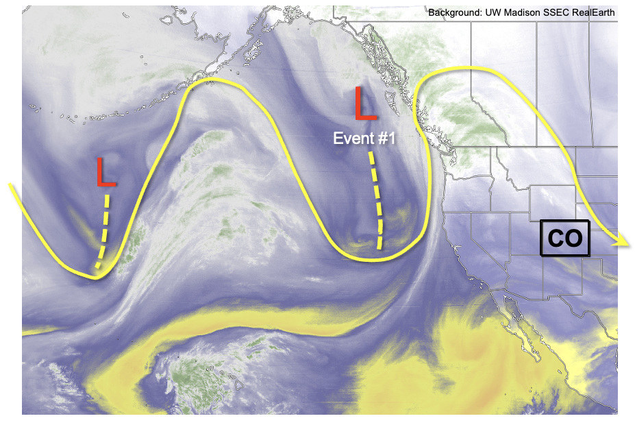
As shown in the water vapor imagery, below, we continue to see Colorado in the midst of a very active string of disturbances stretched across the eastern Pacific all the way into the eastern United States. As is quite common this time of year, these disturbances will continue to have a propensity to cut-off from the larger jet stream. This will first occur with the trough currently just off the northwest US coast, followed by a secondary disturbance that will reinvigorate the initial cut-off. In short, this will cause a prolonged 72-96 hour stretch of multiple precipitation events for most of the state.
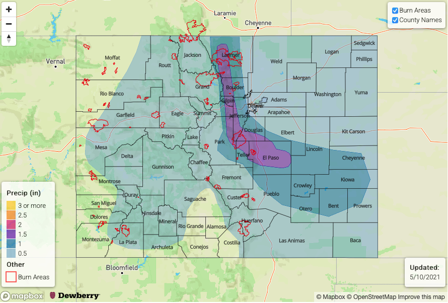
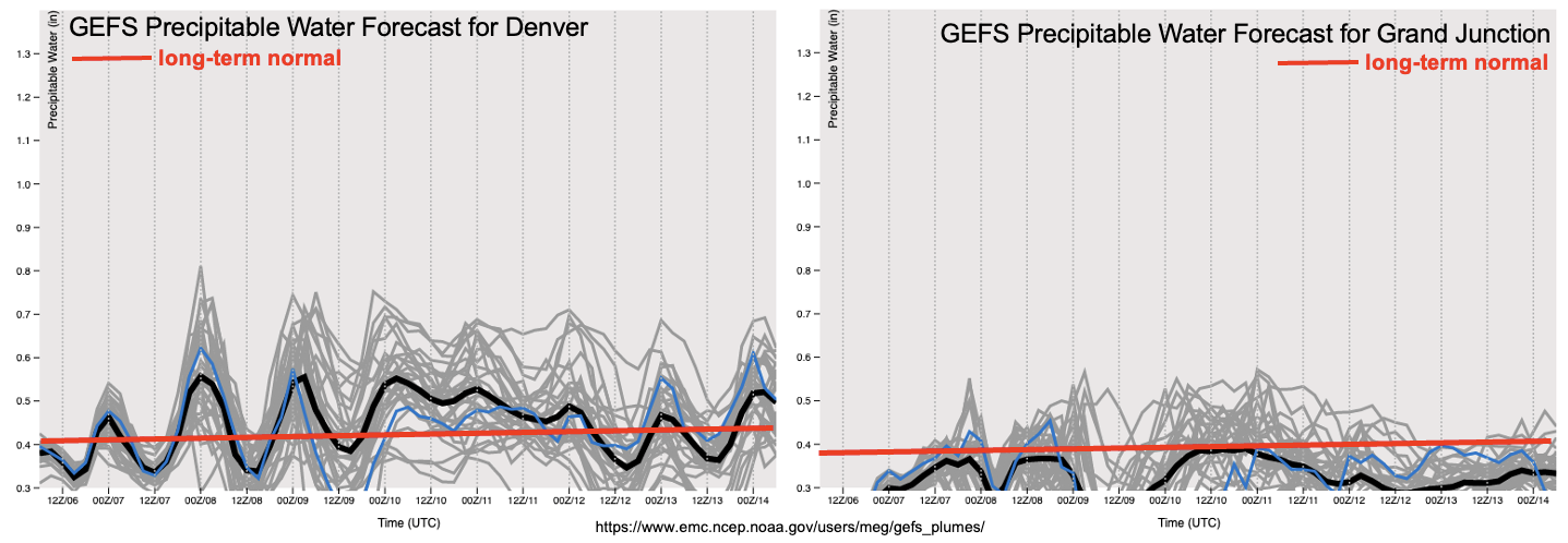
Once again, the northeast quadrant of the state will likely collect the most precipitation, both in the form of rainfall and snowfall. However, almost the entire state will receive some measurable precipitation, with the possible exception parts of the San Luis Valley and lowest elevations of the Southwest Slope. Fortunately, we are currently seeing No Apparent Flood Threat with this event, given the general lack of atmospheric instability. As seen in the forecast PW plumes below, maximum values are expected to stay below 0.75 inch in Denver, which coupled with limited instability is not enough to cause concerns for heavy rainfall.
After Event #1 comes to an end during the middle of next week, we expect a quick rebound in temperatures to above normal level by Friday, May 14. This will cause a shift in attention to the snowpack for possible issues with snow melt. Unfortunately, as covered widely by local media, most of Colorado currently has below normal snowpack, thus limiting concern for snowmelt-induced runoff. However, one stark exception to this is the South Platte River basin, as shown below. Here, we see a snowpack that is just above normal for this time of year, with a further separation above normal expected due to the upcoming storm.
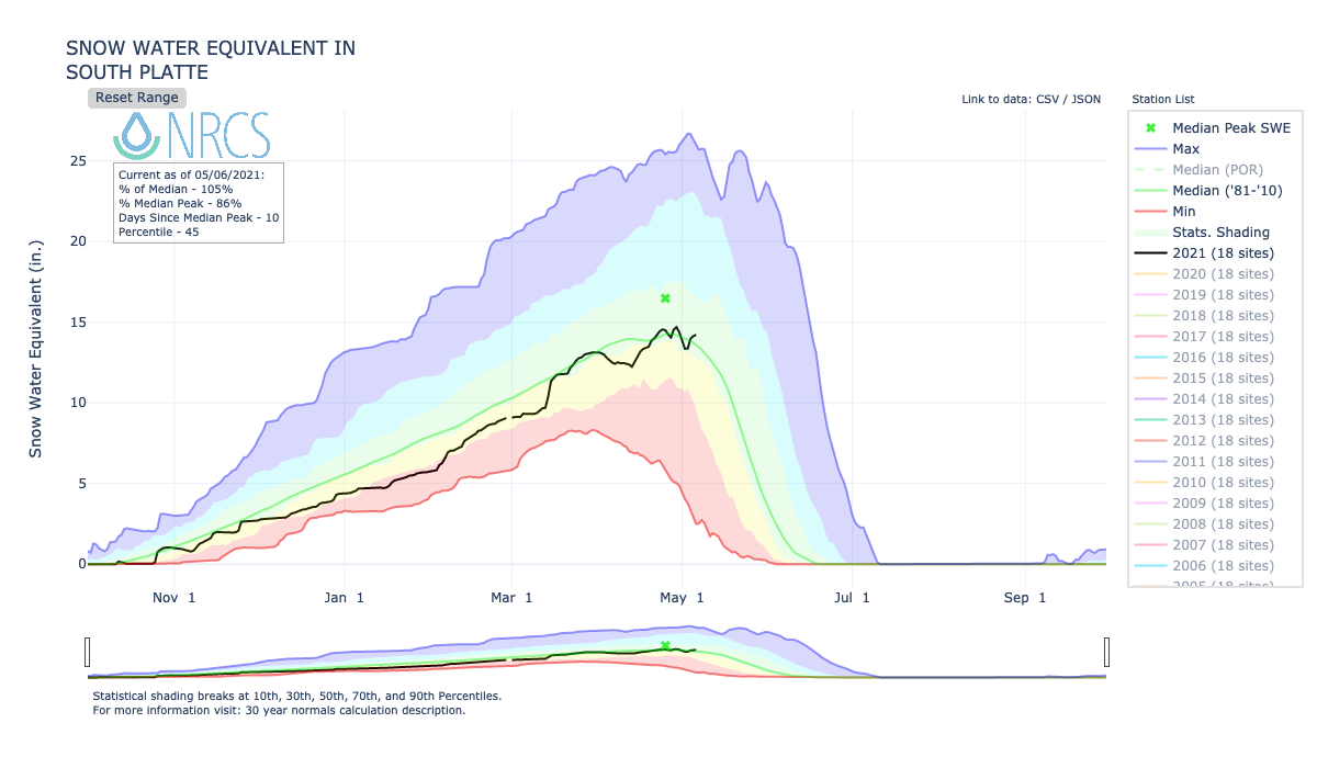
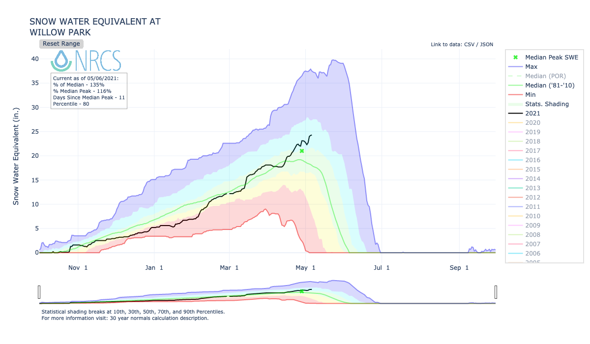
It is important to note that the image above is somewhat misleading, because it is derived by averaging many sites together including lower elevation ones that usually melt out earlier. If we focus on only higher-elevation SNOTEL sites, like Willow Park below, we see that deviations above normal are notably larger. For example, Willow Park is currently about 35% above the seasonal median, which could increase to 50-70% above median after the next precipitation event. This, coupled with the expectation of above normal temperatures by late next week means we will be watching out for snowmelt-induced flooding, most notably in the Big Thompson and Cache La Poudre basins.
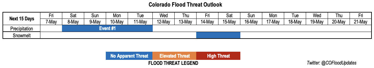
Below, the Event #1 is outlined in greater detail.
Event #1: Saturday – Tuesday (5/8 – 5/11)
No Apparent Flood Threat as a couple shortwaves move through the flow and produce storms with residual moisture.
This event could begin as early as Friday afternoon with isolated showers and weak thunderstorms for parts of the southern Colorado, but will begin in earnest on Saturday. Multiple rounds of showers, with embedded thunderstorms are expected from Saturday through Tuesday. The highest thunderstorm coverage is expected on Saturday, with the availability of atmospheric instability. Strong-to-severe thunderstorms are possible in the Southeast Plains, towards the Kansas border. Reduced thunderstorm coverage is expected starting on Sunday, onwards, however, it is possible that the far southeast parts of the Southeast Plains could see another round of strong storms during the afternoons of Sunday-Tuesday. Over the course of the event, maximum one hour rainfall up to 0.7 inches is expected above 5,000 feet, with intensity up to 1.1 inch possible towards the Kansas and Nebraska borders. However, the duration of intense rainfall is expected to be too short and spatially confined to warrant a flood threat.
The snow level will begin above 8,000 feet on Saturday and gradually lower and oscillate between near 5,500 feet at night and 8,000 feet during the day beginning Sunday.
In all, isolated locations along the Front Range could see 2 inches to perhaps 3 inches of total precipitation from this storm. Because this will mainly be in the form of snow, flooding is not expected. A secondary maximum in precipitation, more associated with thunderstorms, is expected over the Palmer Ridge and Southeast Plains where total storm rainfall up to 2 inches could occur. However, given the spread out duration of this event and relatively low duration of high intensity rainfall, flooding is not expected.
Five of the six fire burn scars monitored by the Fire Burn Forecast page lie in high elevations and are not expected to be under threat for this event. However, we will be watching the Calwood burn scar, which sits between 6,000 and 7,000 feet in elevation, for possibly minor flooding concerns on Saturday.