Issue Date: Monday, May, 3rd, 2021
Issue Time: 3:15PM MDT
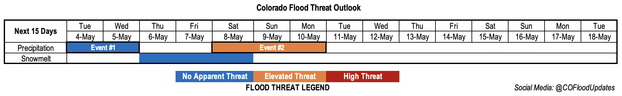
Valid Dates: 5/4 – 5/18
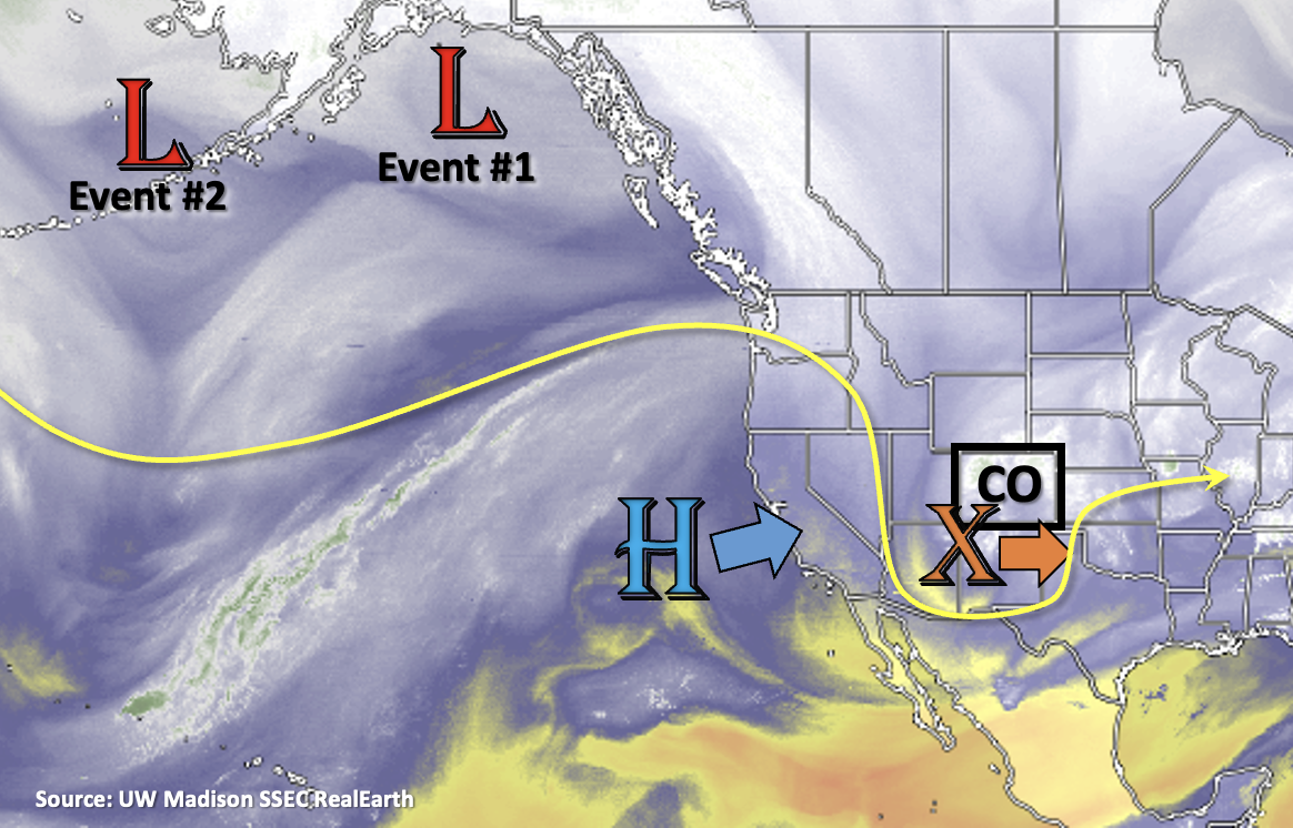
The current shortwave affecting yesterday and today’s weather is marked with an orange “X” in the water vapor imagery below. As this system moves eastward, the High pressure system to our west will begin to build into the state, which will turn the steering flow more northwesterly. This will allow some mid-level energy to move through the flow tomorrow and Wednesday, which will likely produce scattered precipitation with the residual moisture.
On Thursday and Friday, the ridge should be fully intact overhead, bringing with it temperatures about ~10 degF above average and dry conditions. Snowmelt should increase during this 2 to 3 day warm period, before the next system (Event #2) propagates into the state sometime on Saturday. There is No Apparent threat for snowmelt during this period. Event #2 will again cool off temperatures and bring our next round of precipitation on Mother’s Day weekend.
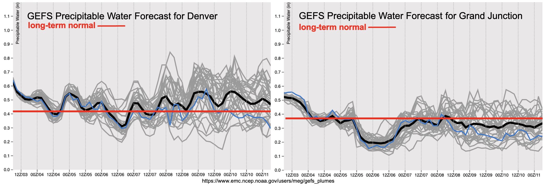
PW values will begin to drop off from west to east as the current system moves eastward. Enough residual moisture looks like it will remain to help produce scattered storms over the Northern Mountains, Front Range and Central Mountains tomorrow. As the storms develop over the mountains and move southeast into the eastern plains, they could produce some dangerous lighting and brief outflow winds. However, there seems to be No Apparent flood threat at this time with PW values near average (Event #1). Looks like a bit of a rinse and repeat pattern for Wednesday.
Also shown nicely in the images below are the rapid drop off in available moisture (both east and west) as the ridge builds overhead on Thursday and Friday. With PW values likely dropping off to around 0.20 inches over western Colorado and surface winds picking up, there could be an increase in fire weather. By Saturday and Sunday, moisture looks to return behind a front. While there’s still quite a bit of spread in the amount of moisture that could become available, PW values on the higher end could mean a chance for severe weather and a flood threat over eastern Colorado. It’s still early in the season, so once Event #2 gets closer, precipitation type and amount will become clearer. An Elevated Flood threat has been issued for this event with eyes mostly on Monday.
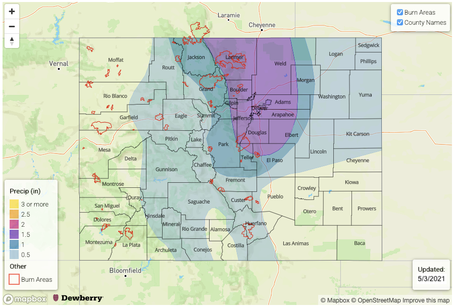
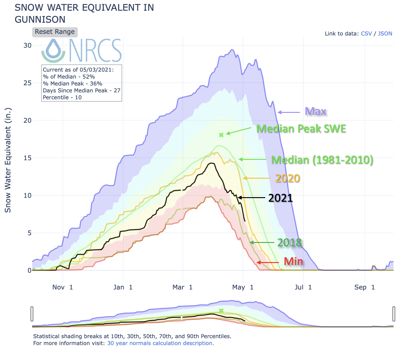
There was a nice highlight of this season’s snowpack in Saturday’s SPM along with an update to the ongoing drought. Outside of the South and North Platte River Basins, snowmelt is well underway. Below is a look at SWE over the Gunnison Basin. Snowmelt here is looking a bit like 2018 and 2020, but with SWE amounts somewhere between these two years. The cooler temperatures today and next weekend may delay the snowmelt a bit, but overall, it’s look like full melt out will occur sooner than average. This is likely the case for most basins in the state. Streamflow will be interesting to watch this season due to very dry soils last fall. It is also likely that not all the melt water will make it into the major rivers.
Event #1: Tuesday – Wednesday (5/4 – 5/5)
No Apparent flood threat as a couple shortwaves move through the flow and produce storms with residual moisture.
Isolated precipitation totals may reach around 0.50 inches if storms are able to track over the same areas on Tuesday and Wednesday. With storm motion fairly quick to the southeast, local heavy rainfall is not anticipated at this time so there is No Apparent flood threat. As storms move off the Northern Mountains and Front Range, they may pick up in intensity over the eastern plains. The main threat from storms will be brief outflow winds, although they may produce some lightning and small hail as well. Severe storms are not anticipated at this time but check back in for full details in tomorrow’s FTB.
Event #2: Saturday – Monday (5/8 – 5/10)
Elevated flood threat with a cold front increasing moisture and dynamics and the possible development of a lee cyclone.
Low confidence in all the details this far out, but it looks like the next strong system will break down the ridge and move into the state at the end of next weekend. With it still being fairly early in May, it is fairly likely that there will be more snow with the system for the mountains. However, the snowline is hard to determine at this time. During the second half of this period, it looks like a lee cyclone could develop over the eastern plains. If this occurs, it could help pull in some higher moisture with easterly and southeasterly surface flow. This may lead to some severe weather with local heavy rainfall and more widespread precipitation for the mountains. Be sure to tune into the FTO on Thursday as details will no doubt change as there are large differences in the weather model ensemble members.