FTO 05-27-2021: Another Prolonged Period Of Unsettled Weather, Then First Taste Of Summer Heat

Issue Date: Thursday, May 27, 2021
Issue Time: 1:30PM MDT
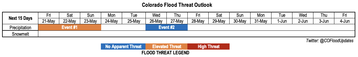
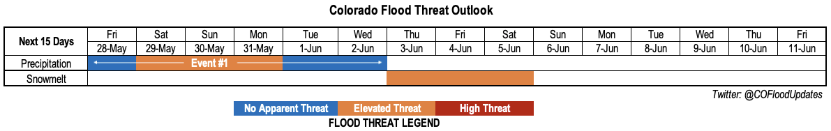
Valid Dates: 5/28-6/11

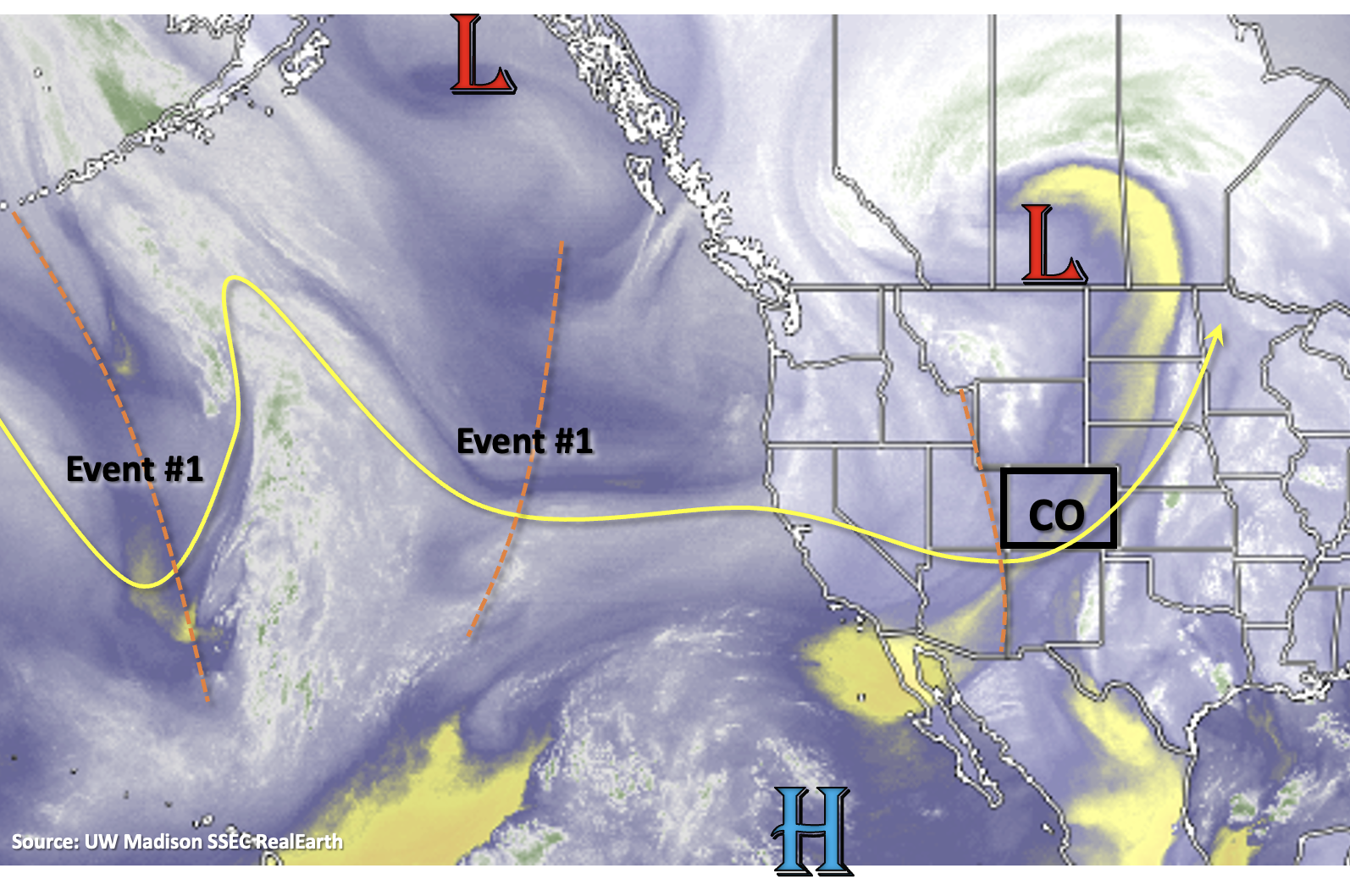
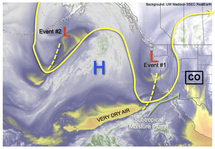
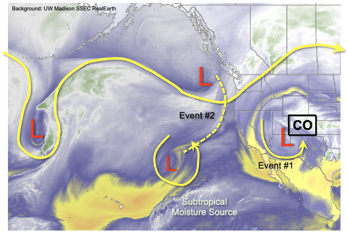
As shown in today’s water vapor image, below, a very active pattern remains in the eastern Pacific Ocean and western North America. The southward extent of the disturbances, and most notably the continued occurrence of cut-off circulations, is what makes this pattern a bit unusual for this time of year. Typically, late May is a time when the southwest United States upper-level ridge gradually begins to build in the lead-up to the monsoon season.

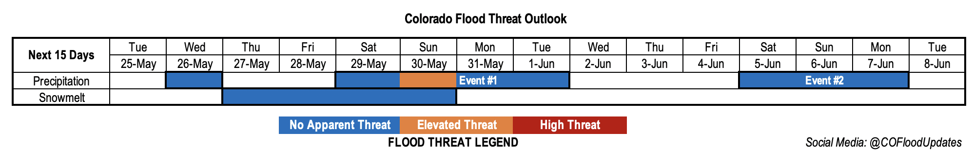
Beginning close to home, we see Colorado will be under a transient (i.e. passing) mid-level ridge, leading to excellent weather for most of the state. However, the next precipitation event, Event #1, will quickly be developing from two separate areas. An upper-level trough currently off the Washington state coast will move southeastward towards Colorado. This will cause synoptic-scale upward motion in the upper-levels, while steering a cold front across the state over the weekend. Meanwhile, the cutoff disturbance northeast of Hawaii will also gradually be picked up by the jet stream flow, prolonging the duration of unsettled weather mainly east of the Continental Divide.

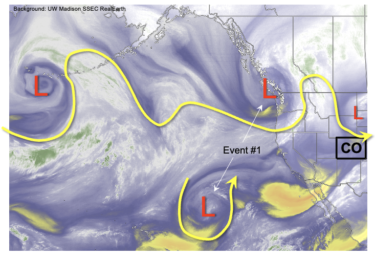
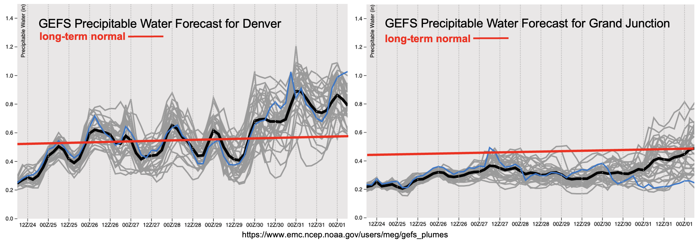
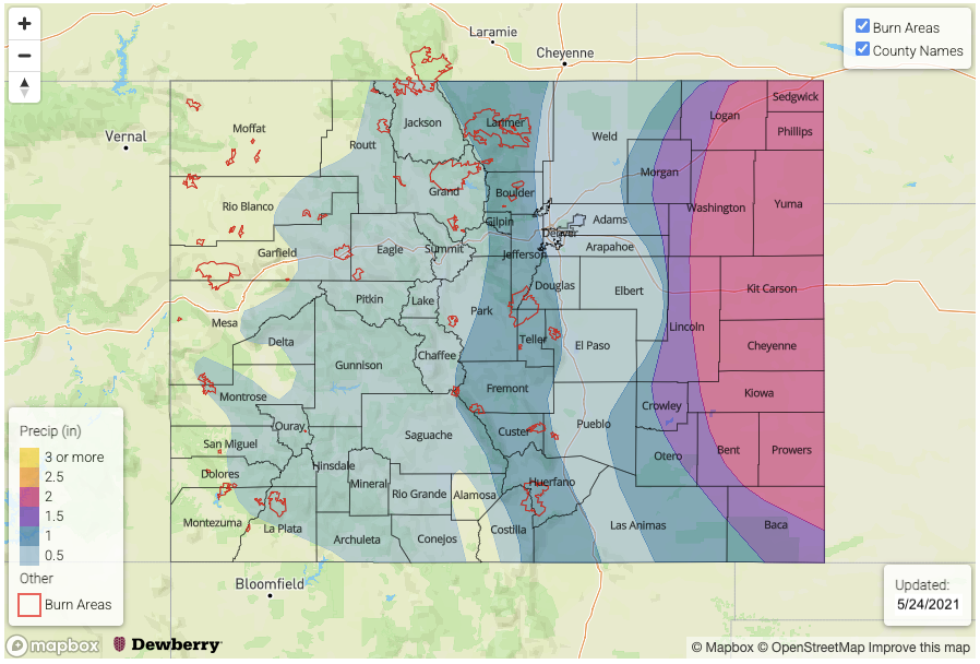
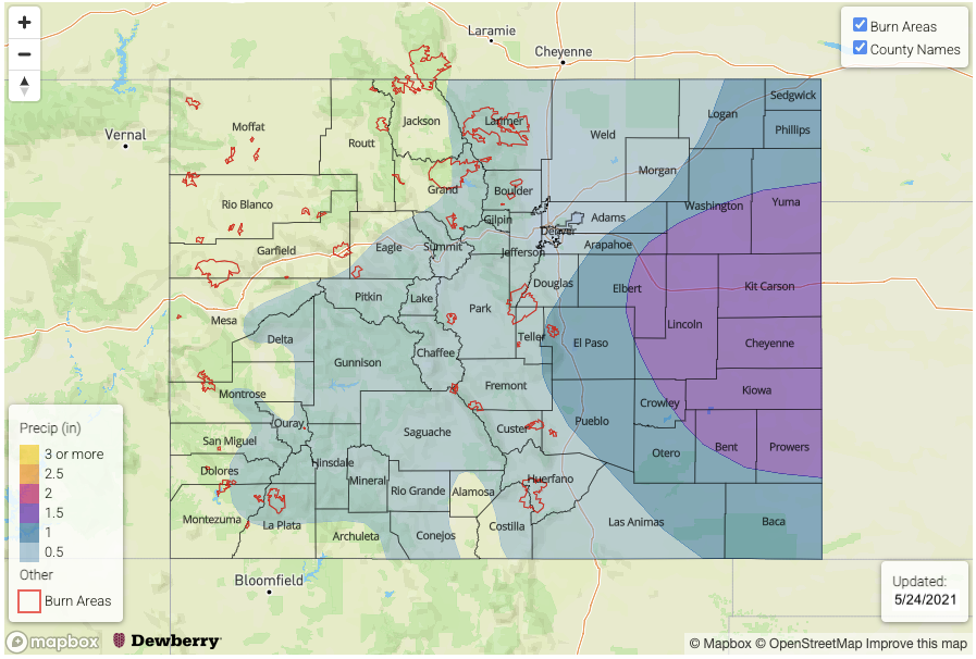
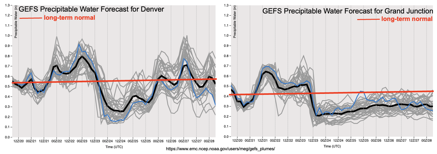
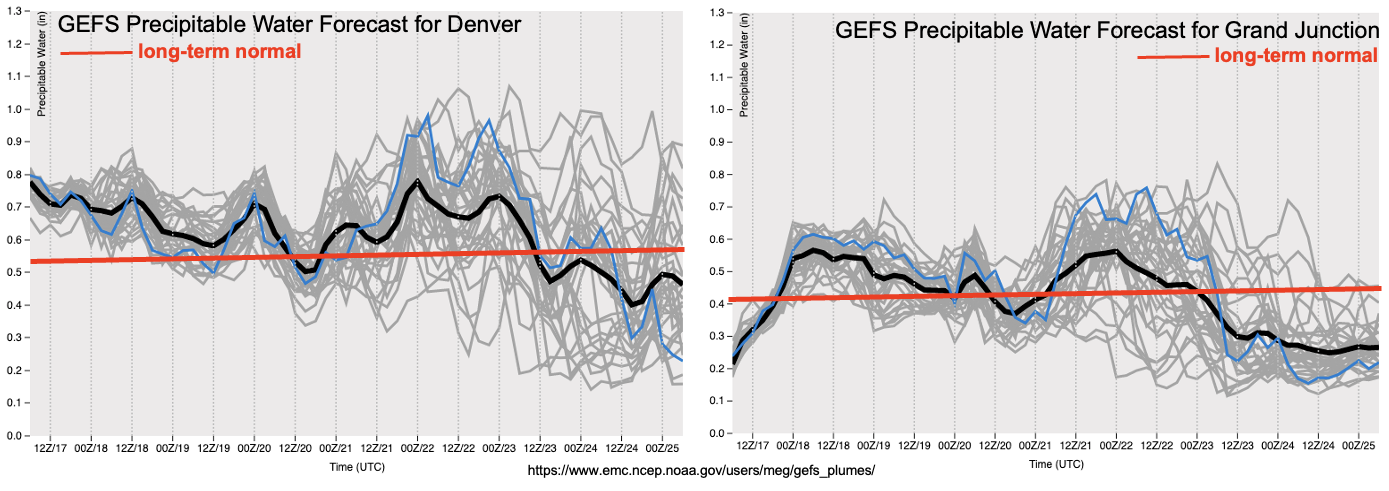
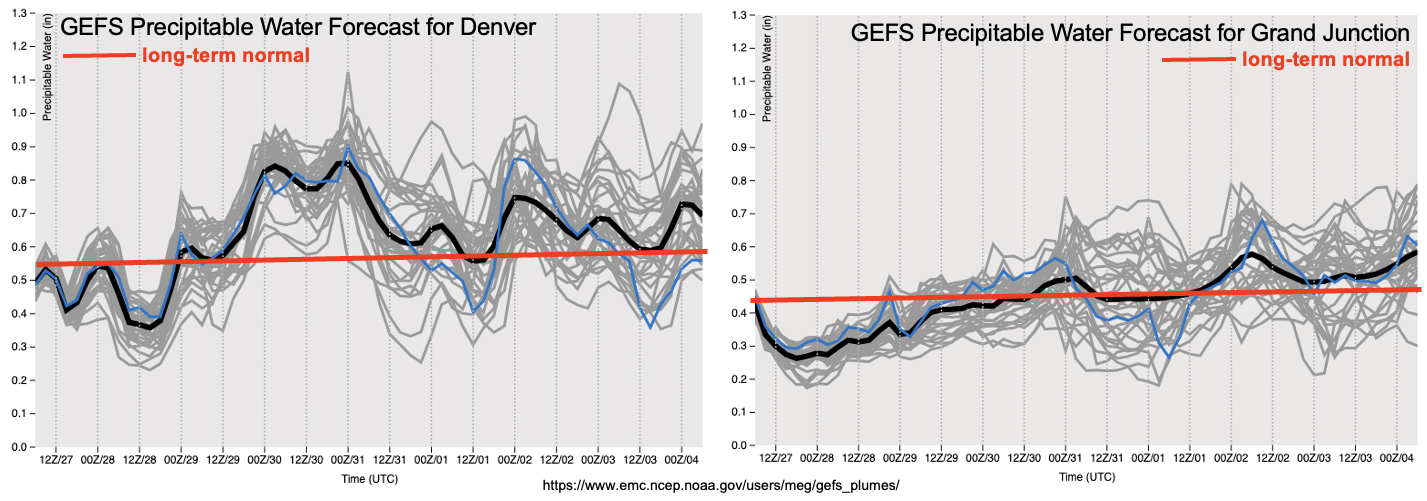
As shown in the GEFS forecast PW plumes, we see a very distinct surge of moisture in the Denver forecast, with PW approaching 1 inch. However, one important caveat regarding heavy rainfall chances is that the strong cool front will likely limit instability along and north of it. In fact, the trend in model guidance over the past 24-48 hours has significantly cooled boundary layer temperatures north of I-70, which will cause more gentle, stratiform precipitation here. The real area of interest for this event, from the perspective of heavy rainfall and flooding will be over the southeast quadrant of Colorado, where Saturday and Sunday will have a well-juxtaposed combination of moisture, instability and relatively light steering winds to warrant an Elevated flood threat. Unlike the past two precipitation events, heavy rainfall will likely be the dominant threat with Event #1, as opposed to severe weather, given relatively weak wind shear.

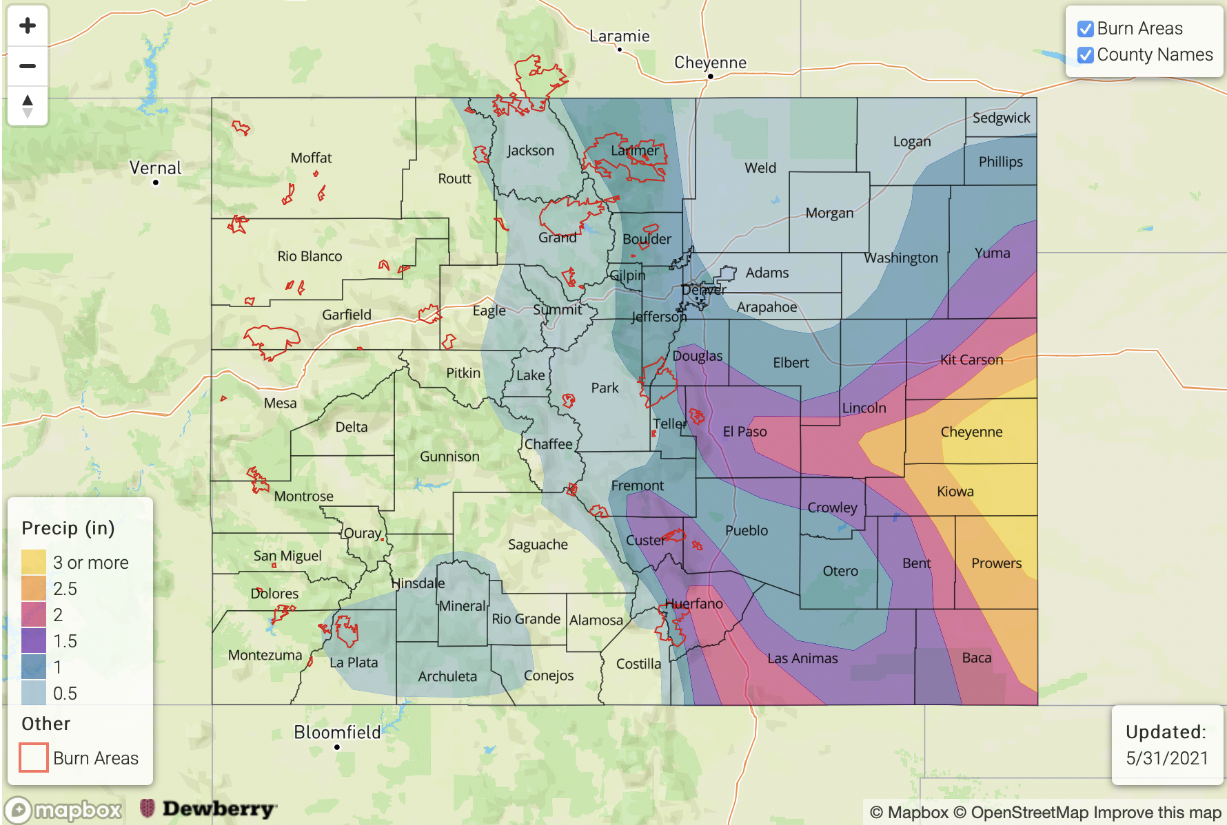
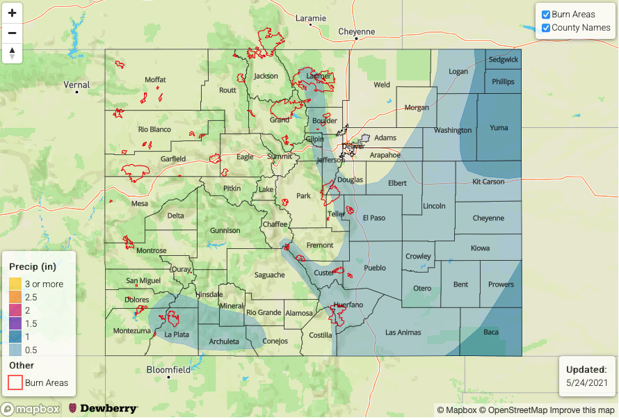
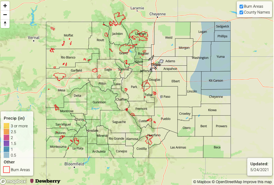
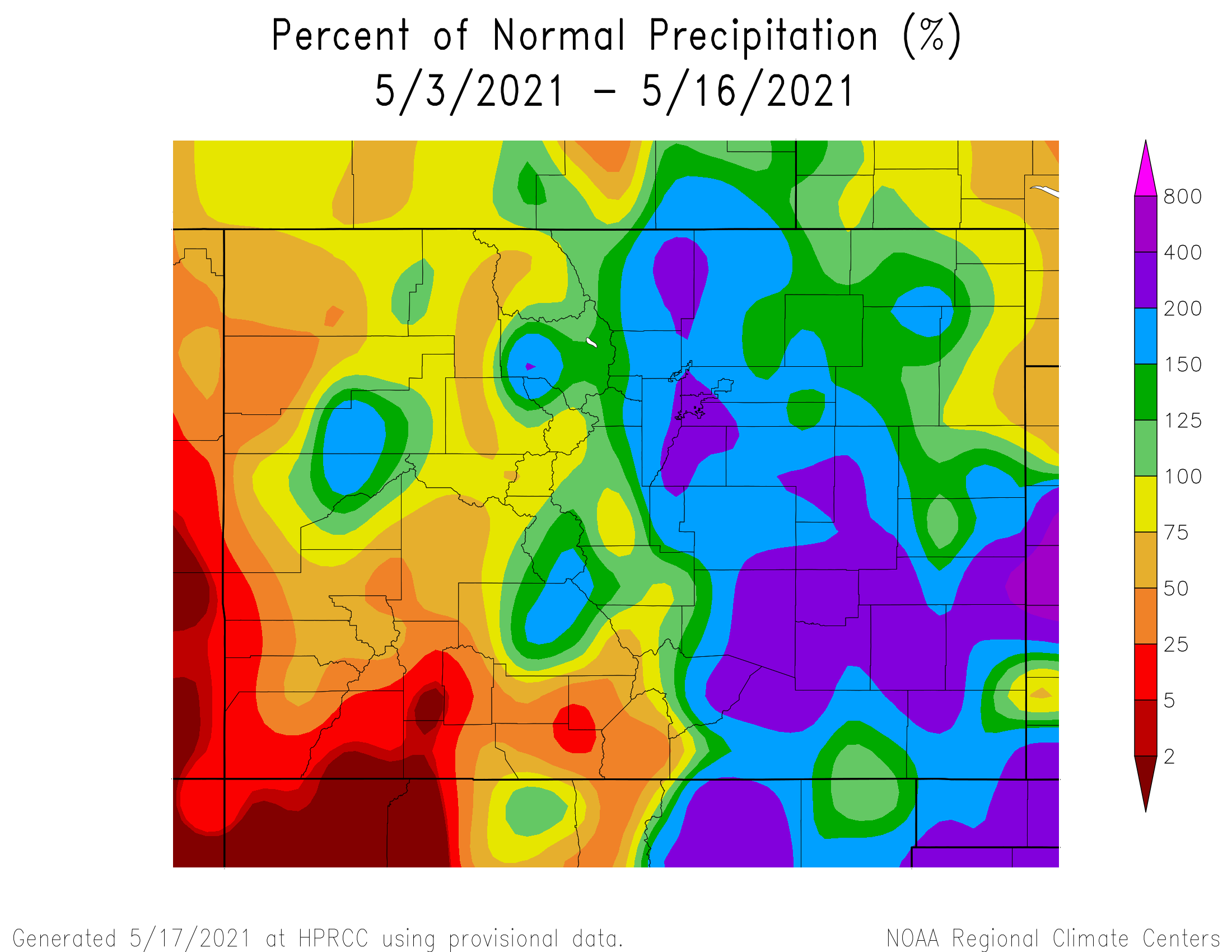
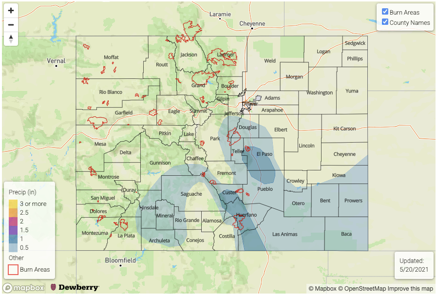
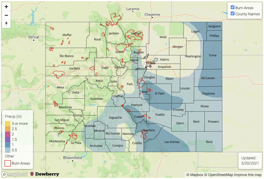
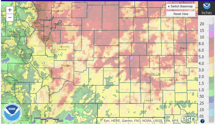
Before moving on, and of relevance to Event #1, it is worthwhile to discuss just how impressive some of the spring precipitation has been across parts of eastern Colorado. The map below shows 30-day total precipitation as estimated by the NOAA Stage IV product, which takes into account both rainfall gauges and radar estimates. Widespread parts of eastern Colorado have received over 5 inches of rainfall, with isolated locations exceeding 8 inches and approaching 10 inches over this period. For reference, 10 inches of rainfall over eastern Colorado over a 30-day period equates to roughly a 1% chance of occurring (i.e. also sometimes referred to as a 1 in 100 year event). If the precipitation totals forecasted for Event #1 materialize, some of these locations could approach or even exceed 0.2% (1 in 500 year) or even possibly 0.1% (1 in 1000 year) chances of occurrence. Given that all of this rainfall has occurred, thus far, without significant flooding is certainly welcome news.

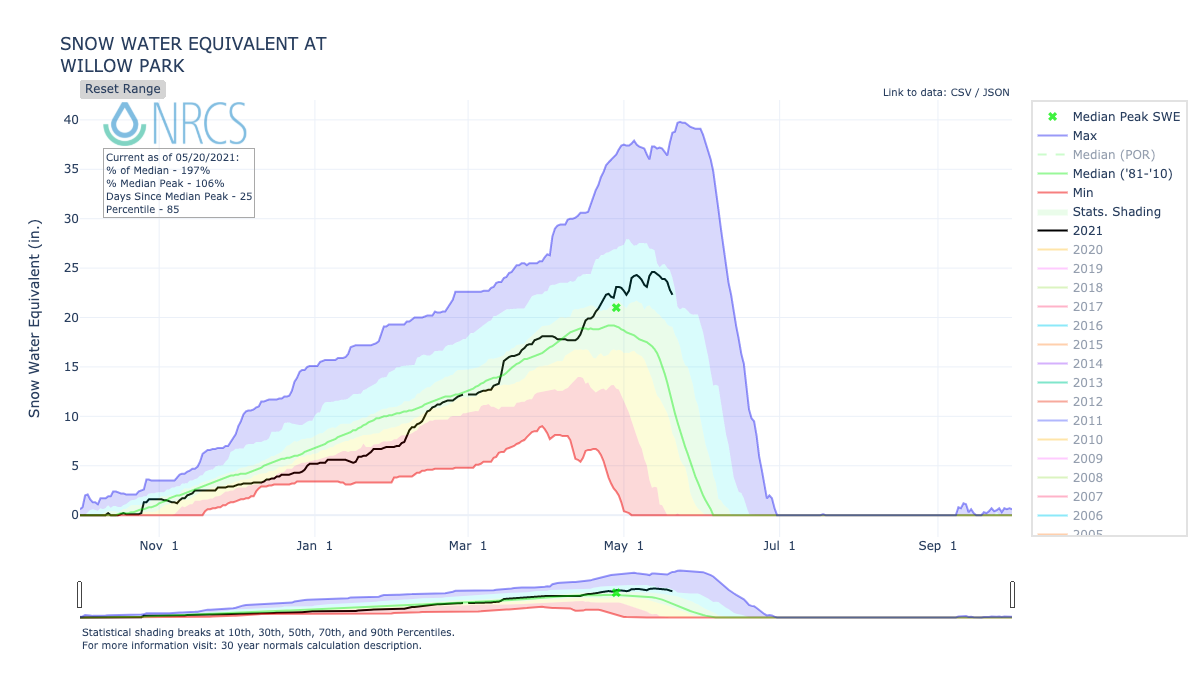
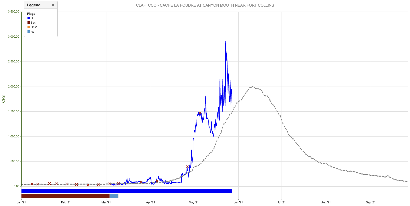
The last matter to discuss in this Outlook is snowmelt. As discussed in past Outlooks, most major river basins are expected to see below normal snowmelt and flow (or even significantly below normal, like the Colorado River). The one exception continues to be the South Platte River, and more specifically its tributary, the Cache La Poudre. As shown in the hydrograph below, the river has experienced above normal flow, sometimes significantly so, for nearly one month now. With the upcoming Event #1, this flow will continue to rise. Furthermore, much warmer temperatures by later next week imply the first prolonged pulse of high elevation snow-melt in this basin. In short, we expect significantly above normal peak flow to occur sometime in June. An Elevated flood threat has been issued starting late next week in anticipation of the high elevation snow melt. However, it is not yet clear whether the river will actually enter flood stage at this time, so stay tuned.

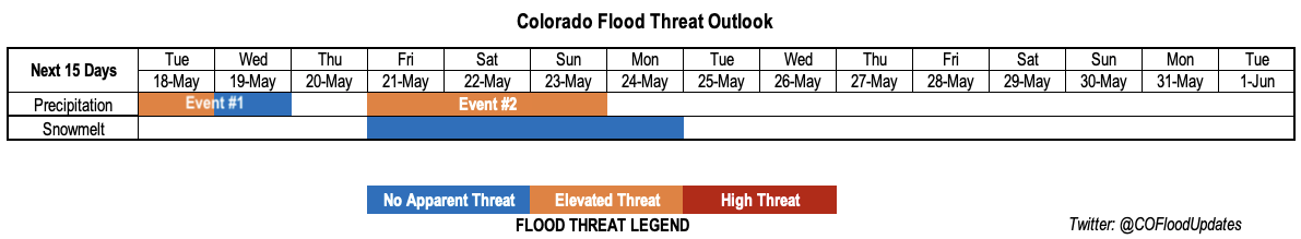
Below, we discuss the identified precipitation event in more detail.

Event #1: Friday-Wednesday (May 28 – June 2)

A prolonged, Elevated Flood Threat through the period for repeated rounds of heavy rainfall

Thunderstorm activity will increase in coverage beginning Friday, but especially on Saturday through Memorial Day (Monday) as the trough and cold front combination approach Colorado. On Saturday, we expected areas east of the Continental Divide to see at least short-term heavy rainfall, but flooding concerns should stay limited to the Northeast Plains and Southeast Plains where 1-hour rainfall up to 2.0 inches and 3-hour rainfall up to 3.5 inches will be possible. By Sunday, a cool front will limit instability in northern Colorado, but already saturated areas in eastern Colorado will see another round of heavy rainfall with maximum 1-hour intensity up to 1.9 inches and 3-hour intensity up to 3.7 inches. Overall, isolated locations mainly along the Kansas border south of I-70 will likely experience over 5 inches of rainfall over a 48-hour period. Isolated flash flooding will be possible along with some flooding of smaller tributaries in the Arkansas and Republican river basins. By Monday, the threat will shift southward towards the NM border, as cool stable air should prevail further north. Max 1-hour rainfall up to 1.5 inches per hour over the Raton Ridge warrant a continuation of the Elevated threat.

It is also important to note that eastern Colorado “major” fire burns (East Troublesome, Cameron Peak, Calwood and Spring Creek; see Fire Burn Forecast page) will be under elevated threat during the coming period. At this moment, it appears Spring Creek will see the highest potential for runoff issues, as the burn areas further north should experience a limited duration of high rainfall intensity.

FTO 05-24-2021: Dry with a Warm-Up Then Storms Return for Memorial Day Weekend

Issue Date: Monday, May, 24th, 2021
Issue Time: 2:40PM MDT
Valid Dates: 5/25 – 6/8

A chain of fairly fast-moving troughs and ridges will propagate across the state this next week. First, southwesterly and westerly flow aloft under a building ridge will help to keep the skies dry through Tuesday. On Wednesday, a weak trough breaks up this ridge and pushes some mid-level energy across the state. Without much moisture accompanying this trough, outside some isolated severe storms for the far eastern plains, it should remain dry. Then drying returns as another weak ridge builds overhead with very warm temperatures forecast. It should reach the upper 80Fs across the Southeast Plains and western valleys Friday into this weekend.

Event #1 begins Memorial Day weekend with rainfall forecast first over the plains, and then back over the mountains/adjacent plains. PW looks again to be highest over eastern Colorado, and a rapid rise in PW on Sunday will warrant an Elevated flood threat. Models hinting at cooler temperatures behind a potentially strong cold front on Monday, which if this occurs, it should help temper rainfall rates with upslope flow. However, burn areas will need to be watched closely as precipitation chances will increase over the mountains. Monday/Tuesday will be the best shot for measurable rainfall over the western mountains as winds aloft turn more southerly.

After Tuesday, northwesterly flow aloft and building ridge to our north/west will keep the state dry and help produce more seasonable temperatures. There’s still plenty of changing factors for Event #2, but a broad troughing pattern should return unsettled weather for that period and perhaps further into the work week. At this time, there is No Apparent Flood threat.

Streamflow

Currently, there is a Flash Flood Watch for the Purgatoire River near Las Animas where a crest up to 9 feet is forecast tonight into Tuesday midday. On Saturday, after the 3+ inches of rainfall fell over the area, the Purgatorie River at Trinidad crested at 6.63 feet. This broke the previous record of 6.2 feet, but is still well below the Action stage (10.5 feet). The Cache La Poudre River at Greeley is also at or near Action stage today, so low land nuisance flooding is likely for the next couple of days.

Warming temperatures throughout this week and into this weekend mean that runoff will likely increase. As discussed in pervious posts, this will mostly affect smaller creeks and streams over the eastern and northern mountains. You can see today’s SWE and WY precipitation totals at SNOTEL sites across your water basin here: NRCS

The cooler temperatures returning to start next week should help temper the flows and settle the snowpack at the higher elevations again. Not foreseeing any widespread, heavy rainfall this weekend over areas with potentially elevated flows right now, so there is No Apparent Threat.

Event #1: SaturdayTuesday (5/296/1)

Elevated/No Apparent flood threat as severe storms return to the eastern plains and upslope flow returns behind a cold front.

Looks like more severe weather will be possible on both Saturday and Sunday across the eastern plains. Threats from the severe storms will include large hail, strong outflow winds, local heavy rainfall and perhaps a couple tornadoes. Steering flows look to be a little bit slower than this last weekend, so there is an Elevated flood threat for Sunday when PW should peak. The flood threat may need to be upgraded in Thursday’s FTO for Saturday. On Monday, precipitation turns more stratiform and fills in over the mountains with cooler temperatures forecast for the holiday. Burn areas will need to be watched more closely on both Monday and Tuesday for embedded convection or prolonged periods of rainfall.

Event #2: SaturdayMonday (6/56/7)

No Apparent flood threat as a broad trough brings stormy weather back into the forecast.

Another weekend with storms is in the forecast to start the month of June. There’s still plenty of uncertainty with the forecast, but a broad trough will return rainfall chances to the state during this period. Currently this looks like an event favoring eastern Colorado again for the higher totals, but measurable precipitation over the western mountains will be likely as moisture is drawn up from the Pacific and Gulf of California. At this time there is No Apparent flood threat issued.

FTO 05-20-2021: Warmer With Low-End Elevated Threat Along With Severe Weather

Issue Date: Thursday, May 20, 2021
Issue Time: 12:15PM MDT
Valid Dates: 5/21-6/4

It appears that Colorado (especially the eastern half of the state) is finally giving Seattle its weather back, in exchange for conditions more in line with a typical late spring here. As shown in the water vapor image, below, an amplified upper-level pattern continues across the eastern Pacific Ocean, extending into western North America. Currently, Colorado is under a transient upper-level ridge that will quickly be replaced by an incoming upper-level trough (Event #1). As was the case with the storm from last weekend, this feature will cut-off from the main flow, making it move very slowly, if at all. Some guidance has it stalling west of the Four Corners and gradually dissipating after 72-96 hours.

Although the GEFS PW plumes at Denver, below, show a significant increase in PW to values in the 0.8-0.9 inch range, there are several mitigating factors regarding the threat of heavy rainfall. First of all, steering winds with the system will be much stronger than the past one, which is generally a constraining factor on heavy rainfall. Second of all, because the system will slow down or even stall, only far eastern Colorado will experience meaningful upslope flow that is usually an essential ingredient for heavy rainfall east of the Continental Divide. Third of all, there will be incoming very dry air, after the initial plume of subtropical moisture on Friday, that will act to sharpen a dryline in the eastern part of the state. Anywhere west of the dryline, it is unlikely that significant rainfall will occur. The lone exception to this statement will be the San Juan Mountains that will experience a very welcomed moderate precipitation event on Friday as the atmospheric moisture plume gets perfectly directed upslope into the 14,000 foot range (as an interesting and relevant aside, note that Wolf Creek Pass is one of the wettest locations in the state with average annual precipitation likely exceeding 60 inches along its southwest face!).

Although there are many mitigating features for heavy rainfall potential as discussed above, there is still enough moisture, instability and dynamics to warrant a low-end Elevated Flood Threat with Event #1. It is likely that the severe weather risk will steal the headlines, but storms in eastern Colorado will be capable of heavy rainfall mainly at the 1-hour duration. Furthermore, given the north-south orientation of both the dryline (an anchor of storm formation) and southerly steering winds (i.e. storms will move northward), there will be potential for training of cells that could cause flooding over the 2-hour and 3-hour durations as well.

After Event #1, dry air will overtake most of the state for several days. Afternoon thunderstorms will still be possible over the far eastern areas, but flooding appears very unlikely right now. Thereafter, some indication of a cool front passage from the north along with a resurgence in moisture from easterly return flow warrants the identification of an Event #2, currently of importance mainly for eastern Colorado.

The last matter of importance is the status of the snowmelt, which typically peaks within a few weeks either side of today across the state. As we have alluded to previously, the only basin of concern is the South Platte River. Below, the Willow Creek SNOTEL site (10,700 ft) shows a SWE of 23 inches, which is almost double the normal value for this time of year. This could be a concern if very hot weather was in the forecast. However, given the presence of only slightly above normal temperatures and relatively dry conditions, it does not currently appear that snowmelt will cause any widespread flooding concerns, only minor nuisances in smaller streams.

Below, we discuss the two identified precipitation events in more detail.

Event #1: Friday-Sunday (May 21 – May 23)

A low-end Elevated Flood Threat through the period mainly for isolated short-duration flash flooding; severe weather also likely

Thunderstorm activity will begin today but rainfall (and snowfall) coverage will increase Friday-Sunday, first targeted over mainly southwest and southern Colorado where the rainfall will be most welcomed. The San Juans could see max 1-hour rainfall up to 0.6 inches, with 24-hour accumulation exceeding 1 inch over the higher terrain. Over the highest peaks, this precipitation will fall as snow. East of the Continental Divide, afternoon flare-ups of showers and thunderstorms will occur Friday-Sunday with the heaviest rainfall chances in far eastern Colorado, where PW will approach 1 inch. Along the NE, KS and OK borders, activity could persist into the evening and early overnight hours. Max 1-hour rainfall up to 1.8 inches is possible, with max 3-hour rainfall up to 3.0 inches locally. This could result in small-scale flash flooding, along with field and street ponding. In addition, severe weather will be likely with large hail and gusty winds being the primary threat.

Event #2: Wednesday-Thursday (May 26 – May 27)

No Apparent Flood Threat as storms appear to return to eastern Colorado

Although there is significant uncertainty as to the moisture return, it appears that a cool front will return enough moisture and upslope flow into the state for an increase in thunderstorm activity, mainly over the eastern Plains. Currently it appears the dryline boundary will be far enough east that only areas along the NE, KS and OK borders will stand the chance for meaningful rainfall exceeding 0.5 inches.

FTO 05-17-2021: Ongoing Storm To Move Eastward But Next Event On Its Heels

Issue Date: Monday, May 17, 2021
Issue Time: 1:30PM MDT
Valid Dates: 5/18-6/1

The eastern half of Colorado has experienced a prolonged very wet stretch, with plenty of severe weather and flooding reported mainly across southeast Colorado. A few counties along the Kansas border have received over 5 inches of rainfall in the past three days, which is close to half of the annual rainfall in some areas! This has certainly been welcomed from the standpoint of denting the ongoing drought, but at the expense of flash flooding. Fortunately, instances of flooding have been generally isolated and very temporary in duration thus far.

As shown in the water vapor image, below, the cut-off upper-level low pressure responsible for the recent rainfall will continue to move eastward. Tuesday will mark the last day with an Elevated Flood Threat for this event (Event #1), followed by lighter precipitation on Wednesday. However, after only a short break, with much warmer temperatures statewide on Wednesday and Thursday, another slow-moving feature (Event #2) will approach the state from the west by late Thursday. One interesting note about this feature is that it will be a combination of two disturbances, with the southern one having significant access to subtropical Pacific moisture.

As seen in the GEFS PW plumes, below, a significant increase in moisture is expected with this event with Denver PW expected in the 0.8-0.9 inch range. As an aside, note that the existing storm only managed a PW of about 0.75 inches in Denver. Fortunately, even Grand Junction will see in an increase in moisture, although whether that translates to rainfall is less certain over northwest Colorado. One major difference between Event #2 and the ongoing event is the much stronger steering winds aloft. This will have two main implications: first, to limit rainfall rates, and second, to increase the chances of severe weather, especially east of the Continental Divide. However, despite the expected faster steering winds, strong dynamics and a large moisture plume still warrant an Elevated Flood Threat for Event #2, mainly for the isolated risk of flash flooding from short-term rainfall.

In the wake of Event #2, a significant decrease in moisture is expected, along with warmer temperatures. Thus, no additional precipitation events are currently foreseen.

Switching topics to snowpack, the only basin in Colorado that has an above-normal snowpack is the South Platte. We anticipate a strong ramp-up in snowmelt runoff by early Friday given the much warmer temperatures on Wednesday/Thursday and possible (non-snow) precipitation later. We are currently keeping an eye on the Cache La Poudre, Big Thompson and St. Vrain basins, where above normal flows are very likely. However, flows are currently expected to stay below flood stage, although smaller tributaries could certainly see some isolated areas of flooding near river banks.

Below, we describe each precipitation Event in more detail.

Event #1: Tuesday-Wednesday (May 18 – May 19)

An Elevated Flood Threat on Tuesday with risk decreasing by Wednesday

Tuesday will continue to bring the chance of heavy rainfall mainly to the Southeast Mountains, Palmer Ridge, Raton Ridge and Southeast Plains. Maximum one-hour rainfall up to 1.1 inch per hour will be possible over isolated locations, which could cause flash flooding, debris slides and mud flows. Fire burns in the Southeast Mountains (notably Decker and Spring Creek) will remain under threat for flooding. The threat of severe weather will subside by Tuesday, but large hail will still be possible in far southeast areas. Parts of the San Juans could also see some much welcomed rainfall, but it should remain below thresholds for flooding.

By Wednesday, some leftover showers and weak storms are possible, but coverage will be limited to mainly the Southeast Plains.

Event #2: Friday-Sunday (May 21 – May 23)

An Elevated Flood Threat through the period mainly for isolated short-duration flash flooding; severe weather also looking probable

Rainfall coverage will once again increase by Friday, first targeted over mainly southwest and southern Colorado where the rainfall will be most welcomed. The San Juans could see max 1-hour rainfall up to 0.6 inches, while eastward, the Southeast Mountains could see rainfall up to 1.0 inches. By Saturday and Sunday, it currently appears that coverage will move generally northeastward. We expect at least one significant round of afternoon and evening rainfall, originating off the higher terrain and moving northeast. Currently max 1-hour rainfall up to 1.7 inches appears possible, though stronger intensity could occur towards the KS/NE borders if moisture is sufficient. Organization of afternoon storms looks likely, given the strong dynamics, which could lead to threatening rainfall at the 3-hour and 6-hour durations as well. This will need to be further investigated in Thursday’s FTO. Regardless, severe weather, notably large hail (possibly very large) and strong straight-line winds appears likely for both the Southeast Plains and Northeast Plains, and possibly further west.

Rainfall chances for the Front Range, Urban Corridor and most areas west of the Continental Divide are less certain, and these areas could stay on the drier side given drier air infiltration and/or strong downsloping flow.